CNYC Philadelphia Alternate
Route Options
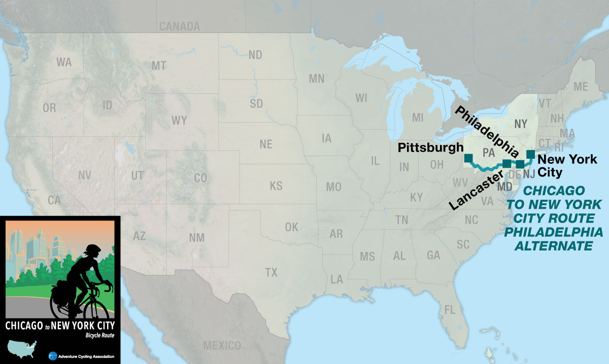
The Chicago to New York City Bicycle Route includes a main route and the Philadelphia Alternate, which stretches from Pittsburgh, Pennsylvania to New York City. This page describes the 518.5-mile Philadelphia Alternate from Pittsburgh, Pennsylvania to New York City, New York. If you choose to combine the main route with the Philadelphia Alternate the mileage is 1,172.9 miles. On section 3, in Pittsburgh, you’ll find the intersection where you’ll switch maps from following the main route to the Philadelphia Alternate.
To make an informed decision about whether to choose the main route or the Philadelphia Alternate here is a list of the major differences.
- Main route: more hills and short steep hills in eastern Pennsylvania and New York with more paved roads.
- Philadelphia Alternate: 150 miles on the Great Allegheny Passage (GAP), mostly unpaved on a crushed limestone surface, and 85 miles on the C&O Canal Trail, mostly unpaved on a dirt surface which can be slick and hard to ride in wet conditions. The maximum grade is 1.5%. There are multiple tunnels. Eastern Pennsylvania is rolling while New Jersey becomes flatter the closer the route gets to the Atlantic Ocean.
The Steel City to the Big Apple
On the Philadelphia Alternate you’ll ride the GAP and an unpaved 85-mile section of the C&O Canal Trail from Cumberland to Williamsport, Maryland. Within the 85 miles, the route joins the paved Western Maryland Rail Trail for 21 miles. After leaving Philadelphia, the route goes east to the New Jersey shore and ends with a ferry ride into New York City from the south.
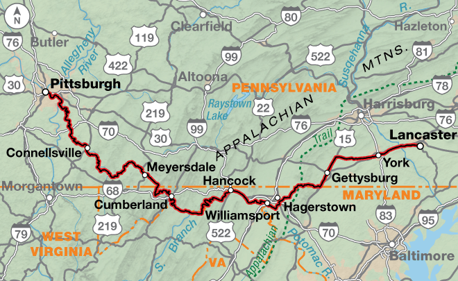
The GAP is a multi-use trail that primarily follows railroad corridors from Pittsburgh, Pennsylvania to Cumberland, Maryland. Some sections are paved, but the majority of the trail has a smooth crushed limestone surface. Leaving Pittsburgh, the route follows the Three Rivers Heritage Trail along the south and west side of the Monongahela River. At McKeesport, the GAP crosses the Monongahela River on a pedestrian/cyclist bridge and follows paths through an industrial area and downtown. Then it begins heading upstream along the Youghiogheny River. South of McKeesport, you’ll cross the Youghiogheny River and begin the long gradual climb to the Eastern Continental Divide at 3,292 feet. Near Ohiopyle State Park, expect significant bicycle and pedestrian traffic on the GAP. This is a popular white water rafting and outdoor recreation destination, especially during summer months.
There are four tunnels, ranging from 849 feet to 3,294 feet in length. The Big Savage Tunnel is the longest and lies just east of the Eastern Continental Divide. It has lights, and is closed seasonally from mid-December to mid-April. The Salisbury Viaduct, 1,908 feet in length, and the Keystone Viaduct, 909 feet in length, are up to 100 feet high and use the original railroad structures.
The historic Mason Dixon Line represents the state line between Pennsylvania and Maryland. This line became widely known as the symbolic divide between the Northern and Southern states during the Civil War.
From Frostburg, Maryland to Cumberland, the GAP parallels the Western Maryland Scenic Railroad (WMSR). The 914 ft. Brush Tunnel is shared by the WMSR and the GAP — cyclists are cautioned to not be in the tunnel when a train is in it or when approaching the tunnel.
In downtown Cumberland, the GAP seamlessly meets the C&O Canal Trail at the Canal Place Heritage Area. The C&O Canal Trail follows the towpath of the C&O Canal through the Chesapeake and Ohio Canal National Historical Park. The trail surface is mostly dirt and can be slick and hard to ride in wet conditions. All hikers and bikers must yield the right of way to horses and mules. Water sources can be scarce along the C&O, especially on the 60 miles between Cumberland and Hancock. The 3,118-ft. Paw Paw Tunnel was built to avoid six miles of horseshoe-shaped bends on the Potomac River. Cyclists need to use lights to navigate the tunnel.
Beginning 4.5 miles east of Little Orleans, the Western Maryland Rail Trail provides a paved trail for 21 miles to Fort Fredrick State Park. At Williamsport, the route leaves the C&O Canal Trail and uses state highways around Hagerstown, Maryland.
The route follows hills and valleys on county roads and state and federal highways using several signed BicyclePA routes across south central Pennsylvania. It passes through Gettysburg National Military Park. Downtown Gettysburg has significant, though slow-moving traffic during tourist season.
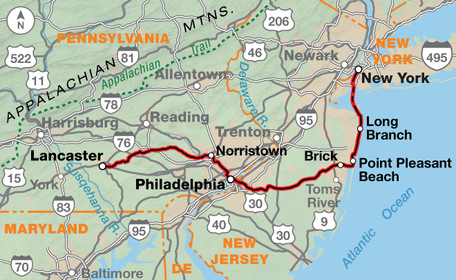
After crossing the Susquehanna River, the route enters Lancaster County, known as “Pennsylvania Dutch Country” and the city of Lancaster. The county is home to many Amish families. Just as the Amish do not carry personal photographs or display them in homes, they do not want others to take photographs of them. Many visitors find it difficult not to do so. Please do not take photographs in which faces are recognizable. Refraining from taking photos is more than just a courtesy; it is respect for the Amish and their way of life.
East of New Holland, state highways connect to rural roads near Pughtown. The route uses bike paths through Valley Forge National Historical Park, then it joins the multi-use Schuylkill River Trail, which provides mostly off-road riding into downtown Philadelphia. At the Philadelphia Museum of Art, you’ll ride city boulevards to the Ben Franklin Bridge and use the south walkway to cross the Delaware River into New Jersey. On the Camden side of the bridge, it may be necessary to remove panniers to negotiate the two-story stairway and bike ramp. Traffic can be heavy for the next 15 miles.
Between Medford and Mantoloking the route follows State Route 70. The highway can be busy but has excellent shoulders. The communities along the Atlantic Ocean are a popular vacation spot and boast of numerous boardwalks, amusement parks, arcades, and entertainment. Heading north, the route stays close to the shoreline using avenues, bike paths, boardwalks, and occasionally busy boulevards. Bicycles are probably the best mode of transportation to negotiate the traffic during tourist season.
At Highlands, Seastreak operates numerous ferry departures to the Pier 11/Wall St. terminal in Manhattan. Additional services and Seastreak ferry departures are also available in Atlantic Highlands, 2.5 miles northwest of Highlands. The towns are connected by the Bayshore Trail/Henry Hudson Bike Trail.
Once the ferry reaches New York City, from the Pier 11/Wall St. terminal, the route goes five blocks west on bike paths and ends at Battery Park, located at the southern tip of Manhattan Island. The park includes statues and memorials. Along the waterfront, Statue Cruises offers ferries to the Statue of Liberty and Ellis Island.
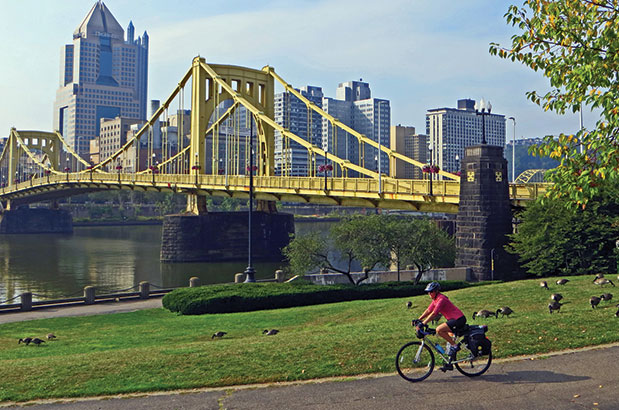
Photo: Jim Neu
Nearly half of the miles on the Philadelphia Alternate are on the Great Allegheny Passage (GAP) and the C&O Canal Trail. The maximum grade on these trails is 1.5%. You’ll ride through small towns, forests and along water courses. There are multiple tunnels. On the C&O Trail, all hikers and bikers must yield the right of way to horses and mules. Once you leave the C&O, there will be some hills and one large climb and descent over the Blue Ridge Summit southwest of Gettysburg. The terrain becomes rolling, then flatter as you reach the Atlantic shoreline.
| Chicago to New York City Philadelphia Alternate - Main Route | ||||
|---|---|---|---|---|
| Section | Distance | Elevation | Total Climb | Avg. Climb/mile |
| Total | 518.5 miles | Minimum: 0 ft.Maximum:2735 ft. | 15225 ft. east bound15560 ft. west bound | 29 ft. per mi. north bound30 ft. per mi. west bound |
| 1 | 338.7 miles | Minimum: 0 ft.Maximum:2735 ft. | 10370 ft. east bound10320 ft. west bound | 31 ft. per mi. east bound30 ft. per mi. west bound |
| 2 | 179.8 miles | Minimum: 0 ft.Maximum:680 ft. | 4855 ft. east bound5240 ft. west bound | 27 ft. per mi. east bound29 ft. per mi. west bound |
This route can be ridden from mid-spring to mid-fall (typically April to mid-September). Expect high temperatures and humid conditions during the summer. Thunderstorms are responsible for most of the rainfall. Due to changing local conditions, it is difficult to predict any major wind patterns along the route.
Services are generally plentiful, though there will be occasional exceptions. Multiple bike shops are located in the larger metropolitan areas. Water sources can be scarce along the C&O, especially on the 60 miles between Cumberland and Hancock, so plan to carry extra water. To be safe at water sources, carry iodine tablets or a filter to treat water. Alerts about water and the C&O are posted here: advcy.link/cpkohtrlcond.
Some cyclists may want to ride this route during the colors of autumn. If you do, call ahead to verify campground availability because many close after Labor Day. If staying indoors, make advance reservations.
Some campgrounds will charge a cyclist traveling alone less if they have hiker/biker sites, but often they will charge the price of a regular tent site, and that can easily be $10-$20/night. If you’re friendly and ask around, you can often get yourself invited to camp in a yard. Many small town city parks are free to camp in.
You may also wish to sign up with Warmshowers, a reciprocal hospitality site for bicycle travelers, for other overnight options.
Photo: Jim Neu
Route Highlights
- Eastern Continental Divide, Section 1
- Mason Dixon Line, Section 1
- Laurel Highlands, Section 1
- Gettysburg National Military Park, Section 1
- Amish and Pennsylvania Dutch Countryside, Section 2
- Valley Forge National Historical Park, Section 2
- National Constitution Center, Section 2
- New Jersey Shore, Section 2
More Route Resources
- How to Travel with your Bike on Amtrak
- U.S. Bicycle Route System
- U.S. Bicycle Route 50 (Pennsylvania)
- BicyclePA Routes (Pennsylvania)
- Pittsburgh Bike Map (Pennsylvania)
- Great Allegheny Passage (Pennsylvania)
- Three Rivers Heritage Trail (Pennsylvania)
- Chesapeake and Ohio (C&O) Canal National Historical Park (Maryland)
- U.S. Bicycle Route 50 (Maryland)
- C&O Canal Trail Bicycling Guide (Maryland)
- C&O Canal Trail Alerts (Maryland)
- Western Maryland Rail Trail Information (Maryland)
- Western Maryland Rail Trail Map (Maryland)
- Schuylkill River Trail (Pennsylvania)
- Henry Hudson Bike Trail (New Jersey)
- Seastreak Ferry (New Jersey & New York)
- Statue Cruises to Statue of Liberty and Ellis Island (New York)
- Connect and share photos with other riders on Instagram: #acaChi2NYC
Updates to Recently Released Maps
If you are planning a bike tour, be sure to get the most recent map updates and corrections for your route by selecting the route, and the appropriate section(s), from the drop-down menu below.
Over time maps become less useful because things change. Every year Adventure Cycling’s Routes and Mapping Department create map updates and corrections for every map in the Adventure Cycling Route Network, which now totals 52,047 miles. With the help of touring cyclists like you, we receive updates on routing, services, camping, and contact information. Until we can reprint the map with the new information, we verify the suggested changes and publish corrections and updates here on our website.
PLEASE NOTE: Covid has been particularly hard on the small businesses along our routes. While we do our best to keep the maps and these online updates current, you may encounter more closed businesses and longer stretches with limited or no services.
Refer to these updates for the most current information we have and submit reports of changes to the Route Feedback Form for the cyclists coming after you.
NOTE: Map updates and corrections only pertain to long term changes and updates. For short term road closures, please see the Adventure Cycling’s Routes Temporary Road Closures discussion in our Forums.