7. DeFuniak Springs, FL to St. Augustine, FL Detail
Southern Tier Section 7 Detail Image
Experience fascinating landscapes, fabulous food, and diverse cultures.
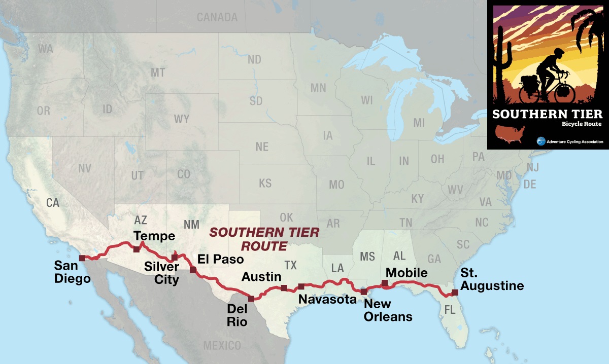
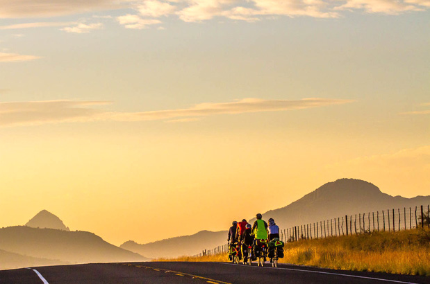
The Southern Tier Bicycle Route is our shortest cross-country route and offers a wide variety of terrain, vegetation, climate, and people all the way across the nation from the Pacific to the Atlantic. The route is rich in human culture and history — ranging from the Spanish and Mexican influences in California, to the ancient indigenous pueblo cultures in Arizona and New Mexico, to the imprint of the Spanish conquistadors in Texas, to the bayous and French influences of Louisiana, to the Old South of Mississippi and Alabama, to a four-hundred-year-old city in Florida.
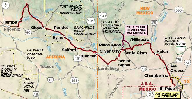
After climbing east from San Diego and topping out at 3,890 feet at the Tecate Divide, you’ll enter desert country. The route travels through the Yuha Desert and the below-sea-level, irrigated Imperial Valley. In Arizona, snowbirds abound as the route travels through Phoenix and its surrounding communities. The Besh Ba Gowah Archeological Park in Globe, though off route, is very interesting. You’ll be riding through dry, sparsely populated ranch country where every town will be a welcome sight. Don’t pass up the chance to top off your water bottles. New Mexico offers Silver City for the latte drinkers, along with the Gila Cliff Dwellings National Monument (on the Gila Cliff Dwellings Alternate), which are some of the best preserved Mogollon cliff dwellings around.
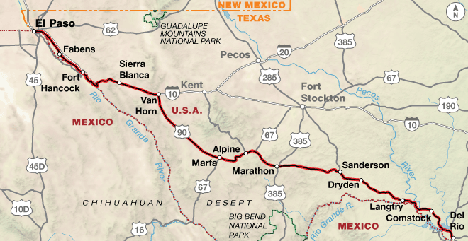
The ride along the Rio Grande into El Paso, Texas, is a treat for bird lovers, especially during migration season, when birds are flying north or south. Texas dominates this route, taking up an entire third of the mileage. Starting in El Paso, just across the Rio Grande River from Juarez, Mexico, the route follows the river southward before turning east. Marfa, a small desert town in west Texas, is known as an arts hub. Southeast of town, there is a viewing platform from which the mysterious orbs known as the “Marfa Lights” phenomenon can sometimes be seen. After Alpine, towns are few and the country desolate, full of sagebrush and tumbling tumbleweeds. As you travel through central Texas, the terrain starts to feel like the Alps, but this is actually the famous “hill country.” This diverse area serves some great barbeque. In Austin, make sure you go hear some of the diverse music available at the nightclubs on Sixth Street.
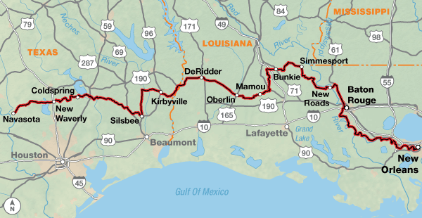
Louisiana is like no other state in the United States due to its history, language, culture, and food. First of all, they have parishes instead of counties, due to early white settlers being Roman Catholic under French and Spanish rule. Boundaries generally coincided with church parishes when the U.S. bought the Louisiana Purchase in 1803. Traveling right through the middle of Cajun country, in places like Mamou, a stop in a cafe is a trip unto itself. The crowd is speaking English, but you can’t understand the words. New Orleans is a highlight of the route, famous for its distinctive music scene, Creole food, unique dialects, and many festivals and celebrations. Try to hear some lively Cajun music if you have the time. Mississippi offers some beachfront riding into Alabama, where the route crosses a bridge to Dauphin Island. From there it’s a ferry ride across Mobile Bay to Gulf Shores, and some of the whitest beaches in the world. If the ferry is closed due to inclement weather, you will have to take the alternate route through Mobile.
The scenery varies greatly across Florida, from the historic coastal city of Pensacola to the alligator-filled waters in the area around Palatka. The route ends in St. Augustine, a city full of interesting buildings, and the Castillo de San Marcos, a fort that has guarded the city’s waterfront for over four centuries.
Photo by Dennis Coello
The Southern Tier route offers challenging terrain right from the start, with some longer climbs leaving San Diego all the way up to the Tecate Divide, about 72 miles east of the Pacific Ocean. There are two mountain passes in New Mexico, the highest being Emory Pass at 8,228 feet, which is also the route’s highest point. The Gila Cliff Dwelling Alternate, just north of Silver City, New Mexico, goes to the Gila Cliff Dwellings National Monument and offers some steep, challenging, rolling climbs and descents, as does the hill country west of Austin, Texas. East of Austin the route flattens out as it meanders through piney woods, by bayous, along farmlands and woodlots, and past the Gulf Coast all the way to the Atlantic Ocean.
Southern Tier - Main Route
Section
Distance
Elevation
Total Climb
Avg. Climb/mile
Total
3078.4 miles
Minimum: -155 ft.Maximum:8,185 ft.
101,730 ft. east bound102,490 ft. west bound
33 ft. per mi. east bound33 ft. per mi. west bound
1
432.4 miles
Minimum: -155 ft.Maximum:4,120 ft.
17,125 ft. east bound16,015 ft. west bound
40 ft. per mi. east bound37 ft. per mi. west bound
2
512.9 miles
Minimum: 1,155 ft.Maximum:8,185 ft.
31,600 ft. east bound29,540 ft. west bound
62 ft. per mi. east bound58 ft. per mi. west bound
3
432.6 miles
Minimum: 975 ft.Maximum:5,115 ft.
10,580 ft. east bound13,360 ft. west bound
24 ft. per mi. east bound31 ft. per mi. west bound
4
433.0 miles
Minimum: 150 ft.Maximum:2,385 ft.
20,665 ft. east bound21,425 ft. west bound
48 ft. per mi. east bound49 ft. per mi. west bound
5
570.4 miles
Minimum: 0 ft.Maximum:435 ft.
8,545 ft. east bound8,855 ft. west bound
15 ft. per mi. east bound16 ft. per mi. west bound
6
306.2 miles
Minimum: 0 ft.Maximum:300 ft.
4,210 ft. east bound4015 ft. west bound
14 ft. per mi. east bound13 ft. per mi. west bound
7
390.9 miles
Minimum: 0 ft.Maximum:295 ft.
9,005 ft. east bound9,280 ft. west bound
23 ft. per mi. east bound24 ft. per mi. west bound
Southern Tier Alternates
Name
Section
Distance
Total Climb
Avg. Climb/mile
Gila Cliff Dwellings Alternate
2
91.3 miles
8,690 ft. east bound8,905 ft. west bound
95 ft. per mi. east bound98 ft. per mi. west bound
Anthony Gap Alternate
2
45.5 miles
1100 ft. east bound1,235 ft. west bound
24 ft. per mi. east bound27 ft. per mi. west bound
Mobile Bay Alternate
6
92.3 miles
2,195 ft. east bound2260 ft. west bound
24 ft. per mi. east bound24 ft. per mi. west bound
The Southern Tier Route is best ridden in early fall or spring (typically mid-September to October or March to April). In September and May, there still might be some very hot weather to contend with at either end of the route. See our blog post When to Ride: Southern Tier for more information on timing. Note that snow can occur at any time in the higher elevations in the Southwest during the winter, and the highest pass in New Mexico is over 8,000 feet. If you are doing a winter trip, remember that you will have short daylight hours. Due to changing local conditions, it is difficult to predict any major wind patterns, but here are a few known observations. In California, dry easterly winds predominate in the fall, blowing west from the desert. In western Texas, winds from the Gulf of Mexico will cause headwinds for eastbound riders. Be aware that hurricanes can occur from June 1 through November 30 along the Gulf Coast of the Florida panhandle and can also hit the Atlantic seaboard.
Isolated stretches, especially in the western states of California, Arizona, New Mexico, and Texas are not uncommon. Services are infrequent and can dictate long miles on some days. The 273-mile stretch from Van Horn to Comstock, Texas, calls for specific planning and carrying of food and water. Bike shops are not as plentiful as one would like, and you might have to go off route to find them.
Some campgrounds will charge a cyclist traveling alone less if they have hiker/biker sites, but often they will charge the price of a regular tent or RV site, and that can easily be $10-$30/night. The maps list churches that have opened their doors to cyclists, but they aren’t all that closely spaced. If you’re friendly and ask around, you can often get yourself invited to camp in a yard. Our routes sometimes go through national forests (moreso in the west) and you are allowed to camp anywhere on national forest land as long as you “pack it in, pack it out.” Many city parks are free to camp in.
You may also wish to sign up with Warmshowers, a reciprocal hospitality site for bicycle travelers, for other overnight options.
The San Diego County Bicycle Coalition has regional bike maps available for download at advcy.link/sdbikemap. From Ocean Beach Park the route heads east on bike paths and streets through downtown and surburbia. Beware of dogs off leash at Dog Beach, adjacent to the bike path. Watch for high speed traffic crossing at all intersections. Traffic volume will decrease as you continue eastward. It is important to carry extra water with you at all times because water sources can be few and far between. In addition, services tend to be seasonal for many locations on this route and only open in the cooler months. Note that there are very few bike shops between San Diego and Phoenix.
From east of Pine Valley to the Tecate Divide the shoulders of Old Hwy. 80 are rutted with multiple breaks and potholes. Ride carefully.
At In-Ko-Pah Pass the route joins I-8. Heading east, the interstate descends steeply. EXTREMELY high winds are common in this area. Heading west, ride cautiously over the two shoulderless bridges. At SR 98 the route leaves I-8. Bicycles are not allowed on I-8 east of Exit #89/Ocotillo, and you risk a traffic ticket by staying on it.
There are shoulders on SR 98 though their width diminishes the closer the route gets to Calexico. The desert climate can be hard on road surfaces and sand can occasionally cover part of the road. The 7 miles on SR 111 north of Calexico is a busy divided 4-lane highway with adequate shoulders.
Calexico, El Centro and Brawley are in the Imperial Valley, an area famous for its agricultural bounty. Stock up on food and water here; services are very limited (and often only open seasonally) until Palo Verde. If you’re caught by darkness, don’t camp in dry washes since there are occasional flash floods.
SR 78 has increasing amounts of truck and RV traffic. Visibility is reduced at times, ride with caution. Before Glamis you will ride through an area of sand dunes. To the north are the Chocolate Mountains, named for their distinctive deep brown color. The U.S. Naval Reservation Aerial Gunnery Range is located here (fences will not let you stray too far off the road). The highway northeast of Glamis is narrow with short sight lines so be careful.
Between Palo Verde and Blythe the land becomes agricultural and traffic increases. Use the sidewalk on the north side of the Colorado River bridge/I-10 because bicyclists aren’t allowed on the bridge shoulders.
U.S. Bicycle Route (USBR) 90 has been designated in Arizona. Portions of our route run concurrent with it. For more information and maps see advcy.link/azusbr.
For an Arizona State Bike Map see: advcy.link/azstatemap. In Arizona, bicyclists can use I-10 from the CA/AZ border eastward to Exit #112 west of Phoenix for a shortcut. The terrain from Ehrenberg to the section’s end at Tempe remains flat, with the exception of a few gentle grades. The town of Quartzsite is well known to rock hounds. After leaving I-10, the route follows U.S. 60 which has good shoulders.
At Wickenburg the route turns south. U.S. 60 has a fair amount of traffic. It starts out without shoulders, then it becomes a divide 4-lane road with wide shoulders. SR 74 has minimal traffic. You’ll approach the metropolitan area surrounding Phoenix from the northwest and head through the city using a portion of the Arizona Canal Trail. The path sometimes has tunnels under roads, and cyclists should always go under the roads when there’s a choice. Otherwise you’ll be cycling in moderate to heavy urban traffic on roads with occasional bike lanes. Ride cautiously and defensively.
CLIMATE
During the spring, southwest and west winds predominate. Dry easterly winds predominate in the fall, blowing in from the central desert. The desert valleys are an extension of the Sonoran Desert of Mexico, so dry, sunny days followed by cool nights are the norm. Infrequent heavy thunderstorms can cause flash flooding.
Updated: Apr 26, 2022
RIDING CONDITIONS
U.S. Bicycle Route (USBR) 90 has been designated in Arizona. Portions of our route run concurrent with it. For more information and maps see advcy.link/azusbr.
Plan for urban cycling conditions and moderate to heavy traffic from Tempe to the turn north toward Usery Pass. Expect moderate traffic on the Bush Highway with good shoulders to the junction with Beeline Highway/SR 87. After turning onto SR 87, there is a 5-mile section of narrow road with no shoulder.
Some cyclists may choose a shorter route to Globe, AZ via US 60. This route is 61 miles shorter than the main route. On this optional route, expect variable shoulder widths and rumble strips which occasionally force you into traffic lanes which can carry heavy commercial and recreational traffic. Also on this optional route, ride very cautiously/defensively through the Queen Creek Tunnel east of Superior and on U.S. 60 into Globe. You may wish to walk your bike on the narrow sidewalk through the tunnel. The highway is narrrow, traffic increases through the towns, and trucks going to the large mine west of Globe travel on the weekdays. Another option is SR 88 from Apache Junction to Roosevelt Lake via Tortilla Flat. This route is 37 miles shorter than the main route. Expect minimal services and a narrow, winding road without shoulders, including 20 miles of hard packed dirt.
U.S. 70’s shoulder between Globe and Safford is in bad condition so be careful. Services are minimal in eastern Arizona. In Duncan, replenish your stock of food and water. Services are limited for the next 70.7 miles to Silver City. A 2-mile off route ride to Lordsburg is an option for full services.
Once you reach Silver City you have a choice. The main route goes through rolling terrain; en route you’ll pass the Santa Rita Open Pit Copper Mine. The town of Santa Clara has been renamed Central, but you’ll still see the old name on street signs. In comparison, the Gila Cliff Dwellings Alternate is 68.5 miles longer. The alternate goes through historic Pinos Altos and climbs and descends through thick pine forests before reaching the Gila River drainage. This very scenic road is narrow and winding and caution is urged, especially on the descents. After leaving the Gila Cliff Dwellings National Monument, you’ll ride through forests and meadows, and begin another gradual ascent to the Continental Divide.
SR 152 is winding and steep with intermittent shoulders over Emory Pass, the highest point on the Southern Tier. In the next 33.8 miles you’ll drop 3,800 feet to the Caballo Reservoir.
From here to El Paso the route parallels the Rio Grande and I-25 including nearly 8 miles on a paved bike path to the outskirts of El Paso. Traffic picks up around Las Cruces and Mesilla, a well-known tourist town. SR 28 winds through small towns, farm fields, and pecan groves. Be prepared for city traffic and urban riding as you enter the suburbs of El Paso. Expect road construction and delays. High winds around the Franklin Mountains can sometimes raise dust, causing sandstorms.
The 45.5-mile Anthony Gap Alternate is 5.2 miles longer than the main route. It can be used to avoid city congestion. SR Loop 375 has high levels of traffic with wide shoulders. Stay on the main route for bike shop access.
All known Amtrak stations are listed on this map but not all stations provide bicycle service. Check if bicycle service is provided at both the starting and ending stations on your trip using the spreadsheet and other trip planning resources at advcy.link/amtrak.
CLIMATE
Arizona and New Mexico have a mild, semiarid continental climate characterized by light precipitation totals, abundant sunshine, low relative humidities and a relatively large annual and diurnal temperature range. July and August are the rainiest months, and precipitation falls entirely during brief intense thunderstorms.
Updated: Nov 12, 2019
RIDING CONDITIONS
El Paso and the surrounding countryside are hot and desert-like. Road surfaces are often rough and traffic is heavy; avoid riding during rush hours. Leaving El Paso the roads carry a constant flow of daytime traffic but have four lanes. Traffic decreases the farther east you go. Note that there is only one bike shop between El Paso and Del Rio.
If headed westbound you can take the 45-mile Anthony Gap Alternate (on section #2) if you choose to avoid El Paso. It is 7 miles longer and services are few. Be aware though the listed bike shops are all on the main route, and the next bike shop is in Las Cruces.
The land is flat and dry as you parallel the course of the Rio Grande, which snakes one to six miles away from the route. Cotton fields and pecan orchards are common. I-10 parallels the route and carries much of the high speed traffic, leaving primarily local traffic on SR 20, a two-lane road with good riding surfaces. Where the road dips into dry washes you’ll see gauges which give information on the occasional flood water depths. Never camp in dry washes or river beds, due to the possibility of sudden flooding. Storms at higher altitudes, sometimes many miles away, can cause flash floods.
You’ll use frontage roads and do some riding on I-10 through flat, desert country. Once you reach Van Horn, you’ll turn south on U.S. 90 for some lonely desert riding. Services are extremely limited, so make sure to get provisions in Van Horn. You’ll gently climb to the artist colony of Marfa where you can rest and resupply. East of Marfa there is one more climb before reaching the town of Alpine with full services.
East of Alpine, the land flattens out, sloping gently. Over the next 100 miles of Chihuahuan desert you’ll drop from 5,000 feet to 3,000 feet at Sanderson. The route continues to follows U.S. 90, a two-lane road with wide shoulders. From Marathon to Sanderson, a stretch of 55 miles, there are no services; and from Sanderson to Comstock, a stretch of 89 miles, there are also no services. Carry plenty of water and food.
The route is rolling between Comstock and Del Rio. The Amistad National Recreation Area attracts many tourists; traffic increases between the reservoir and Del Rio – especially east of the junction with U.S. 277/377. U.S. 90 heading into Del Rio has no shoulders and is a busy commercial strip; avoid riding it during rush hours.
All known Amtrak stations are listed on this map but not all stations provide bicycle service. Check if bicycle service is provided at both the starting and ending stations on your trip using the spreadsheet and other trip planning resources at advcy.link/amtrak.
CLIMATE
Western Texas has a mostly arid subtropical climate. Sunshine is abundant. Afternoon thunderstorms from July through September account for most of the annual rainfall. Blowing dust and sand may occur occasionally where strong winds are more frequent and vegetation is sparse. Tornadoes occur mostly from April through June.
Updated: Apr 7, 2020
RIDING CONDITIONS
Between Del Rio and Austin there are many low water crossings, especially on the secondary state highways. During heavy rains these low spots can flood extremely quickly, causing delays or requiring re-routing. Be prepared to use alternate routes. Carrying a Texas state highway map is a must in order to plan alternates at the last moment.
Leaving Del Rio, the route typically follows two-lane highways with good surfaces and wide shoulders. RR 344 east of Brackettville becomes narrower and runs through scrub rangeland as elevation rises. There are no services for 40 miles until near Camp Wood. After Camp Wood, the next 36 miles are difficult. The steep climbs and descents and sharp curves of shoulderless RR 337 go through thick forests. In the autumn this is a popular area for deer hunting, and traffic increases.
Between Hunt and Kerrville expect heavier traffic along SR 39 and 27. Traffic picks up on Harper Rd. north of I-10. Watch for frequent cattle guard crossings. Outside of Fredericksburg, you’ll find typical country roads – light but fast moving traffic. Fredericksburg is one of the most popular destinations in the hill country. On weekends there is usually something happening and it’s advisable to make reservations in advance. Between Fredericksburg and Austin, expect significant rollers. North of Johnson City, U.S. 281 carries heavy traffic and has a gravel-covered shoulder. Be cautious and ride defensively. Fitzhugh Rd. has been getting more traffic. Construction to add 4 ft. shoulders along the 2 miles of Fitzhugh Rd. closest to U.S. 290 is scheduled for 2024.
Approaching Austin, use caution on the brief stretch of U.S. 290. Though it is poorly signed in places, ride the Lance Armstrong Bikeway (LAB) through town. See an Austin Bike Map at advcy.link/austinmap. On the east side of Austin, ride defensively on Montopolis Dr. Leaving Austin, you will return to country roads with light and fast moving traffic.
While SR 21 carries heavy traffic, it has a wide shoulder. East of Bastrop, use caution riding on the access/frontage road of SR 21/71. You’ll then ride through Bastrop and Buescher State Parks. In 2011, 96 percent of Bastrop State Park was devastated by fire, and heavy rains caused a dam to fail in 2015. Speed limits are very low on the wide and curving one-lane park roads, which carry two-way traffic. The land in the park is starting to recover. Lightly traveled FM 153 parallels the busier SR 71. The countryside here is considerably flatter. The route skirts around all but 1.5 mi. of SR 237, which has little shoulder and can have heavy truck traffic due to fracking operations in the area. Three times a year, for 2 weeks in Mar. and Oct., and 4 days in Jan., over 100,000 people attend the Round Top Antiques Show. During the show, traffic may be heavy and lodging difficult to find, especially between Warrenton and Burton. FM 390 east of Burton carries very little traffic. Traffic increases on shouldered SR 105 heading into Navasota, which is a town graced with old homes.
All known Amtrak stations are listed on this map but not all stations provide bicycle service. Check if bicycle service is provided at both the starting and ending stations on your trip using the spreadsheet and other trip planning resources at advcy.link/amtrak.
CLIMATE
Most of central Texas has a semi-arid, subtropical climate with dry winters and humid summers. Flood and drought occur regularly. As the proximity to the Gulf of Mexico decreases so does humidity. Hailstorms and tornadoes occur mainly in the spring and early summer.
Updated: May 10, 2024
RIDING CONDITIONS
From Navasota to Anderson the route follows SR 90, which has wide shoulders except on the bridge over Holland Creek where the shoulder briefly disappears. FM 2819 is a narrow two-lane road with no shoulders and some rough surfaces, like many of the rural roads in Texas.
From Richards to New Waverly, shoulders are narrow to nonexistent except for the causeway/bridge over Lake Conroe where they are wide.
Heading east from New Waverly, the route attempts to avoid moderately/heavily trafficked SR 150 in favor of less direct backroads into Coldspring. Where the route must use 2.7 miles of SR 150 betwen Punkin and Evergreen, there are wide rumble-stripped shoulders or passing lanes.
Between Goodrich and the Big Thicket National Preserve Visitor Center, the route uses various Farm to Market roads. You may encounter logging trucks on these narrow 2-lane roads. Ride cautiously. From the Visitor Center south to Kountze, the route follows the Kountze Hike & Bike Trail, a paved path that is parallel to U.S. 69/287 but hidden from the highway by a strip of trees for most of its length. If you do not need to stop in Silsbee for services, Old Kountze Rd./Ben D. Smith Rd. can be used as a shortcut on quiet residential roads.
North of Kountze, FM 92 is moderately trafficked but has wide, rumble-stripped shoulders. FM 1013 between Spurger and Kirbyville has no shoulders but moderate/low traffic. Use caution on the narrow bridge across the Neches River; the guard rails are low.
The route between Kirbyville and Bon Wier is very rural with low traffic. U.S. 190 has wide shoulders but constant, high speed truck traffic. Ride carefully. Vehicle traffic increases near DeRidder. Avoid riding during rush hours if at all possible.
Heading east, SR 26 has variable shoulder widths, while SR 104 meanders through rice fields and takes cyclists into Mamou, in the heart of Cajun country. The roads between Oberlin and Ville Platte include some rough stretches. It is not recommended to stay at the motel in Oberlin; instead ride 6 miles south to the various hotels surrounding the Coushatta Casino Resort.
With the exception of Ville Platte, traffic is minimal between Mamou and Bunkie. Since many parish roads are gravel, the route loops its way northward on less-traveled state roads to reach Simmesport, where it crosses the Atchafalaya River on a bridge with a minimal shoulder. SR 1 carries a lot of traffic, but SR 417, SR 419 and SR 972 travel through farms and have light traffic. Between SR 972 and Morganza on SR 1 the route traverses a long floodgate with no shoulder over the Morganza Floodway. A 10-foot shoulder begins at Morganza.
The route crosses the Mississippi River on a large 4-lane bridge with wide shoulders before heading south to Baton Rouge. The route approaches the city on 4-lane divided U.S. 61 past several large industrial complexes. It has wide rumble-stripped shoulders and heavy truck traffic. Use caution navigating through the three interchanges at SR 964, I-110, and US 190.
From Baton Rouge to New Orleans the route follows long stretches of the Mississippi River Trail. The surface of this path is mostly paved, though this may vary for short stretches based on seasonal flooding that constantly alters the condition of the levee. Check construction areas along the levee at advcy.link/ArmyCOE.
If River Rd. across the Bonnet Carre Spillway is not flooded or closed due to flood damage, it can be used as a shortcut into Norco.
Loose dogs abound in eastern Texas and western Louisiana. Be prepared. To find more information about cycling and dogs, see: advcy.link/dogs.
All known Amtrak stations are listed on this map but not all stations provide bicycle service. Check if bicycle service is provided at both the starting and ending stations on your trip using the spreadsheet and other trip planning resources at advcy.link/amtrak.
CLIMATE
Eastern Texas and Louisiana have a humid subtropical climate with hot summers. Rainfall is abundant and torrential rains may accompany a tropical storm or hurricane as it moves inland. Flood producing rains are most likely during September, October, and November. Tornadoes occur during all seasons; however, they occur with the greatest frequency during spring.
Leaving New Orleans, you’ll cross several bridges over waterways. The bridge over the Intracoastal Waterway is 1.2-miles long and narrow with no shoulders. Riding during peak hours is not recommended. The 0.8-mile bridge over The Rigolets near Pearlington has wide shoulders. Drawbridges with steel grated decks can be slippery when wet.
Where the route hugs the beach, shifting sand may cover sidewalks and boardwalks in places.
In Alabama, traffic increases as you near Mobile Bay. The causeway linking SR 193 to Dauphin Island is a wide two-lane road with ten-foot shoulders. SR 180 east of Ft. Morgan is popular and may have heavy traffic on holidays and weekends. Ride carefully through this tourist area. In Gulf Shores the route uses the Backcountry Trail system through Gulf State Park. For a map of the trails see: advcy.link/backcountrytrl.
U.S. Bicycle Routes (USBR) 90 and 90A have been designated in Florida. Portions of our route run concurrent with it. For more information see: advcy.link/flusbr.
Traffic increases tremendously through Pensacola and its suburbs, and there are constant variations in road widths and surfaces, as well as railroad tracks to remain aware of. Ride defensively and avoid rush hours. In Pensacola, Scenic Hwy./U.S. 90 has no shoulders. Expect urban riding conditions until you reach Milton. Four-lane U.S. 90 has moderate, but somewhat deteriorating shoulders, with intermittent sand and gravel. Traffic is steady.
The rural roads between Milton and Holt have light traffic, and rough to fair surfaces. I-10, which parallels U.S. 90, carries much of the through traffic. U.S. 90 continues to have moderate shoulders until Crestview where they have deteriorated. Ride cautiously between Mossy Head and DeFuniak Springs; there can be logging activity along this stretch and truck traffic may be heavy.
If the Mobile Bay Ferry is closed, due to either repairs or inclement weather, use the 92.3-mile Mobile Bay Alternate. For information call 251-861-3000 or see mobilebayferry.com. The alternate is 41.6 miles longer than the main route. Ride defensively through Mobile. If you wish to avoid the quaint but more touristy downtown, you may take N. Broad and Beauregard Sts. Bicyclists are prohibited in the Bankhead and George C. Wallace tunnels, so you must loop northward over the Cochrane-Africatown Bridge. Riding on the east side of the bay is pleasant; the terrain is flat and the traffic light. Roads are two-lane with minimal to no shoulders.
Loose dogs abound in Louisiana, Mississippi, Alabama, and western Florida. Be prepared for them. Here is a link to an article about cycling and dogs: advcy.link/dogs.
All known Amtrak stations are listed on this map but not all stations provide bicycle service. Check if bicycle service is provided at both the starting and ending stations on your trip using the spreadsheet and other trip planning resources at advcy.link/amtrak.
CLIMATE
The southern states have long, hot, and humid summers. Dry, sunny weather prevails in September and October, but from August through early October, heavy rain may occur with tropical disturbances moving inland from the Gulf of Mexico. Tornadoes occur mostly in April and May.
Climate information from Weather America, A Thirty Year Summary of Statistical Weather Data and Rankings, 2001, 2nd edition, Grey House Publishing, Millerton, NY.
Updated: Oct 6, 2022
RIDING CONDITIONS
The flat to gently rolling terrain makes this section quite appealing during all months of the year, though high humidity is a summer detractor.
In Florida, USBR 90 has been designated and portions of our route run concurrent with it. For more information see: advcy.link/flusbr.
Heading eastward across Florida you’ll follow either U.S. 90 or county two-lane roads with fair surfaces and no shoulders. U.S. 90 does carry light to moderate local traffic and tends to become busier the closer you come to the outskirts of any town. Fortunately, I-10 parallels U.S. 90 all the way to Wellborn and diverts much of the tourist traffic and long distance drivers. Stretches of the route between DeFuniak Springs and Tallahassee are parklike with groomed grass shoulders lined with pine forests. In and near the larger towns, U.S. 90 becomes a four-lane highway with wide shoulders though the shoulders disappear as you head into Sneads. Between Sneads and Chattahoochee recreational traffic increases due to Lake Seminole and the Three Rivers State Recreation Area. The bridges crossing the Apalacicola River have wide shoulders.
The landscape rolls pleasantly toward Tallahassee, and the route uses mostly two-lane roads with no shoulders. Solomon Dairy Rd./CR 268 between Gretna and Quincy occasionally has fast traffic so be careful.
You’ll encounter urban cycling conditions in Tallahassee. Roads are clearly signed, and the route uses a combination of commercial and residential streets. Heading east on U.S. 27, the roadway is 4-lane with no shoulders and can have heavy traffic, especially during commuting hours. Shoulders appear the farther east you ride.
The 16-mile St. Marks Historic Railroad State Trail goes from Tallahassee to the port of St. Marks, and is an easy way to access the gulf coast. More information can be found at advcy.link/tsmtrail.
U.S. 90 east of Monticello is again like a groomed parkway. After leaving U.S. 90 for the last time 16.8 miles east of Madison, the route becomes very rural with light traffic. Rumble strips are used to warn of upcoming intersections.
Gainesville is a college town and has a mix of bike lanes and good shoulders. Traffic can be busy during rush hours. The paved Gainesville to Hawthorne State Trail is 16 miles, but there are no services. For more information see: advcy.link/ghtrail.
The route uses the Palatka-Lake Butler State Trail for a 17.5-mile stretch paralleling SR 100. For more information see: advcy.link/plbtrail. In Palatka, on SR 100/U.S. 17, use the north bridge sidewalk to cross the St. Johns River. At the east end of the bridge you’ll follow a separate path which sometimes looks like a sidewalk, and becomes the Palatka to St. Augustine State Trail. It ends before you reach St. Augustine. For more information see: advcy.link/psatrail.
SR 207 is a 4-lane divided highway with moderate shoulders. Traffic increases the closer you get to St. Augustine.
All known Amtrak stations are listed on this map but not all stations provide bicycle service. Check if bicycle service is provided at both the starting and ending stations on your trip using the spreadsheet and other trip planning resources at advcy.link/amtrak.
CLIMATE
Florida has long, warm, and relatively humid summers and cooler winters and enjoys abundant rainfall. Thundershowers are often heavy, and generally occur during the hottest part of the day. Winds follow a pattern from the north in the winter and from the south in summer. The windiest months are March and April.
Updated: Nov 12, 2019
Updates to Recently Released Maps
If you are planning a bike tour, be sure to get the most recent map updates and corrections for your route by selecting the route, and the appropriate section(s), from the drop-down menu below.
Over time maps become less useful because things change. Every year Adventure Cycling’s Routes and Mapping Department create map updates and corrections for every map in the Adventure Cycling Route Network, which now totals 52,047 miles. With the help of touring cyclists like you, we receive updates on routing, services, camping, and contact information. Until we can reprint the map with the new information, we verify the suggested changes and publish corrections and updates here on our website.
PLEASE NOTE: Covid has been particularly hard on the small businesses along our routes. While we do our best to keep the maps and these online updates current, you may encounter more closed businesses and longer stretches with limited or no services.
Refer to these updates for the most current information we have and submit reports of changes to the Route Feedback Form for the cyclists coming after you.
NOTE: Map updates and corrections only pertain to long term changes and updates. For short term road closures, please see the Adventure Cycling’s Routes Temporary Road Closures discussion in our Forums.
The BC number and year on your map's cover should match the BC number and year listed here.
No changes found - searching...
You are one of our best resources for keeping our maps up-to-date. Please notify us of any errors you find. Contact us at: Routes and Mapping Dept., Adventure Cycling Association, PO Box 8308, Missoula, MT 59807, 800-755-2453, email cartography@adventurecycling.org.
Ride a Drop-in Ride in 2026!
Join cyclists on one of three iconic routes: TransAm, Great Divide, or Golden Gravel. Register your ride for free!