North Lakes
Experience the north woods and lakes.
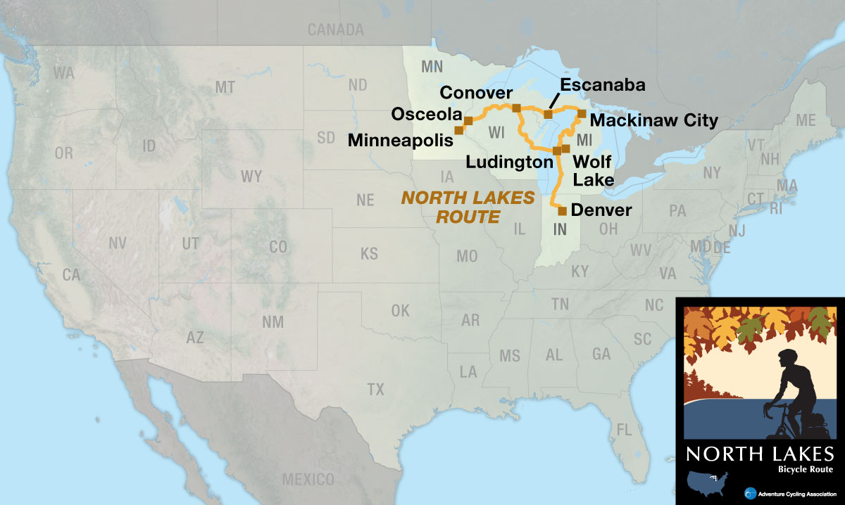
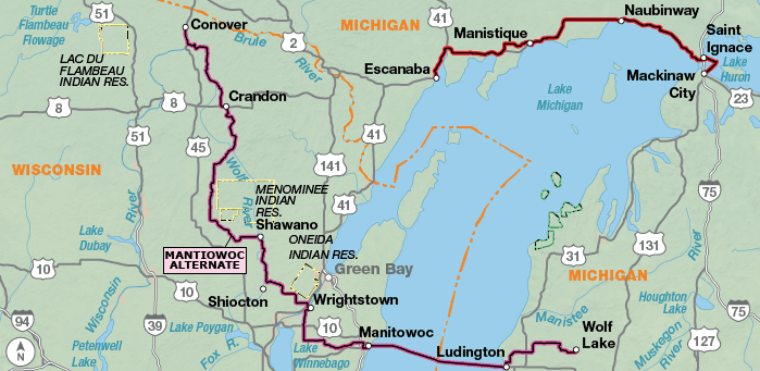
The North Lakes Bicycle Route is very pleasant to ride if you like biking through hardwood forests, lakes and farmlands. Its beauty is subtle rather than dramatic. It’s a route in which high-mileage days are possible, if you are so inclined, because it is not particularly difficult. If you are doing the Northern Tier, you can use sections one, two and three along with the Lake Erie Connector to stay north instead of dropping south and going through Iowa, Illinois, Indiana, and Ohio. The Manitowoc Alternate uses a ferry across Lake Michigan and shortens the route by about 200 miles. The ferry is pricey, so call for more information before you decide to ride the alternate.

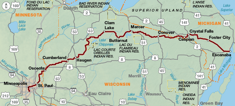
The route begins just outside the Minneapolis-St. Paul International Airport. It uses bike paths and city streets and connects to the Gateway State Trail, a beautiful path that leads you out of the Twin Cities metropolitan area. You’ll cross the St. Croix River into Osceola, Wisconsin. The route goes through dairy farmland and makes a gradual transition to the hardwood forests and lakes in the northern part of the state.
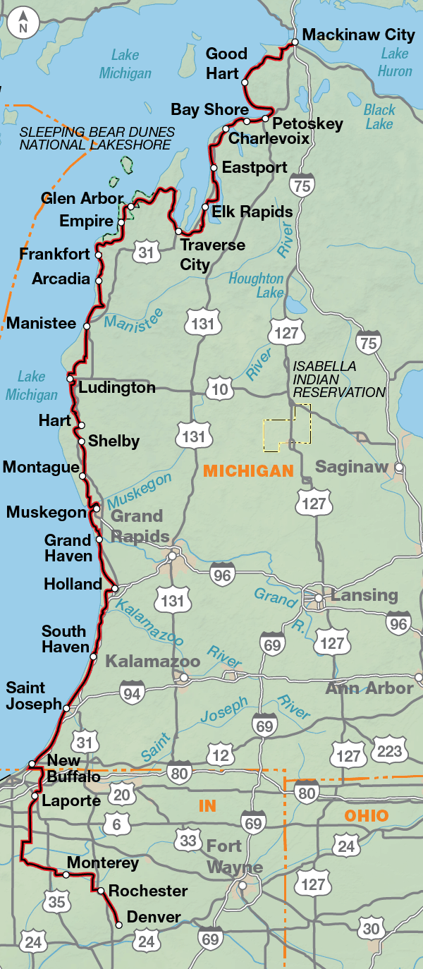
After Wisconsin, you’ll bike through the farmlands of the Upper Peninsula in Michigan and ride alongside Lake Michigan. At St. Ignace, a ferry takes you across the Mackinac Straits into Lower Michigan. But be sure to take some time for a visit on Mackinac Island, and do the short eight-mile loop around the island. You’ll share the road with only horses and buggies, pedestrians, and other bicyclists as motorized vehicles are banned from the island. The area between Mackinaw City and Traverse City, at the northern tip of Lower Michigan, is a favorite spot for vacationing tourists.
South of Harbor Springs, the route is concurrent with U.S. Bicycle Route (USBR) 35, except where noted. Be aware that signs can be damaged, stolen, or otherwise missing so you can never rely totally on following signs. For more information and other maps of the region see www.michigan.gov/mdot-biking.
From Suttons Bay, the route crosses the Leelanau Peninsula to the Sleeping Bear Dunes National Lakeshore. From here going south, you’ll follow rural roads and state highways through small vacation towns along the Lake Michigan shore. Please be cautious of tourist traffic during summer months.
At New Buffalo, the route leaves Lake Michigan on rural roads across Indiana farmland to Denver, finishing on the Nickel Plate Trail. From here, you can rejoin the Northern Tier heading east or west.
Photo by Dennis Coello
The North Lakes Route is generally rolling and one of Adventure Cycling’s easier routes to ride. There are no dramatic climbs over mountain passes. This is not to say that there aren’t any short, steep climbs, but difficult climbing is not the general terrain of this route.
| North Lakes - Main Route | ||||
|---|---|---|---|---|
| Section | Distance | Elevation | Total Climb | Avg. Climb/mile |
| Total | 1159.5 miles | Minimum: 580 ft.Maximum:1860 ft. | 31,245 ft. south bound31,120 ft. north bound | 27 ft. per mi. south bound27 ft. per mi. north bound |
| 1 | 439.5 miles | Minimum: 600 ft.Maximum:1845 ft. | 16,130 ft. south bound16,330 ft. north bound | 37 ft. per mi. south bound37 ft. per mi. north bound |
| 2 | 151.0 miles | Minimum: 580 ft.Maximum:800 ft. | 2,410 ft. south bound2420 ft. north bound | 16 ft. per mi. south bound16 ft. per mi. north bound |
| 3 | 569.0 miles | Minimum: 580 ft.Maximum:950 ft. | 14,550 ft. south bound14,350 ft. north bound | 26 ft. per mi. south bound25 ft. per mi. north bound |
| North Lakes Alternates | ||||
|---|---|---|---|---|
| Name | Section | Distance | Total Climb | Avg. Climb/mile |
| North Lakes Alternates | 2 | 296.5 miles | 8,035 ft. south bound8,755 ft. north bound | 27 ft. per mi. south bound30 ft. per mi. north bound |
The North Lakes Bicycle Route can be ridden from late spring to mid-fall (typically May to September). Due to changing local conditions, it is difficult to predict any major wind patterns. Summer temperatures can be cool.
Services are generally plentiful. There are some especially nice campgrounds and resorts in northern Wisconsin where people like to spend their vacations “at the lake.” Some cyclists may want to do this route during the colors of autumn. If you do, call ahead to verify campgrounds because many close after Labor Day. If staying indoors, make advance reservations.
Some campgrounds will charge a cyclist traveling by himself less if they have hiker/biker sites, but often they will charge the price of a regular tent or RV site, and that can easily be $10-$30/night. The maps list churches that have opened their doors to cyclists, but they aren’t all that closely spaced. If you’re friendly and ask around, you can often get yourself invited to camp in a yard. Our routes sometimes go through national forests (moreso in the west) and you are allowed to camp anywhere on national forest land as long as you “pack it in, pack it out.” Many city parks are free to camp in.
You may also wish to sign up with Warmshowers, a reciprocal hospitality site for bicycle travelers, for other overnight options.
Route Highlights
North Lakes Highlights
- Interstate State Park, Section 1
- Minneapolis and St. Paul, Section 1
- Michigan’s Upper Peninsula, Section 2
- Mackinac Island, Section 2
- Tunnel of Tress, Section 3
- Sleeping Bear Dunes, Section 3
- LaPorte, Indiana, Section 3
More Route Resources
- U.S. Bicycle Route System
- No-Turn-Away Bike Camping Policies (Michigan, Minnesota, Wisconsin)
- Minnesota DOT bike maps
- Minneapolis and St. Paul Twin Cities bike map (Minnesota)
- Access to Minneapolis/St. Paul International Airport (Minnesota)
- Minneapolis/St. Paul light rail (Minnesota)
- Gateway State Trail (Minnesota)
- Wisconsin DOT bike maps
- St. Croix Falls trail map (Wisconsin)
- Gandy Dancer Trail (Wisconsin)
- Heart of Vilas County & Crystal Lake Bike Trails (Wisconsin)
- Wolf River State Trail (Wisconsin)
- Mountain-Bay State Recreation Trail (Wisconsin)
- SS Badger Ferry across Lake Michigan
- U.S. Bicycle Route 20 & 35 (Michigan)
- Michigan DOT bike maps
- Mackinac Bridge crossing (Michigan)
- Shepler’s Mackinac Island Ferry (Michigan)
- Star Line Ferry Mackinac Island Ferry (Michigan)
- Little Traverse Wheelway (Michigan)
- TART Trail (Michigan)
- Hart Montague Trail (Michigan)
- Muskegon Lakeshore Trail (Michigan)
- U.S Bicycle Route 35 (Indiana)
- North Judson Erie Trail (Indiana)
- Nickel Plate Trail (Indiana)
- Connect and share photos with other riders on Instagram: #acaNoLakes
Updates to Recently Released Maps
If you are planning a bike tour, be sure to get the most recent map updates and corrections for your route by selecting the route, and the appropriate section(s), from the drop-down menu below.
Over time maps become less useful because things change. Every year Adventure Cycling’s Routes and Mapping Department create map updates and corrections for every map in the Adventure Cycling Route Network, which now totals 52,047 miles. With the help of touring cyclists like you, we receive updates on routing, services, camping, and contact information. Until we can reprint the map with the new information, we verify the suggested changes and publish corrections and updates here on our website.
PLEASE NOTE: Covid has been particularly hard on the small businesses along our routes. While we do our best to keep the maps and these online updates current, you may encounter more closed businesses and longer stretches with limited or no services.
Refer to these updates for the most current information we have and submit reports of changes to the Route Feedback Form for the cyclists coming after you.
NOTE: Map updates and corrections only pertain to long term changes and updates. For short term road closures, please see the Adventure Cycling’s Routes Temporary Road Closures discussion in our Forums.