Western Express

Western Express San Francisco, CA to Pueblo, CO 4 Map Set GPX Data | Overview | Buy | Mobile App
1. San Francisco, CA to Fallon, NV Detail
2. Fallon, NV to Cedar City, UT Detail
3. Cedar City, UT to Dolores, CO Detail
4. Dolores, CO to Pueblo, CO Detail

All aboard for scenery and adventure.

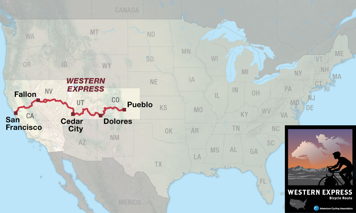
The Western Express Bicycle Route connects San Francisco, California, on the west coast to the TransAmerica Bicycle Trail in Pueblo, Colorado. It provides a shorter mileage option (468 miles less when compared to the TransAmerica Trail) on a central cross-country route but challenges the rider with extreme weather and riding conditions, as well as logistical obstacles. One’s efforts are rewarded, however, by experiencing some of the least visited and most magnificent areas of the American West.

From the metropolis of San Francisco, the Western Express Route passes through lush agricultural valleys and climbs over the Sierra Nevada. In Nevada it uses “The Loneliest Road in America,” a term coined some years ago by a Life magazine writer for U.S. Highway 50. The route then winds among the magnificent monuments and parks of southern Utah. It crosses the spine of the Rocky Mountains over numerous passes to end in Pueblo, Colorado, the gateway to the Great Plains.

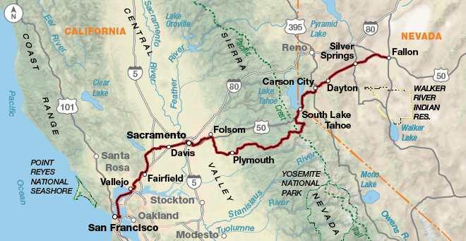
After the food and fun of San Francisco by the Bay, a relaxing ferry ride eliminates a hard day of urban cycling and deposits the cyclist in Vallejo. The route parallels an interstate and winds through suburbs to Fairfield and then passes through rolling, verdant agricultural areas before turning east. Urban riding conditions prevail along the section from Davis through Folsom. Separate bike paths, which start in Davis and extend through Sacramento to Folsom, provide welcome relief from busy surface streets. From there the route begins to climb the Sierra Nevada foothills to the 8,573 foot Carson Pass. It then descends into the historic mining region around Carson City, Nevada.

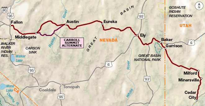
People watchers will enjoy a casino visit in Carson City, assuming you don’t plan to finance your trip there. Just west of South Lake Tahoe, the route joins U.S. Highway 50 into Fallon, where the challenging part really begins. A dozen climbs await the rider on “The Loneliest Road in America” as it traverses the roller-coaster range and basin country paralleling the route of the famous Pony Express. Nevadans are noted for their self-reliance, hospitality (as long as you are not a federal employee), and whimsical sense of humor as evidenced by such unique attractions as the “Post Impressionist ” (fence post) art between Baker and Lehman Cave in Great Basin National Park.

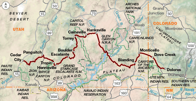
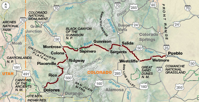
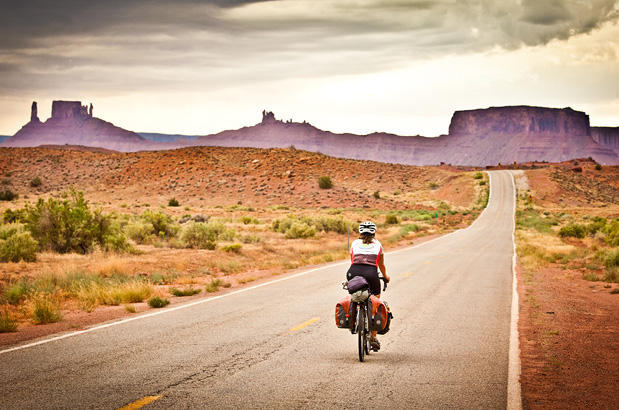
East of Cedar City, Utah, the route passes through some of the nation’s most isolated communities and several of its most spectacular scenic wonders. Take some time to explore Cedar Breaks, Escalante, and Natural Bridges National Monuments; Bryce Canyon and Capitol Reef National Parks; and Glen Canyon National Recreation Area. To even the most experienced of travelers, these natural sculptures, spires, buttes, and canyons are no less than humbling. The Utah portion of the route could be a worthy destination in itself. After passing through the bean-growing capital of the nation in southwestern Colorado, the route swings north and then east through the small tourist communities of the Rockies where one can always find an espresso and a ski hill, however modest. The route traverses forested mountains to Salida and from there into the narrow valley of the Arkansas River to Cotopaxi. Here the route leaves busy U.S. Highway 50 and winds through quiet wooded foothills until reaching Pueblo.

Photo by Adam Coppola

The route lets you warm up for 150 miles before the first major climb over Carson Pass at 8,573 feet. Nevada offers almost unlimited sight lines across wide valleys before ascending and descending a pass into the next valley. The terrain through central Utah becomes steeper, with grades varying from 6 percent to 14 percent. In Colorado the route follows several river valleys, though for the most part you’ll be either climbing or descending.

Western Express - Main Route
Section Distance Elevation Total Climb Avg. Climb/mile
Total 1577.0 miles Minimum: 0 ft.
Maximum:11,320 ft.
103,075 ft. east bound
98,320 ft. west bound
65 ft. per mi. east bound
62 ft. per mi. west bound
1 319.9 miles Minimum: 0 ft.
Maximum:8,595 ft.
20,190 ft. east bound
16,290 ft. west bound
63 ft. per mi. east bound
51 ft. per mi. west bound
2 458.4 miles Minimum: 3,890 ft.
Maximum:7,720 ft.
22,970 ft. east bound
21,035 ft. west bound
50 ft. per mi. east bound
46 ft. per mi. west bound
3 441.4 miles Minimum: 3,705 ft.
Maximum:10,600 ft.
35,225 ft. east bound
34,190 ft. west bound
80 ft. per mi. east bound
77 ft. per mi. west bound
4 357.3 miles Minimum: 4,650 ft.
Maximum:11,320 ft.
24,690 ft. east bound
26,805 ft. west bound
69 ft. per mi. east bound
75 ft. per mi. west bound
Western Express Alternates
Name Section Distance Total Climb Avg. Climb/mi
Carroll Summit Alternate 2 57.9 miles 4,015 ft. east bound
2,910 ft. west bound
69 ft. per mi. east bound
50 ft. per mi. west bound

This route can be ridden from mid-May through October, depending on weather. Carson Pass crosses over the Sierra Nevada at an elevation of 8,573 feet. Local conditions and mountain ranges affect winds, so it is difficult to predict any major wind patterns. Dust and sandstorms will occasionally occur in the deserts of Nevada and Utah. Sections 2 and 3 of this route (Nevada and Utah) are considered difficult due not only to steep terrain but also due to lack of water, temperature extremes (as high as 100 degrees Fahrenheit in the summer), and long mileages without services. >Snow can also fall at any time in the Rocky Mountains, and the highest pass is over 11,000 feet in Colorado.

While California is almost urban in availability of services, Nevada and Utah present special problems in obtaining water and food on a daily basis. Carrying a water filter is strongly advised for water access at miscellaneous reservoirs, creeks, and lakes at primitive campsites. In most cases, there are no homes or ranches between services. Call ahead to verify any services. Nevada and Utah are extremely dry, and few trees are available for shade. In Colorado, services are more easily found, though higher altitude services — from campground water to grocery stores — can close early depending on weather.

Some campgrounds will charge a cyclist traveling alone less if they have hiker/biker sites, but often they will charge the price of a regular tent site, and that can easily be $10-$20/night. The maps list churches that have opened their doors to cyclists, but they aren’t all that closely spaced. If you’re friendly and ask around, you can often get yourself invited to camp in a yard. Our routes sometimes go through national forests (moreso in the west) and you are allowed to camp anywhere on national forest land as long as you “pack it in, pack it out.” Many city parks are free to camp in.

You may also wish to sign up with Warmshowers, a reciprocal hospitality site for bicycle travelers, for other overnight options.


Route Highlights

Western Express Highlights

  • Golden Gate National Recreation Area, Section 1
  • U.S. Bicycle Hall of Fame, Section 1
  • Great Basin National Park, Section 2
  • Cedar Breaks National Monument, Section 3
  • Bryce Canyon National Park, Section 3
  • Grand Staircase-Escalante National Monument, Section 3
  • Capitol Reef National Park, Section 3
  • Glen Canyon National Recreation Area, Section 3
  • Natural Bridges National Monument, Section 3
  • Canyon of the Ancients National Monument, Section 3
  • Telluride, Colorado, Section 4
  • Monarch Pass, Section 4
  • Black Canyon of the Gunnison National Park, Section 4

More Route Resources


RIDING CONDITIONS

On this section of the route you will encounter a wide variety of riding conditions from urban to rural while using state highways, county roads and separate bike paths. Many roads will have wide shoulders while others will have none. Be prepared for numerous distractions riding through downtown San Francisco. For maps and other resources contact the San Francisco Bicycle Coalition: www.sfbike.org.

After taking the ferry across the bay to Vallejo, there will be more urban cycling. The farther the route heads eastward into the central valley, the more you’ll encounter pockets of residential areas interspersed with agricultural land and moderate levels of traffic.

The route enters Davis, widely known as the “Bicycle Capital of the World,” on separate paths skirting the edge of the UC Davis campus. Maps and more information about cycling in Davis is available at: advcy.link/davismap.

In Sacramento the route uses a large portion of the multi-use Jedediah Smith National Recreation Trail (also known as the America River Bike Trail). Restrooms and picnic spots are located along this scenic corridor. You can find an interactive map of the trail at advcy.link/jedsmtrl.

The route east of Folsom begins climbing into the Sierra Nevada. Leaving Plymouth, the route uses smaller roads with little and sometimes no shoulder through vineyard country. Commuters use these roads, so avoid them during the morning and evening rush hours. Traffic increases on weekends.

State Highway 88 is a recreation corridor, so expect traffic during summer months and especially on weekends. It is narrow, has minimal shoulders and many turn-outs. The climb and descent over Carson Pass is steep.

U.S. Bicycle Route (USBR) 50 has been designated in Nevada. Portions of our route run concurrent with it. For more information and maps see: advcy.link/nvusbr50.

U.S. Highway 50 to South Lake Tahoe mostly has reasonable shoulders but sometimes shrink. There can be a high volume of recreational traffic. Ride with caution.

The Great Basin country is east of the Sierra Nevada. Buy any spare parts for your bike in Carson City as you’ll find few bike shops in Nevada and Utah. Traffic decreases as you head east to Fallon on U.S. Highway 50, where it begins to resemble its nickname as the “Loneliest Road in America.”

CLIMATE

Summer is a dry period over most of California. Areas that are well protected from the ocean experience a more continental type of climate with warmer summers, colder winters, greater daily and seasonal temperature ranges, and generally lower relative humidities. The San Francisco Bay area has many varieties of climate within a few miles due to the influence of topography on the circulation of marine air. The Coast Range and Sierra Nevada offer some protection to the interior from the strong flow of Pacific air. Thunderstorms may occur at any time of the year, and are usually light and infrequent. But they may become unusually strong on occasion at intermediate and high elevations in the Sierra Nevada.

Updated: Apr 4, 2019


RIDING CONDITIONS

U.S. Bicycle Route (USBR) 50 has been designated in Nevada. Portions of our route run concurrent with it. For more information and maps see advcy.link/nvusbr.

The route in Nevada, along U.S. Highway 50, was described some years ago by a Life magazine writer as “The Loneliest Road in America.” You’ll see occasional vehicles on the road but towns and services are spaced, in some instances, a long day’s ride apart. In most cases there are no homes or ranches between services. The maps note where the longest stretches without services are so plan your days accordingly.

This section of the Western Express Route is considered very difficult due not only to terrain, but also due to lack of water, temperature extremes, and long mileages without services. Carrying a water purifier is strongly advised for any water access outside of towns. Nevada is extremely dry and has limited shade to duck away from the sun.

The surface of the highways in Nevada and Utah are fair to excellent, but shoulder widths vary. U.S. 50’s shoulders have deep rumble strips, usually centered in the middle of the shoulder, making them almost useless for bicyclists. When this route was first published in 2001, traffic volumes were minimal. Since then they have grown and vehicles continue to pass at high speeds. Make yourself and your bike as visible as possible and stay aware of conditions.

Sand Mountain, located north of the Sand Springs Pony Express Station between Fallon and Middlegate, is a popular weekend and holiday destination for 4-wheelers. Traffic will likely be heavy at those times.

Between Middlegate and Austin the Carroll Summit Alternate is 1 mile shorter than the main route. The climb and descent over Carroll Summit is higher than the passes on the main route, but shade in the Desatoya Mountains offers a change of scenery and welcome respite from the rest of the route along this section.

Near and in any national park cyclists will have to contend with higher traffic levels and RV drivers who are inexperienced. To avoid heavy traffic try to ride early in the day and make yourself and your bike visible.

U.S. Bicycle Route (USBR) 79 is signed throughout Utah. Our routing is not always concurrent with USBRs. For more information and maps see advcy.link/utusbr. Be aware that signs can be damaged, stolen, or otherwise missing so you can never rely totally on following signs.

Between Minersville and Cedar City on SR 130 there is heavy commuter traffic in the mornings and evenings. In many spots there aren’t any shoulders. Please make sure you are visible.

There are three long stretches without any services. They are between Austin and Eureka (69.6 miles), Eureka and Ely (78 miles), and between Baker, Nevada and Milford, Utah (83.1 miles). Make sure you carry enough water and don’t get dehydrated.

CLIMATE

In Nevada and western Utah there is relatively strong insolation of heat during the day and rapid nighttime cooling, because of the clear air, resulting in wide daily ranges in temperature. Even after the hottest days, the nights are usually cool.

Mountain snowfall is the main source of water for streamflow. In years when winter and spring snowfall is light, the result is a shortage of water.

Summer thunderstorms develop occasionally into heavy local downpours of rain. These storms, locally termed cloudbursts, may bring to a locality as much rain in a few hours as would normally fall in several months. The low humidity and abundant sunshine produce rapid evaporation.

Winds are generally light. The prevailing wind direction is west and dust and sandstorms occur occasionally.

Updated: Apr 7, 2020


RIDING CONDITIONS

This section of the Western Express Route is considered very difficult due not only to terrain (grades from 6% to 14%), but also due to lack of water, temperature extremes, and long mileages without services. In most cases, there are no homes or ranches between services. Carrying a water purifier is strongly advised for water access at Lake Powell and for miscellaneous reservoirs, creeks, and lakes at primitive campsites. Utah is extremely dry and most of the route has only rocks for shade. Note that the only bike shops on this section are in Cedar City and Dolores, with the exception of limited gear and repairs in Monticello.

U.S. Bicycle Route (USBR) 70 is signed throughout Utah. Our routing is not always concurrent with USBRs. For more information and maps see advcy.link/utusbr. Be aware that signs can be damaged, stolen, or otherwise missing so you can never rely totally on following signs.

All the paved highways have fair to excellent surfaces, but shoulder widths vary from 0 to 8 feet. During tourist season and near national parks, beware of RVs and other traffic when the highway grades are steep and sight lines are limited. To avoid heavy traffic, try to ride early in the day and make yourself and your bike visible. Throughout the national forests you might encounter logging trucks also.

In Utah all the roads have cattleguards across them at odd places, and most often they are unmarked. Occasionally you’ll see a black and yellow pole at a cattleguard in warning. Cross these with caution.

This section has some of the most spectacular scenery in America available along paved roads and provides access to a large number of national parks, monuments, and state parks. Take some extra time to explore and do some hiking and biking into the off-route parks.

Heading east from Cedar City there is a long, steep climb of 20 miles. SR 148 through Cedar Breaks National Monument is closed during the winter months, from the end of October until mid- to late-May. Iron County Tourism (800-354-4849) will know actual opening and closing dates. When SR 148 is closed, USBR 70 is suggested as an alternate.

The Hogback south of Boulder is a highlight (or terror) of the area. It is a 2-mile stretch of narrow two-lane road along a ridge spine with no shoulders or guardrails and has drops on both sides. Ride carefully and defensively.

At the Fruita Historic District in Capitol Reef National Park you can pick ripening fruit for a snack between June and October.

In eastern Utah, services and water are very limited and sometimes off the route. From Hanksville to Blanding (125 miles) services are especially sparse so plan your days carefully. Call ahead to confirm services on Lake Powell at the Hite Outpost and nearby Hite Ranger Station.

NOTE: After October 1, many private and USFS campgrounds close for the winter or have no water available. Call ahead to verify conditions if you are traveling after this date.

CLIMATE

Temperatures over 100°F occur occasionally in summer in nearly all parts of Utah. However, low humidity makes these high temperatures more bearable. Even after the hottest days, nights are usually cool. On clear nights the colder air acculumates, by drainage, on the valley bottoms, while the foothills and bench areas remain relatively warm. Sunny skies prevail most of the year.

The prevailing westerly air currents that reach Utah and western Colorado are comparatively dry, resulting in light precipitation over most of the state. Thunderstorm season is from July through September and brings cloudbursts, lightning, and occasional isolated flash floods.

Updated: Apr 7, 2020

Updates to Recently Released Maps

If you are planning a bike tour, be sure to get the most recent map updates and corrections for your route by selecting the route, and the appropriate section(s), from the drop-down menu below.

Over time maps become less useful because things change. Every year Adventure Cycling’s Routes and Mapping Department create map updates and corrections for every map in the Adventure Cycling Route Network, which now totals 52,047 miles. With the help of touring cyclists like you, we receive updates on routing, services, camping, and contact information. Until we can reprint the map with the new information, we verify the suggested changes and publish corrections and updates here on our website.

PLEASE NOTE: Covid has been particularly hard on the small businesses along our routes. While we do our best to keep the maps and these online updates current, you may encounter more closed businesses and longer stretches with limited or no services.

Refer to these updates for the most current information we have and submit reports of changes to the Route Feedback Form for the cyclists coming after you.

NOTE: Map updates and corrections only pertain to long term changes and updates. For short term road closures, please see the Adventure Cycling’s Routes Temporary Road Closures discussion in our Forums.