Tidewater Potomac

Due to limited resources, the paper map version of this route has been discontinued. This route is still available digitally.
Ride through American history and natural wonders.
The Tidewater Potomac Heritage Bicycle Route introduces the cyclist to an area rich in scenic beauty, ecological diversity, and early American colonial history. Museums and points of interest give ample opportunities for sightseeing. Several historic sites are connected to George Washington, the father of the U.S. They include Mt. Vernon, George Washington’s Ferry Farm, where he lived from age six until early adulthood, and the George Washington Birthplace National Monument.
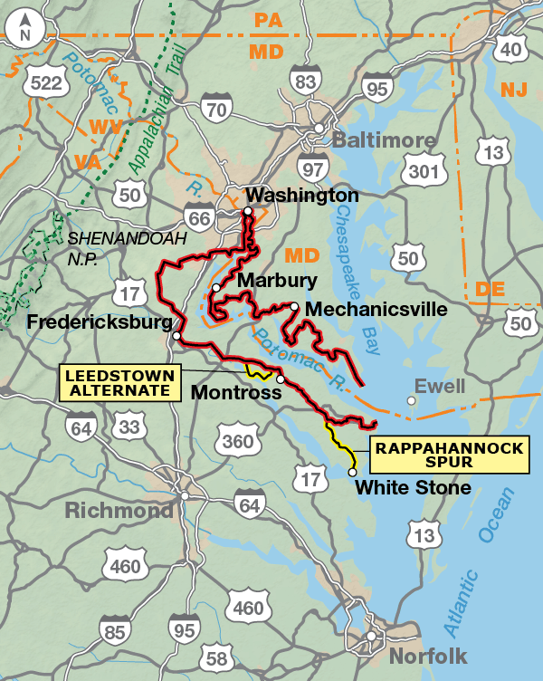
This route lies within a portion of the Potomac Heritage National Scenic Trail corridor. The route begins in Washington, D.C., and traverses both sides of the Potomac River in Maryland and Virginia until it reaches the Chesapeake Bay. At this time it’s best if you reverse your route rather than attempt a loop by crossing the Chesapeake Bay. Due to the rising costs of fuel, both cruise companies listed in the map’s Riding Conditions only run the ships if they have enough passengers registered for the trip (15 minimum) and even then it usually only runs on Saturday and Sunday. Unfortunately, these circumstances cause the ship to be canceled most days.
This route begins and ends at Union Station in Washington, D.C. A spur route within the city is also shown to connecting to the eastern terminus of the C & O Canal Towpath for those cyclists who may want to continue up the Potomac River. The route crosses the Potomac and heads into Virginia along the Mt. Vernon Trail. You’ll have to pedal approximately forty miles before leaving the suburbs behind and getting into the rural countryside. The route skirts the Quantico Marine Corps Reservation on its way to Fredericksburg. This town has its share of museums and historic sites, so plan to spend a day sightseeing.
Leaving Fredericksburg, you’ll head eastward into the peninsula known as the Northern Neck. Traffic decreases the farther east you go, and it’s pleasant riding on smaller back roads. Stratford Hall Plantation, the birthplace of Robert E. Lee, is located on the Potomac River, and there are several museums to visit in the small towns along the route. If you want to explore further, there’s a 25-mile spur to the Rappahannock River bridge.
The route in Maryland meanders along smaller roads through fields and woods. There are many points of interest, museums, and state parks to visit along the way, so plan your days accordingly. Nearby towns offer full services. Automobile traffic increases the closer you get to the Washington area. You will need city-riding skills as you share the road with traffic entering the District of Columbia.
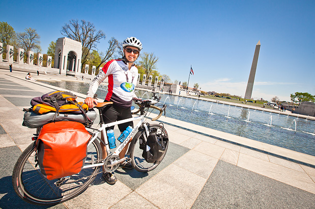
Photo by Adam Coppola
The District of Columbia, Virginia, and Maryland have flat to rolling topography. A few short hills will be encountered. Rivers and bays create fingers of land called “necks,” and the route dips down into the necks, allowing easy access to points along the Potomac River.
| Tidewater Potomac - Main Route | ||||
|---|---|---|---|---|
| Section | Distance | Elevation | Total Climb | Avg. Climb/mile |
| Total | 377.0 miles | Minimum: 0 ft.Maximum:430 ft. | 14,095 ft. clockwise14170 ft. counterclockwise | 37 ft. per mi. clockwise38 ft. per mi. counterclockwise |
| Tidewater Potomac Alternates | ||||
|---|---|---|---|---|
| Name | Section | Distance | Total Climb | Avg. Climb/mile |
| Leedstown Alternate | 1 | 17.5 miles | 500 ft. counterclockwise495 ft. clockwise | 29 ft. per mi. counterclockwise28 ft. per mi. clockwise |
| Rappahannock Spur | 1 | 25.0 miles | 540 ft. south bound655 ft. north bound | 22 ft. per mi. south bound26 ft. per mi. north bound |
| C&O Canal Alternate | 1 | 1.2 miles | 25 ft. north bound15 ft. south bound | 21 ft. per mi. north bound13 ft. per mi. south bound |
The lower Potomac River region has considerably warm weather and humidity during the summer months. Otherwise it may be ridden from early spring to late fall (typically April to October). Only privately owned cruise ship companies cross the Chesapeake Bay, so working within their schedule is a must if you want to cross the bay. Occasionally delays can occur due to inclement weather, so be prepared.
Due to the rising costs of fuel, both cruise companies listed in the map’s Riding Conditions only run the ships if they have enough passengers registered for the trip (15 minimum) and even then it usually only runs on Saturday and Sunday. Unfortunately, these circumstances cause the ships to be canceled most days.
Another option for crossing the Chesapeake Bay between Smith Point and Point Lookout is to hire a private fishing boat to ferry you across. Captain Danny Crabbe of Crabbes Charter Fishing has been offering this service to cyclists for years. You’ll need to call ahead and make reservations.
All services and bike shops can be found in Washington and in the cities and suburbs nearby. Fredericksburg also has bike shops. When you leave the suburbs and ride into more rural areas, services will be less plentiful, though small towns with the basic convenience stores appear frequently.
Some campgrounds will charge a cyclist traveling alone less if they have hiker/biker sites, but often they will charge the price of a regular tent or RV site, and that can easily be $10-$40/night. The maps list churches that have opened their doors to cyclists, but they aren’t all that closely spaced. If you’re friendly and ask around, you can often get yourself invited to camp in a yard. Our routes sometimes go through national forests (moreso in the west) and you are allowed to camp anywhere on national forest land as long as you “pack it in, pack it out.” Many city parks are free to camp in.
You may also wish to sign up with Warmshowers, a reciprocal hospitality site for bicycle travelers, for other overnight options.
Route Highlights
Tidewater Potomac Highlights
- Numerous national and historic sites in Washington D.C.
- Chesapeake Bay
- Arlington National Cemetery
- Mt. Vernon, home of George Washington
- Kenmore Plantation and Gardens
- George Washington’s Ferry Farm
- Fredericksburg Spotsylvania National Battlefield
- Northern Neck of Virginia
- George Washington Birthplace
- Stratford Hall Plantation
- St. Clelments Island Potomac River Museum
- Thomas Stone National Historic Site
- National Colonial Farm Museum
- Fort Washington National Park
- Oxon Hill Farm
More Route Resources
- Washington Area Bicyclist Association (D.C. area trail maps)
- U.S. Bicycle Route 1 (Virginia)
- Virginia DOT Bicycle/Pedestrian Program
- Virginia Bicycling Federation
- Crabbe’s Charter Fishing (Chesapeake Bay crossing)
- Smith Island Cruises
- Maryland DOT Bicycle/Pedestrian Program
- Maryland DOT Interactive Bicycle Map
- Connect and share photos with other riders on Instagram: #acaPotomac
Updates to Recently Released Maps
If you are planning a bike tour, be sure to get the most recent map updates and corrections for your route by selecting the route, and the appropriate section(s), from the drop-down menu below.
Over time maps become less useful because things change. Every year Adventure Cycling’s Routes and Mapping Department create map updates and corrections for every map in the Adventure Cycling Route Network, which now totals 52,047 miles. With the help of touring cyclists like you, we receive updates on routing, services, camping, and contact information. Until we can reprint the map with the new information, we verify the suggested changes and publish corrections and updates here on our website.
PLEASE NOTE: Covid has been particularly hard on the small businesses along our routes. While we do our best to keep the maps and these online updates current, you may encounter more closed businesses and longer stretches with limited or no services.
Refer to these updates for the most current information we have and submit reports of changes to the Route Feedback Form for the cyclists coming after you.
NOTE: Map updates and corrections only pertain to long term changes and updates. For short term road closures, please see the Adventure Cycling’s Routes Temporary Road Closures discussion in our Forums.