Grand Canyon Connector
Riding along a World Heritage Site.
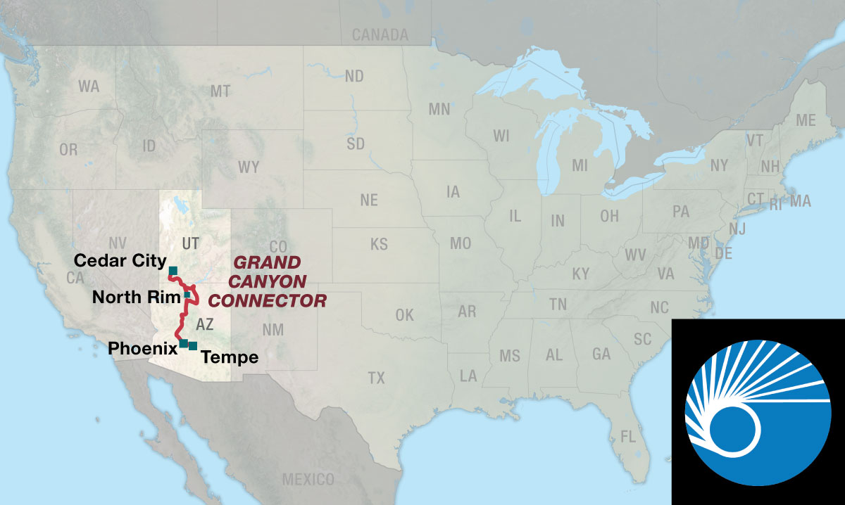
The Grand Canyon Connector, which connects the Western Express Route and the Southern Tier, guides cyclists through a prime section of the vast and beautiful American West. It also connects the magnificent Zion National Park and both sides of Grand Canyon National Park. From the Western Express Route, it offers the opportunity to access Zion National Park and the north rim of the Grand Canyon. From Tempe on the Southern Tier Route, it is 265.4 miles to reach the south rim of the Grand Canyon. One of the most spectacular examples of erosion anywhere in the world, the Grand Canyon is unmatched in the vistas it offers to visitors on the rim. Grand Canyon National Park is a World Heritage Site.
Some portions of the Grand Canyon Route are very remote, so good planning is needed for basics like food and water. The redrock country of Utah and the Grand Canyon are beautiful and unique to this area of the country. The elevational differences range from the Sonoran Desert up through the ponderosa pine and aspen forests in Arizona to the high desert and pinyon-juniper forests of Utah. Be prepared for occasional blowing dust storms in the lower desert regions. Local conditions and mountain ranges affect winds, so it is difficult to predict any major wind patterns. Expect heavy traffic levels during the tourist season (generally July through Labor Day). An ideal time for both weather and lighter tourist traffic is in the early fall. If camping out, be aware that scorpions may have gathered under your tent floor during the night. Rattlesnakes also tend to be near water sources in the mornings.
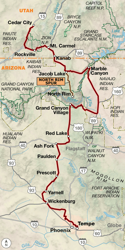
The Connector begins in Cedar City, Utah, which is the beginning and end points on Sections 2 and 3 of the Western Express Route. Both Zion and Grand Canyon National Parks are bicycle-friendly, allowing cyclists to ride in popular sections where visitors in automobiles must use shuttle buses during the main tourist season. It is wise to visit with rangers at the park entrance stations. Bicyclists are not allowed to ride through the longer 1-mile Zion-Mt. Carmel tunnel in Zion National Park. You must ask for a ride from another vehicle on the road, preferably from a pick-up where you can put your bicycle in the back. The two rims of Grand Canyon National Park differ significantly, but both are appealing. The south rim is much more developed, has more services, and because of its accessibility is more heavily visited. The north rim is more remote, higher in elevation, and offers full but fewer services. The 44.3-mile spur to the north rim is a beautiful ride but does require backtracking to rejoin the main route. The route between the two rims of the Grand Canyon is the most remote section and offers a unique experience to the adventurous cyclist. Much of this lies on the Navajo Nation, allowing opportunities to meet these Native American people. Services are limited to several trading posts that sell groceries and water. The trading posts also offer authentic Navajo-made crafts, pottery, and weavings as well as some rich history of their culture. Alcohol is not sold or served anywhere within the Nation. Wickenburg, near the southern end of the route, is the connecting point to the Southern Tier Route. This route continues into the metropolitan area surrounding Phoenix and ends in Tempe, near the international airport.
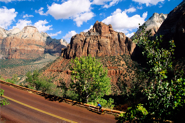
Photo by Dennis Coello
This route comprises a series of climbs and descents. The elevation differences range from low desert to high desert. Within these elevation zones, there are some impressive climbs and steep drops for the touring cyclist. The route begins at 5,843′ and ends at 1,198′, with several climbs/descents over 7,000′. The North Rim Spur has the highest elevation, at over 8,500′, for a length of 27 miles.
| Grand Canyon Connector - Main Route | ||||
|---|---|---|---|---|
| Section | Distance | Elevation | Total Climb | Avg. Climb/mile |
| Total | 569.5 miles | Minimum: 1,140 ft.Maximum:7,925 ft. | 29,930 ft. south bound35,455 ft. north bound | 53 ft. per mi. south bound62 ft. per mi. north bound |
| Grand Canyon Connector Alternates | ||||
|---|---|---|---|---|
| Name | Section | Distance | Total Climb | Avg. Climb/mile |
| North Rim Spur | 1 | 43.4 miles | 2,545 ft. south bound2,290 ft. north bound | 59 ft. per mi. north bound53 ft. per mi. north bound |
This route can be ridden from spring through fall (typically April/May to October), with spring having the most widely changing weather conditions. Summers are potentially hot, with high temperatures sometimes above 100F, so be prepared to rest during the heat of the day. Be aware that snow can fall at any time in the higher elevations along the route.
Services are generally well spaced along the connector, but bicycle shops are limited to the larger communities. In the national parks, plan to make reservations or arrive early in the day to secure camping spots.
Some portions of the Grand Canyon Route are very remote, so good planning is needed for basics like food and water.
Some campgrounds will charge a cyclist traveling alone less if they have hiker/biker sites, but often they will charge the price of a regular tent or RV site, and that can easily be $10-$40/night. If you’re friendly and ask around, you can often get yourself invited to camp in a yard. Our routes sometimes go through national forests (moreso in the west) and you are allowed to camp anywhere on national forest land as long as you “pack it in, pack it out.” Many city parks are free to camp in.
You may also wish to sign up with Warmshowers, a reciprocal hospitality site for bicycle travelers, for other overnight options.
Route Highlights
Grand Canyon Connector Highlights
- Zion National Park
- Vermilion Cliffs National Monument
- Navajo Bridge Interpretive Center
- Grand Canyon National Park
More Route Resources
- Zion National Park Bicycle Policy
- Utah DOT Seasonal Highway Closures
- U.S. Bicycle Route System
- U.S. Bicycle Route 90 (Arizona)
- Arizona DOT bike maps
- Phoenix Bicycling Maps (Arizona)
- Connect and share photos with other riders on Instagram: #acaGrandCanyon
Updates to Recently Released Maps
If you are planning a bike tour, be sure to get the most recent map updates and corrections for your route by selecting the route, and the appropriate section(s), from the drop-down menu below.
Over time maps become less useful because things change. Every year Adventure Cycling’s Routes and Mapping Department create map updates and corrections for every map in the Adventure Cycling Route Network, which now totals 52,047 miles. With the help of touring cyclists like you, we receive updates on routing, services, camping, and contact information. Until we can reprint the map with the new information, we verify the suggested changes and publish corrections and updates here on our website.
PLEASE NOTE: Covid has been particularly hard on the small businesses along our routes. While we do our best to keep the maps and these online updates current, you may encounter more closed businesses and longer stretches with limited or no services.
Refer to these updates for the most current information we have and submit reports of changes to the Route Feedback Form for the cyclists coming after you.
NOTE: Map updates and corrections only pertain to long term changes and updates. For short term road closures, please see the Adventure Cycling’s Routes Temporary Road Closures discussion in our Forums.