TransAmerica Trail
History of the Trail.
The TransAmerica Bicycle Trail began in 1973, during our co-founder’s ride from Alaska to Argentina, as nothing more than an ambitious idea for a way to celebrate the nation’s upcoming 200th birthday. By June of 1976, the Trail was ready; the maps and guidebooks were published thanks to an enormous effort. Now cyclists were needed to ride it across the country. Given the name “Bikecentennial,” organizers publicized the event and thanks to strong word-of-mouth and its fortunate, prodigious publicity, 4,000 cyclists showed up for the ride.
Most of the riders were in their 20s and had no experience with long-distance cycling. They traveled in groups of 10 to 12 with leaders trained by Bikecentennial. There were few helmets to be seen and the bikes were often discount-store quality.
But the equipment scarcely mattered. This group of people set out to have the experience of a lifetime and for the most part they did, learning about America and about themselves in a profound way.
Indeed, many cyclists who rode across the country in 1976, and those who ride the Trail today, say essentially the same thing about the experience, “I learned more about this country in 90 days than most people learn in a lifetime.”
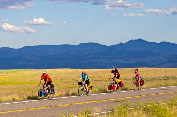
The classic route to cross America by bicycle.
Grand parks along the TransAmerica Trail include Yellowstone and Grand Teton national parks, among the best in the United States. One additional treat: because this route has been ridden by cyclists for years, many of the cafes, restaurants, and overnight accommodations along the route have kept journals consisting of entries written by cross-country riders from previous years, providing you with a cyclist’s history of the route. Plan on around three months (give or take) for the crossing. Some traverse the route quicker, but this leaves less time for sightseeing.
Astoria, Oregon, with the hills of a miniature San Francisco, is the official beginning-of-the-road. The view from atop the Astoria Column is well worth the uphill pedal. Stretches of beaches, outstanding state parks, steep ascents and descents, and great seafood abound during your first days of riding before you turn inland to the Willamette River Valley. Eugene is the largest city along the route. Other sizable cities along the way are Missoula, Montana; Pueblo, Colorado; and Carbondale, Illinois. The lush, green western side of the Cascade Mountains is a startling contrast to the dry terrain you’ll be riding into after McKenzie Pass. The road over McKenzie Pass literally cuts through an ancient lava field and offers spectacular views of the Three Sisters and other snow-capped volcanic peaks of the Cascades. Central and eastern Oregon is made up of dry, mountainous terrain and is good place to carry extra water. The National Historic Oregon Trail Interpretive Center outside of Baker City is a must-see, and after completing your trip crossing the country, you’ll have no trouble relating to the experiences of the early pioneers.
Idaho offers a wonderful ride along the Little Salmon and Salmon rivers, and some interesting Native American historic sites to visit. The route then follows the winding, scenic Middle Fork Clearwater and Lochsa rivers for the longest gradual ascent of the trip (around 70 miles). You’ll climb up and over Lolo Pass, enter Montana, and soon reach the spur into Missoula. Missoula, a college town, provides one of the highlights of the route, featuring Adventure Cycling headquarters with its “cyclist’s lounge” and other amenities, along with whatever services you may require in town. Beautiful panoramas, wide valleys and mountain passes await you in Montana.
The views in Yellowstone National Park and of the Grand Teton Range in Wyoming are incomparable, and memories will last a lifetime. It’s worth an extra day or two off the bike to experience as much as you can of these two phenomenal national parks. Towns such as Dubois and Lander remind you that you’re in the west, with their historic architecture and western-style cooking.
The scenery quickly changes from dry, high desert to alpine as you reach Kremmling, Colorado. Touristy Frisco and Breckenridge in Summit County is another great place for a layover day. You begin a long climb to crest the Continental Divide at Hoosier Pass, 11,542 feet, up amongst snow-covered peaks. As the route leaves the Rockies, Royal Gorge Park offers a fun layover day, either for hanging out at the Arkansas River bridge or taking a helicopter ride over or a raft trip through the gorge. Pueblo offers bike shops and great places to eat; it also serves as the halfway point of the TransAm Trail (time to celebrate!). It’s a good place to stock up – it’s the largest city you’ll pass through until Carbondale, Illinois.
Things start to dry out as you get into the eastern part of Colorado and cross into western Kansas. Carrying extra water is a good idea here – this is hot, barren country. Right around Haswell, Colorado, you’ll see your last hazy glimpse of the Rocky Mountains. Overnights at city parks in Kansas are usually accompanied by cool dips in the city swimming pools. You might have to do some early morning and early evening riding to escape the midday heat. Don’t miss the pies at Cooky’s in Golden City, Missouri! The flat-as-a-pool-table terrain of the Great Plains will change quickly into the roller-coaster riding of Missouri. You’ll find Missouri offers Civil War history, terrific canoeing at Eminence, and an excellent swimming hole at Johnson’s Shut-Ins State Park.
The route crosses the Mississippi River at Chester, Illinois, and heads into Carbondale, another fun college town. A ferry takes you across the Ohio River into Kentucky, where you’ll enjoy the evening fireflies at your campsites. Kentucky offers rolling white-fenced farms and woodlands until reaching Berea, the gateway to the Appalachian Mountains. A loop south of the route will take you to see Mammoth Cave National Park, the longest cave system in the world. Past Berea, you’ll spend some time ascending and descending the mountains of the Appalachians, and riding part of the Blue Ridge Parkway in Virginia. The mountains turn to rolling hills and then flat riding through lush plantations and farmlands. The last stretch of the route is rich in the history of the American Revolution, with Colonial Williamsburg as the highlight. Yorktown, situated on the Chesapeake Bay, is the route’s end.
Photo by Chuck Haney
Some stretches of the western portion of the route follow large river valleys and can be generally flat, but expect some climbing almost every day between Astoria, Oregon, and Pueblo, Colorado. The passes throughout the Rocky Mountains are generally long but not terribly steep. The descents from these passes are, of course, a blast. Most of Kansas is beautifully flat. Missouri through the Ozarks and eastern Kentucky through the Appalachians offers short, steep climbs. You might even have to walk up some hills. The Virginia portion of the route, surprisingly, has more total elevation gain than any other state.
| TransAmerica Trail - Main Route | ||||
|---|---|---|---|---|
| Section | Distance | Elevation | Total Climb | Avg. Climb/mile |
| Total | 4204.9 miles | Minimum: 0 ft.Maximum:11,535 ft. | 216,330 ft. east bound216,495 ft. west bound | 51 ft. per mi. east bound51 ft. per mi. west bound |
| 1 | 224.5 miles | Minimum: 0 ft.Maximum:840 ft. | 9,955 ft. east bound9,400 ft. west bound | 44 ft. per mi. east bound42 ft. per mi. west bound |
| 2 | 341.0 miles | Minimum: 425 ft.Maximum:5,330 ft. | 19,680 ft. east bound16,780 ft. west bound | 58 ft. per mi. east bound49 ft. per mi. west bound |
| 3 | 408.4 miles | Minimum: 1,225 ft.Maximum:5,235 ft. | 23,615 ft. east bound23,900 ft. west bound | 58 ft. per mi. east bound59 ft. per mi. west bound |
| 4 | 329.8 miles | Minimum: 3,120 ft.Maximum:7,420 ft. | 15,645 ft. east bound12,355 ft. west bound | 47 ft. per mi. east bound37 ft. per mi. west bound |
| 5 | 350.0 miles | Minimum: 5,325 ft.Maximum:9,570 ft. | 19,065 ft. east bound19,000 ft. west bound | 54 ft. per mi. east bound54 ft. per mi. west bound |
| 6 | 389.5 miles | Minimum: 4,650 ft.Maximum:11,535 ft. | 20,210 ft. east bound22,310 ft. west bound | 52 ft. per mi. east bound57 ft. per mi. west bound |
| 7 | 287.8 miles | Minimum: 2,080 ft.Maximum:4,730 ft. | 2,310 ft. east bound4,940 ft. west bound | 8 ft. per mi. east bound17 ft. per mi. west bound |
| 8 | 326.1 miles | Minimum: 815 ft.Maximum:2,085 ft. | 5,905 ft. east bound7,015 ft. west bound | 18 ft. per mi. east bound22 ft. per mi. west bound |
| 9 | 411.0 miles | Minimum: 360 ft.Maximum:1,565 ft. | 24,945 ft. east bound25,415 ft. west bound | 61 ft. per mi. east bound62 ft. per mi. west bound |
| 10 | 400.4 miles | Minimum: 325 ft.Maximum:1,030 ft. | 24,110 ft. east bound23,510 ft. west bound | 60 ft. per mi. east bound59 ft. per mi. west bound |
| 11 | 370.5 miles | Minimum: 655 ft.Maximum:3,755 ft. | 31,850 ft. east bound30,760 ft. west bound | 86 ft. per mi. east bound83 ft. per mi. west bound |
| 12 | 365.9 miles | Minimum: 0 ft.Maximum:3,335 ft. | 19,040 ft. east bound21,110 ft. west bound | 52 ft. per mi. east bound58 ft. per mi. west bound |
| TransAmerica Trail Alternates | ||||
|---|---|---|---|---|
| Name | Section | Distance | Total Climb | Avg. Climb/mile |
| Florence Alternate | 1 | 76.4 miles | 2,670 ft. east bound2,340 ft. west bound | 35 ft. per mi. east bound31 ft. per mi. west bound |
| Salem Spur | 1 | 9.8 miles | 235 ft. east bound275 ft. west bound | 24 ft. per mi. east bound28 ft. per mi. west bound |
| Eugene Spur | 1 | 5.8 miles | 95 ft. south bound60 ft. north bound | 16 ft. per mi. south bound10 ft. per mi. north bound |
| Three Capes Scenic Option | 1 | 15.5 miles | 1,045 ft. east bound1040 ft. west bound | 67 ft. per mi. east bound67 ft. per mi. west bound |
| Eugene Spur | 2 | 6 miles | 105 ft. south bound65 ft. north bound | 18 ft. per mi. south bound11 ft. per mi. north bound |
| Santiam Alternate | 2 | 49.0 miles | 4,145 ft. east bound2,635 ft. west bound | 85 ft. per mi. east bound54 ft. per mi. west bound |
| Alternate | 3 | 5.4 miles | 140 ft. east bound75 ft. west bound | 26 ft. per mi. east bound14 ft. per mi. west bound |
| Old Darby Alternate | 4 | 12.9 miles | 610 ft. east bound390 ft. west bound | 47 ft. per mi. east bound30 ft. per mi. west bound |
| Gibbons Pass Alternate | 4 | 18 miles | 2,465 ft. east bound670 ft. west bound | 137 ft. per mi. east bound37 ft. per mi. west bound |
| Teton Spur | 5 | 33 miles | 620 ft. south bound1,190 ft. north bound | 19 ft. per mi. south bound36 ft. per mi. north bound |
| Teton Valley Alternate | 5 | 139.5 miles | 6,460 ft. south bound6,970 ft. north bound | 46 ft. per mi. south bound50 ft. per mi. north bound |
| Mississippi Levee Alternate | 9 | 38.4 miles | 1000 ft. east bound1090 ft. west bound | 26 ft. per mi. east bound28 ft. per mi. west bound |
| Mammoth Cave Loop | 10 | 79 miles | 5,140 ft. east bound4,950 ft. west bound | 65 ft. per mi. east bound63 ft. per mi. west bound |
| Richmond Alternate | 12 | 34.6 miles | 940 ft. east bound1,110 ft. west bound | 27 ft. per mi. east bound32 ft. per mi. west bound |
This route can be ridden from May through September. Note that snow can occur at any time in the Rocky Mountains, and the highest pass on the route is over 11,500 feet in Colorado. Although the prevailing weather patterns are from west to east, local wind patterns are more dependent on the passing pressure systems and local terrain, so you can expect your fair share of tailwinds and headwinds regardless of which direction you ride the route. Plan on around three months (give or take) for the crossing. Some traverse the route quicker, but this leaves less time for sightseeing.
Camping choices will vary across the country between small private campgrounds, city parks, state and national parks, national forests, and the occasional back yard. The northern Oregon coast is a heavily traveled tourist route and is flush with camping and service opportunities. From Oregon eastward through Kansas, you’ll find services limited mainly to the towns along the route. Carrying extra water in the west is a good plan. Camping options improve once you’re in the Rockies, but you should still expect some long stretches between accommodations and services. Options will increase near tourist areas such as Yellowstone and Grand Teton National Parks. Kansas is legendary for its hospitality. Camping in city parks is the norm through Kansas and Missouri. Food, water, and overnight accommodations are abundant from Missouri to Virginia.
Some campgrounds will charge a cyclist traveling alone less if they have hiker/biker sites, but often they will charge the price of a regular tent site, and that can easily be $10-$20/night. The maps list churches that have opened their doors to cyclists, but they aren’t all that closely spaced. If you’re friendly and ask around, you can often get yourself invited to camp in a yard. In national forests you are allowed to camp anywhere on national forest land as long as you “pack it in, pack it out.” Many city parks are free to camp in.
You may also wish to sign up with Warmshowers, a reciprocal hospitality site for bicycle travelers, for other overnight options.
Route Highlights
TransAmerica Trail Highlights
- Pacific Coast, Section 1
- Tillamook Cheese Factory, Section 1
- Chachalu Museum, Section 1
- Fort Yamhill State Heritage Area, Section 1
- Oregon Dunes National Recreation Area, Florence Alternate, Section 1
- McKenzie Pass, Section 2
- Smith Rock State Park, Section 2
- John Day Fossil Beds National Monument, Section 2
- National Historic Oregon Trail Interpretive Center, Section 3
- Nee-Me-Poo Trail, Section 3
- Nez Perce National Historic Park, Section 3
- Travelers’ Rest State Park, Section 3
- Bannack State Park, Section 4
- Big Hole Battlefield National Monument, Section 4
- Yellowstone National Park, Section 5
- Grand Teton National Park, Section 5
- Hot Sulphur Springs State Wildlife Area, Section 6
- Hoosier Pass, Section 6
- Royal Gorge Bridge and Park, Section 6
- “Skyscraper of the Plains,” Section 7
- Quivira National Wildlife Refuge, Section 8
- Kansas Cosmosphere and Space Center, Section 8
- Alley Spring & Mill, Ozark National Scenic Waterways, Section 9
- Johnson’s Shut-Ins State Park, Section 10
- Cave-In-Rock State Park, Section 10
- Mammoth Cave National Park, Mammoth Cave Loop, Section 10
- Lincoln Homestead State Park, Section 10
- Breaks Interstate Park, Section 11
- Mount Rogers National Recreation Are, Section 11
- Blue Ridge Parkway, Section 12
- Monticello, Home of President Thomas Jefferson, Section 12
- Ash Lawn, Home of President James Monroe, Section 12
- Richmond National Battlefield Park, Section 12
- Colonial National Historical Park, Section 12
- Williamsburg, Virginia, Section 12
More Route Resources
- U.S. Bicycle Route System
- How to Travel with your Bike on Amtrak
- No-Turn-Away Bike Camping Policies (Virginia)
- How to Deal with Dog Encounters
- Oregon DOT bike maps for Eugene, Corvallis, and the Oregon coast
- Oregon road closures
- Tillamook County Transporation District bus between Portland and the coast (Oregon)
- Portland to the Coast by Bike map (Oregon)
- Willamette Valley Scenic Bikeway (Oregon)
- Weiser River Trail (Idaho)
- Nez Perce-Clearwater National Forest dispersed camping (Idaho)
- Montana road conditions map
- Missoula bicycle map (Montana)
- Bitterroot Trail (Montana)
- Wyoming road conditions
- Summit County, Colorado bike trails maps (Dillon, Frisco, Breckenridge)
- Kansas DOT Bicycle Map
- U.S. Bicycle Route 76 (Kansas)
- U.S. Bicycle Route 76 (Missouri)
- Missouri road closures
- U.S. Bicycle Route 76 (Illinois)
- Cave In Rock Ferry (Ohio River crossing between Illinois and Kentucky)
- U.S. Bicycle Route 76 (Kentucky)
- Green River Ferry (Mammoth Cave Loop, Kentucky)
- U.S. Bicycle Route 1 & 76 (Virginia)
- Virginia Creeper Trail (Virginia)
- Huckleberry Trail to Blacksburg (Virginia)
- Blue Ridge Parkway road closures (Virginia)
- Virginia Capital Trail (Virginia)
- Fluvanna County Services and Historic Palmyra Village (Virginia)
- Connect and share photos with other riders on Instagram: #acaTransAm
Updates to Recently Released Maps
If you are planning a bike tour, be sure to get the most recent map updates and corrections for your route by selecting the route, and the appropriate section(s), from the drop-down menu below.
Over time maps become less useful because things change. Every year Adventure Cycling’s Routes and Mapping Department create map updates and corrections for every map in the Adventure Cycling Route Network, which now totals 52,047 miles. With the help of touring cyclists like you, we receive updates on routing, services, camping, and contact information. Until we can reprint the map with the new information, we verify the suggested changes and publish corrections and updates here on our website.
PLEASE NOTE: Covid has been particularly hard on the small businesses along our routes. While we do our best to keep the maps and these online updates current, you may encounter more closed businesses and longer stretches with limited or no services.
Refer to these updates for the most current information we have and submit reports of changes to the Route Feedback Form for the cyclists coming after you.
NOTE: Map updates and corrections only pertain to long term changes and updates. For short term road closures, please see the Adventure Cycling’s Routes Temporary Road Closures discussion in our Forums.