Idaho Hot Springs Mountain Bike Route

Idaho Hot Springs Mountain Bike Route Idaho City, ID to Idaho City, ID 2 Map Set GPX Data | Overview | Buy | Mobile App
1. MAIN ROUTE - Idaho City, ID to Idaho City, ID Detail
2. SINGLETRACK OPTIONS - Idaho City, ID to Idaho City, ID Detail


Mountains, and Hot Springs, and Bikes, Oh My!

The Idaho Hot Springs Mountain Bike Route guides riders over and through the breathtaking landscape of central Idaho. From blue ribbon trout streams to sub-alpine terrain and cozy mountain towns, riders will pass through some of the most spectacular country the West has to offer, with the opportunity to indulge in the highest concentration of soakable hot springs in North America.

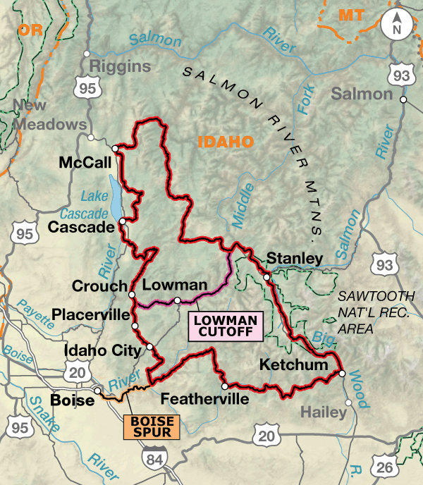
The route is divided into two maps. The Main Route Map contains routing for the main dirt road loop, the paved Lowman Cutoff, which divides the main dirt road loop in half, and the Boise Spur, which guides riders to and from the Boise Airport. The narratives for all routing on the Main Route Map are bi-directional.

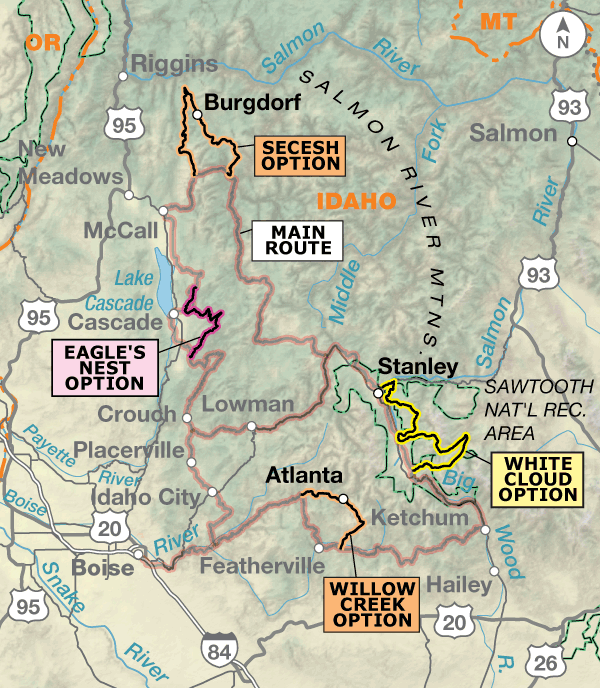
The Singletrack Options Map contains routing for four unique singletrack options. The Singletrack Options Map is a supplement to the Main Route Map, and you will need to purchase both if choosing to incorporate any of the singletrack offerings into your adventure. The four singletrack options are not bi-directional. If you choose to ride them with the main route, you should go in a counter-clockwise direction.

ATTENTION

On August 7, 2015, President Obama signed into law the creation of three new wilderness areas in the Boulder-White Clouds region of Idaho. One of these, the White Clouds Wilderness, encompasses trails we included in the White Clouds Option found on the 2014 version of the Singletrack Options Map of the Idaho Hot Springs Mountain Bike Route (IHSMBR). With the republication and update of the Singletrack Options IHSMBR map in November 2017, a new route avoiding the wilderness has been included. If you have the 2014 map, we advise purchasing the newer map.


A wide variety of road conditions exists along this route. Surfaces range from pavement, good gravel roads, four-wheel-drive roads, singletrack, and old railroad beds. Opportunities to spot wildlife such as black bears, deer, elk, eagles, osprey, and other birds and animals are in abundance on this route. The area is also rich in history with ghost towns, deserted mines, forgotten homesteads, and even the first ski lift erected in the country. The route features 50 hot springs. Amenities range from developed resort-style springs to remote natural pools. The route passes near several designated wilderness areas, including the Selway-Bitterroot and Frank Church-River of No Return, which form the largest wilderness complex in the lower 48 states. No bikes are permitted in any designated wilderness area.

Temperatures tend to be chilly at night and warm-to-hot during the days as you are in mountainous regions most of the way. Snow, hail, and afternoon thunderstorms can be a factor. Medical help is often a long distance off of the route, so riding within your abilities and being aware of dangers is a must. Mosquitoes are a fact of life during certain times of the year — bring repellent.

Photo by Casey Greene

The part of central Idaho that the route traverses is defined by big mountains that form the Idaho Batholith and the rivers that run through it. While names such as the Main Salmon, South Fork of the Salmon, and North Fork of the Payette conjure up images of major rapids and serious rafting, rivers such as the South Fork of the Boise and the Big Wood are some of the West’s most storied fly-fishing waters. The route passes all of these while sometimes climbing high into the mountains from which their headwaters are formed.

Because of this terrain, you will be either gaining elevation, or descending, for the entire route. The elevations are lower near Boise and Crouch — building up to the highest passes near Ketchum and Stanley.

Idaho Hot Springs Mountain Bike Route - Main Route
Section Distance Elevation Total Climb Avg. Climb/mile
Total 763.4 miles Minimum: 3,030 ft.
Maximum:9,590 ft.
42,520 ft. counterclockwise
42,575 ft. clockwise
56 ft. per mi. counterclockwise
56 ft. per mi. clockwise
1 517.5 miles Minimum: 3,030 ft.
Maximum:8,750 ft.
42,520 ft. counterclockwise
42,575 ft. clockwise
82 ft. per mi. counterclockwise
82 ft. per mi. clockwise
2 245.9 miles Minimum: 3,980 ft.
Maximum:9,590 ft.
37,610 ft. counterclockwise
0 ft. clockwise
153 ft. per mi. counterclockwise
0 ft. per mi. clockwise
Idaho Hot Springs Mountain Bike Route Alternates
Name Section Distance Total Climb Avg. Climb/mile
Boise Spur MAIN ROUTE 32.7 miles 2,320 ft. east bound
1945 ft. west bound
71 ft. per mi. east bound
59 ft. per mi. west bound
Lowman Cutoff MAIN ROUTE 58.3 miles 2,710 ft. east bound
6,225 ft. west bound
46 ft. per mi. east bound
107 ft. per mi. west bound

Planning

In the Northern Rockies, the best time to plan for a mountain bike tour is that sweet spot after the snow has melted up high, but before wildfire season starts. In central Idaho, this would mean sometime between late June and late July. If you’re planning your trip six months in advance, shoot for this window. Concerning the other end of the cycling season in Idaho, plan on being off the route by late October. Keep in mind that heavy snows can start accumulating as early as late September. Regardless of when you strike out or how long you intend to be there, pack along rain gear and cold-weather clothing. Light snow and cold rain are possible any day of the year at some of the elevations encountered, and hypothermia is an ever-present possibility.

If you are accustomed to road-oriented bicycle travel, we recommend planning shorter days due to the nature of this route. It is one that requires greater exertions over shorter distances.

We discourage you from attempting to ride this route solo. In fact, a minimum group size of three is strongly recommended. If a rider is debilitated in the backcountry, you will want to have at least one person to stay with the injured/sick rider, and another to go for help. A growing number of backcountry travelers are carrying cell phones for such emergency situations, but be aware that reception is still very spotty along much of the route.

Some campgrounds will charge a cyclist traveling alone less if they have hiker/biker sites, but often they will charge the price of a regular tent site, and that can easily be $10-$20/night. This route goes through national forests and you are allowed to camp anywhere on national forest land as long as you “pack it in, pack it out.” Many city parks are free to camp in.

You may also wish to sign up with Warmshowers, a reciprocal hospitality site for bicycle travelers, for other overnight options.

Tough on Equipment

The Idaho Hot Springs Mountain Bike Route is extremely hard on equipment. The weight of your gear exponentially multiplies the stress of riding steep, fast, rough downhills. Wheels, tires, and drivetrains (chains, cassettes, bottom brackets, chainrings) take a lot of abuse and may even need replacing along the course of the entire route. Suspension equipment on the bicycle helps to mitigate the abusive nature of the terrain. That said, nylon pivots of some full-suspension bikes wear out extremely fast and are not recommended. Suspension seatposts, good handlebar grips, and front-suspension forks help smooth out the many miles of washboarded and chuckholed roads. On the Main Route, weighting a suspension fork with panniers works well, evens the weighting of the bike, and adds a little extra stress to the fork. Trailers would also work well on the Main Route and lighten the rear triangle of the bike.

Well-made camping gear is essential for the many nights of high-elevation cold, dew, and rain. Sleeping bags should be rated to at least 20 degrees Fahrenheit during the summer, and a sleeping pad or inflatable mattress is recommended to add comfort and warmth. A lot of effort must be taken to keep your possessions dry. Pannier covers, dry bags, and plastic freezer bags all work well to keep the rain and dew off clothing and gear. 

High-quality water treatment is mandatory. Advisably, carry one water-treatment system per person. Be it a water filter, chlorine dioxide drops, iodine tablets, or a UV water-treatment device, surface water should be ingested only after employing one of these proven water-treatment methods.

Singletrack Route Options

The nature of riding backcountry singletrack means dealing with the possibility of rough, steep, technical, and unmanicured trails. Plan on encountering all of these while riding any of the four singletrack sections detailed on the Singletrack Options Map. Riders using the Singletrack Options Map should prepare for hike-a-bikes, downed trees, and river crossings. Most of the hike-a-bikes and problematic water crossings are described in the Singletrack Options Map, but one may come across new and variable conditions at any time. Because of these conditions, we strongly suggest riders DO NOT use single-wheel trailers or low-riding front panniers to carry their gear on singletrack. It is illegal to ride with a two-wheel trailer on most singletrack. Packing your gear away from your wheels and maintaining a slim profile to avoid snags is important. We recommend riders use lightweight, bikepacking-style gear and frame bags. We also suggest riders prepare their bodies accordingly for these extreme physical conditions, and significantly lower their expectations on daily mileage. There are very few food services on the singletrack options. You may have to pack up to four days worth of supplies.

Bears

While there has not been a confirmed sighting of a grizzly in this part of Idaho in over half a century, it would not be improbable to find a straggler from the Teton range roaming the eastern extent of the route, which is part of their historic range. A rider will be much more likely to encounter black bears, wolves, or mountain lions, all of which have healthy populations along the entire route. We recommend that you carry bear repellent, available at outdoor sports shops along the route, and become familiar with its safe and proper use. Always be bear-aware, and follow these rules when camping:

  • Store all food, garbage, and other attractants in a bear-resistant manner, well away from your tent. This can include hanging them in a stuff sack from rope slung over a high, isolated tree branch, or storing them in a bear-proof container provided at some campgrounds.
  • Attractants such as food leftovers, fish entrails, and bacon grease should not be buried or burned in campfires. Leftover food and waste should be placed in a sealed bag or container and packed out with garbage. If leftover food or other attractants must be burned, do so in a contained fire stove or in an appropriate container over a campfire, then pack out the ash.

Route Highlights

Idaho Hot Springs Highlights

  • 40 undeveloped backcountry hot springs
  • 10 developed hot springs
  • South Fork of the Salmon River
  • East Fork of the Salmon River
  • Secesh River
  • Big Wood River
  • South Fork of the Boise River
  • Middle Fork of the Boise River
  • South Fork of the Payette River
  • Middle Fork of the Payette River
  • North Fork of the Payette River
  • Salmon River, also known as the River of No Return
  • Sawtooth Range
  • Lick Creek Range, which some locals refer to as the “McCall Alps”
  • Ketchum
  • McCall
  • Cascade
  • Idaho City

More Route Resources


RIDING CONDITIONS

Many wild, remote stretches exist along the route that are not elaborated on here. High temperatures, lofty elevations, wild animals, wildfires, inclement weather (including lightning storms, snow storms, and extremely strong winds), and other potential hazards are plentiful. Un­der­stand how to prepare for and cope with them.

Piped water sources are limited, stock up when you can. High-quality water treatment is strongly recommended. There is plenty of surface water along the route, but it should be ingested only after running it through a good water filter, or using a chemical treatment.

Pack along bug repellent, sunscreen, and a first-aid kit. Carry bicycle tools, a tire pump, and spare tubes. Be prepared for any possibility. You should also carry bear repellent spray, available at outdoor gear shops in the larger towns along the route, and become familiar with its safe and proper use. Always be bear-aware, and follow these rules when camping:

– Store all food, garbage, and other attractants in a bear-resistant manner, well away from your tent. This can include hanging them in a stuff sack from rope slung over a high, isolated tree branch, or storing them in a bear-proof container provided at campgrounds.

– Attractants such as food leftovers, fish entrails, and bacon grease should not be buried or burned in campfires. Leftover food and waste should be placed in a sealed bag or container and packed out with garbage. If leftover food or other attractants must be burned, do so in a contained fire stove or in an appropriate container over a campfire, then pack out the ash.

We discourage you from attempting to ride this route solo; in fact, a minimum group size of three is strongly recommended. If a rider is debilitated in the backcountry, you will want to have at least one person to stay with the injured/sick rider, and another to go for help. A growing number of backcountry travelers are carrying cell phones for such emergency situations – but be aware that reception is very spotty along much of the route.

In the Northern Rockies, the best time to plan for a mountain bike tour is that sweet spot after the snow has melted up high, but before wildfire season starts. This would mean sometime between late June and late July. If you’re planning your trip six months in advance, shoot for this window. Concerning the other end of the cycling season in Idaho, plan on being off the route by late October. Snow can start flying as early as late September.

While signs are sometimes referred to in the narratives, don’t count on them actually being present when you arrive at the designated spot. Signage disappears or changes more frequently than we might like, particularly on this route. Please alert us when you encounter missing signs so we can make the appropriate updates.

This route uses segments of the 900-mile Idaho Centennial Trail (ICT). The main ICT passes through designated wilderness areas, which do not allow bicycling. The pieces we use are alternates that avoid them. The ICT is shown off route as a reference. More information can be found at: advcy.link/ictrl.

Early season riding on this route can be enticing. However be aware that in heavy snow years this may not be viable until well into summer months. Snowpack data can be found online for the following locations: Deadwood Summit advcy.link/deadsno, Banner Summit advcy.link/bannsno, and Galena Summit advcy.link/galsno. For more locations see the National Water and Climate Center’s interactive map at: advcy.link/nwccmap. Snowmelt and rains impact the trails with high water flows and difficult creek crossings. Downed trees are also common and may block the trails creating a stretch of hike-a-bike conditions. While most hike-a-bike sections are contained within the Singletrack Options Map, conditions can change and they may develop on the Main Route over time.

Be aware that wildfire can also close segments of the route. Each year is unique and we advise checking current wildfire status with the National Interagency Fire Center by phoning 208-387-5050 or visiting their website at: advcy.link/fireinfo.

In July 2018, Idaho passed a new trespassing law. Be sure to obey all signs on the ground and make yourself familiar with the law: advcy.link/IDtrespass.

TRAIL GUIDE

We recommend contacting Ranger Offices to check current conditions which will change seasonally.

On the Boise Spur and Idaho City – Featherville, the unpaved portion of Middle Fork Rd./FR 268 can be highly washboarded. For getting around Boise, you can view a map of the Boise River Greenbelt at: advcy.link/brgmap.

The conditions on the Old Galena Toll Rd. trail can be very rough and challenging. SR 75 is an option.

CAMPING, PUBLIC CAMPGROUNDS AND CABINS

The route travels mainly on public land, the majority of which is administered by the U.S. Forest Service. There is an abundance of established Forest Service campgrounds to pitch one’s tent on, or just off, the route. Directions are noted for the campgrounds on route. The amenities of these campgrounds range from reservable sites with RV hookups and showers, to first-come-first-serve sites with fire rings and pit toilets. Campgrounds are open seasonally and open/close dates will vary. Contact Ranger Districts to confirm status, especially in the shoulder season. To get more information on individual campgrounds, and to make reservations, when possible, call 877-444-6777 or visit www.recreation.gov.

In addition to established campgrounds, it is legal to camp anywhere on Forest Service land unless it is posted otherwise. Dispersed camping options abound on the route, especially in valley bottoms and near water sources, but options dwindle on the more steep mountainous stretches.

The Forest Service also maintains and rents a number of historic cabins in the area. Some of these are winter only rentals. Reservations are required. To get more information and to reserve a cabin, guard station, or lookout tower, visit www.recreation.gov.

There are also a few privately owned campgrounds scattered around the map.

HOT SPRINGS

Besides cycling through a beautiful part of the country, an enjoyable activity on this route is to partake in the abundance of natural hot springs. This route has 40 hot springs. Some of these are front-country resort style pools, other are difficult to access and even treacherous to reach at different times of the year. Please use extreme caution and sound judgment when traveling to these springs, especially when attempting to ford a body of moving water. Also, remember hot springs are fragile natural resources and should be treated as such. To help keep them as pristine as possible, we ask you observe any rules posted at the springs and use the following guidelines:

  • Wash before entering a spring. This can include a creek bath or using alcohol based wet wipes.
  • Do not use soap in hot springs. This includes biodegradable varieties.
  • Be considerate of other users. If there are others using a pool, ask how long they are soaking, or if you may join.
  • Stay hydrated. Bike riding and hot springs can leave you severely dehydrated. Have drinking water at your disposal while soaking. If you start to feel light headed, exit the spring and rehydrate. Never drink hot spring water.
  • Always check the temperature of the water before entering the spring.
  • Keep your head out of the water. There are many forms of bacteria around hot springs and some may make you ill if ingested.
  • Do not use glass containers around hot springs.
  • Refrain from sexual activity in or around hot spring.
  • Do not relieve your bladder or bowels anywhere near a hot spring.
  • Pack-it-in, pack-it-out. Please leave all hot springs nicer then you found them, so we all may enjoy them for a long time to come.

RULES

We ask that all riders follow the International Mountain Biking Association’s Rules of the Trail. More info can be found on IMBA’s website: www.imba.com

  • 1. Ride On Open Trails Only. Respect trail and road closures (ask if uncertain); avoid trespassing on private land; obtain permits or other authorization as may be required. Federal and state Wilderness areas are closed to cycling. The way you ride will influence trail management decisions and policies.
  • 2. Leave No Trace. Be sensitive to the dirt beneath you. Recognize different types of soils and trail construction; practice low-impact cycling. This also means staying on existing trails and not creating new ones. Don’t cut switchbacks. Be sure to pack out at least as much as you pack in.
  • 3. Control Your Bicycle. Obey all bicycle speed regulations and recommendations.
  • 4. Always Yield Trail. Let your fellow trail users know you’re coming. A friendly greeting or bell is considerate and works well. Show your respect when passing by slowing to a walking pace or even stopping. Anticipate other trail users around corners or in blind spots.
  • 5. Never Scare Animals. All animals are startled by an unannounced approach, a sudden movement, or a loud noise. This can be dangerous for you, others, and the animals. Give animals extra room and time to adjust to you. When passing horses use special care and follow directions from the horseback rider (ask if uncertain). Leave gates as you found them, or as marked.
  • 6. Plan Ahead. Know your equipment, your ability, and the area in which you are riding – and prepare accordingly.

Updated: May 13, 2021


RIDING CONDITIONS

Many wild, remote stretches exist along the route that are not elaborated on here. High temperatures, lofty elevations, wild animals, wildfires, inclement weather (including lightning storms, snow storms, and extremely strong winds), and other potential hazards are plentiful. Understand how to prepare for and cope with them.

Piped water sources are limited, stock up when you can. High-quality water treatment is strongly recommended. There is plenty of surface water along the route, but it should be ingested only after running it through a good water filter, or using a chemical treatment.

Pack along bug repellent, sunscreen, and a first-aid kit. Carry bicycle tools, a tire pump, and spare tubes. Be prepared for any possibility. You should also carry bear repellent spray, available at outdoor gear shops in the larger towns along the route, and become familiar with its safe and proper use. Always be bear-aware, and follow these rules when camping:

– Store all food, garbage, and other attractants in a bear-resistant manner, well away from your tent. This can include hanging them in a stuff sack from rope slung over a high, isolated tree branch, or storing them in a bear-proof container provided at some campgrounds.

– Attractants such as food leftovers, fish entrails, and bacon grease should not be buried or burned in campfires. Leftover food and waste should be placed in a sealed bag or container and packed out with garbage. If leftover food or other attractants must be burned, do so in a contained fire stove or in an appropriate container over a campfire, then pack out the ash.

We discourage you from attempting to ride this route solo; in fact, a minimum group size of three is strongly recommended. If a rider is debilitated in the backcountry, you will want to have at least one person to stay with the injured/sick rider, and another to go for help. A growing number of backcountry travelers are carrying cell phones for such emergency situations – but be aware that reception is very spotty along much of the route.

In the Northern Rockies, the best time to plan for a mountain bike tour is that sweet spot after the snow has melted up high, but before wildfire season starts. This would mean sometime between late June and late July. If you’re planning your trip six months in advance, shoot for this window. Concerning the other end of the cycling season in Idaho, plan on being off the route by late October. Snow can start flying as early as late September.

While signs are sometimes referred to in the narratives, don’t count on them actually being present when you arrive at the designated spot. Signage disappears or changes more frequently than we might like, particularly on this route. Please alert us when you encounter missing signs so we can make the appropriate updates.

This route uses segments of the 900-mile Idaho Centennial Trail (ICT). The main ICT passes through designated wilderness areas, which do not allow bicycling. The pieces we use are alternates that avoid them. The ICT is shown off route as a reference. More information can be found at: advcy.link/ictrl.

Early season riding on this route can be enticing. However be aware that in heavy snow years this may not be viable until well into summer months. Snowpack data can be found online for the following locations: Secesh Summit advcy.link/secsno, Atlanta (James Creek) Summit advcy.link/atlsno, and Big Creek Summit advcy.link/bigcrsno. For more locations see National Water and Climate Center’s interactive map at: advcy.link/nwccmap. Snowmelt and rains impact the trails with high water flows and difficult creek crossings. Downed trees are also common and may block the trails creating a stretch of hike-a-bike conditions.

Be aware that wildfire can also close segments of the route. Each year is unique and we advise checking current wildfire status with the National Interagency Fire Center by phoning 208-387-5050 or visiting their website at: advcy.link/fireinfo.

In July 2018, Idaho passed a new trespassing law. Be sure to obey all signs on the ground and make yourself familiar with the law: advcy.link/IDtrespass.

SINGLETRACK

The nature of riding backcountry singletrack means dealing with the possibility of rough, steep, technical, and unmanicured trails. Plan on encountering all of these while riding these singletrack options. Riders should prepare for hike-a-bikes, downed trees, and river crossings. Most of the hike-a-bikes and problematic water crossings are described in the Trail Guide section of each option, but one may come across new and variable conditions at any time. Due to these conditions, when planning your itinerary for a tour on this route, you may want to set yourself up for shorter mileage days.

Because of the conditions listed above, we strongly suggest riders DO NOT use single-wheel trailers or low-riding front panniers to carry their gear. It is illegal to ride with a two-wheel trailer on singletrack.

TRAIL GUIDE

Willow Creek Option

The Willow Creek Option starts along the Middle Fork of the Boise River on FR 268 which can be highly washboarded. It first travels to the backside of the Sawtooth Wilderness where riders will encounter the small historic mining town of Atlanta. Services are limited. It leaves town up a steeply graded dirt road, where the last couple of miles are rocky, sometimes overgrown hike-a-bike, before heading off onto beautiful singletrack through an old forest fire burn. The Decker Creek Trail casually follows the creek before its final steep grade up to the summit. There are a few nice primitive camp spots at various creek crossings along Decker Creek.

The descent off the summit is enjoyable. After a short stretch, riders will turn onto Willow Creek Trail. Following a long descent, which ranges from technical to flowing, the route will bring riders back to the main route via a few miles of dirt road. There are numerous primitive camp spots along Willow Creek, including a few near Willow Creek Hot Springs.

Eagle Nest Option

Unlike the other Singletrack Options featured here, the Eagle Nest Option starts out relatively high. After a very short climb, riders will be able to indulge in one of the best descents in the region. The flowing Eagle Nest Trail will deposit riders at Davis Reservoir, then up past Horsethief Reservoir, up and over a ridge, and up again to the East Mountain ATV Trailhead. The East Mountain ATV Trail features short challenging ascents and descents along its length. There is a seasonal spring just upstream from the bridge crossing at Fool Creek. Good primitive camp spots are limited on this option, but there are a few along Clear Creek.

White Cloud Option

The White Cloud Option starts with a short stretch along Pole Creek Road. It climbs out of Grand Prize Gulch and into the East Fork of the Salmon River drainage. After a long descent riders will encounter a major obstacle in the form of a river fording. While this will not pose a problem after early July, it could force early season riders to find an alternate way around. One option would be to backtrack to Pole Creek Road and approach Germania Creek Trail from the west via FR 197 and Trail 111, which has a few smaller creek fordings. Another option would be to head off route at Turn E, following a lesser used trail on the northwest bank of the river to the bridge at the Bowery Guard Station. This option may not always be viable or safe. Please use caution when attempting to ford the river at anytime during the year.

After the Bowery Guard Station, riders will take the East Fork Road north to connect to the Germania Creek Trail 111. The 9.5-mile Germania Creek Trail begins with a short climb that quickly offers great views into the long drainage. Upon descending to the creek, riders will face at least 5 stream crossings and multiple, mostly short hike-a-bikes along the gradual ascent to Washington Lake Trail 109. As with other parts of the singletrack routes, loose rock and gravel may force riders off bikes on the steep descents. This is also a popular hiking trail so watch for hikers. The Washington Lake Trail winds up into open grassy slopes and sparse ponderosa forest en route to Washington Basin, before heading uphill on a stiff hike-a-bike to the divide above Washington Lake Creek.

Upon reaching the creek, the route closely follows it toward Washington Lake. Then it goes up and over to Fourth of July Lake. Both have ideal primitive camp spots. Immediately after Fourth of July Lake, it is pretty much a smooth 2-mile descent to the busy Fourth of July Creek Trailhead. A fast 10.1-mile descent on Fourth of July Creek Road will bring the rider to paved SR 75, but only for a brief 1.7-mile spell.

Fisher Creek Road returns the route to dirt through a burned area which can be potholed, but is very bikeable until the final stretch where it becomes more steep and rough. The popular Fisher Creek Trail 332 is a beautiful, flowy singletrack, mostly downhill, with great views of the surrounding mountains. It sometimes straddles the side of the mountain so an evenly balanced load is key to maintaining balance. Warm Springs Creek Trail 671 is mellow with a few water crossings, mostly flowy ups and downs with a few short climbs and descents and rocky sections. The trail through The Meadows can become overgrown and hard to navigate. There are numerous nice primitive camping opportunities at the creek crossings in this area, especially at the junction with Martin Creek.

Having made it this far, the last major climb will not be as tough as the ones already completed. It still features a few short, steep, loose sections that may call for some hike-a-bike. Riders will find places to refill water in the Garland Lakes area.

After the final pass, the hard work is done. Except for the hump up the ridge above Little Casino Creek, get ready for a seemingly unending rippin’ descent. Use caution, and don’t forget to stop and take in the amazing views of the Sawtooth Range.

Secesh Option

The Secesh Option starts out with a mellow climb up the Zena Creek drainage. After turning off the road, and a short ridable stretch on the Zena Creek Trail, the singletrack turns skyward and riders may have to hike-a-bike. The route continues to a series of short, sometimes steep, climbs and descents along a high ridge. If riders strain their eyes eastward, they will be able to see the Frank Church River of No Return Wilderness. The descent to the Secesh River is steep and loose in spots. Use caution. There are numerous primitive camping spots just across the river from Secesh Hot Springs.

The ride along the Secesh River, up to Loon Lake, and on to Burgdorf Hot Springs is enjoyable. Part of this section has been honored as an IMBA Epic Ride.

After Burgdorf Hot Springs, riders will continue toward the Bear Pete Trail with views of the Salmon River Canyon to the north. The Bear Pete Trail is another spectacular backcountry ridge trail with amazing views. It features numerous steep ascents and descents. Camping spots are limited on this stretch, but there are many small creeks, which flow year-round, to refill a water bottle.

The route descends to the Twentymile Trailhead. The trail itself is graded nicely, but features a few stretches of deep motorbike ruts that may force riders off their bikes. The trail is situated in an old forest fire burn area and you may encounter a number of downed trees. Duck Lake offers beautiful primitive camp spots along its banks.

The first 20 and last 10 miles of this option can be rutted, and be seasonally clogged with downed trees requiring long stretches of hike-a-bike.

CAMPING, PUBLIC CAMPGROUNDS AND CABINS

The route travels mainly on public land, the majority of which is administered by the U.S. Forest Service. There is an abundance of established Forest Service campgrounds to pitch one’s tent on, or just off, the route. Directions are noted for the campgrounds on route. The amenities of these campgrounds range from reservable sites with RV hookups and showers, to first-come-first-serve sites with fire rings and pit toilets. Campgrounds are open seasonally and open/close dates will vary. Contact Ranger Districts to confirm status, especially in the shoulder season. To get more information on individual campgrounds, and to make reservations, when possible, call 877-444-6777 or visit www.recreation.gov.

In addition to established campgrounds, it is legal to camp anywhere on Forest Service land unless it is posted otherwise. Dispersed camping options abound on the route, especially in valley bottoms and near water sources, but options dwindle on the more steep mountainous stretches.

The Forest Service also maintains and rents a number of historic cabins in the area. Some of these are winter only rentals. Reservations are required. To get more information and to reserve a cabin, guard station, or lookout tower, visit www.recreation.gov.

HOT SPRINGS

Besides cycling through a beautiful part of the country, an enjoyable activity on this route is to partake in the abundance of natural hot springs. This route contains 10 hot springs. While one of them – Burgdorf Hot Springs – features front-country resort style pools, it is the exception. The remainder of them can be difficult to access and some even treacherous to reach at different times of the year. Please use extreme caution and sound judgment when traveling to these springs, especially when attempting to ford a body of moving water. Also, remember that hot springs are fragile natural resources and should be treated as such. To help keep them as pristine as possible, we ask that you observe any rules posted at the springs and use the following guidelines:

  • Wash before entering a spring. This can include a creek bath or using alcohol based wet wipes.
  • Do not use soap in hot springs. This includes biodegradable varieties.
  • Be considerate of other users. If there are others using a pool, ask how long they are soaking, or if you may join.
  • Stay hydrated. Bike riding and hot springs can leave you severely dehydrated. Have drinking water at your disposal while soaking. If you start to feel light headed, exit the spring and rehydrate. Never drink hot spring water.
  • Always check the temperature of the water before entering the spring.
  • Keep your head out of the water. There are many forms of bacteria around hot springs and some may make you ill if ingested.
  • Do not use glass containers around hot springs.
  • Refrain from sexual activity in or around hot spring.
  • Do not relieve your bladder or bowels anywhere near a hot spring.
  • Pack-it-in, pack-it-out. Please leave all hot springs nicer then you found them, so we all may enjoy them for a long time to come.

RULES

We ask that all riders follow the International Mountain Biking Association’s Rules of the Trail. More info can be found on IMBA’s website: www.imba.com

  • 1. Ride On Open Trails Only. Respect trail and road closures (ask if uncertain); avoid trespassing on private land; obtain permits or other authorization as may be required. Federal and state Wilderness areas are closed to cycling. The way you ride will influence trail management decisions and policies.
  • 2. Leave No Trace. Be sensitive to the dirt beneath you. Recognize different types of soils and trail construction; practice low-impact cycling. This also means staying on existing trails and not creating new ones. Don’t cut switchbacks. Be sure to pack out at least as much as you pack in.
  • 3. Control Your Bicycle. Obey all bicycle speed regulations and recommendations.
  • 4. Always Yield Trail. Let your fellow trail users know you’re coming. A friendly greeting or bell is considerate and works well. Show your respect when passing by slowing to a walking pace or even stopping. Anticipate other trail users around corners or in blind spots.
  • 5. Never Scare Animals. All animals are startled by an unannounced approach, a sudden movement, or a loud noise. This can be dangerous for you, others, and the animals. Give animals extra room and time to adjust to you. When passing horses use special care and follow directions from the horseback rider (ask if uncertain). Leave gates as you found them, or as marked.
  • 6. Plan Ahead. Know your equipment, your ability, and the area in which you are riding – and prepare accordingly.

Updated: May 13, 2021

Updates to Recently Released Maps

If you are planning a bike tour, be sure to get the most recent map updates and corrections for your route by selecting the route, and the appropriate section(s), from the drop-down menu below.

Over time maps become less useful because things change. Every year Adventure Cycling’s Routes and Mapping Department create map updates and corrections for every map in the Adventure Cycling Route Network, which now totals 52,047 miles. With the help of touring cyclists like you, we receive updates on routing, services, camping, and contact information. Until we can reprint the map with the new information, we verify the suggested changes and publish corrections and updates here on our website.

PLEASE NOTE: Covid has been particularly hard on the small businesses along our routes. While we do our best to keep the maps and these online updates current, you may encounter more closed businesses and longer stretches with limited or no services.

Refer to these updates for the most current information we have and submit reports of changes to the Route Feedback Form for the cyclists coming after you.

NOTE: Map updates and corrections only pertain to long term changes and updates. For short term road closures, please see the Adventure Cycling’s Routes Temporary Road Closures discussion in our Forums.