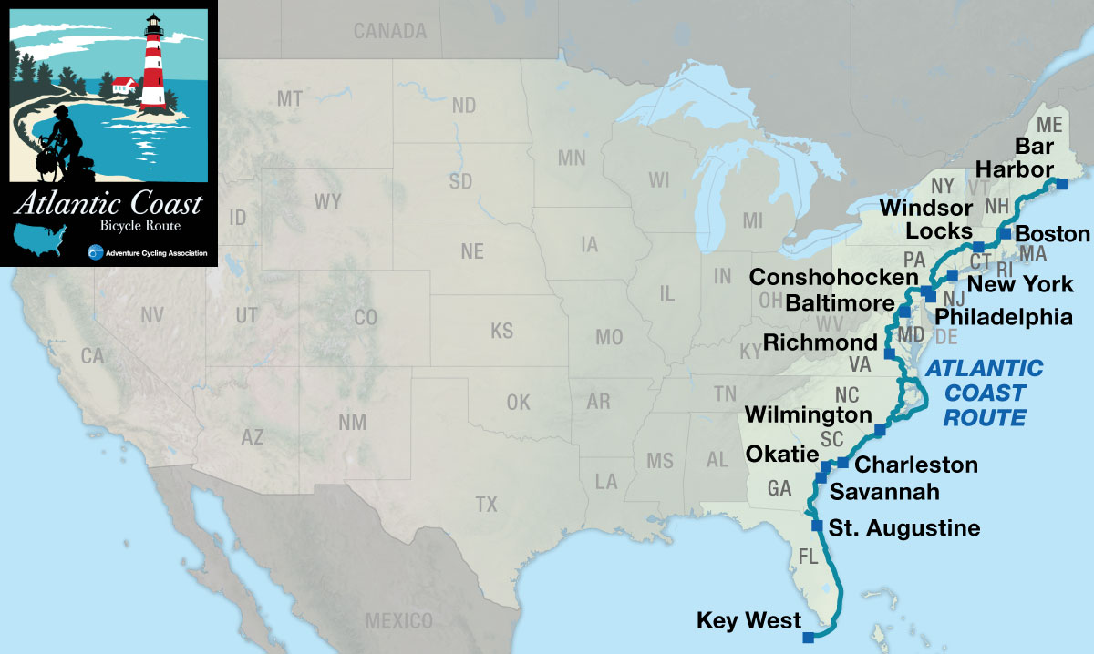
Atlantic Coast
History heaven
The northern sections of the Atlantic Coast Bicycle Route are excellent for history buffs, as you’ll discover sites dating back to the early days of the United States and beyond.

In the Northeast, you’ll enjoy the flavor of quiet Maine coastal towns, New England villages, the rural countryside, and bucolic Amish farmlands. Once you cross the Mason-Dixon Line, which is the boundary between Pennsylvania and Maryland, you’ll ride into the South and get some exposure to Civil War history by visiting the battlefields at Fredericksburg, Virginia, and the city of Richmond, Virginia. Spurs lead into the various larger cities along this route. A lack of road signs can make parts of this route challenging.
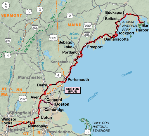
Starting in the tourist town of Bar Harbor, Maine, on Mt. Desert Island, you’ll bike out of town through Acadia National Park and then along occasional back roads situated near the coast. Allow some time to savor the quintessential ambiance of the coastal towns. After crossing the Penobscot River, the route passes by Ft. Knox, an exceptionally well-preserved unused Revolutionary War fort. Most of the route in Maine straddles views of the Atlantic Ocean, from the rocky jagged shore downeast (which is directionally “northeast”) to the expansive sand beaches south of Portland.
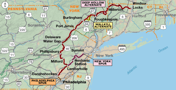
More New England beauty will be enjoyed as you head south through New Hampshire, Massachusetts, Rhode Island, and Connecticut. In Massachusetts you can take a 30.6-mile spur into Boston. You’ll see charming, picturesque towns that you might find on your wall calendar. As you bike through New York, you’ll pass through scenic farmland. Several sites of historic significance are off route north of Poughkeepsie, New York. The route uses portions of several rail trails.
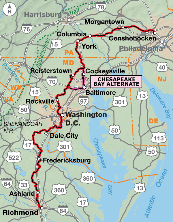
Entering New Jersey, you’ll ride through one of the best areas in the state for bicycling as you travel along the Delaware River. The Delaware Water Gap National Recreation Area is particularly beautiful and gives an other-world meaning to typical images that people have of New Jersey. At Lambertville, the New York City Spur extends eastward for 52 miles to Summit, New Jersey, where you can take a train into New York City. The main route heads west into Pennsylvania through productive farms and many hills. Downtown Philadelphia is a short distance from the route via the Schuylkill River Bike Path. You’ll ride through Valley Forge National Historic Park. The route traverses Lancaster County, which is home to many Amish families. Beginning in York, it follows the York County Heritage Trail which becomes Torrey C. Brown Trail in northern Maryland. The route swings west around the outskirts of Baltimore, though you can take the alternate through the city if you prefer. There are more farms in northern Maryland, which will turn into suburban sprawl as you reach the Washington, D.C., metropolitan area.
Traffic and road congestion increases tremendously north of Washington, D.C. The route uses the Rock Creek Trail and the Capital Crescent Trail to take you to the Lincoln Memorial and the Potomac River. After crossing the Potomac, you’ll ride another beautiful bike path to Mount Vernon, George Washington’s residence from 1754 until his death. Then there are more urban areas in expanding northern Virginia, some quiet country roads, and increasing urbanization as you approach Richmond.
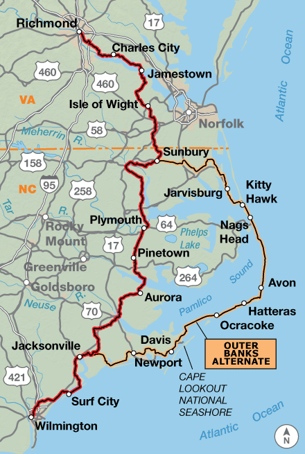
The route uses the Virginia Capital Trail from Richmond to Jamestown. After crossing the James River on a ferry, you’ll head south through the farmlands of Virginia and encounter swamps when crossing into North Carolina. If you choose to ride the Outer Banks Alternate, you’ll have a treat biking along the sandy beaches of the Atlantic Ocean and have the chance to see tools utilized by the famous Wright Brothers in their bicycle shop. Expect high temperatures and humid conditions in the summer, though beach riding will be tempered by ocean breezes. The winds can be strong (that’s why the Wright Brothers flew their first plane there), and sand may blow onto the road. In the Outer Banks, there are two ferry rides, one of which is 2-1/4 hours long.
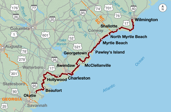
Riding southward, you’ll encounter the busy city of Wilmington, North Carolina, and take another ferry ride into Southport. The route skirts the coast through Myrtle Beach, South Carolina, and surrounding communities. Many tourists visit this area. You’ll also ride through historic Charleston, once described as “an 18th-century painting come to life.”
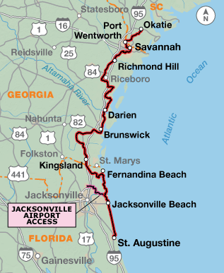
Heading into Georgia, Alligator Alley/SR 170, a scenic road through the Savannah National Wildlife Refuge, offers plenty of opportunities to pull over and gawk at the view. Savannah is a charming city, which has one of the largest national historic landmark districts in the United States. Because the route is close to the coast expect more tourist traffic.
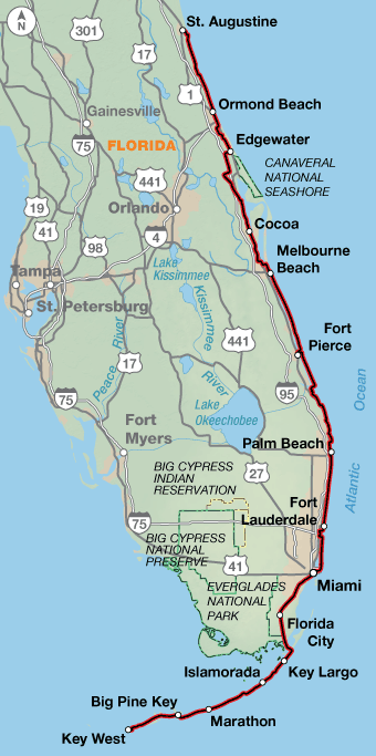
As you cross into Florida, you’ll be alongside the coast again. A spur to reach the Jacksonville Airport for transportation is shown, while the main route continues through occasional coastal towns along the beaches. St. Augustine is the oldest European settlement in the United States, which displays distinctive Spanish architecture. Starting in St. Augustine, the route alternates between urban and suburban conditions most of the way down the coast through Miami. Florida has an extensive though sometimes confusing network of bicycling facilities ranging from 2-foot bike lanes or shoulders to separated bike paths and sidewalks. For some stretches it will be better to use the sidewalk rather than the road while in highly trafficked beach areas, the sidewalks will be pedestrian use only. The approach to often nearly invisible short bridges are usually marked with “frogs”, “buttons”, “turtles”, “slugs” or rumble strips.
Take advantage of the opportunities to enjoy the numerous beach accesses. County parks often include such amenities as picnic tables, cold water, showers and toilets and are inexpensive or free to cyclists. State Highway A1A will change names many times on its journey along the coast. This is especially true as it nears Miami. Often it is located adjacent to an aquatic preserve or wildlife refuge offering bird watching as well. South of Jupiter, campgrounds for tenting are almost nonexistent until south of Miami.
Leaving Florida City on U.S. 1, you begin a 20-mile ride with no services, potentially heavy traffic and abundant crocodile sightings. If you see what appears to be a green couch along the road, it’s probably not! Always give crocs a wide berth, and be ready to sprint if necessary. Crocodiles can reach speeds of 30 miles per hour for very short distances. On the road to Key West the roadways have generous shoulders, though we recommend using the bike paths. Give yourself plenty of time to enjoy this section and have your camera at the ready. As you cross the many old bridges there are multiple occasions to stop and take in the scenery. Each of the Keys offers their own information center with local knowledge of available activities. If you wish to stay at one of the Bahia Honda State Park campsites, make reservations early. For those who don’t wish to reverse their route back across the Keys, a loop route can be created by taking a ferry from Key West to Fort Myers Beach where it is possible to join the Florida Connector and return to West Palm Beach. Space is limited on the ferries, so when you make your reservations, be sure to let them know in advance that you have a bike.
Photo by Tom Robertson
The Atlantic Coast Bicycle Route is one of the more challenging routes that Adventure Cycling has to offer, as it has many hilly areas where granny gears are needed to negotiate the steep climbs. Northwestern Connecticut, the Susquehanna River area in Pennsylvania, and the country roads north of Richmond are extremely hilly. But you do have some easy riding to compensate, such as when biking the paths along the Potomac River in Virginia. While there is some hill climbing upon leaving Richmond, Virginia, generally the terrain is either rolling or flat through the southern states of North and South Carolina, Georgia and Florida.
| Atlantic Coast - Main Route | ||||
|---|---|---|---|---|
| Section | Distance | Elevation | Total Climb | Avg. Climb/mile |
| Total | 2649.0 miles | Minimum: 0 ft.Maximum:1440 ft. | 72,890 ft. south bound72,355 ft. north bound | 28 ft. per mi. south bound27 ft. per mi. north bound |
| 1 | 473.2 miles | Minimum: 0 ft.Maximum:1130 ft. | 25,825 ft. south bound25,375 ft. north bound | 55 ft. per mi. south bound54 ft. per mi. north bound |
| 2 | 302.4 miles | Minimum: 0 ft.Maximum:1440 ft. | 15,950 ft. south bound16,055 ft. north bound | 53 ft. per mi. north bound53 ft. per mi. south bound |
| 3 | 368.9 miles | Minimum: 0 ft.Maximum:860 ft. | 17,295 ft. south bound17,165 ft. north bound | 47 ft. per mi. south bound47 ft. per mi. north bound |
| 4 | 379.1 miles | Minimum: 0 ft.Maximum:160 ft. | 5,380 ft. south bound5,430 ft. north bound | 14 ft. per mi. south bound14 ft. per mi. north bound |
| 5 | 357.0 miles | Minimum: 0 ft.Maximum:60 ft. | 3,400 ft. south bound3,335 ft. north bound | 10 ft. per mi. south bound9 ft. per mi. north bound |
| 6 | 262.1 miles | Minimum: 0 ft.Maximum:45 ft. | 2,105 ft. south bound2,065 ft. north bound | 8 ft. per mi. north bound8 ft. per mi. north bound |
| 7 | 506.3 miles | Minimum: 0 ft.Maximum:40 ft. | 2,935 ft. south bound2,930 ft. north bound | 6 ft. per mi. south bound6 ft. per mi. north bound |
| Atlantic Coast Alternates | ||||
|---|---|---|---|---|
| Name | Section | Distance | Total Climb | Avg. Climb/mi |
| Boston Spur | 1 | 30.6 miles | 1,110 ft. east bound1,520 ft. west bound | 36 ft. per mi. east bound50 ft. per mi. west bound |
| New York Spur | 2 | 46.9 miles | 2,790 ft. east bound2,505 ft. west bound | 59 ft. per mi. east bound53 ft. per mi. west bound |
| Philadelphia Spur | 2 | 10.6 miles | 150 ft. south bound170 ft. north bound | 14 ft. per mi. south bound16 ft. per mi. north bound |
| Deep Hollow Alternate | 2 | 6 miles | 700 ft. south bound200 ft. north bound | 117 ft. per mi. south bound33 ft. per mi. north bound |
| Wallkill Alternate | 2 | 19.1 miles | 865 ft. south bound200 ft. north bound | 45 ft. per mi. south bound10 ft. per mi. north bound |
| Chesapeake Bay Alternate | 3 | 47.4 miles | 2,910 ft. south bound2,700 ft. north bound | 61 ft. per mi. south bound57 ft. per mi. north bound |
| Outer Banks Alternate | 4 | 254.5 miles | 1,630 ft. south bound1,640 ft. north bound | 6 ft. per mi. south bound6 ft. per mi. north bound |
| Jacksonville Airport Access | 6 | 21.2 miles | 140 ft. east bound160 ft. west bound | 7 ft. per mi. east bound8 ft. per mi. west bound |
This route can be ridden from late spring to mid-fall in the north (typically May to October), and all year around in the south. Expect high temperatures and humid conditions during the summer. Due to changing local conditions, it is difficult to predict any major wind patterns. Be aware that hurricanes can occur from June through November along the Atlantic Seaboard and can close roads and services along the Outer Banks Alternate on Section 4.
Services are generally plentiful along the route. Some spur routes, such as the ones into Boston, New York City, and Philadelphia, can take you into large cities for whatever you may desire. People who like to camp won’t find any campgrounds in Maryland unless they do the Chesapeake Bay Alternate through Baltimore. Some cyclists may want to do the northern portions of this route during the colors of autumn. If you do, call ahead to verify campground availability because many close after Labor Day. If staying indoors, make advance reservations.
If camping on the Outer Banks, it can sometimes be blustery at night. Check locally for any upcoming storms. Because the route stays closer to the coast in South Carolina and Georgia, services for tourists are plentiful. In Florida, services can be scarce in the suburban/residential areas of cities. Almost everything else you encounter, including food, will be more expensive due to the tourist nature of the beach communities. Reservations for camping and hotel accommodations are highly recommended year-round.
Some campgrounds will charge a cyclist traveling alone less if they have hiker/biker sites, but often they will charge the price of a regular tent site, and that can easily be $10-$40/night. The maps list churches that have opened their doors to cyclists, but they aren’t all that closely spaced. If you’re friendly and ask around, you can often get yourself invited to camp in a yard. Our routes sometimes go through national forests (moreso in the west) and you are allowed to camp anywhere on national forest land as long as you “pack it in, pack it out.” Many city parks are free to camp in.
You may also wish to sign up with Warmshowers, a reciprocal hospitality site for bicycle travelers, for other overnight options.
Route Highlights
Atlantic Coast Highlights
- Acadia National Park, Section 1
- Fort Knox State Park, Section 1
- L.L. Bean, Section 1
- Portland Headlight, Section 1
- Boston Spur, Section 1
- Eleanor and F.D. Roosevelt National Historic Sites, Section 2
- Delaware Water National Recreation Area, Section 2
- New York City Spur, Section 2
- Philadelphia Spur, Section 2
- Valley Forge National Historic Park, Section 3
- Baltimore, Maryland, Chesapeake Bay Alternate, Section 3
- Washington, D.C., Section 3
- Mt. Vernon, home of President George Washington, Section 3
- Fredericksburg Spotsylvania National Military Park, Section 3
- Richmond National Battlefield Park, Section 4
- Williamsburg, Virginia, Section 4
- Colonial National Historical Park, Section 4
- Kitty Hawk, North Carolina, Outer Banks Alternate, Section 4
- Cape Hatteras National Seashore Recreation Area, Outer Banks Alternate, Section 4
- USS N.C. Battleship Memorial, Section 5
- Charleston, South Carolina, Section 5
- Savannah Wildlife Refuge, South Carolina/Georgia, Section 6
- Savannah, Georgia, Section 6
- Fort King George Historic Site, Georgia, Section 6
- Amelia Island State Park, Florida, Section 6
- Big and Little Talbot Islands State Parks, Florida, Section 6
- Guana Tolomato Matanzas Research Reserve, Florida, Section 6
- St. Augustine, Florida, Section 6
- Kennedy Space Center, Section 7
- Miami, Florida, Section 7
- Key West, Florida, Section 7
Updates to Recently Released Maps
If you are planning a bike tour, be sure to get the most recent map updates and corrections for your route by selecting the route, and the appropriate section(s), from the drop-down menu below.
Over time maps become less useful because things change. Every year Adventure Cycling’s Routes and Mapping Department create map updates and corrections for every map in the Adventure Cycling Route Network, which now totals 52,047 miles. With the help of touring cyclists like you, we receive updates on routing, services, camping, and contact information. Until we can reprint the map with the new information, we verify the suggested changes and publish corrections and updates here on our website.
PLEASE NOTE: Covid has been particularly hard on the small businesses along our routes. While we do our best to keep the maps and these online updates current, you may encounter more closed businesses and longer stretches with limited or no services.
Refer to these updates for the most current information we have and submit reports of changes to the Route Feedback Form for the cyclists coming after you.
NOTE: Map updates and corrections only pertain to long term changes and updates. For short term road closures, please see the Adventure Cycling’s Routes Temporary Road Closures discussion in our Forums.