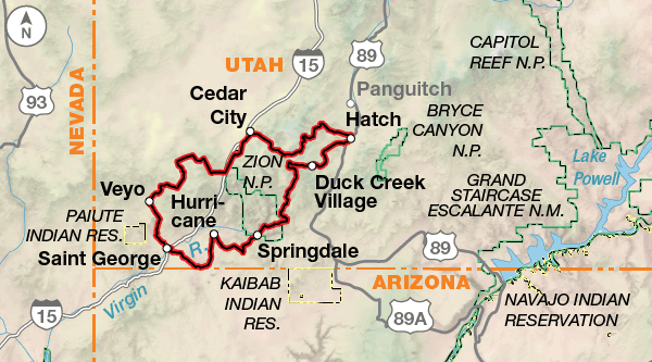
Utah Cliffs Loop

Due to limited resources, the paper map version of this route has been discontinued. This route is still available digitally.
Explore “Color Country.”
Southwestern Utah is known by many as “Color Country.” You’ll discover how apt this nickname is as you encounter the rich hues of the red rock cliffs and pedal through the cool greens of the sub-alpine forests that the route visits.
Cliffs are an inescapable part of your view on the Utah Cliffs Loop. You’ll catch your first glimpse of the Hurricane Cliffs in the distance as you pedal northward out of St. George on a bike path winding through Snow Canyon State Park. This beautiful park encompasses white and red sandstone cliffs with an overlay of black lava rock. The route then heads for historic Pine Valley, nestled in a bucolic basin in the Pine Valley Mountains. As you continue your journey in a clockwise direction, the Hurricane Cliffs loom to the east until just outside of Cedar City, where you’ll begin to climb up and through the Hurricane Cliffs escarpment, high onto the Markagunt Plateau of the Dixie National Forest. Later, as you descend through the timber at the beginning of North Fork Road, be sure to take in the view of the Pink Cliffs to the east.
Use caution as you approach Zion National Park on Zion-Mt. Carmel Highway. Traffic will increase and the White Cliffs will tower over the road on your left. Just south of Zion National Park, you might consider a side trip to the nearby ghost town of Grafton, a filming site for the 1969 blockbuster, Butch Cassidy and the Sundance Kid.
Next up: Smithsonian Butte and Gooseberry Mesa, which lead into the Vermilion Cliffs that begin here and flirt with the Utah-Arizona border to the south. The approach to Hurricane runs along the edge of the Hurricane Cliffs on a rough four-wheel-drive road.
Due to the high elevations of this route, be prepared to deal with extreme temperature differences between morning and mid-day and night. Also, the summer months can bring frequent afternoon thunderstorms. Fall weather is ever-changing and it is not uncommon to have snow flurries at 10,000′ elevation as early as late August. However, these conditions typically pass within hours at that time of year. Wind can occasionally be a problem as weather fronts enter the state. In the summer and fall, most storms come from the south and southwest, and can kick up incredible amounts of dust.
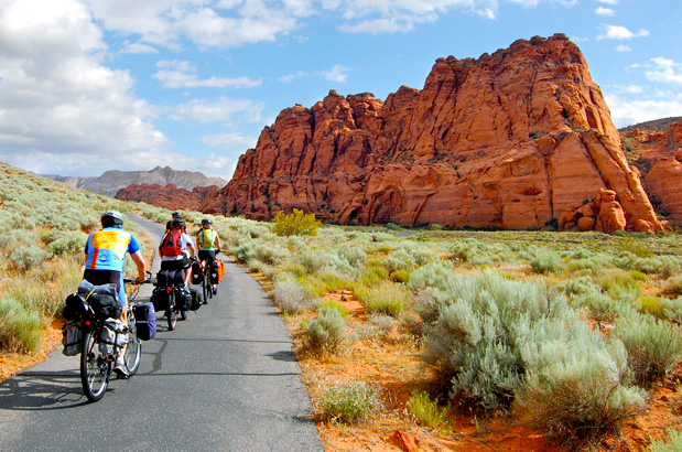
Photo by Doug Goodenough
From St. George, heading clockwise, the route climbs northward to Snow Canyon State Park. From Cedar City prepare for a tough climb up through the Hurricane Cliffs escarpment, high onto the Markagunt Plateau of the Dixie National Forest. At Navajo Lake, still at high elevation, you begin an unforgettable downhill run that starts out alongside the North Fork of the Virgin River – really just a creek at first – and ultimately meets SR 9 just east of Zion National Park. The route out of Rockville toward Smithsonian Butte is extremely steep and potentially slick and muddy when wet. After Hurricane you’ll then enjoy a slightly downhill ride most of the way back to St. George. Elevations on the route range from 2,500′ to 10,000′ above sea level.
| Utah Cliffs Loop - Main Route | ||||
|---|---|---|---|---|
| Section | Distance | Elevation | Total Climb | Avg. Climb/mile |
| Total | 286.2 miles | Minimum: 2,560 ft.Maximum:9915 ft. | 24,150 ft. clockwise ft. clockwise | 84 ft. per mi. clockwise ft. per mi. clockwise |
RIDING CONDITIONS
The 286.2-mile Utah Cliffs Loop Bicycle Route circles through a staggering array of landscapes, ranging from brilliant redrock desert to high subalpine forests of pine and fir. From St. George, heading clockwise, the route goes north to Snow Canyon State Park and then heads for historic Pine Valley, nestled in a bucolic basin in the Pine Valley Mountains. From Cedar City you climb through the Hurricane Cliffs escarpment, high onto the Markagunt Plateau of the Dixie National Forest. At Navajo Lake, still at high elevation, you begin an unforgettable downhill run that starts out alongside the North Fork of the Virgin River – really just a creek at first – and ultimately meets SR 9 just east of Zion National Park. From Rockville, a series of backroads lead to Hurricane and, finally, back to St. George. Elevations on the route range from 2,500’ to 10,000’ above sea level.
Prepare for a tough climb between Cedar City and FR 240. Gravel FR 240, can get quite muddy, boggy, and rutted after a rain. The first part of the dirt road between Duck Creek Village and Navajo Lake also has a tendency to get muddy when wet. Both stretches of route on SR 14 (19.8 miles near Cedar City and 4.3 miles around Duck Creek Village) can be highly trafficked in the summer months. It tends to be narrow in most places with a variable shoulder width. Ride with caution.
During the summer months, Zion-Mt. Carmel Highway/SR 9 through Zion National Park to Rockville carries high traffic volumes. In Zion National Park there are two tunnels on the Zion-Mt. Carmel Highway. Bicycles are prohibited in the longer Zion-Mt. Carmel tunnel. Cyclists must hitch a ride in a pick-up truck. The descent from the tunnels is steep and winding. For further access into the Park, cyclists can ride the Pa’rus Trail and Zion Canyon Scenic Dr. This road is closed to private vehicles but shuttle buses run frequently on it. Near and in any national park cyclists will have to contend with higher traffic levels and RV drivers who are inexperienced. To avoid heavy traffic try to ride early in the day and make yourself and your bike visible.
The route south of Rockville toward Smithsonian Butte is extremely steep and potentially nasty when wet. Southeast of Hurricane, you’ll be riding on a rugged, steep four-wheel-drive road that drops into Hurricane 1.5 miles later. SR 59 through Apple Valley has high traffic levels and no shoulder. If you do not want to ride the 4.4 miles on it you can use SR 9 and SR 17 as an alternate. Traffic levels are lower and the shoulders are wider.
Throughout the route, any gravel and/or dirt road has the potential to become washboarded due to usage and weather factors. Be aware that many Forest Service campgrounds on the route are only open from Memorial Day to Labor Day. Also many do not have water.
U.S. Bicycle Route (USBR) 70 and has been designated in Utah. Portions of our route run concurrent with it. For more information and maps see advcy.link/utusbr.
CLIMATE
Utah’s four-season climate with low humidity and abundant sunshine is conducive to many outdoor activities, including cycling. The deserts bloom in late spring as melting snows fill the rivers. Daytime summer temperatures range from 72° to 105° F while overnight temperatures can be as much as 40° F cooler. Timing your ride can be challenging. When it’s not too hot for comfort in St. George, there’s a good chance it’ll be too cold and/or snowy in the upper elevations. The best months for riding the route are typically September and October, when the high country is still free of snow and the temperatures have cooled from the summer highs at lower elevations.
Updated: Feb 16, 2021
Route Highlights
Utah Cliffs Loop Highlights
- Snow Canyon State Park
- Cedar Break National Monument
- Virgin River Rim Trail
- Zion National Park
More Route Resources
- U.S. Bicycle Route System
- U.S. Bicycle Route 70 (Utah)
- Utah Road Conditions
- Utah DOT Seasonal Highway Closures
- Zion National Park Bicycle Policy
- Dixie National Forest
- Connect and share photos with other riders on Instagram: #acaUtahCliffs
Updates to Recently Released Maps
If you are planning a bike tour, be sure to get the most recent map updates and corrections for your route by selecting the route, and the appropriate section(s), from the drop-down menu below.
Over time maps become less useful because things change. Every year Adventure Cycling’s Routes and Mapping Department create map updates and corrections for every map in the Adventure Cycling Route Network, which now totals 52,047 miles. With the help of touring cyclists like you, we receive updates on routing, services, camping, and contact information. Until we can reprint the map with the new information, we verify the suggested changes and publish corrections and updates here on our website.
PLEASE NOTE: Covid has been particularly hard on the small businesses along our routes. While we do our best to keep the maps and these online updates current, you may encounter more closed businesses and longer stretches with limited or no services.
Refer to these updates for the most current information we have and submit reports of changes to the Route Feedback Form for the cyclists coming after you.
NOTE: Map updates and corrections only pertain to long term changes and updates. For short term road closures, please see the Adventure Cycling’s Routes Temporary Road Closures discussion in our Forums.