Washington Parks
Double loop route packed with parks, mountains, ocean views.
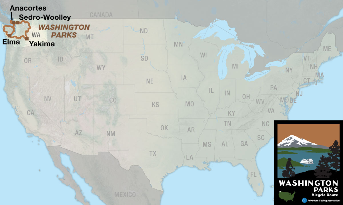
This double loop, two map section route showcases the diversity of the state of Washington, from its ocean and sound views in the west to the fertile orchards of the central Columbia Valley while traversing three national parks. The beginning and end points are technically Sedro-Woolley and Elma, though the abundance of ferries in and around Seattle allow great flexibility in planning.
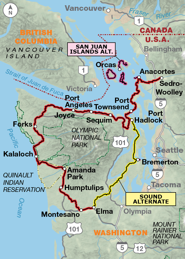
Section one of the Washington Parks Bicycle Route begins by heading west (counter-clockwise) out of Sedro-Woolley where the route provides the first opportunity to board a ferry. From Anacortes, the San Juan Islands (Lopez, Orcas and San Juan) are easily accessed via a frequent ferry schedule. The islands are a “must see” for many bicycle tourists, each bearing its own flavor with mostly low-trafficked roads and hilly riding. Back on the main route, the next stop is Port Townsend, a historic seaport with a host of tourist activities from galleries and shopping to dining and quaint bed and breakfasts. Continuing along the coast the route follows the Olympic Discovery Trail from Sequim to Port Angeles, the gateway to Olympic National Park, which is the first of three national parks on this route. Be sure to leave yourself time to visit the park’s visitor center in town and stretch your legs on one of the many day hike options.
From Port Angeles to Elma it is mostly rural riding with recreational traffic and occasional logging trucks. South of Forks is one of the most scenic areas of the route, with incredible views and ample opportunities to explore the shorelines from the beach parking lots. Once in Elma, you have two options, to head north and finish the loop in Port Townsend via the 110.4-mile Sound Alternate or continue east on section two toward Mt. Rainier National Park for the larger loop across central Washington.
The Sound Alternate is a mostly rural connection back to Port Townsend that includes a spur to Bremerton, with an option for a ferry to downtown Seattle. The Kitsap Peninsula has an active naval base just north of Silverdale. Off route several miles east is the town of Poulsbo. They proudly celebrate their rich Norwegian heritage from the vibrant waterfront park to the shopping district with a wide array of delicious baked goods.
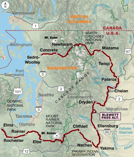
Section two of the Washington Parks Bicycle Route begins in Elma and heads east (counter-clockwise) into the foothills of the Cascades. Eatonville has its roots in the lumber industry. In spite of the closure of the mill in 1942, it continues to grow as a residential community and recreational jumping off spot for the region. Traffic volume increases as you approach Mt. Rainier National Park, especially June through August. As you leave the park, you will crest two mountain passes in rapid succession, Cayuse Pass and Chinook Pass. The grade of these ascents is roughly a steady 5-8%. From here it is mostly downhill to the cities of Yakima and Selah, situated on the Yakima River.
The environment on the eastern side of the Cascades is markedly drier as you follow the Yakima River north to Ellensburg. Continuing north, you’ll traverse Old Blewett Pass (4,071′) before reaching U.S. 2/97. The route then follows the Columbia River where you’ll pass many orchards. At Pateros, you’ll head northeast, then will begin climbing the eastern slope of the Cascade Mountains. The North Cascades National Park and the Ross Lake National Recreation Area provides multiple opportunities to get off the bike and try a day hike. The route continues on State Route 20 until Marblemount, where local roads are used to avoid heavy traffic. They generally follow the Skagit River to Sedro-Woolley where the loop began.
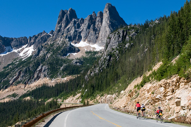
Photo by Gregg Bleakney
Leaving Sedro-Woolley headed west the route is rolling down to Sequim where it flattens out along the Straight of Juan De Fuca. Heading south from the coast the route will start to roll again with smaller hills. From Elma, the Sound Alternate heading back north begins with a small climb, and then is rolling again back to where it rejoins the main route south of Port Townsend. From Elma headed east on section two, the route gradually starts to climb, culminating in two mountain passes in Mt. Rainier National Park. The route then descends mostly to the Yakima area, before starting to climb along the Yakima River, culminating with Old Blewett Pass south of Cashmere. After a slow descent, the road starts to slowly climb as it follows the Columbia and Methow rivers, topping out at the 5,477′ Washington Pass west of Mazama, before slowly descending along the Skagit River to Sedro-Woolly.
| Washington Parks - Main Route | ||||
|---|---|---|---|---|
| Section | Distance | Elevation | Total Climb | Avg. Climb/mile |
| Total | 866.4 miles | Minimum: 0 ft.Maximum:5,460 ft. | 46,345 ft. counterclockwise46,640 ft. clockwise | 53 ft. per mi. counterclockwise54 ft. per mi. clockwise |
| 1 | 313.9 miles | Minimum: 0 ft.Maximum:800 ft. | 15,590 ft. counterclockwise15,615 ft. clockwise | 50 ft. per mi. counterclockwise50 ft. per mi. clockwise |
| 2 | 552.5 miles | Minimum: 20 ft.Maximum:5,460 ft. | 30,755 ft. counterclockwise31,025 ft. clockwise | 56 ft. per mi. counterclockwise56 ft. per mi. clockwise |
| Washington Parks Alternates | ||||
|---|---|---|---|---|
| Name | Section | Distance | Total Climb | Avg. Climb/mi |
| San Juan Islands Loop | 1 | 25.8 miles | 2,040 ft. clockwise2,025 ft. counterclockwise | 79 ft. per mi. clockwise78 ft. per mi. counterclockwise |
| Sound Alternate | 1 | 110.4 miles | 5,925 ft. north bound5,875 ft. south bound | 54 ft. per mi. north bound53 ft. per mi. south bound |
| San Juan Islands Option | 1 | 3.5 miles | 155 ft. west bound180 ft. east bound | 44 ft. per mi. west bound51 ft. per mi. east bound |
| Lopez Island Loop | 1 | 31.0 miles | 2,070 ft. clockwise2,055 ft. counterclockwise | 67 ft. per mi. clockwise66 ft. per mi. counterclockwise |
| Orcas Island Out and Back Option (one way) | 1 | 21.4 miles | 3,805 ft. north bound1,415 ft. south bound | 178 ft. per mi. north bound66 ft. per mi. south bound |
| Seattle Ferry Spur | 1 | 1.5 miles | 150 ft. east bound180 ft. west bound | 100 ft. per mi. east bound120 ft. per mi. west bound |
| Blewett Pass Alternate | 2 | 13.2 miles | 1,105 ft. counterclockwise1,615 ft. clockwise | 84 ft. per mi. counterclockwise122 ft. per mi. clockwise |
This route is best ridden late spring to mid-fall (typically May to October). Due to heavy snow falls, the highway in North Cascades National Park is usually closed mid-November to mid-April though the park remains open with limited access. For an opening date call the Park at (360) 856-5700.
From Port Angeles to Elma, with the exceptions of Forks, Amanda Park and Montesano, services are sparse so be prepared with food and water. Some longer days will also be required if you desire to stay in hotels along this section. Be sure to plan ahead around Mt. Rainier National Park during the summer tourist season. The crowds pick up and reservations are recommended for campgrounds and motels. As a full service town, Ellensburg is a good spot to replenish your supplies and perhaps pick up a spare tube at the bike shop.
Some campgrounds will charge a cyclist traveling alone less if they have hiker/biker sites, but often they will charge the price of a regular tent or RV site, and that can easily be $10-$30/night. If you’re friendly and ask around, you can often get yourself invited to camp in a yard. Our routes sometimes go through national forests (moreso in the west) and you are allowed to camp anywhere on national forest land as long as you “pack it in, pack it out.” Many city parks are free to camp in.
You may also wish to sign up with Warmshowers, a reciprocal hospitality site for bicycle travelers, for other overnight options.
Route Highlights
Washington Parks Highlights
- San Juan Islands, Section 1
- Olympic National Park, Section 1
- Mt. Rainier National Park, Section 2
- Ross Lake National Recreation Area, Section 2
- North Cascades National Park, Section 2
More Route Resources
- How to Ride the Washington Parks Route [VIDEO]
- U.S. Bicycle Route System
- How to Travel with your Bike on Amtrak
- No-Turn-Away Bike Camping Policies
- U.S. Bicycle Route 10
- U.S. Bicycle Route 97
- Washington State Ferry System
- Olympic Discovery Trail
- Yelm-Tenino Trail
- Yakima Greenway Trail
- North Cascades Highway (State Route 20) status
- Cascade Trail
- Connect and share photos with other riders on Instagram: #acaWashParks
Updates to Recently Released Maps
If you are planning a bike tour, be sure to get the most recent map updates and corrections for your route by selecting the route, and the appropriate section(s), from the drop-down menu below.
Over time maps become less useful because things change. Every year Adventure Cycling’s Routes and Mapping Department create map updates and corrections for every map in the Adventure Cycling Route Network, which now totals 52,047 miles. With the help of touring cyclists like you, we receive updates on routing, services, camping, and contact information. Until we can reprint the map with the new information, we verify the suggested changes and publish corrections and updates here on our website.
PLEASE NOTE: Covid has been particularly hard on the small businesses along our routes. While we do our best to keep the maps and these online updates current, you may encounter more closed businesses and longer stretches with limited or no services.
Refer to these updates for the most current information we have and submit reports of changes to the Route Feedback Form for the cyclists coming after you.
NOTE: Map updates and corrections only pertain to long term changes and updates. For short term road closures, please see the Adventure Cycling’s Routes Temporary Road Closures discussion in our Forums.