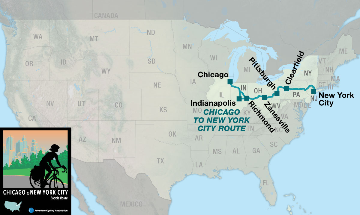
Chicago to New York City (CNYC)
Route Options
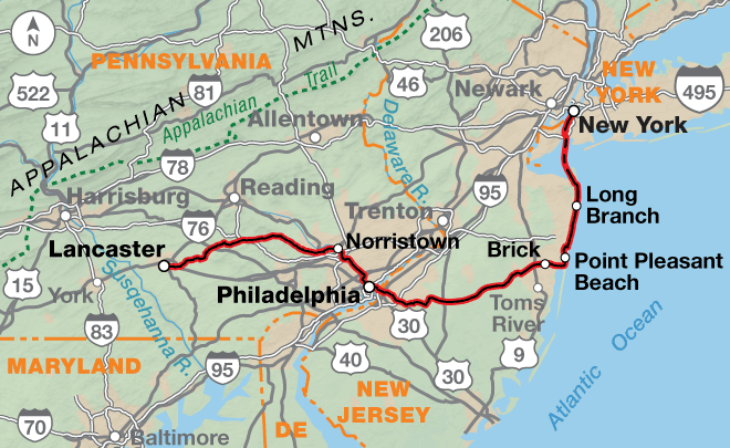
The Chicago to New York City Bicycle Route includes a main route and the Philadelphia Alternate, which stretches from Pittsburgh, Pennsylvania to New York City. This page describes the 1,160.3-mile main route from Chicago, Illinois to New York City, New York. If you choose to combine the main route with the Philadelphia Alternate the mileage is 1,172.9 miles. On section 3, in Pittsburgh, is the intersection where you’ll switch maps from following the main route to the Philadelphia Alternate.
To make an informed decision about whether to choose the main route or the Philadelphia Alternate, here is a list of the major differences.
- Main route: more hills and short steep hills in eastern Pennsylvania and New York with more paved roads.
- Philadelphia Alternate: 150 miles on the GAP, mostly unpaved on a crushed limestone surface, and 85 miles on the C&O Trail, mostly unpaved on a dirt surface which can be slick and hard to ride in wet conditions. The maximum grade is 1.5%. There are multiple tunnels. Eastern Pennsylvania is rolling while New Jersey becomes flatter the closer the route gets to the Atlantic Ocean.
The Windy City to the Big Apple
Cities, small towns, farmland, forests, roads, and trails — this route has it all! The Chicago to New York City Bicycle Route includes a main route and the Philadelphia Alternate, which goes between Pittsburgh, Pennsylvania and New York City. Heading east from Chicago you’ll go through Indianapolis, Columbus, and Pittsburgh. In Pittsburgh you can choose to follow the main route, which crosses Pennsylvania into New Jersey. It then enters New York City from the north. If you choose the Philadelphia Alternate you’ll ride the Great Allegheny Passage and a portion of the C&O Canal Trail in Maryland. After leaving Philadelphia, the route goes east to the New Jersey shore and ends with a ferry ride into New York City from the south.
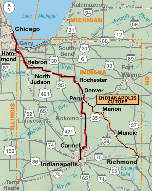
When combined with Bicycle Route 66, this route completes a cross-country link from Los Angeles, California all the way to New York City. It begins in downtown Chicago along Lake Michigan. You’ll be riding trails and city streets to make your way through Chicago and its suburbs, which extend into Indiana. The riding through Indiana is on flat to rolling terrain that originally supported the tallgrass prairie ecosystem. Indiana is characterized by small towns and mid-sized cities with ample services. The route follows several bike paths as it heads southward, including the North Judson Erie Trail, the Nickel Plate Trail, and the Monon Trail into downtown Indianapolis. The city has mostly one-way streets, but well signed bike lanes and paths are the norm.
The 103.7-mile Indianapolis Cutoff between Peru and Richmond saves 50 miles. Except for the first 20 miles of county roads to Converse and about 15 miles on county highways south of Jonesboro, the cutoff uses three rail trails. The Converse Junction Trail, the Sweetser Switch Trail, and the Cardinal Greenway take cyclists through Marion and Muncie and on to Richmond.
Leaving Indianapolis, the route follows designated bike routes into the eastern suburbs and then onto county roads. Central eastern Indiana and central western Ohio are flat with occasional rolling sections until you reach Columbus.
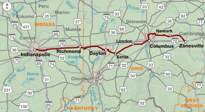
East of Richmond, Indiana, the route follows low-trafficked county roads to Brookville, Ohio and then joins the Wolf Creek Recreation Trail to Trotwood. On the west side of Dayton, you’ll ride rural residential roads and bike paths to the Great Miami River Trail through the downtown area. The Mad River Bikeway, the Creekside Trail, and the Ohio to Erie Trail provide almost continuous car-free riding from Dayton to Columbus. From Xenia to seven miles east of London, this section of route is also on the Underground Railroad Route.
In Columbus, the Camp Chase Trail and the Scioto Trail take you near downtown. The route then turns north following the Olentangy River along the Olentangy Trail, and bike lanes on residential streets. Further north the route passes through the Ohio State University campus and northern Columbus suburbs. East of the capital city you will encounter hillier terrain. The TJ Evans Trail and the Panhandle Trail take you into and out of Newark with a two-mile section on city roads through downtown. A state highway with good shoulders through rolling hills will then take you past the Dillon State Park into Zanesville, a mid-size town.
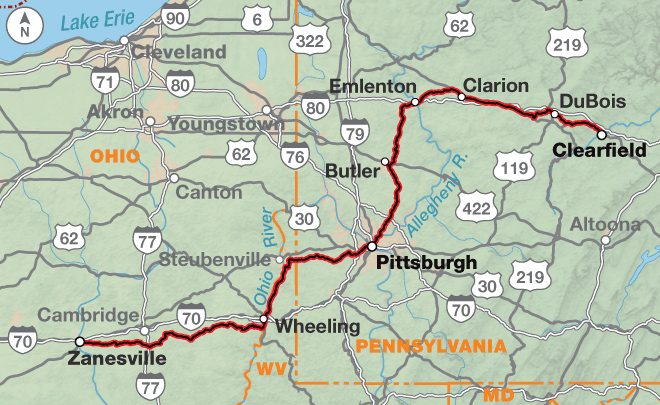
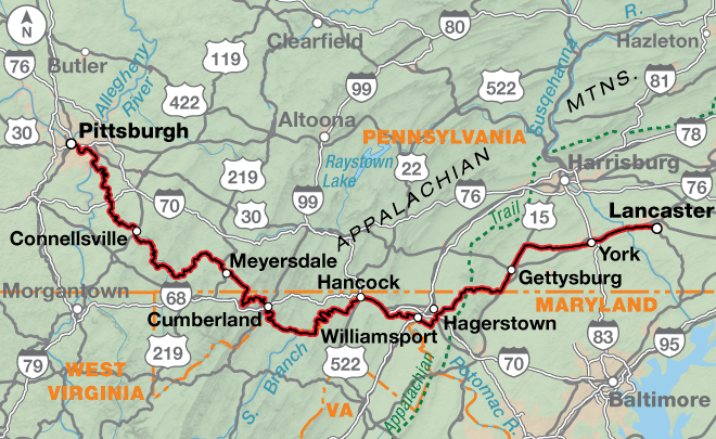
Eastern Ohio, West Virginia, and Pennsylvania get hillier as you enter the Appalachian Plateau region. This section of the route heads northeast and includes county and state highways, numerous bike paths, and occasional busy city streets in Pittsburgh and its suburbs. Oil and gas development has increased in this region, though in Ohio most of the development and truck traffic is north of the route. In eastern Ohio, the route travels rural county roads with no shoulders, and some with no centerlines. The lightly-trafficked state highways also have minimal to no shoulders. Roads can be winding. When crossing into West Virginia on the historic Wheeling Suspension Bridge, walk your bike on the sidewalk to avoid the grated deck. This was the first bridge, built in 1849, to cross the Ohio River. From Wheeling to Wellsburg, you’ll ride along the Ohio River for 17 miles on the Wheeling Heritage Trail, the Brooke Pioneer Trail, and the Wellsburg Yankee Trail. At Follansbee, the route climbs over a steep ridge before descending to the Panhandle Trail. Its surface is crushed limestone. The trail ends 24.6 miles later in Rennerdale, about eight miles southwest of Pittsburgh. A suburban highway with good shoulders carries you down to the Ohio River and then to the Three Rivers Heritage Trail system in Pittsburgh. This network of trails allows you to cross the Monongahela and Allegheny rivers and bypass downtown Pittsburgh traffic. The route between Etna and Emlenton is on rural county roads and state highways with variable shoulders amongst rolling hills. At Emlenton, the route joins signed BicyclePA Route V on state and federal highways. With the exception of the busier urban streets in the towns of Clarion, Brookville, DuBois, and Clearfield, traffic is light.
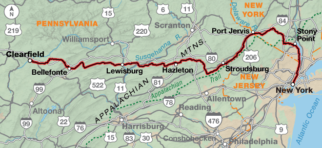
Clearfield is located in north central Pennsylvania on the West Branch of the Susquehanna River. The route continues to follow signed BicyclePA Route V across the state to Delaware Water Gap on the state border with New Jersey. With exceptions through some towns, the route uses light to moderately-trafficked roads, most with minimal shoulders of 12-18 inches wide. East of Clearfield, you will transition from the Appalachian Plateau to the Ridge and Valley Appalachians. This belt forms a broad arc between the Appalachian Plateau and the Blue Ridge Mountains, and is characterized by long, even ridges with long continuous valleys in between. Most of the route follows the valleys, however, a couple ridge crossings provide steeper climbs (up to 10% grades) on narrow winding roads. Between Delaware Water Gap and Port Jervis, New York you’ll parallel the Delaware River through the Delaware Water Gap National Recreation Area. Roads are narrow and quiet, not well signed, and services are scarce. This section of route is also on the Atlantic Coast Bicycle Route. In New York, the route follows secondary state highways and rural roads to Goshen, where you pick up the Orange Heritage Trail to Monroe. Kanawauke Rd. through Harriman State Park is narrow and twisty and sees significant seasonal and weekend traffic. The residential boulevards connecting Harriman State Park to West Haverstraw are narrow and have grades exceeding 12% for approximately two to three miles. South of West Haverstraw, the route follows signed New York State Bicycle Route 9, a popular on-road route for New York City cyclists. It will take you to the George Washington Bridge to cross the Hudson River into Manhattan. A few blocks on city streets will drop you down to the Hudson River Greenway, which is a major bike commuter route into and out of the city. Pedestrian traffic on the bike path will increase significantly. The route ends at Battery Park, located at the southern tip of Manhattan Island. The park includes statues and memorials. Along the waterfront, Statue Cruises offers ferries to the Statue of Liberty and Ellis Island.
Photo by Saara Snow
This route includes a wide variety of terrain from flat to rolling farmland interspersed with swatches of forests. Eastern Ohio, West Virginia, and western Pennsylvania become hillier as you enter the Appalachian Plateau region. East of Clearfield, the land transitions from the Appalachian Plateau to the Ridge and Valley Appalachians. This belt forms a broad arc between the Appalachian Plateau and the Blue Ridge Mountains, and is characterized by long, even ridges with long continuous valleys in between. Most of the route follows the valleys, however, a couple of ridge crossings provide steeper climbs (up to 10% grades) on narrow winding roads. West of the Hudson River in New York, the residential boulevards connecting Harriman State Park to West Haverstraw are narrow and have grades exceeding 12% for short distances.
There are numerous rail trails on this route, and grades on them are typically less than 2%.
| Chicago to New York City Route - Main Route | ||||
|---|---|---|---|---|
| Section | Distance | Elevation | Total Climb | Avg. Climb/mile |
| Total | 1160.3 miles | Minimum: 0 ft.Maximum:2350 ft. | 51,600 ft. east bound52,110 ft. west bound | 44 ft. per mi. east bound45 ft. per mi. west bound |
| 1 | 230.8 miles | Minimum: 690 ft.Maximum:1230 ft. | 3345 ft. east bound3240 ft. west bound | 14 ft. per mi. east bound14 ft. per mi. west bound |
| 2 | 274.6 miles | Minimum: 690 ft.Maximum:1230 ft. | 6170 ft. east bound6115 ft. west bound | 22 ft. per mi. east bound22 ft. per mi. west bound |
| 3 | 295.8 miles | Minimum: 625 ft.Maximum:2350 ft. | 20170 ft. east bound19655 ft. west bound | 68 ft. per mi. east bound66 ft. per mi. west bound |
| 4 | 359.1 miles | Minimum: 0 ft.Maximum:1860 ft. | 21915 ft. east bound23100 ft. west bound | 61 ft. per mi. east bound64 ft. per mi. west bound |
| Chicago to New York City Philadelphia Alternate | ||||
|---|---|---|---|---|
| Section | Distance | Elevation | Total Climb | Avg. Climb/mile |
| Total | 518.5 miles | Minimum: 0 ft.Maximum:2,735 ft. | 15,405 ft. east bound15,720 ft. west bound | 30 ft. per mi. east bound30 ft. per mi. west bound |
| 1 | 338.7 miles | Minimum: 225 ft.Maximum:2,735 ft. | 10,370 ft. east bound10,320 ft. west bound | 31 ft. per mi. east bound30 ft. per mi. west bound |
| 2 | 179.8 miles | Minimum: 0 ft.Maximum:680 ft. | 5,035 ft. east bound5,400 ft. west bound | 28 ft. per mi. east bound30 ft. per mi. west bound |
| Chicago to New York City Route Alternates | ||||
|---|---|---|---|---|
| Name | Section | Distance | Total Climb | Avg. Climb/mile |
| Indianapolis Cutoff | 1 | 103.7 miles | 2,080 ft. east bound1,735 ft. west bound | 20 ft. per mi. east bound17 ft. per mi. west bound |
This route can be ridden from mid-spring to mid-fall (typically April to mid-September). Expect high temperatures and humid conditions during the summer. In Indiana, prevailing winds are from the southwest during most of the year. Watch for tornadoes in the spring. Due to changing local conditions, it is difficult to predict any major wind patterns along the remainder of the route.
Services are generally plentiful, though there will be occasional exceptions. Multiple bike shops are located in the larger metropolitan areas. To camp every night, you will need to plan your overnights carefully and ride off the route. Very few campgrounds are located on route.
Some cyclists may want to ride this route during the colors of autumn. If you do, call ahead to verify campground availability because many close after Labor Day. If staying indoors, make advance reservations.
Some campgrounds will charge a cyclist traveling alone less if they have hiker/biker sites, but often they will charge the price of a regular tent site, and that can easily be $10-$20/night. If you’re friendly and ask around, you can often get yourself invited to camp in a yard. Many small town city parks are free to camp in.
You may also wish to sign up with Warmshowers, a reciprocal hospitality site for bicycle travelers, for other overnight options.
Route Highlights
Chicago to New York City Route Highlights
- Chicago Lakefront, Section 1
- Hoosier Prairie State Nature Preserve, Section 1
- Tippecanoe River State Park, Section 1
- International Circus Hall of Fame and Museum, Section 1
- Indianapolis Cultural Trail, Section 2
- The National Road, Section 2
- Dayton Aviation Heritage National Historical Park, Section 2
- Battelle Darby Creek Metro Park, Section 2
- Appalachian Plateau Region, Section 3
- Wheeling Suspension Bridge, Section 3
- Settlers Cabin Park, Section 3
- Duquesne Incline, Section 3
- Delaware Water Gap National Recreation Area, Section 4
- Hickory Run State Park, Section 4
- Harriman State Park, Section 4
- Palisades Interstate Parkway, Section 4
Updates to Recently Released Maps
If you are planning a bike tour, be sure to get the most recent map updates and corrections for your route by selecting the route, and the appropriate section(s), from the drop-down menu below.
Over time maps become less useful because things change. Every year Adventure Cycling’s Routes and Mapping Department create map updates and corrections for every map in the Adventure Cycling Route Network, which now totals 52,047 miles. With the help of touring cyclists like you, we receive updates on routing, services, camping, and contact information. Until we can reprint the map with the new information, we verify the suggested changes and publish corrections and updates here on our website.
PLEASE NOTE: Covid has been particularly hard on the small businesses along our routes. While we do our best to keep the maps and these online updates current, you may encounter more closed businesses and longer stretches with limited or no services.
Refer to these updates for the most current information we have and submit reports of changes to the Route Feedback Form for the cyclists coming after you.
NOTE: Map updates and corrections only pertain to long term changes and updates. For short term road closures, please see the Adventure Cycling’s Routes Temporary Road Closures discussion in our Forums.