Delmarva
Visit the first state for America, the last state for Adventure Cycling.
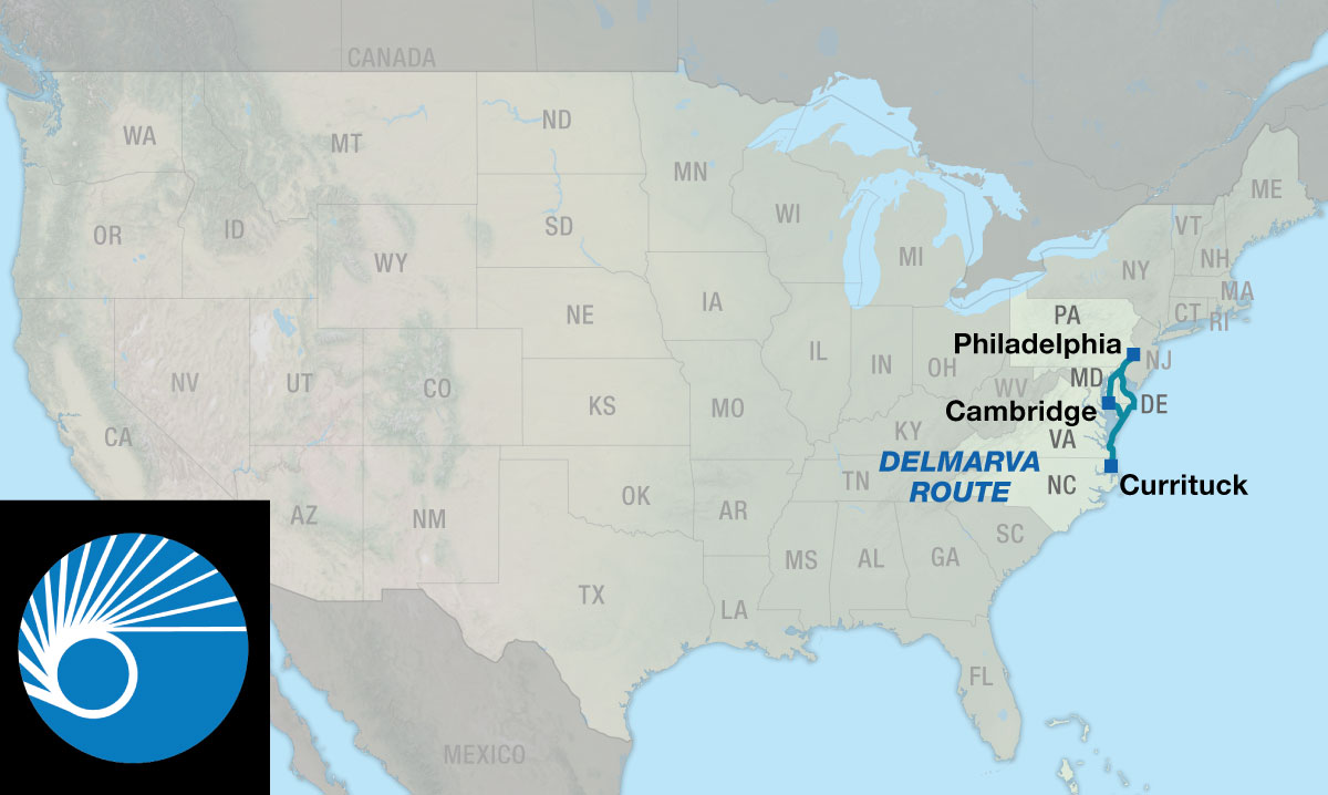
The Delmarva Bicycle Route creates another route option parallel to the Atlantic Coast Route between Philadelphia and the Outer Banks town of Currituck, North Carolina along the historic and scenic Delmarva Peninsula. Just a short distance from one-third of the nation’s population you can explore almost 600 miles of the peninsular region that includes Delaware, the eastern and western shore of Maryland, and a small strip of Virginia separating the Chesapeake Bay from the Atlantic Ocean. The toponym “DelMarVa” is a clipped compound of three state names: Delaware, Maryland, and Virginia. Delaware, as it so happens, not only offers world-class biking but is also the last of the lower 48 states in the U.S. to include a route mapped by Adventure Cycling.
While the main route adheres to early American history hotspots and extensive sand beaches on the eastern coast of Delaware, a separate alternate route option is available that eschews the summer vacation traffic and meanders down the Eastern Shore of Maryland along the Chesapeake Bay. On this side things are a bit quieter, long sand expanses are replaced by green coastal marshes and waterways, and the rich cultural/natural landmarks of Harriet Tubman Underground Railroad National Historical Park and Blackwater National Wildlife Refuge are worth slowing down for.
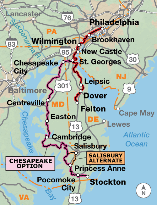
Starting at the art museum in Philadelphia at the intersection of the Atlantic Coast Route and Chicago to New York City Philadelphia Alternate Route, cyclists follow the Schuylkill River Trail to the South Street Bridge and enter the University of Pennsylvania campus, where bikes must be walked on weekdays. Beyond campus, the Baltimore Pike Bike Route helps cyclists maneuver through the epicenter of the Philadelphia-Wilmington metro area. Entering Delaware, the urban riding continues to the terminus of the Jack A. Markell Trail in Wilmington, a separated paved-and-sometimes-boardwalk bike path along rivers and over marshland bridges south to the historic village of New Castle on the banks of the Delaware River.
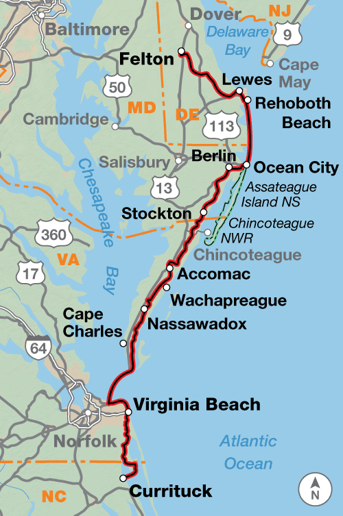
At the small hamlet of St. Georges, reached via the smooth pavement of the Michael Castle Trail paralleling the Chesapeake and Delaware Canal, the 193.5-mi. Chesapeake Option departs the main route under the U.S. 13 bridge. Southward, the main route quickly leaves the U.S. 13 corridor, utilizing secondary state and county roads through a bevy of state and federal wildlife areas to the state capital in Dover. Near the section-end town of Felton, the route joins Delaware Bike Route 1 and closely follows until the Georgetown-Lewes and Junction and Breakwater Trails deliver the rider to the famous beach boardwalks of Rehoboth Beach. Traversing beach barrier islands becomes the name of the game along SR 1 for several miles to the south, across the Maryland border and ultimately all the way to Ocean City. You’ll be sharing this stretch of highway with traffic in summer months, but cycling accommodations in the form of signage, painted shoulders/sharrows, and numerous bike paths should help ease the passage.
Back on the mainland, the route soon brings a rider within striking distance of a pair of quintessential barrier island ecosystems: Assateague Island National Seashore and Chincoteague National Wildlife Refuge. An excursion of several miles off route is required to reach either, but the intrepid traveler will be repaid with an almost 40-mi. long strip of sand beach offering oceanside primitive camping, and most famously, herds of feral ponies descended, as legend would have it, from survivors of wrecked 17th century Spanish galleons off the Virginia coast.
Further south, the water closes in on both sides as the route follows the narrow “tail” of the southern peninsula. Although U.S. 13 provides a thoroughfare striking through the center, cyclists will be heartened to deal with the bends and turns of parallel SR 600 instead of dodging heavy highway traffic. In Capeville, more riding joy is found on the Southern Tip Bike and Hike Trail which provides a separated, multi-use path all the way to the north toll gate for the Chesapeake Bay Bridge-Tunnel near Cape Charles. After a shuttle deposits you at the south toll gate in urban Virginia Beach, the white-knuckling is kept as brief as possible. Residential roads and bike paths circumnavigate the busy part of U.S. 60 along the beach, and then lead directly to First Landing State Park, where English colonists landed in 1607. Navigating the southern outskirts of the city, you’ll soon find yourself on the North Carolina state line negotiating a narrow causeway through the wild and watery Mackay Island Wildlife Refuge to Knotts Island. A short ferry ride will land you at the dock in Currituck, at route’s end. If it suits your fancy, hop on the intersecting Outer Banks Alternate on Atlantic Coast Route Section 4 to continue your beachy sojourn.
CC image courtesy of Michael Stokes on Flickr
Expect marginal terrain changes in the northern reaches along the Pennsylvania/Delaware border, where the route abuts the extreme south edge of the Allegheny Plateau. Southward, the hills are soon ironed out on the main peninsula. Expect little to no elevation change except small localized hills from Lewes to all points south.
| Delmarva - Main Route | ||||
|---|---|---|---|---|
| Section | Distance | Elevatiion | Total Climb | Avg. Climb/mile |
| Total | 350.1 miles | Minimum: 0 ft.Maximum:230 ft. | 5,370 ft. south bound5,305 ft. north bound | 15 ft. per mi. south bound15 ft. per mi. north bound |
| 1 | 107.4 miles | Minimum: 0 ft.Maximum:230 ft. | 2,785 ft. south bound2,725 ft. north bound | 26 ft. per mi. south bound25 ft. per mi. north bound |
| 2 | 242.7 miles | Minimum: 0 ft.Maximum:60 ft. | 2,585 ft. south bound2,580 ft. north bound | 11 ft. per mi. south bound11 ft. per mi. north bound |
| Delmarva Alternates | ||||
|---|---|---|---|---|
| Name | Section | Distance | Total Climb | Avg. Climb/mile |
| Chesapeake Option | 1 | 193.5 miles | 2,920 ft. south bound2,865 ft. north bound | 15 ft. per mi. south bound15 ft. per mi. north bound |
| Salisbury Alternate | 1 | 21.7 miles | 180 ft. north bound205 ft. north bound | 8 ft. per mi. north bound9 ft. per mi. north bound |
This route can generally be ridden from late spring to mid-fall (typically April to October), though parts of it will be snow-free all year. Expect high temperatures and humid conditions during the summer. Due to changing local conditions, it is difficult to predict any major wind patterns. Be aware that hurricanes can occur from June through November along the Atlantic Seaboard and can close roads and services. Heavy summer traffic along SR 1 between Rehoboth Beach, Delaware and Ocean City, Maryland should be expected.
Note: The crossing of the Chesapeake Bay Bridge Tunnel is not possible by bike. Before making the jaunt to the extreme southern tip of the peninsula, book your shuttle reservation. If the shuttle isn’t running, it’s a long ride back north the way you came!
The route begins near downtown Philadelphia, a heavily-urban metropolitan area that experiences lots of traffic and congestion. Early or late on a weekend day should present easier conditions for navigation by bike. The Schuylkill River Trail has many intersecting bike paths requiring your attention. Upon entering the University of Pennsylvania campus, bikes must be walked from Mon.- Fri. 8:30-5:30. Expect the urban riding conditions to continue the entire distance between Philadelphia to Wilmington.
There are multiple boardwalks on the route, like in Wilmington, Delaware and Ocean City, Maryland. Exercise caution on these wooden surfaces especially when wet. Crowds may need to be maneuvered through on these boardwalks, forcing a cyclist to walk their bike. There is a ~ 3 mi. unpaved stretch on the Junction and Breakwater Trail north of Rehoboth Beach, Delaware.
There are several bridges on the Chesapeake Option that cyclists should exercise caution upon when crossing. These bridges include the 0.8-mi. SR 213 bridge near Chesapeake City, and the 0.3-mi. SR 213 bridge near Chestertown. U.S. 50 is a fast, high traffic, divided trunk road, but oftentimes it has very wide shoulders, including over river bridges near Cambridge and Vienna.
There is a general lack of on route camping services on the Chesapeake Option. As a result, we have listed three that are between 6-10 miles off route. Keep this in mind when planning overnight destinations. Otherwise, there are motels/hotels along this alternate route at daily intervals.
On the Chesapeake Option, the ferry at Whitehaven has irregular hours, so be sure to check if it is running before turning south on SR 352 or leaving Princess Anne to the north. If closed, the 21.7-mile Salisbury Alternate offers a route across the Wicomico River and also provides access to services through an area that is rather devoid of them.
There are no bike shops on route between Ocean City, Maryland and Virginia Beach, Virginia, a stretch of nearly 150 miles.
You may also want to sign up with Warmshowers, a reciprocal hospitality site for bicycle travelers, for other overnight options.
Route Highlights
Delmarva Highlights
- Philadelphia Museum of Art and downtown sites, Section 1
- University of Pennsylvania, Section 1
- Baltimore Pike Bike Route, Section 1
- Jack Markell Trail, Wilmington, Section 1
- First State National Historical Park, Section 1
- Lums Pond State Park, Section 1
- Chesapeake and Delaware Canal and Michael Castle Trail, Section 1
- Chesapeake and Delaware Canal Museum, Section 1
- Tuckahoe State Park, Section 1
- Choptank River Lighthouse, Section 1
- Harriet Tubman Underground Railroad National Historical Park, Section 1
- Blackwater National Wildlife Refuge, Section 1
- Harriet Tubman Childhood Home, Section 1
- Bucktown General Store, Section 1
- Bombay Hook National Wildlife Refuge, Section 1
- Killens Pond State Park, Section 2
- Cape Henlopen State Park, Section 2
- Georgetown Lewes and Junction and Breakwater Trails, Section 2
- Delaware Seashore State Park, Section 2
- Ocean City Boardwalk, Section 2
- Assateague Island National Seashore, Section 2
- Chincoteague National Wildlife Refuge, Section 2
- Kiptopeke State Park, Section 2
- Southern Tip Bike and Hike Trail, Section 2
- First Landing State Park, Section 2
- Mackay Island National Wildlife Refuge, Section 2
More Route Resources
- Baltimore Pike Bike Route (Pennsylvania)
- Michael Castle Trail (Delaware)
- Jack A. Markell Trail (Delaware)
- Delaware Bike Route 1
- Georgetown-Lewes Trail (Delaware)
- Junction and Breakwater Trail (Delaware)
- Whitehaven Ferry (Maryland)
- Blackwater National Wildlife Refuge (Maryland)
- Harriet Tubman National Historical Park (Maryland)
- Assateague Island National Seashore (Maryland)
- Chincoteague National Wildlife Refuge (Virginia)
- Chincoteague Ponies (Virginia)
- Southern Tip Bike and Hike Trail (Virginia)
- Chesapeake Bay Bridge-Tunnel Shuttle (Virginia)
- Knotts Island-Currituck Ferry (North Carolina)
- Connect and share photos with other riders on Instagram: #acaDelmarva
Updates to Recently Released Maps
If you are planning a bike tour, be sure to get the most recent map updates and corrections for your route by selecting the route, and the appropriate section(s), from the drop-down menu below.
Over time maps become less useful because things change. Every year Adventure Cycling’s Routes and Mapping Department create map updates and corrections for every map in the Adventure Cycling Route Network, which now totals 52,047 miles. With the help of touring cyclists like you, we receive updates on routing, services, camping, and contact information. Until we can reprint the map with the new information, we verify the suggested changes and publish corrections and updates here on our website.
PLEASE NOTE: Covid has been particularly hard on the small businesses along our routes. While we do our best to keep the maps and these online updates current, you may encounter more closed businesses and longer stretches with limited or no services.
Refer to these updates for the most current information we have and submit reports of changes to the Route Feedback Form for the cyclists coming after you.
NOTE: Map updates and corrections only pertain to long term changes and updates. For short term road closures, please see the Adventure Cycling’s Routes Temporary Road Closures discussion in our Forums.