Arkansas High Country Route

Arkansas High Country Route GPX Data | Overview | Buy | Mobile App
1. SOUTH - Little Rock, AR to Little Rock, AR Detail
2. NORTH - Bentonville, AR to Bentonville, AR Detail

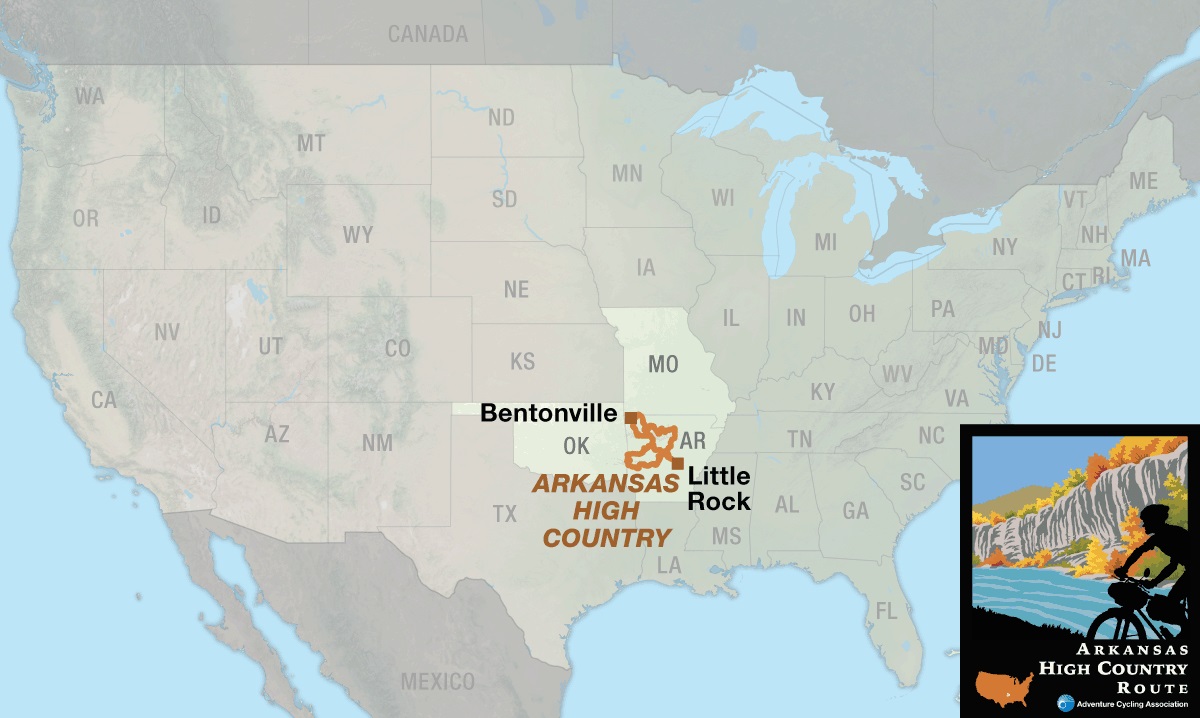
Get Your Wows in the Ouachitas.

Sparkling streams, hills and hollows, shady rivers, mountain views, waterfalls, swimming holes, historic sites, bustling cities – the Arkansas High Country Route has it all. According to local route designer Chuck Campbell, “That route don’t go no where — It just runs around everywhere!” Indeed, this route is designed to connect many of the interesting places in west-central and northwest Arkansas.

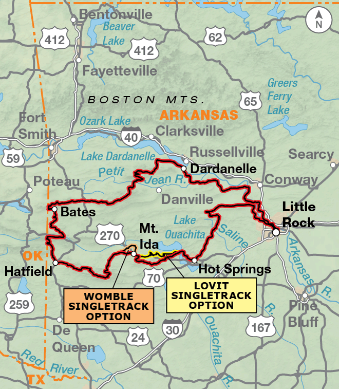
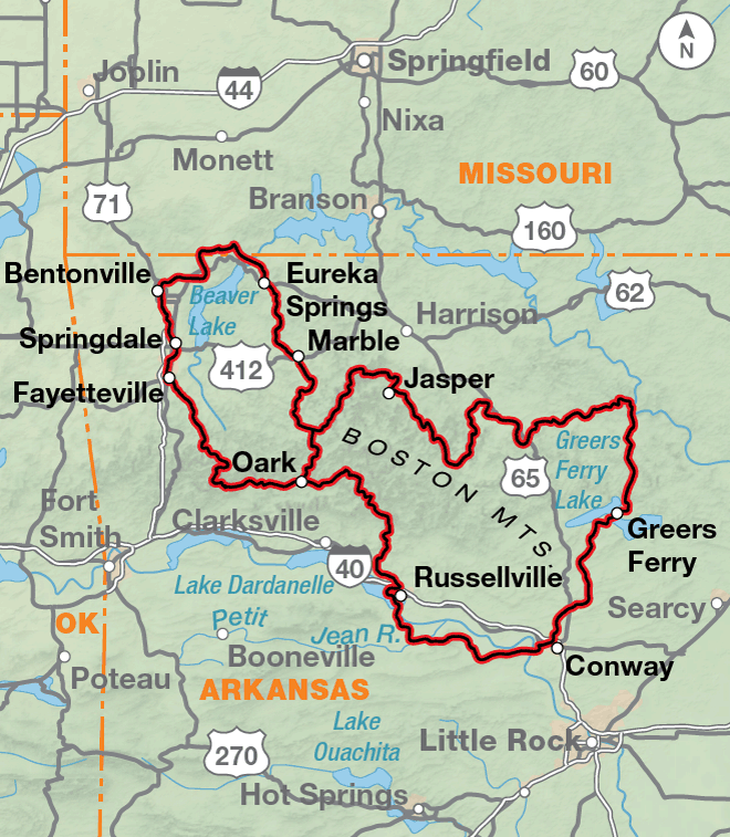
The route is comprised of three large adjacent loops: the South Loop, the Central Loop, and the Northwest Loop. The South Loop, on map section 1, begins and ends in Little Rock. The Northwest and Central Loops, on map section 2, begin and end in Bentonville and Russellville, respectively. A cyclist can choose to ride one or more of the loops, or ride the perimeter of all the loops – it’s up to you.

An additional choice on the South Loop features two singletrack options, using the entire Lake Ouachita Vista Trail (LOViT), and the southern portion of the Womble Trail. Both are International Mountain Bike Association (IMBA) EPIC trails.

Since the routing on the three loops is roughly 50% gravel and 50% pavement, and the climbs/descents can reach gradients between 17 – 21%, choose your bike carefully. Riders who are in a hurry will choose a race geometry gravel bike. Those who choose comfort over speed will elect for full suspension or fat tires to pad the ride. Much of the gravel roads are easily ridden, but there are sections with washboards and cathead boulders. A minimum of 37mm tires with some tread is highly recommended. A wide variety of road conditions exist. National Forest roads can have rough surfaces with loose gravel.

The route passes near multiple designated wilderness areas, including the Flatside, Caney Creek, Upper Kiamichi River, Black Fork Mountain, Poteau Mountain, Dry Creek, Upper Buffalo and Buffalo, and Richland Creek wildernesses. No bikes are permitted in any designated wilderness area.

Arkansas Parks and Recreation Foundation

The Arkansas High Country Route was made possible through the generous support of the Arkansas Parks and Recreation Foundation, with additional support from Adventure Cycling members.

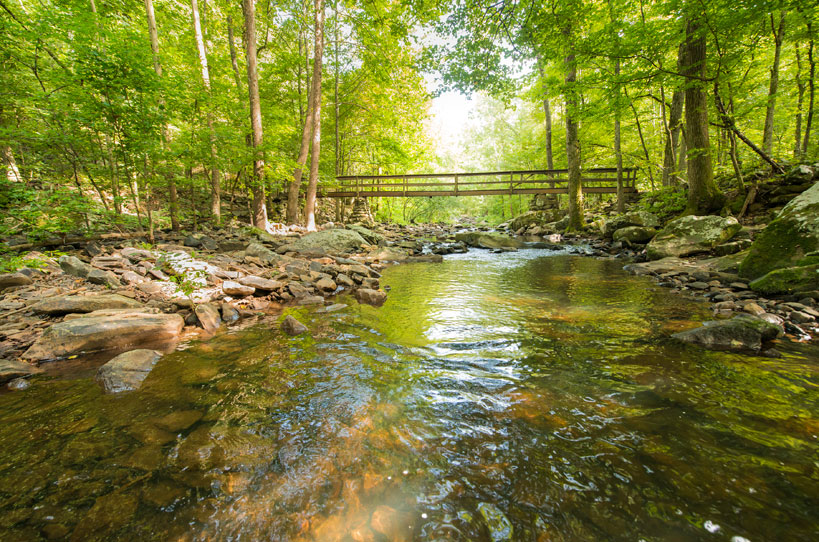
Photo by Arkansas Department of Parks and Tourism

Expect steep hills. Cave Mountain Road climbs 1,900 feet in one mile. Some sections of the route have two or three Category 2 climbs in a 50-mile stretch. The locals will tell you, “If they was to smooth out Newton County, It’d be bigger ‘n Texas.”  Many stretches of the route feel like a roller coaster.

The South Loop traverses the Ouachita Mountains and the Arkansas River Valley. In the Ouachitas, the route features sizable climbs and roller coaster ridges. These mountains consist of east to west running ridges and when the route travels east to west, expect to ride a roller coaster across the ridge. Most of the roads in the Ouachitas, except around Hot Springs, are gravel.

The Central Loop traverses the Boston Mountains of the Ozark Plateau, the Buffalo National River corridor, and the Arkansas River Valley. The Arkansas River Valley offers relatively flat terrain and lots of paved roads. The Ozark Mountains are a different story, featuring substantial climbs and roller coaster ridges.

The Northwest Loop climbs and drops between the Springfield Plateau and the Boston Mountains of the Ozark Plateau. Because it is on the Springfield Plateau, the western section of the loop is relatively flat. Even the steep hills are not very tall. The paved Razorback Regional Greenway makes for easy travel. Cycling east on the route the hills increase in size. Climbs become longer where the route moves from Springfield Plateau to the Boston Mountains.

Arkansas High Country Route - Main Route
Section Distance Elevation Total Climb Avg. Climb/mile
Total 1171.8 miles Minimum: 220 ft.
Maximum:2,650 ft.
90,720 ft. clockwise
90,455 ft. counterclockwise
77 ft. per mi. clockwise
77 ft. per mi. counterclockwise
1 500 miles Minimum: 220 ft.
Maximum:2650 ft.
33,650 ft. clockwise
33,460 ft. counterclockwise
67 ft. per mi. clockwise
67 ft. per mi. counterclockwise
2 671.8 miles Minimum: 250 ft.
Maximum:2515 ft.
57,070 ft. clockwise
56,995 ft. counterclockwise
85 ft. per mi. clockwise
85 ft. per mi. counterclockwise
Arkansas High Country Route - Alternates
Name Section Distance Total Climb Avg. Climb/mi
LOViT Singletack 1 46.1 miles 5,100 ft. clockwise
4,700 ft. counterclockwise
111 ft. per mi. clockwise
102 ft. per mi. counterclockwise
WOMBLE Singletrack 1 23.1 miles 2,200 ft. clockwise
1,870 ft. counterclockwise
95 ft. per mi. clockwise
81 ft. per mi. counterclockwise
Central Loop 2 434.2 miles 38,150 ft. clockwise
38,035 ft. counterclockwise
88 ft. per mi. clockwise
88 ft. per mi. counterclockwise
Northwest Loop 2 237.6 miles 18,920 ft. clockwise
18,960 ft. counterclockwise
80 ft. per mi. clockwise
80 ft. per mi. counterclockwise

Arkansas cyclists suggest that autumn and spring are the best times for riding (typically September to November and March to June). The dying leaves of autumn and the flowering dogwoods of spring are accompanied by moderate temperatures and flowing creeks. Summers are hot and humid. Don’t be surprised by 100°F days with high humidity. Heat exhaustion and dehydration are real dangers. Floods are most likely in the spring. The route uses a number of low-water crossings and small bridges. Do not attempt to cross a flooded stream, you’ll need to find a way around it.

In winter, storms most often lay down a sheet of ice instead of powder. Cycling on snow can be done, but not on ice. Furthermore, there is nothing colder than a 30°F rain. Hypothermia is an ever present danger in these conditions. Be prepared.

If you are accustomed to road-oriented bicycle travel, we recommend planning shorter days due to the nature of this route. It is one that requires greater exertions over shorter distances.

We discourage you from attempting to ride this route solo. In fact, a minimum group size of three is strongly recommended. If a rider is debilitated in the backwoods, you will want to have at least one person to stay with the injured/sick rider, and another to go for help. A growing number of backcountry travelers carry cell phones for such emergency situations, but be aware that reception is very spotty to nonexistent along portions of the route.

There are sections of the route where publicly available piped water sources are separated by over 50 miles. And in the dry season (May – October), the creeks may be empty. Carry a good water filter or chemical treatment, fill up at every opportunity, and plan ahead. Here is a list of usually reliable natural water sources: advcy.link/AHCwater.

Some campgrounds will charge a cyclist traveling alone less if they have hiker/biker sites, but often they will charge the price of a regular tent site, and that can easily be $10-$20/night. This route goes through several national forests and you are allowed to camp anywhere on national forest land as long as you “pack it in, pack it out.” Try to use an existing campsite — and especially an existing fire ring. The route also travels through multiple Wildlife Management Areas (WMAs) that are administered by both state and federal agencies, primarily the USFS and Arkansas Game and Fish. USFS dispersed camping rules apply to federal WMAs, but the state WMAs DO NOT allow dispersed camping. When you are in these areas make sure you camp in a designated camp area, many of which are indicated on the map.

You may also wish to sign up with Warmshowers, a reciprocal hospitality site for bicycle travelers, for other overnight options.

Shuttle options are limited in Arkansas, but growing. We have a list that can be found here: advcy.link/AHCshuttle.

Tough on Equipment

Riding this route can be hard on equipment. The weight of your gear exponentially multiplies the stress of riding steep, fast, rough downhills. Wheels, tires, and drivetrains (chains, cassettes, bottom brackets, chainrings) take a lot of abuse and may even need replacing. Suspension equipment on the bicycle helps to mitigate the abusive nature of the terrain. That said, nylon pivots of some full-suspension bikes wear out extremely fast. Suspension seatposts, good handlebar grips, and front-suspension forks help smooth out the miles of washboarded and chuckholed roads. Weighting a suspension fork with panniers works well, evens the weighting of the bike, and adds a little extra stress to the fork. Trailers would also work well and lighten the rear triangle of the bike. Don’t use trailers on any of the singletrack options.

Well-made camping gear is essential for the occasional nights of rain, cold, and dew. Sleeping bags should be rated to at least 20°F, and a sleeping pad or inflatable mattress is recommended to add comfort and warmth. Effort must be taken to keep your possessions dry. Pannier covers, dry bags, and plastic freezer bags all work well to keep the rain and dew off clothing and gear.

High-quality water treatment is mandatory. Advisably, carry one water-treatment system per person. Be it a water filter, chlorine dioxide drops, iodine tablets, or a UV water-treatment device, surface water should be ingested only after employing one of these proven water-treatment methods.

Route Highlights

Arkansas High Country Route Highlights

  • Little Rock, Section 1
  • Little Rock Central High School National Historic Site, Section 1
  • Hot Springs, Section 1
  • Hot Springs National Park, Section 1
  • Russellville, Section 2
  • Pilot Rock, Section 2
  • Arkansas Sphinx, Section 2
  • Ozark Highlands Trail, Section 2
  • Buffalo River Trail, Section 2
  • Upper Buffalo Headwaters Trails, Section 2
  • Buffalo National River, Section 2
  • Ozark Heritage Arts Center Museum, Section 2
  • Blanchard Caverns, Section 2
  • Conway, Section 2
  • Fayetteville, Section 2
  • Springdale, Section 2
  • Bentonville, Section 2

More Route Resources

TRAIL GUIDE

The South Loop traverses the Ouachita Mountains and the Arkansas River Valley. Major landmarks on the loop are Little Rock, Hot Springs, Albert Pike Recreation Area, Queen Wilhelmina State Park, Mount Magazine State Park, Dardanelle, Petit Jean State Park, and Conway.

In the Ouachitas, expect few services, little water, and spotty cell phone service. Load up with water and food at every opportunity and plan ahead. Take a water filter or chemical treatment for creek water. The route features big climbs and roller coaster ridges. Most of the roads in the Ouachitas (except around Hot Springs) are gravel.

These mountains consist of east to west running ridges. When the route travels east to west, expect to ride a roller coaster across the ridge. Sometimes – if you are lucky – the route will travel flat through one of the east to west running valleys. North to south portions of the route will be big climbs like the 1,500 foot climb up to Queen Wilhelmina State Park or the 2,000 foot climb up to Magazine Mountain State Park.

The Arkansas River Valley offers services every few miles and less climbing. There are cell phone towers everywhere. There are lots of paved roads in the Arkansas River Valley area.

The South Loop features two singletrack options, using the entire Lake Ouachita Vista Trail (LOViT), advcy.link/LOViT, and the southern portion of the Womble Trail, advcy.link/Womble. Both are International Mountain Bike Association (IMBA) EPIC trails, imba.com. The east end of the LOViT is rough. Rocky rough. Big climb rough. Of the riders who rated the difficulty of the trail on the IMBA website, 38% gave it an above average degree of difficulty. This difficulty will only increase when you add luggage to your bike. The Womble is much less rocky, but still features some steep climbs. We recommend that riders attack these singletrack sections on a mountain bike with tires tires at least 2 inches wide with knobby tread.

The South Loop traverses the Ouachita National Forest (501-321-5202) and the Ozark-St. Francis National Forest (479-964-7200). A supplemental forest visitor map can be obtained at the forest office, by visiting nationalforestmapstore.com or calling 971-263-3149. The visitor map is available digitally via Avenza Maps, avenzamaps.com. Download the free app, then search the Avenza Maps store for “Ouachita National Forest”. The app will display your location on top of the visitor map which can be helpful for traveling off of the South Loop.

REMOTE RIDING CONDITIONS

An Arkansawyer might tell you, “That route don’t go no where — It just runs around everywhere!” Indeed, the Arkansas High Country Route is designed to connect many of the interesting places in west-central Arkansas. It is not designed to connect points straight across the region. Rather, the route follows gravel and backwoods pavement in search of mountain views and swimming holes.

Most folk will find autumn and spring the best times for riding the route. The dying leaves of autumn and the flowering dogwoods of spring are accompanied by moderate temperatures and, usually, flowing creeks.

Summer is hot, humid, and abounds with ticks and chiggers. Don’t be surprised by 1000F days with high humidity. Heat exhaustion and dehydration are very real dangers for a cyclist in the Arkansas summer. Also, be alert to the possibility of a campfire burn ban. These are issued on a county-by-county basis. Authorities are unforgiving if you have a fire going during a ban.

There are sections of the route where publically available piped water sources are separated by over 50 miles. And in the dry season (May – October), the creeks may be empty. Carry a good water filter or chemical treatment. Fill up at every opportunity — especially in the summer. Plan where your next water fill-up will be. Here is a list of usually reliable natural water sources: advcy.link/AHCwater.

Autumn means deer hunting which means a lot of hunters in the woods. State law and good sense require cyclists (and anyone else in the woods) to wear a blaze orange vest and hat during deer season. Be aware, also, that Arkansas often has a short deer hunting season around Christmas. For dates see: advcy.link/ARhuntingdates. Additionally, in some years autumns are very dry, so heed the previous advice concerning water and campfire burn bans.

Visitors from northern states laugh at Arkansas’ inability to deal with snow. What they don’t understand is that our winter storms most often give us a sheet of ice instead of powder. You can ride on snow, but not on ice. Furthermore, there is nothing colder than a 330F rain. Hypothermia is an ever present danger in these conditions. Be prepared.

Floods are most likely in the spring. The route uses a number of low-water crossings and small bridges. Do not attempt to cross a flooded stream, you’ll need to find a way around it. Many hikers have lost their lives in Arkansas trying to ford a swollen stream that was not much more than knee deep. Flash floods can roar through a hollow (pronounced “holler” locally). Campers have been killed by flash floods washing away their camps in the middle of the night. If you choose to camp beside a creek, keep both eyes on the weather.

Since the route makes use of many ridge top roads, cyclists must be on the watch for lightning storms and tornadoes. These storms can arise in any season, but late winter and spring are the times to be most diligent.

Arkansas has black bears and mountain lions, but attacks are virtually unheard of. Cyclists are much more likely to suffer from attacks by mosquitos, ticks, and chiggers. Folks who wander into the woods in summer can expect to collect ticks by the dozen. Those who are really unlucky will stumble upon a bed of seed ticks — tiny tick larvae — or chiggers — tiny cousins of the tick. These little monsters know where you apply chamois butter, and they know how to get there. Pack your mosquito net in warm weather. The buffalo gnats can be just as bad as mosquitos. Finally, anyone visiting Arkansas in the green seasons (approximately April to October) should be able to recognize and avoid poison ivy.

Concerning the bipedal animals of Arkansas, watch out for logging trucks. They are big, and they are in a hurry. Always ride on your side of the road and be ready to yield to them. Also be ready to meet an ATV that is going too fast around a blind corner. Horsemen also use the back roads. Horses, generally, hate bicycles. Be an ambassador for cycling and slow down or stop so you don’t send an equestrian flying into the brush. Hill folks are serious about trespassing so don’t stealth camp. Ask permission or camp on public land. Double check your maps and your electronics to make sure you are on the public side of a property line.

Just as piped water is scarce on the route, so are services. Expect to ride 100 miles between convenience stores, and 500 miles between bike shops. Businesses in small towns may be unreliable — they might have limited hours or they can open and close unexpectedly. Carry extra tubes, a pump, tools, and parts to fix your bike if necessary. A first aid kit is a must and carry more food than you think you will need. There are sections of the route with no cell phone service. Smart cyclists will ride with a group. If there is an accident, there will be someone to help.

Just to make things interesting, Arkansas has “dry” counties, meaning adults can’t buy alcohol in those counties. Here is a link to a map showing dry and wet counties: advcy.link/ARalcoholsales.

Since the main route is roughly 50% gravel and 50% pavement, what bike are you going to ride? Some riders, who are in a hurry, will choose a race geometry gravel bike like a Salsa Warbird. Those who choose comfort over speed will elect for full suspension or fat tires to pad the ride. Much of the gravel roads are easily ridden, but there are areas with washboarding and cathead boulders. A minimum of 37 mm tires with some tread is highly recommended.

Arkansas counties and the U.S. Forest Service (USFS) are kept busy resetting and replacing stolen or shot-up signs. Expect to find a few locations where our narrative refers to a sign that no longer exists. Please alert us when you encounter a missing sign so we can update our narratives.

Practice low impact camping. Familiarize yourself with IMBA’s Rules of the Trail, advcy.link/IMBArules. The route passes through or close to many campgrounds owned by the state, federal government, and private citizens. Using these facilities will minimize your impact. The USFS allows dispersed camping in the national forests. Try to use an existing campsite — and especially an existing fire ring. The route travels through multiple Wildlife Management Areas (WMAs) that are administered by both state and federal agencies, primarily the USFS and Arkansas Game and Fish. USFS dispersed camping rules apply to federal WMAs, but the state WMAs DO NOT allow dispersed camping. When you are in these areas make sure you camp in a designated camp area, many of which are indicated on the map. They may be signed but remember what we just said about signs! More information about camping in WMAs can be found here: advcy.link/ARWMAs.

Shuttle options are limited in Arkansas, but growing. We have a list that can be found here: advcy.link/AHCshuttle. If you learn that a new company has started or an old company longer exists, let us know so we can keep things up to date.

It is said that an adventure is suffering with a good attitude. This route will give you the opportunity to have an adventure. Start with some short overnight bikepacking trips and learn how to use all your gear. You might even get a buddy to drive a SAG truck on your first excursions. Then stretch yourself. Add more miles and ride for a week. When you have strengthened both your legs and your confidence, ride all three loops. Y’all give us a call when you get done. Let’s talk about your adventure!

LOViT Singletrack Option

6.7 miles shorter than the main route, this rocky and steep singletrack option offers excellent ridge riding and breathtaking views of Lake Ouachita. The trail is well-signed and well-blazed. Listed by IMBA as an “EPIC” trail.

Womble Singletrack Option

12.1 miles longer than the main route, this rugged singletrack option follows a narrow track through the forest before ascending the steep ridges of Mauldin Mountain. The trail is well-signed and well-blazed. Listed by IMBA as an “EPIC” trail.

Updated: Sep 10, 2021

TRAIL GUIDE

Central Loop

The Central Loop traverses the Arkansas River Valley and the Boston Mountains of the Ozark Plateau. Major landmarks on the loop are Little Rock, Conway, Petit Jean State Park, Dardanelle/Russellville, Oark, Ponca, Jasper, Marshall, Mountain View, and Woolly Hollow State Park.

The Arkansas River Valley, in the southeast part of the loop offers relatively flat terrain and lots of paved roads. There are towns with multiple services every few miles, and plenty of cell phone towers.

The Ozarks are a different story. Stores, cell towers and piped water are scarce. Load up with water and food at every opportunity and plan ahead. Take a water filter or chemical treatment for creek water. The route features big climbs and roller coaster ridges. Most of the roads in the Ozark Mountains are gravel. There are a few sections of highway pavement in the north.

West of Silver Hill, in the Buffalo National River corridor, the ford of Calf Creek on Peter Cave Rd. is impassable in high water. Heading clockwise, inquire locally in the town of Snowball to determine whether a detour east on SR 74 to US 65 is required. Counter-clockwise, check in Marshall. Otherwise, this is often a dry ford over gravel.

The Central Loop passes very closely by two International Mountain Bike Association (IMBA) EPIC trail systems, Upper Buffalo Headwaters, advcy.link/BuffHead, and Syllamo, advcy.link/Syllamo. Both of these trail networks are singletrack, and include some very steep, rocky riding. We recommend that riders attack these singletrack sections on a mountain bike with tires at least 2 inches wide with knobby tread. For more info on IMBA, see imba.com.

The Central Loop traverses the Ozark-St. Francis National Forest (479-964-7200). Supplemental forest visitor maps can be obtained at the forest office, by visiting nationalforestmapstore.com or calling 971-263-3149. Visitor maps are available digitally via Avenza Maps, avenzamaps.com. Download the free app, then search the Avenza Maps store for “Ozark National Forest (East)”, “Ozark National Forest (West)”, and “Ozark National Forest, Sylamore District”. The app will display your location on top of the visitor map which can be helpful for traveling off of the route.

Northwest Loop

The Northwest Loop climbs and drops between the Springfield, Salem, and Boston Plateaus of the Ozark Mountains. Major landmarks on the loop are Bentonville, Eureka Springs, Oark, White Rock Mountain, and Fayetteville.

Because it is on the Springfield Plateau, the western section of the loop is relatively flat. Even the steep hills are not very tall. The paved Razorback Regional Greenway, advcy.link/razorbackgrnway, makes for easy travel, lots of services–including bike shops–and plenty of phone service.

As one moves east on the route, the services are fewer, and the hills get bigger. The climbs are increasingly big where the route moves from Springfield to either the Salem or Boston Plateaus. The rugged mountains offer few services, dry mountain tops, and gravel roads. Cell phone service is especially lacking in the deep hollows (pronounced “holler” locally).

This Loop passes very closely by the Upper Buffalo Headwaters, advcy.link/BuffHead, an International Mountain Bike Association (IMBA) EPIC trail system. See the description under the Central Loop Trail Guide for more information.

The Northwest Loop traverses the Ozark-St. Francis National Forest (479-964-7200) and includes a short distance in the Mark Twain National Forest (573-364-4621) in Missouri. Supplemental forest visitor maps can be obtained at the forest office, by visiting nationalforestmapstore.com or calling 971-263-3149. Visitor maps are available digitally via Avenza Maps, avenzamaps.com. Download the free app, then search the Avenza Maps store for “Ozark National Forest (East)”, “Ozark National Forest (West)”, “Ozark National Forest, Sylamore District”, and “Mark Twain National Forest – Cassville Ranger District”. The app will display your location on top of the visitor map which can be helpful for traveling off of the route.

REMOTE RIDING CONDITIONS

An Arkansawyer might tell you, “That route don’t go no where — It just runs around everywhere!” Indeed, the Arkansas High Country Route is designed to connect many of the interesting places in west-central Arkansas. It is not designed to connect points straight across the region. Rather, the route follows gravel and backwoods pavement in search of mountain views and swimming holes.

Most folk will find autumn and spring the best times for riding the route. The dying leaves of autumn and the flowering dogwoods of spring are accompanied by moderate temperatures and, usually, flowing creeks.

Summer is hot, humid, and abounds with ticks and chiggers. Don’t be surprised by 100° F days with high humidity. Heat exhaustion and dehydration are very real dangers for a cyclist in the Arkansas summer. Also, be alert to the possibility of a campfire burn ban. These are issued on a county-by-county basis. Authorities are unforgiving if you have a fire going during a ban.

There are sections of the route where publically available piped water sources are separated by over 50 miles. And in the dry season (May – October), the creeks may be empty. Carry a good water filter or chemical treatment. Fill up at every opportunity — especially in the summer. Plan where your next water fill-up will be. Here is a list of usually reliable natural water sources: advcy.link/AHCwater.

Autumn means deer hunting which means a lot of hunters in the woods. State law and good sense require cyclists (and anyone else in the woods) to wear a blaze orange vest and hat during deer season. Be aware, also, that Arkansas often has a short deer hunting season around Christmas. For dates see: advcy.link/ARhuntingdates. Additionally, in some years autumns are very dry, so heed the previous advice concerning water and campfire burn bans.

Visitors from northern states laugh at Arkansas’ inability to deal with snow. What they don’t understand is that our winter storms most often give us a sheet of ice instead of powder. You can ride on snow, but not on ice. Furthermore, there is nothing colder than a 33° F rain. Hypothermia is an ever present danger in these conditions. Be prepared.

Floods are most likely in the spring. The route uses a number of low-water crossings and small bridges. Do not attempt to cross a flooded stream, you’ll need to find a way around it. Many hikers have lost their lives in Arkansas trying to ford a swollen stream that was not much more than knee deep. Flash floods can roar through a hollow (pronounced “holler” locally). Campers have been killed by flash floods washing away their camps in the middle of the night. If you choose to camp beside a creek, keep both eyes on the weather.

Since the route makes use of many ridge top roads, cyclists must be on the watch for lightning storms and tornadoes. These storms can arise in any season, but late winter and spring are the times to be most diligent.

Arkansas has black bears and mountain lions, but attacks are virtually unheard of. Cyclists are much more likely to suffer from attacks by mosquitos, ticks, and chiggers. Folks who wander into the woods in summer can expect to collect ticks by the dozen. Those who are really unlucky will stumble upon a bed of seed ticks — tiny tick larvae — or chiggers — tiny cousins of the tick. These little monsters know where you apply chamois butter, and they know how to get there. Pack your mosquito net in warm weather. The buffalo gnats can be just as bad as mosquitos. Finally, anyone visiting Arkansas in the green seasons (approximately April to October) should be able to recognize and avoid poison ivy.

Concerning the bipedal animals of Arkansas, watch out for logging trucks. They are big, and they are in a hurry. Always ride on your side of the road and be ready to yield to them. Also be ready to meet an ATV that is going too fast around a blind corner. Horsemen also use the back roads. Horses, generally, hate bicycles. Be an ambassador for cycling and slow down or stop so you don’t send an equestrian flying into the brush. Hill folks are serious about trespassing so don’t stealth camp. Ask permission or camp on public land. Double check your maps and your electronics to make sure you are on the public side of a property line.

Just as piped water is scarce on the route, so are services. Expect to ride 100 miles between convenience stores, and 500 miles between bike shops. Businesses in small towns may be unreliable–they might have limited hours or they can open and close unexpectedly. Carry extra tubes, a pump, tools, and parts to fix your bike if necessary. A first aid kit is a must and carry more food than you think you will need. There are sections of the route with no cell phone service. Smart cyclists will ride with a group. If there is an accident, there will be someone to help.

Just to make things interesting, Arkansas has “dry” counties, meaning adults can’t buy alcohol in those counties. Here is a link to a map showing dry and wet counties: advcy.link/ARalcoholsales.

Expect steep hills. Cave Mountain Road climbs 1,900 feet in one mile. Some sections of the route have two or three Category 2 climbs in a 50-mile stretch. The locals will tell you, “If they was to smooth out Newton County, it’d be bigger ‘n Texas.” Many stretches of the route feel like a roller coaster.

Since the main route is roughly 50% gravel and 50% pavement, what bike are you going to ride? Some riders, who are in a hurry, will choose a race geometry gravel bike like a Salsa Warbird. Those who choose comfort over speed will elect for full suspension or fat tires to pad the ride. Much of the gravel roads are easily ridden, but there are areas with washboarding and cathead boulders. A minimum of 37 mm tires with some tread is highly recommended.

Arkansas counties and the U.S. Forest Service (USFS) are kept busy resetting and replacing stolen or shot-up signs. Expect to find a few locations where our narrative refers to a sign that no longer exists. Please alert us when you encounter a missing sign so we can update our narratives.

Practice low impact camping. Familiarize yourself with IMBA’s Rules of the Trail, advcy.link/IMBArules. The route passes through or close to many campgrounds owned by the state, federal government, and private citizens. Using these facilities will minimize your impact. The USFS allows dispersed camping in the national forests. Try to use an existing campsite — and especially an existing fire ring. Backcountry camping is allowed in the Buffalo National River following these rules: advcy.link/backcountrycamping. The route travels through multiple Wildlife Management Areas (WMAs) that are administered by both state and federal agencies, primarily the USFS and Arkansas Game and Fish. USFS dispersed camping rules apply to federal WMAs, but the state WMAs DO NOT allow dispersed camping. When you are in these areas make sure you camp in a designated camp area, many of which are indicated on the map. They may be signed but remember what we just said about signs! More information about camping in WMAs can be found here: advcy.link/ARWMAs.

Shuttle options are limited in Arkansas, but growing. We have a list that can be found here: advcy.link/AHCshuttle. If you learn that a new company has started or an old company longer exists, let us know so we can keep things up to date.

It is said that an adventure is suffering with a good attitude. This route will give you the opportunity to have an adventure. Start with some short overnight bikepacking trips and learn how to use all your gear. You might even get a buddy to drive a SAG truck on your first excursions. Then stretch yourself. Add more miles and ride for a week. When you have strengthened both your legs and your confidence, ride all three loops. Y’all give us a call when you get done. Let’s talk about your adventure!

Updated: Apr 18, 2019

Updates to Recently Released Maps

If you are planning a bike tour, be sure to get the most recent map updates and corrections for your route by selecting the route, and the appropriate section(s), from the drop-down menu below.

Over time maps become less useful because things change. Every year Adventure Cycling’s Routes and Mapping Department create map updates and corrections for every map in the Adventure Cycling Route Network, which now totals 52,047 miles. With the help of touring cyclists like you, we receive updates on routing, services, camping, and contact information. Until we can reprint the map with the new information, we verify the suggested changes and publish corrections and updates here on our website.

PLEASE NOTE: Covid has been particularly hard on the small businesses along our routes. While we do our best to keep the maps and these online updates current, you may encounter more closed businesses and longer stretches with limited or no services.

Refer to these updates for the most current information we have and submit reports of changes to the Route Feedback Form for the cyclists coming after you.

NOTE: Map updates and corrections only pertain to long term changes and updates. For short term road closures, please see the Adventure Cycling’s Routes Temporary Road Closures discussion in our Forums.