UGRR Detroit Alternate
Due to limited resources, the paper map version of this route has been discontinued. This route is still available digitally.
Route Options
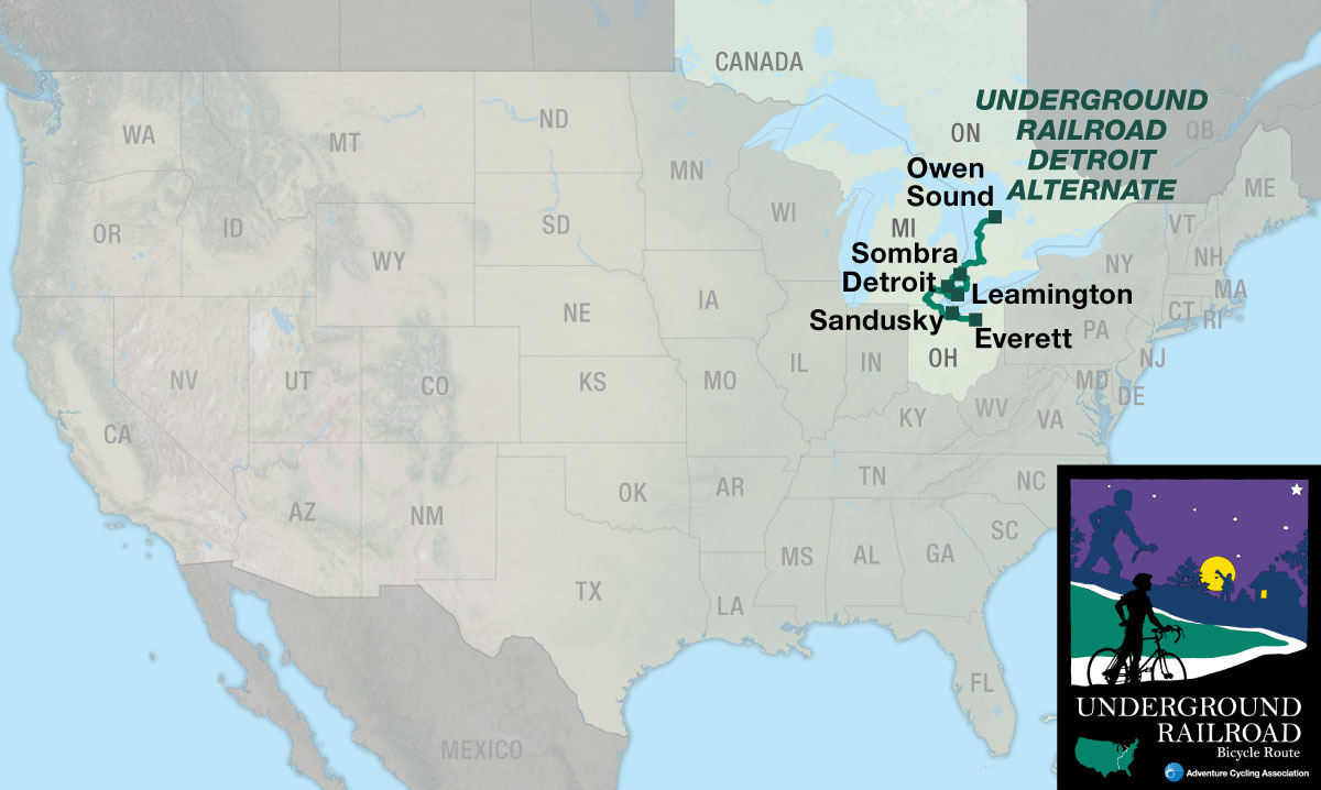
The Underground Railroad Bicycle Route (UGRR) memorializes the Underground Railroad, a network of clandestine routes by which African freedom seekers attempted to escape slavery before and during the Civil War. This page describes the 564.7-mile Underground Railroad Detroit Alternate route from Everett, OH, to Owen Sound, Ontario. You may also be interested in the main Underground Railroad Bicycle Route (UGRR), the UGRR Pittsburgh Spur, or the day-trip rides in Ripley, Ohio (PDF).
Take another legendary path to freedom.
The 564.7-mile Underground Railroad Detroit Alternate provides alternate routing, and a host of new historic sites, for cyclists traveling the Underground Railroad Bicycle Route (UGRR) between Everett, Ohio, and Owen Sound, Ontario. Departing from the main Underground Railroad route in Everett, the Detroit Alternate guides cyclists through Toledo and Detroit, around Lake St. Clair, tracing the shoreline of Lake Huron before heading to Owen Sound. The maps also provide a ferry option across Lake Erie from Sandusky, Ohio, through Windsor, Ontario.
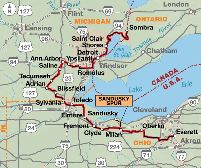
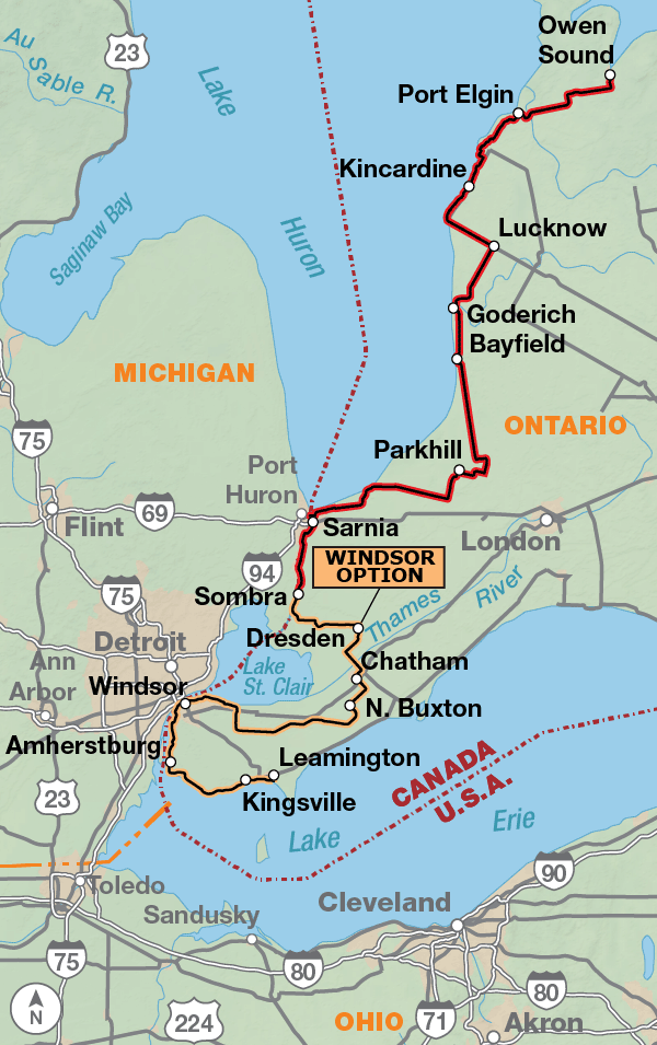
This alternate begins in Everett, Ohio, a tiny community that is located on Section 4 of the main route. It takes cyclists around the western side of Lake Erie through historically rich Michigan. There are many sites to visit in the towns that the route goes through. Oberlin is home to Oberlin College, among the first colleges in the United States to admit African-American students. Sites in town include the Westwood Cemetery, the final resting place for many abolitionists and freedom seekers; and the First Church of Oberlin, which served as the headquarters of the Oberlin Anti-Slavery Society. It was also here that memorial services were held for John Copeland and Shields Green, two men who were hung for their participation in abolitionist John Brown’s 1859 raid on the federal arsenal in Harpers Ferry. Not far east of Oberlin is Hudson (on section 4), Brown’s boyhood home. The early abolitionist movement ran strong in Hudson, which in 2000 became the first town in northern Ohio to receive a state Underground Railroad historical marker, commemorating the community’s involvement in the anti-slavery movement. In Michigan, the route becomes much more urban. Because there is no bicycle-friendly connection between Detroit and Windsor the route crosses into Canada north of these cities, which were both important sites to freedom seekers. You have an option though, which could also become a loop on its own. From the Sandusky Spur, you can cross Lake Erie via ferry and follow the 162-mile Windsor Option. The route goes northwest along the shoreline to Windsor, where many settled after their escape from the U.S. Continuing northeast it reconnects to the route just northwest of Wallaceburg, Ontario. The route then heads north through rural countryside, visiting several more Underground Railroad sites before reaching Owen Sound, the terminus of the main route, located on the southern side of Lake Huron’s Georgian Bay.
Photo by Ginny Sullivan
Northwestern Ohio and southeastern Michigan are mainly flat. You will find a few rolling hills between Adrian, Michigan and the outskirts of Detroit. After crossing the St. Clair River into Ontario, Canada, the route becomes hillier, even when riding along Lake Huron. There is a big descent riding to the route’s terminus at Owen Sound.
| UGRR Detroit ALT - Main Route | ||||
|---|---|---|---|---|
| Section | Distance | Elevation | Total Climb | Avg. Climb/mile |
| Total | 564.7 miles | Minimum: 570 ft.Maximum:1205 ft. | 11,525 ft. north bound11,705 ft. south bound | 20 ft. per mi. north bound21 ft. per mi. south bound |
| 1 | 340.8 miles | Minimum: 570 ft.Maximum:1,205 ft. | 5,480 ft. north bound5,645 ft. south bound | 16 ft. per mi. north bound17 ft. per mi. south bound |
| 2 | 223.9 miles | Minimum: 575 ft.Maximum:955 ft. | 6,045 ft. north bound6,060 ft. south bound | 27 ft. per mi. north bound27 ft. per mi. south bound |
| UGRR Detroit ALT Alternates | ||||
|---|---|---|---|---|
| Name | Section | Distance | Total Climb | Avg. Climb/mile |
| Sandusky Spur | DET ALT 1 | 14.8 miles | 190 ft. north bound280 ft. south bound | 13 ft. per mi. north bound19 ft. per mi. south bound |
| Windsor Option | DET ALT 2 | 162.1 miles | 1,225 ft. north bound1,220 ft. south bound | 8 ft. per mi. north bound8 ft. per mi. south bound |
This route can be ridden from mid-spring to mid-fall (typically April to October). Some cyclists may want to do the northern portions of it during the colors of autumn. If you do, call ahead to verify campground availability because many close after Labor Day.
Many UGRR activities historically took place in what were then villages and small towns, which became large cities. Due to this growth, the route passes through several major metropolitan areas and thus involves serious urban cycling. These large cities are generally devoid of campgrounds.
In Ohio, the route makes use of two paved rail trails. The North Coast Inland Trail between Oberlin and the Lorain/Huron County line, and again between Clyde and Elmore; and the University Trail in the suburbs of Toledo. These trails are shorter and safer than adjacent highways.
The route changes dramatically from urban to rural at the Ohio/Michigan state line. Cyclists are advised to stay on the marked route in rural Michigan as there are many unpaved secondary roads. Also, the state and U.S. highways carry considerable truck traffic and do not have paved shoulders. The route uses the Kiwanis Trail between Adrian and Tecumseh.
Note that Michigan does not allow left turns at signalized intersections from a highway having a center median. Instead, left turning traffic proceeds a couple hundred yards beyond the intersection and then makes a U-turn at a sometimes-signalized crossover. Cyclists should make left turns as a pedestrian.
The Walpole Algonac Ferry between Algonac, Michigan and Walpole Island, Ontario operates from 6:50 A.M. to 10:00 P.M.
Although none of the major highways in Ontario have paved shoulders, the speed limit outside of urban areas is 80km/hr (50 mi/hr) and motorists generally abide by that limit.
Rural secondary roads throughout southwest Ontario are often gravel. The route has been carefully researched to avoid those roads. What may look like a tempting shortcut down a paved road may become a miserable ride on a gravel road. Cyclists are advised to stay on the route.
It is worthwhile to spend a few minutes in Sarnia at the park under the Blue Water Bridge connecting Canada and the United States. It is where all of the water from the upper Great Lakes funnels into the narrow St. Clair River. Bicycles are not allowed on the Blue Water Bridge.
North of Sarnia the route goes inland and then continues mostly as an inland route to avoid the relatively heavy traffic and trucks on PR 21. This highway is the major tourist and commercial route between Sarnia and Owen Sound. The consequence of this routing is that there are few on-route services outside of towns and cities. Cyclists wishing to use services on PR 21 should return to the UGRR route to continue their trip and avoid the traffic on PR 21.
The 14.8-mile Sandusky Spur is the connection to the ferry across Lake Erie to Ontario, Canada, and the Windsor Option on section 2. All ferries to Canada from Sandusky, Ohio, stop at Pelee Island which is the Port of Entry/Customs to Canada. Sandusky is the Port of Entry/Customs to the United States.
The area near Sandusky is home to Cedar Point, one of the largest amusement parks in the country, and is therefore a busy summer tourist destination. Bicycles are not allowed on the Cedar Point Causeway and Bridge.
The 162.1-mile Windsor Option follows the Lake Erie coastline through the city of Windsor and visits several notable sites. You need to consult the ferry schedule before crossing Lake Erie as the schedule varies by month and day of the week. Ferries arrive and depart from Kingsville or Leamington at different times of the year.
The route from the ferry to Windsor provides views of Lake Erie and especially the Detroit River. The multi-use path between the Ambassador Bridge and the north side of Windsor is imbedded in a riverfront park and is very pleasant cycling. Bicycles are not allowed on the Ambassador Bridge or in the Detroit/Windsor Tunnel.
Some campgrounds will charge a cyclist traveling alone less if they have hiker/biker sites, but often they will charge the price of a regular tent or RV site, and that can easily be $10-$40/night. The maps list churches that have opened their doors to cyclists, but they aren’t all that closely spaced. If you’re friendly and ask around, you can often get yourself invited to camp in a yard. In the U.S. our routes sometimes go through national forests (moreso in the west) and you are allowed to camp anywhere on national forest land as long as you “pack it in, pack it out.” Many city parks are free to camp in.
You may also wish to sign up with Warmshowers, a reciprocal hospitality site for bicycle travelers, for other overnight options.
Route Highlights
UGRR Detroit Alternate Highlights – Section 1: Oberlin, OH to Marine City, MI
Medina, OH
- Blake House was an Underground Railroad station which harbored freedom seekers in the barn. Tours by appointment.
Oberlin, OH
- Oberlin Heritage Center showcases the abolitionist and Underground Railroad history of the community. Guided and self-guided walking and biking tours available. Includes tours of the Monroe House, Jewett House, and Little Red Schoolhouse which tell the story of this community from 1833-1930.
- Downtown Oberlin — A historic district full of beautifully preserved homes and businesses, many with direct links to the Underground Railroad.
- First Church in Oberlin* — Built in 1842, this church served as the meeting place for the Oberlin Anti-Slavery Society and was the site of the memorial service for John Copeland and Shields Green who were hanged for their participation in John Brown’s raid on Harper’s Ferry. Call 440-775-1711 for tour.
- Oberlin College was the first college in the United States to regularly admit African American students (1835) and is also the oldest continuously operating coeducational institution. Learn the history of this college dedicated to equality in education based upon Christian values.
Sandusky, OH
- City of Sandusky, OH. Because of its location on Lake Erie, Sandusky was a major terminal on the UGRR. It is known by the code name “Hope.”
- Follet House Museum , 404 Wayne St. Was a famous safe house and is now an UGRR museum and on the National Register of Historic Landmarks.
- Second Baptist Church, 315 Decatur St. Was founded in 1849 by a group of seven former slaves as the Zion Baptist Church. Prior to the Civil War the church was reorganized under the name First Anti-Slavery Baptist Church. As one of the most active stations in Sandusky, many refugee slaves were hidden, fed, and clothed here. The present church (circa 1930) is constructed around the original church’s wooden framework and, along with the parsonage, is listed on the National Register of Historic Places.
- Many homes in the Sandusky area served as Underground Railroad stations.
- Sloane House* at 403 E. Adams St. A judge and abolitionist, Sloane was instrumental in helping slaves escape even at his own peril.
- George Barney House* at 422 E. Washington St. became well known as a safe house around 1858. Many believe Barney employed fugitives at the foundry he co-owned.
- Goodwin House* at 327 Hancock St. Goodwin was a local lawyer and active agent on the Underground Railroad.
- McGee House* at 536 E. Washington St. Captain Thomas McGee was a master on several ships sailing on Lake Erie and was instrumental in helping fugitive slaves escape to Canada from the Sandusky Docks.
- Merry House* at 330 E. Adams St. Henry Merry was a master builder and contractor who began employing slaves in 1836, and his home, built in 1852, was a well know safe house.
- Reynolds House* on the northeast corner of Jackson St. and Madison St. An African-American carriage maker and Underground Railroad conductor, he once drove fugitives across frozen Lake Erie in a sleigh.
- Root House* at 231 E. Adams St. Root was a radical abolitionist who served as mayor of Sandusky, state senator, and later congressman.
- Big Four Dock* is one of the major launching points for freedom seekers going into Canada. The dock sits at the foot of Lawrence St., near present day boat ramp at the Sandusky Docks. Many slaves hid in rail cars. The dock is described in Uncle Tom’s Cabin.
- Path to Freedom Sculpture* in Facer Park on the corner of Hancock Rd. and Shoreline Rd. This is a life size representation of an Afro-American man, woman, and child. Eight hundred feet of chain was used in the creation of the sculpture.
Sylvania, OH
- Sylvania Historical Village & Heritage Center Museum is a living history museum with costumed interpreters working in a blacksmith shop, rail depot, 1840s log home, schoolhouse, and museum.
- Lathrop House at Harroun Community Park is managed by the Metropolitan Park District of Toledo. The Friends of Lathrop, the City of Sylvania, and countless volunteers have worked to preserve the house. Lathrop, as a representative to the Ohio State Legislature, pushed to revise Ohio school laws so black children could receive an education. Furthermore, he worked to establish laws that gave slaves the right to appear in court and other legal protections. Secretly, he took action to assist slaves in finding freedom in Canada.
Blissfield, MI
- David Carpenter House (now The Hathaway House restaurant) was home to one of the Carpenter brothers who were members of the Blissfield Anti-Slavery Society, part of the Underground Railroad network connected to Toledo. The Blissfield Anti-Slavery Society officers constituted what was called a “Committee of Vigilance.”
Adrian, MI
- Lenawee County and Adrian, MI, are part of a region known as the Old Northwest, and in the 1830’s, with a growing Quaker, Presbyterian, and Baptist population, embraced the antislavery movement and remained a stronghold up to the time of the Civil War. Though not all of the following homes and markers are on the route, all are worth learning about while you’re in the region.
- Lenawee County Historical Museum houses thousands of documents relating to business, government, religion, education, railroads, the military, the Underground Railroad, prominent citizens, and many other subjects of local interest.
- Thomas and Elizabeth Chandler Home*. Hazelbank Farm, near Valley Rd. on Breckel Highway was home to Thomas Chandler, who served as the President of the Michigan State Anti-Slavery Society several times and was involved in Lenawee and Michigan radical antislavery activities in the 1830s and 1850s. He worked for The American Freeman. His younger sister, Elizabeth, authored the poem “Slave Ship” at age 18. She also wrote for the “Ladies’ Repository” section of the Genius of Universal Emancipation, wherein she demanded better treatment of Native Americans and the emancipation of slaves. Chandler introduced one of the most famous abolitionist images, “Am I not a Woman and a Sister,” which William Lloyd Garrison adopted for his abolitionist paper, The Liberator, and which Sojourner Truth adopted as the slogan for her famous 1851 speech. Her articles, poems, and letters were gathered together by Benjamin Lundy into two books, the proceeds of which went towards abolitionist causes. She founded the first women’s antislavery society, the Logan Female Antislavery Society in 1832.
- Warren Gilbert Home* on Gilbert Highway. Warren Gilbert settled on the Gilbert homestead in the 1840’s as a staunch abolitionist, a champion of women’s rights and an advocate of temperance. He strove to advance these causes. His home was one of the stations of the Underground Railroad, and the family helped many fugitives on their way to freedom.
- Dr. Woodland Owen House, 405 N. Winter St. Currently the location of the Lenawee Sheriff’s office and jail. Dr. Woodland Owen was an Englishman who immigrated to America and settled in Adrian in 1848. His Italianate home was more than likely a station on the Underground Railroad towards the end of the Civil War. Dr. Owen’s entire family was active in the antislavery cause. Woodland and Jane Owen were listed as “Constant Anti-Slavery worker[s]” in the register of supporters of the Michigan Anti-Slavery Society from the 1850s.
- Laura Haviland statue, 100 E Church St. Haviland was so effective in her abolitionist activities and work for the Underground Railroad that Southern slave owners offered a $3,000 reward for her capture. In 1834, she and the other leading antislavery Quakers of Raisin Township, including her husband Charles, her father Daniel Smith (later elected as one of the Vice-Presidents of the Michigan Anti-Slavery Society), her mother Sene Smith, and fifteen others withdrew from their Quaker meetings over differences regarding slavery. She later joined the Wesleyan Methodists. Haviland and her husband founded a free school for the children of former slaves and helped establish the Refugee Home Society, which offered temporary housing to freedom seekers in Windsor, ON.
- Raisin Valley Friends Church & Cemetery is home to a historical marker recognizing the first pastor of the Adrian Friends Meetinghouse (1835-1841), Daniel Smith, whose Quaker abolitionist daughter Laura Smith Haviland is interred in the church cemetery. The congregation was part of the New York Yearly Meeting until 1869 and then became part of the Ohio Yearly Meeting. Friends worshipped in this building for the first time on June 11, 1835. This Raisin Valley Congregation is Michigan’s oldest surviving Friends Organization.
- Sutton House*, 3301 Sutton Rd. A small room in the basement of this red brick house was used to hide runaways in the 1840s, when it was owned by farmer Samuel Brown. There was a false door used to get into the basement, and another to let people into the house from the outside. Fugitives were hidden underneath the wooden floorboards. This house is now owned by Wacker Silicones Corp.
Albion, MI (off route)
- Albion* would make a nice side trip as it was a major stopping point on the Underground Railroad with several homes that served as stations and many anti-slavery activists in residence.
- Juliet Calhoun Blakeley House* no longer stands, but Juliet Calhoun Blakeley (1818-1920) allowed her home to serve as one of the local hiding stations on the Underground Railroad. The entire Blakely family was involved in the operation, hiding fugitives in the bottom of their wagon, under bags of grain or covered with ears of corn, and transporting them along the predetermined route.
- Samuel Snyder House* on the north side of the 800 block of Irwin Ave. Samuel Snyder (1811-1857) and his wife Deborah Whipple (1819-1908) were Methodists and supporters of the anti-slavery movement. They allowed their land — surrounded by woods and swamps ideal for hiding — to be used as the very first stop for the Underground in Albion.
- Charles Taylor House*, 1400 E. Michigan Ave. This was the house of local “stationmaster,” Rev. Charles Taylor (1804-1848). It is believed that this house was used as an Underground Railroad site with the help of Taylor’s father, David. The house contained a small closet-sized room over the stairwell that was accessible only by a narrow ledge, where it is assumed fugitive slaves would hide before venturing to Detroit and Canada.
Marshall, MI (off route)
- Crosswhite Marker* at E. Michigan Ave. and E. Mansion St. is off route but might be worth a side trip due to the significant history associated with Adam Crosswhite. In 1847 Adam Crosswhite (1799-1878) and his family were tracked to Marshall by the local Sheriff and four armed Kentuckians, one of which was his former owner. While the court proceedings were ongoing, the Crosswhite family escaped to Buxton, Ontario, Canada via the Detroit railroad. A lawsuit based upon the Fugitive Slave Act of 1793 ensued, resulting in the former owner awarded damages of $1,926. In response, George DeBaptiste, William Lambert, and many other prominent abolitionists became even more committed to the Underground Railroad cause.
- Oliver C. Comstock, Jr. House*. Dr. Comstock, Jr. (1806-1895) is perhaps best known as one of the abolitionists involved in the Crosswhite Case. In 1847, he and several other prominent Marshall citizens were convicted and fined for the conspiracy to harbor the fugitive slave family of Adam Crosswhite.
- Other sites include the Jabez Fitch House* at 310 N. Kalamazoo St. and the Charles T. Gorham Marker* at 124 W. Michigan Ave.
Saline, MI
- First Presbyterian Church*. Pastor J.G. Kanouse was the first pastor of this church, founded by a group opposed to slavery. Kanouse was an Underground Railroad operator.
- Lodi Cemetery* at corner of Ann Arbor Rd. and Textile Rd. John Lowry burial site, a noted abolitionist and Underground Railroad station agent.
- W. W. Harwood House and Cemetery* is a private residence that was a station on the Underground Railroad, along with several neighboring houses. Many freedom seekers traveled along this road to safety in cities such as Ann Arbor, Ypsilanti, and Detroit, or on to Canada. The cemetery is located behind the house at the intersection of Textile Rd. and Campbell Rd. The original 1840s William Harwood Farm remains in the family and has a hiding place in the basement. Listed on the NPS Network to Freedom. Located off route 2.3 miles east of the intersection of Textile Rd. and Lohr Rd.
Ann Arbor, MI
- Michigan Anti-Slavery Society Historical Marker. Five years before becoming the home of the Signal of Liberty, Ann Arbor hosted the first meeting of the Michigan State Anti-Slavery Society on November 10 and 11, 1836 at the First Presbyterian Church. Seventy-five antislavery activists from six Michigan counties attended.
- Guy Beckley House, a private residence, was the home of the Reverend Guy Beckley, one of Ann Arbor’s most important Underground Railroad sites. Reverend Beckley lectured across the state, published the Signal of Liberty newspaper, and served on the Executive Committee of the Michigan Anti-Slavery Society. An Underground Railroad conductor from Wisconsin led Caroline Quarlls to Beckley’s house on her escape to Canada. Other self-emancipators were helped by the Rev. Beckley, including Robert Coxe.
Ypslanti, MI
- Elijah McCoy Commemorative Marker at the Ypsilanti Public Library commemorates Elijah McCoy, famous African-American inventor who had more patents than any other black inventor up to that time. His emancipated father and enslaved mother escaped with help from Underground Railroad conductors and then settled in Ypsilanti before the Civil War.
- Leonard Chase House* behind the Thompson Block building. Leonard Chase housed freedom seekers and Mrs. Eurotas Morton brought bread for them from her house in the 200 block of N. River Street.
Romulus, MI
- The White Church was associated with the Underground Railroad. Built in 1854 by the Romulus Union Church Society, it is known locally as the “White Church” because of the color of the building. The church is now called Romulus Wesleyan Church.
- Samuel Kingsley House, across the street from the Romulus Historical Museum at 11120 Hunt St., was built in 1855 and was originally located on Ozga Rd. near Pullens Corners, known today as Five Points. Kingsley is known for having hidden fugitive slaves in an underground cellar. The home offers a glimpse into the past, featuring original artifacts, furnishings, household tools, and kitchenware.
Detroit, MI
- Charles H. Wright Museum of African American History is the largest museum in the world dedicated to the struggles and perseverance of African Americans. Founded in 1965 by Dr. Charles Wright, the museum explores the diversity of African-American history and culture. The core exhibit traces the history of the slave trade from Africa to the Americas and Detroit’s participation in the Underground Railroad movement. The Ring of Genealogy in the rotunda contains the names of many of the prominent members of Detroit’s Underground Railroad organization.
- Historical First Congregational Church is also known as The Living Museum and offers the Underground Railroad Flight to Freedom Program Tour. This is a “storytelling” simulation of a slave’s journey to freedom.
- Detroit Historical Museum. Explore Detroit’s role in the Underground Railroad in an exciting exhibit, walk the streets of Old Detroit, learn about how cars built Detroit and Detroit built cars, or view special exhibitions on a wide variety of topics.
- Finney Barn Marker at the northeast corner of State St. and Griswold St. Seymour Finney conducted one of the principal passenger depots of the Underground Railroad in the Detroit area. Finney, a hotel-keeper, assisted fugitive slaves in the era prior to 1861. In 1850 he purchased a site where in later years stood the Finney Hotel, and also erected a large barn, which he operated along with his tavern. This marker is for the barn Finney used to hide freedom seekers fleeing to Canada on the Underground Railroad.
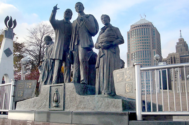
- Gateway to Freedom Monument at Hart Plaza on the Detroit Riverfront marks the crossing point of thousands of freedom seekers into Canada. Runaways referred to the Detroit River as their “River Jordan,” and Canada as their “Land of Canaan.” Sculpture created by Ed Dwight.
- Second Baptist Church served as a safe house for freedom seekers and a meeting place for abolitionists and UGRR operatives in Detroit and Canada.
- Frederick Douglass – John Brown Meeting Marker. Downtown Detroit at E. Congress and St. Antoine St. Eight months before the Harper’s Ferry raid, Frederick Douglass and John Brown met with several Detroit residents at the home of abolitionist William Webb on March 12, 1859, to discuss methods for ending slavery in America; while Douglass sought an end to slavery through political means, Brown believed revolution was the way to end the system; on December 2, 1859 Brown would die for his beliefs after the famed Harper’s Ferry Raid in West Virginia.
- George DeBaptiste Marker at E. Larned St. and Beaubien St. recognizes George DeBaptiste as a long-time Mason and one of Detroit’s most active and impassioned African-American community leaders. He lived on this site during the 1850s and 60s. He owned the ship “T. Whitney” that transported runaways across the Detroit River to freedom in Canada. It would stop in Amherstburg, Ontario on the pretense of getting lumber, while actually shuttling fugitive slaves to freedom. A white man, Captain Atwood, a proven abolitionist (he became involved in the Underground Railroad and was forced to leave Madison, IN because of his anti-slavery activities), was hired by DeBaptiste to run the boat, since African Americans were not allowed to run steamboats at the time. DeBaptiste became the personal valet of General William Henry Harrison, whom he accompanied to the White House as a steward.
- William Lambert Home Marker at the northeast corner of E. Larned St. and St. Aubin St. A black leader in Michigan, Lambert was active in the antislavery movement and served as the head of the Detroit Vigilance Committee. In 1843 he helped organize the first State Convention of Colored Citizens and served as its chairman. He was one of those present at the meeting between John Brown and Frederick Douglass at the home of William Webb where he made a financial contribution to the Harpers Ferry Raid led by John Brown in 1859.
- Elmwood Cemetery offers a brochure at the visitor’s center listing burial sites of the most famous and influential African Americans of the 19th century including abolitionists George DeBaptiste, Dr. Joseph Ferguson, and William Lambert, as well as Civil war veterans from the 1st Michigan Colored Infantry.
The following sites are within a day’s bike ride from the Detroit Alternate route in Michigan.
- Nankin Mills*, 33175 Ann Arbor Trail, Westland, MI. For a time the Underground Railroad followed along the Lower and Middle Rouge River, through what was then Nankin Township.
- Greenmead Historical Park*, 20501 Newburgh Rd, Livonia, MI. This 95-acre park was the 1820’s homestead of Michigan pioneer Joshua Simmons, and includes the original farm complex, historical village, picnic facilities and recreational areas. Together, the buildings tell the story of farm life in rural Michigan. The Simmons family were related to the abolitionist Power family of Farmington.
- Philbrick Tavern*, West 11 Mile Rd. at Power Rd. in Farmington Hills. In the 1830’s and 40’s the home was a tavern operated by Nathan Philbrick and was one of the finer hostels in southern Oakland County and also served as a meeting place for the early Township government. In the 1850’s, according to a strong and persistent local legend, the place served as a station on the Underground Railroad.
- Freedom Acres – Wilson Home*, West 11 Mile Rd., between Middle Rd. and Orchard Lake Rd. in Farmington Hills. Ellen Wilson was born a slave and in 1850, she and her husband, Aaron, came to Michigan, and then went on to Canada and remained there for three years, obtaining Canadian citizenship and, as a result, their freedom. The two returned to Farmington.
- James B. Wells Farm*, Sections 12 and 14 of Franklin Township. The Wells Farm was a station on the Underground Railroad.
- Emmendorfer House*, 4121 Pontiac Trail in Orchard Lake. An 1830’s house built by William Gilmour contains two hidden chambers, one accessible only through a small opening hidden behind built-in drawers in a bedroom; the other, through the rear of a closet. The house was in a strategic location on the Pontiac Trail, one of the few early roads in Oakland County, halfway between Farmington and Pontiac.
- Waterford Mill*, 16580 Northville Rd. in Northville. This 1800’s grist mill harbored runaway slaves and gave them employment through the efforts of mill owner and abolitionist, Samuel Pettibone Mead. Robert Wallace one of the runaway slaves jumped from the mill after it was suspiciously set on fire in 1850. He settled in the Village of Waterford (now Northville) and became the first black Wesleyan Methodist Minister. You can find Mead’s final resting place at the Waterford Village Cemetery 16170 Franklin Rd., Northville, MI. It is the first integrated cemetery for its time. It is also part of the extinct Village of Waterford that sent the largest contingent of volunteers to the Civil War in the State of Michigan.
- Spring Hill Farm* at the end of Hamlin Rd. in Utica. This is the location of the “Beacon Tree,” which was planted in 1850 by the Lerich family and neighbors. Fugitive slaves were told to look for it 24 miles north of Detroit City Hall and twelve miles east of Pontiac Courthouse in Macomb County. The Lerichs fed, clothed, and housed the runaways and devised a way for fugitives to slide down to the spring in order throw dogs off the freedom seeker’s tracks. The Lerichs also ferried fugitives along the Underground Railroad in the family wagon, hidden between bags of hay. They had many visits from Sojourner Truth, Frederick Douglass, and Peter Jaxson.
- The Malinda Robinson Paris Story* (PDF), St. Clair County. Born in Kentucky to a free black woman and a slave father, Malinda’s mother finally had to flee north to avoid enslavement of her children, leaving her husband behind. Malinda married William Paris when she was 18 years old, and the couple eventually moved to Canada, then to Detroit. William had escaped to Canada through the Underground Railroad; he was born free and had been captured and put into slavery several times before the move to Canada. Malinda lived the reminder of her life in St. Clair, Michigan.
* Denotes a site not listed on the map.
UGRR Detroit Alternate Highlights – Section 2: Sombra, ON to Owen Sound, ON
Amherstburg, ON
- North American Black Historical Museum is a complex that includes a cultural center and historic structures. The museum protects, preserves, and proudly presents rich Black heritage with special focus on the Underground Railroad. Connected to the Museum is the Taylor Log Cabin, a historic residence and the Nazrey African Methodist Episcopal Church stands next door. Many slaves and oppressed Blacks came by way of the Detroit River into Amherstburg since it was the narrowest point to cross the Detroit River. The museum tells the story of the refugees, many of whom swam across the river with their few belongings tie to their backs.
Windsor, ON
- Sandwich First Baptist Church is one of the oldest Canadian Black Baptist churches that was active during the UGRR era. In the early 19th century, Sandwich was a popular destination for refugees fleeing across the Detroit River. The congregation was established in 1840 and by 1851 the community was able to raise this fine brick chapel that continues to serve the community today. Many of the bricks that built the church were made by slaves escaping through the UGRR as payment for a meal and safe haven that had been provided by a member of the congregation.
- Tower of Freedom Underground Railroad Monument is located at 200 Pitt St. E., near River Front Dr. This sculpture illustrates the refugees’ arrival into Canada and their overwhelming emotion upon encountering freedom. The twenty-two foot high granite “Freedom Tower” serves as a candle representing the “Internal Flame of Freedom.” The Canadian side of the sculpture depicts a male slave giving thanks and a female slave holding a baby with a female Canadian Underground Railroad “operative” welcoming them to safety. On the U.S. side of the tower is a small slave girl looking back toward America and the Gateway to Freedom Monument at Hart Plaza on the Detroit Riverfront. The “Freedome Tower” monument also honors the City of Windsor and the Province of Ontario as a point of willing embarkation for safe refuge for thousands of slaves.
- John Freeman Walls Historic Site and Underground Railroad Museum* is barely off route at 859 Puce Rd. John Walls was an escaped slave who traveled from North Carolina to Canada. In 1976 Walls’ descendants worked to have this site recognized for its historical significance. Through re-enactments, guides bring to life the journey and dangers that slaves faced when escaping from slavery into freedom in Canada.
Puce, ON
- Puce River Black Community Provincial Plaque at the B.M.E. Cemetery on Division Rd. The black community in Puce River is tied to the Refugee Home Society, an abolitionist organization founded in the early 1850s. The society gave former slaves the opportunity to purchase 25-acre farms in Sandwich and Maidstone, helping over 60 black families. The Society also set aside a portion of lands in the area for the construction of schools and churches. An AME Church and a BME Church and Cemetery were established in 1872. The BME church was replaced by First Baptist Church (see the plaque) at 710 Puce Rd. in 1964.
Buxton, ON
- Buxton National Historic Site and Museum in North Buxton is a former abolitionist-based town. Today its population consists of descendants and some of the original families. The Museum was built by descendants and serves as a tribute to this area.
- St. Andrew’s Church in South Buxton was built in 1858. Buxton was founded in 1849 by fifteen former slaves who arrived with Rev. William King. He and the Elgin Association purchased a plot of land for a planned refugee settlement called the Elgin Settlement and at its heart was the Buxton Mission. This church has the Buxton Liberty bell, which originally was rung every time a freed slave reached South Buxton. South Buxton became the largest settlement by the end of the Underground Railroad era.
Chatham, ON
- First Baptist Church Chatham. American abolitionist John Brown held the last of a series of clandestine meetings here to plan his “slave rebellion.”
- Chatham Kent Black Historical Society. A self-guided exhibit contains numerous attractions, including artifacts, audio-interactive life-sized figures of three prominent Black residents of early Chatham, and an audio/visual presentation. African Americans came to Canada in increasing numbers after the Fugitive Slave law of 1850. Some settled in Chatham. Once such prominent resident was Mary Ann Shadd Cary, a teacher, anti-slavery crusader, who started the Provincial Freeman newspaper in 1851. She was the first Black women to own and operate a newspaper.
Dresden, ON
- Uncle Tom’s Cabin Historic Site/Josiah Henson House. This site comprises the home of Reverend Josiah Henson and contains the world-class exhibit “I’ll Use My Freedom Well,” period buildings, and an interpretive center that houses 19th century artifacts and rare books highlighting North American Black history. Rev. Henson, a fugitive slave who found freedom in Ontario in 1830 via the Underground Railroad, established the Dawn settlement in 1841, a place where other freedom seekers learned to be self-sufficient and successful community members. Here you can see the settlement’s original buildings, including one of the oldest fugitive slave structures in Canada. Henson’s experiences were the reference for the title character in Harriet Beecher Stowe’s renowned novel, Uncle Tom’s Cabin.
Lucan, ON
- Wilberforce Settlement Plaque, 179 Main St., at the post office. In 1829 a group of fugitive slaves in Cincinnati decided to seek more secure refuge in Canada. In 1830 they purchased 800 acres of land in this vicinity with the help of Quakers in Oberlin, Ohio. It was named after the great British abolitionist William Wilberforce.
Owen Sound, ON
- Grey Roots Museum and Archives. The museum provides a living link to the past’s legacies, artifacts, and stories. See the exhibit from “Slavery to Freedom, African Canadians in Grey County.”
- UGRR Black History Cairn, 75 2nd Ave. E., Harrison Park. A monument to the city’s first black settlers, escaped slaves who followed the Underground Railroad to its most northerly terminus in Owen Sound.
- BME Church, 241 11 St. W. Established in 1856, the BME Church served the needs of former slaves arriving on the Underground Railroad and its parishioners are considered the founders of the Annual Emancipation Day Celebration.
More Route Resources
- How to Travel with your Bike on Amtrak
- No-Turn-Away Bike Camping Policies (Michigan)
- Back Roads and Beaches Route to Oberlin (Ohio)
- North Coast Inland Trail (Ohio)
- University Trail (Ohio)
- Kiwanis Trail (Michigan)
- Walpole Algonac Ferry (St. Clair River crossing between Michigan and Ontario)
- Lake Erie ferry (lake crossing between Ohio and Ontario)
- Cedar Point Amusement Park (Ohio)
- Canadian/U.S. border crossing information
- Connect and share photos with other riders on Instagram: #acaUGRRDetAlt
Roots of the Underground Railroad Route
The project was born in 2004 when Adventure Cycling began a partnership with the Center for Health Equity at the University of Pittsburgh to further encourage people from all walks of life and cultural backgrounds to explore America’s landscapes and history by bicycle. Combined with the nation’s burgeoning health crisis, Adventure Cycling and the Center for Health Equity saw a natural alliance with common goals.
Adventure Cycling contacted historians, preservationists, and researchers and asked: “How do you pick a single route that represents thousands of escape routes?”
During this period of slavery, the tribal custom of creating songs to transmit information was used to communicate between slaves from plantation to plantation. Adventure Cycling chose to map the first part of the route guided by the song, “Follow the Drinking Gourd.” This song refers to following the North Star and waterways to the Ohio River — in essence, it describes an escape route from Alabama and Mississippi. Upon reaching the Ohio River, Adventure Cycling relied on the knowledge and efforts of members and outside experts to steer the route to rich historic destinations while maintaining Adventure Cycling’s standards of great cycling roads and paths.
Successfully meeting the goals of the Underground Railroad Bicycle Route continues to depend upon the contribution of volunteers, members, Underground Railroad enthusiasts, historians, health advocates and more.
Core Planning Team
Mario Browne, MPH, CHES; Chuck Harmon; Anthony Ratajczak; Todd Scott; Stephen Thomas PhD
Advisory Board, Detroit Alternate
Barb Bickel, executive director, Visit Lorain County; Nancy Darga, managing director, MotorCities National Heritage Area; Deborah Johnson, clinical therapist; Joe Levin, board member, Michigan Trails and Greenways Alliance; Carol E. Mull, author of The Underground Railroad in Michigan; Joseph D.R. Tanner, administrative generalist and educational outreach specialist, The Hub of Detroit; Kimberly L. Simmons, founding president and executive director, Quarlls Watkins Heritage Project; Leslie C. Strong Williams, president, Fred Hart Williams Genealogical Society; Kathryn Underwood, city planner, Detroit Planning Commission.
Updates to Recently Released Maps
If you are planning a bike tour, be sure to get the most recent map updates and corrections for your route by selecting the route, and the appropriate section(s), from the drop-down menu below.
Over time maps become less useful because things change. Every year Adventure Cycling’s Routes and Mapping Department create map updates and corrections for every map in the Adventure Cycling Route Network, which now totals 52,047 miles. With the help of touring cyclists like you, we receive updates on routing, services, camping, and contact information. Until we can reprint the map with the new information, we verify the suggested changes and publish corrections and updates here on our website.
PLEASE NOTE: Covid has been particularly hard on the small businesses along our routes. While we do our best to keep the maps and these online updates current, you may encounter more closed businesses and longer stretches with limited or no services.
Refer to these updates for the most current information we have and submit reports of changes to the Route Feedback Form for the cyclists coming after you.
NOTE: Map updates and corrections only pertain to long term changes and updates. For short term road closures, please see the Adventure Cycling’s Routes Temporary Road Closures discussion in our Forums.