Map Features
Online Map Updates and Corrections
Adventure Cycling’s online map updates and corrections provides the most recent map updates. Be sure to check the online updates and corrections before you depart on your bike tour.
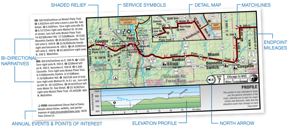
Service Symbols
Symbols correspond with the service information on the text side of the map, and tell bicyclists what sort of services they will encounter along the route such as campgrounds, bike shops, grocery stores, libraries, restaurants, post offices, hostels, motels, cyclists-only lodging, bed and breakfasts, and hotels.
Bi-directional Narratives
Narratives have detailed turn-by-turn instructions for traveling in either direction. The number preceding each directive indicates the distance you’ve come since the beginning of the map panel at the matchline. (The number following in parentheses is the distance in kilometers.) Changes in road names and numbers are marked by stars both in the narrative and on the map panel.
Elevation Profiles
Elevation profiles indicate major ascents and descents. On the Lewis & Clark Trail maps, the profile is attached to each map panel. On other maps, in the mountainous regions of the country, the profile appears in one continuous panel on the text side of the map. (Note: Not all map sections have elevation profiles.)
Scale
The scale on our maps is 1:250,000, with the exception of the Great Divide Mountain Bike Route, which is 1:200,000. In congested areas or areas that need it, all routes have larger-scale detail maps.
Contour Lines
Provide a general idea of elevation gains and losses.
North Arrow
 The north arrow is not necessarily up as it is on most maps, and it changes orientation from panel to panel. This allows as many miles of the route as possible to be depicted on each map panel, which helps us keep down map production costs.
For example, on the left, we have two index maps for section 4 of the Atlantic Coast Route. The one on the left (Figure 1) shows the map panels as they exist. In the other (Figure 2), panels are drawn so that all are oriented to the north (and still fit into a handlebar bag window). The 373 miles between Richmond, Virginia, and Wilmington, North Carolina, that we now cover in 12 map panels would require 19 map panels. In addition, the 248-mile Outer Banks Alternate, which we squeeze into four, double-map panels, would require 10 map panels! On north/south routes, it is evident that we would have to double the number of map panels we currently need to do a route. This would double production costs and make the maps more expensive.
Matchlines
Matchlines are solid pink lines on each end of the map panel intersecting the route. The narrative leads you from matchline to matchline. Once you "reach" the matchline, turn to the next map panel and begin following its narrative, again proceeding from the near matchline to the far matchline.
Distances
Narrative cue distances given in miles and kilometers. Point to Point distances between karats given in miles.
End Mileages
The mileage to either end of the route section is shown at the border of each map panel.
Field Notes
Details about the natural history and cultural heritage along the route
Annual Events and Points of Interest
For your information, selected museums, points of interest, and events are included, where space allows, on the map panels. Museums have a brief description of their exhibits. Annual events have a brief description and the time of year they occur.
Weather Chart
Provides average monthly precipitation and mean temperatures at various points along the route
Detail Maps
Provide large scale view of urban or congested areas
Riding Conditions
Summary information regarding road surfaces, traffic volumes, and areas of caution.
How to Read Our Maps
This short informative video gives a quick introduction to reading our maps, which are designed specifically with bicycle travelers in mind.