Eastern Express Connector

Eastern Express Connector Walden, CO to Indianapolis, IN 2 Map Set GPX Data | Overview | Buy | Mobile App
1. Walden, CO to Atchison, KS Detail
2. Atchison, KS to Indianapolis, IN Detail

The Eastern Express Connector is DIGITAL-ONLY. No paper maps are produced for this route. More info here: Going Digital: App or GPX.

A speedier version of the classic TransAmerica.

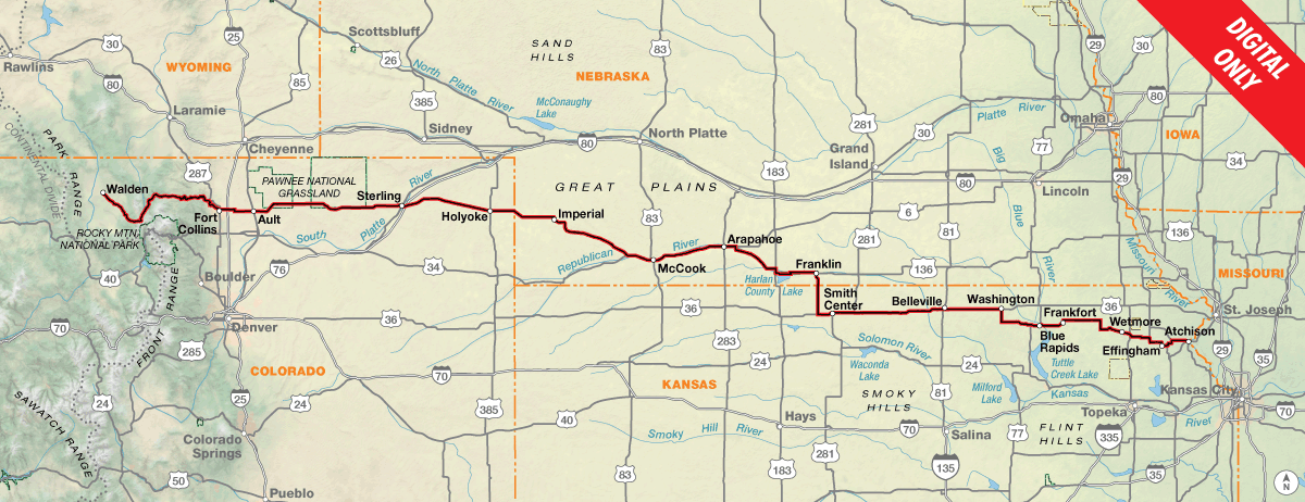
The Eastern Express Connector links the TransAmerica Trail in Walden, Colorado to the Chicago to New York City Bicycle Route in Indianapolis, Indiana. Originally created by veteran Adventure Cycling tour leader Frank Moritz, this variation of the classic TransAmerica Trail was designed to be a quicker (and easier) coast-to-coast experience for the time-constrained cyclist. Combined with the Chicago to New York City Route in the east, this route bypasses the most strenuous climbing in the Southern Rockies, Ozarks, and Appalachians, with the added benefit of avoiding the troublesome dog regions on the existing TransAmerica Trail.

Heading eastbound from Walden, the Eastern Express Connector crosses the Southern Rocky Mountains only once in Colorado at Cameron Pass, compared to the three high elevation passes on the traditional route. The route then descends the scenic Poudre River canyon into the bicycle-friendly college town of Fort Collins, the last significant population until you reach the St. Louis metro area in Missouri. Things start to dry out as you get into the eastern part of Colorado and cross into the southwestern corner of Nebraska. Carrying extra water is a good idea here – this is hot, barren country and services are limited. You might even have to do some early morning and early evening riding to escape the heat of the midday sun. Thankfully, many of the small towns along the way have public swimming pools, so pack your swimsuit!

The route through Kansas continues to be rural in nature, with not a single town’s population over 2,000 until Atchison. Near Lebanon, you’ll have the unique opportunity to visit the Geographic Center of the Contiguous U.S., as determined by a 1918 survey.

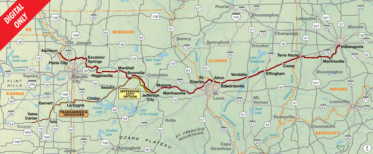
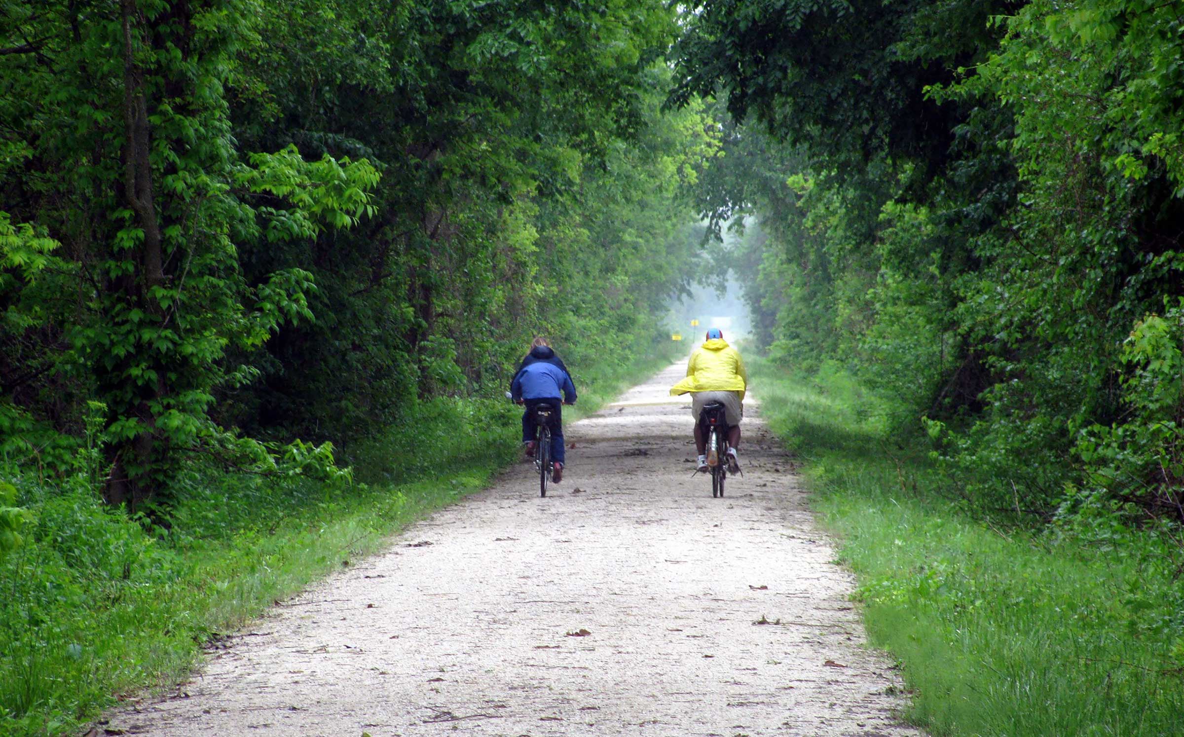
A highlight of the Connector is the historic Katy Trail, the country’s longest recreational rail trail. Now a state park, the crushed-limestone trail is built on the former corridor of the Missouri-Kansas-Texas Railroad and winds alongside the mighty Missouri River. The trail skirts the northern edge of the Ozark Mountains, avoiding the notorious climbing further south on the TransAmerica Trail, but the low-lying trail floods often due to its proximity to the river. Check for trail conditions and be prepared for detours if necessary. The Jefferson City Option can be used if the western portion of the Katy Trail is flooded.

In Boonville, Missouri, the “TransAmerica Crossover”, an alternate included with the Eastern Express Connector Route, provides a mid-way connection to the traditional TransAmerica Trail. Using a combination of the Katy and Prairie Spirit Trails, it links up with Section 8 of the TransAm just north of Toronto, Kansas. For cyclists who also plan to ride the Western Express, this Crossover creates a more streamlined route across Middle America.

After crossing the Mississippi River on the bike-friendly Clark Bridge, the Eastern Express Connector beelines across Illinois to the college town of Terre Haute, Indiana, a nice spot for a layover if you have the time. Don’t miss the roadside attraction town of Casey, Illinois, home to the world’s largest rocking chair, mailbox, pitchfork, and more.

The Connector finally terminates in Indianapolis, the state capital and largest city in Indiana. From here, ride onto the Chicago to New York City Bicycle Route to continue east on your “express” cross-country journey. In Pittsburgh, split off onto the Philadelphia Alternate which uses a combination of the historic Great Allegheny Passage (GAP) rail-trail and the C&O Canal Towpath trail to gently slice through the rugged Appalachian Mountains, in great contrast to the severe rollercoaster climbs you would instead encounter in eastern Kentucky and western Virginia on the classic TransAmerica Trail.

CC Image courtesy of joneser005 on Flickr

Western Colorado is high elevation, and you may notice shortness of breath if not accustomed to the altitude. The climb up to Cameron Pass (elev. 10,276 ft.) is long, but gradual and gently graded. The descent into Fort Collins is, of course, a blast with almost 60 miles of continuous downhill.

The ride across the Great Plains is gloriously flat, although brutal wind may take away any enjoyment gained from the lack of topography.

There are some gentle rollers in eastern Kansas, but the hills really begin in earnest in western Missouri. Climbing is different here than in the Rockies; the grades are short, steep, and numerous.

The Katy Trail provides relief from the constant Missouri hills. The trail is built atop an old railroad bed along the Missouri River, and is almost completely flat.

The terrain through Illinois and Indiana is defined by mellow ups and downs typical of the Midwest, with only a handful of notable climbs.

Eastern Express Connector - Main Route
Section Distance Elevation Total Climb Avg. Climb/mile
Total 1337.4 miles Minimum: 400 ft.
Maximum:10,275 ft.
26,960 ft. east bound
34,485 ft. west bound
20 ft. per mi. east bound
26 ft. per mi. west bound
1 700.1 miles Minimum: 820 ft.
Maximum:10,275 ft.
8,220 ft. east bound
15505 ft. west bound
12 ft. per mi. east bound
22 ft. per mi. west bound
2 637.3 miles Minimum: 400 ft.
Maximum:1160 ft.
18,740 ft. east bound
18,980 ft. west bound
29 ft. per mi. east bound
30 ft. per mi. west bound
Eastern Express Connector Alternates
Name Section Distance Total Climb Avg. Climb/mile
Jefferson City Option 2 54.5 miles 3,275 ft. east bound
3,350 ft. west bound
60 ft. per mi. east bound
61 ft. per mi. west bound
TransAmerica Crossover 2 227.2 miles 6,675 ft. north bound
6,960 ft. north bound
29 ft. per mi. north bound
31 ft. per mi. north bound

This route is primarily intended as a connector between the TransAmerica Trail and Chicago to New York City routes, collectively acting as a shortcut to the east coast by avoiding the Southern Rockies, Ozarks, and Appalachians. If you also intend on riding the Western Express Route, use the TransAmerica Crossover for a more direct course to/from Pueblo, Colorado.

With the exception of Fort Collins, Section 1 of this route is rural and dotted with small towns at 20–40-mile intervals, although services in some of these towns are limited or non-existent. There are no bike shops on route between Fort Collins and Atchison, and the bike shop in Atchison is limited. Services become more frequent on Section 2.

The Katy Trail in Missouri commonly floods during high-water events. Even if the trail is not currently underwater, damage from a recent flood may force some sections to remain closed. The Jefferson City Option can be used if any portion of the Katy Trail from Boonville to Jefferson City is closed. If the eastern portion of the Katy Trail is flooded, you’ll have to get creative with a detour of your own.

Some campgrounds will charge a cyclist traveling alone less if they have hiker/biker sites, but often they will charge the price of a regular tent site, and that can easily be $10-$20/night. If you’re friendly and ask around, you can often get yourself invited to camp in a yard. In national forests you are allowed to camp anywhere on national forest land as long as you “pack it in, pack it out.” Many city parks are free to camp in.

Missouri State Parks have a no-turn-away policy which can be found at advcy.link/noturnaway.

This route can be ridden from May through September. Note that snow can occur at any time in the Rocky Mountains, and Cameron Pass in Colorado is over 10,000 feet in elevation. Although the prevailing weather patterns are overall from west to east, local wind patterns are more dependent on the passing pressure systems and local terrain, so you can expect your fair share of tailwinds, crosswinds, and headwinds regardless of which direction you ride the route.

You may also wish to sign up with Warmshowers, a reciprocal hospitality site for bicycle travelers, for other overnight options.

Eastern Express Connector Highlights

  • Cameron Pass and Poudre River Canyon, Section 1
  • Fort Collins, Section 1
  • Pawnee National Grasslands, Section 1
  • Enders Reservoir State Recreation Area, Section 1
  • Home on the Range Cabin, Section 1
  • Geographic center of the US, Section 1
  • Amelia Earhart Birthplace Museum, Section 1 & 2
  • Lewis & Clark State Park, Section 2
  • Weston Bend State Park, Section 2
  • Watkins Mill State Park, Section 2
  • Arrow Rock Historic District, Section 2
  • Katy Trail, Section 2
  • Prairie Spirit Trail, Section 2, TransAmerica Crossover
  • St. Charles Historic Main Street, Section 2
  • Nickel Plate Trail, Section 2
  • World’s Largest Items in Casey, IL, Section 2
  • National Road Heritage Trail (Terre Haute segment), Section 2
  • Lieber State Recreation Area, Section 2

More Route Resources


RIDING CONDITIONS

The Eastern Express Connector begins at an intersection with Section 6 of the TransAmerica Trail in Walden, Colorado. SR 14 through the North Park Valley is shoulderless, but traffic is minimal and the sightlines are long. Shoulders appear near the summit of Cameron Pass (elev. 10,276 ft.) and stick around for about 23 miles before disappearing again at the Poudre River Fish Hatchery. Traffic picks up on the east side of the pass, especially on weekends in the summer and fall. SR 14 through the scenic Poudre River Canyon east of Rustic is narrow and winding. Services are limited between Walden and Fort Collins, but campgrounds are plentiful.

Fort Collins is a great place for a layover day. It’s a college town (Colorado State University), a platinum rated bike-friendly city, and has over a dozen bike shops. Whether headed eastbound or westbound, be sure to stock up on a good supply of groceries here; it’s sporadic convenience stores-only for the next 100 miles in either direction. It’s also your last chance to visit a real bike shop for the next several hundred miles, so make sure your bike is in good shape and you have any necessary tools and spare parts you may need.

The route uses the Poudre Trail to access downtown Fort Collins. See advcy.link/FCbikemap for a complete bicycle map of Fort Collins. NOTE: Riding a bike on the city’s main commercial street (College Ave./US 287 south of the downtown area) is prohibited, and it’s unsafe and unpleasant anyway.

The route east of Briggsdale is a long, gradual decline into the Platte River Valley, as you traverse some of eastern Colorado’s “outback”. If you like wide-open spaces and a horizon that goes on forever, this is your ride. The route travels through the Pawnee National Grasslands, an area of the Great Plains that saw limited cultivation in the early 20th century. As a result, the area is very sparsely populated and services are limited and unreliable. Carry extra water and call ahead to confirm operating hours if you are depending on a service to be open. Many services are closed on Sundays.

The traffic on SR 14 in eastern Colorado can be heavier than you might expect on weekdays, and it moves fast and can include a lot of trucks. The shoulders are mostly good, except between Ault and Briggsdale where they narrow, especially in the westbound direction.

As you enter the town of Sterling, make sure to follow the route’s diversion onto Platte Street, two blocks north of Main Street/SR 14. This is the safest route through town, and it avoids a 1.5-mile gauntlet of fast-food restaurants and big-box stores along 4-lane Main Street.

After a gentle climb out of the Platte River Valley, you’ll begin the long, imperceptible descent across the Great Plains. Shoulders are good on US 6 in Colorado and between Imperial and Enders in Nebraska. Otherwise, the shoulders on US 6 are narrow to nonexistent with occasional rumble strips on the white line. Traffic is light and services are few and far between. Make sure to change your clock when you cross the time zone border at the Chase/Hayes county line.

Because of scorching summer temperatures, you may be tempted to ride in the early morning and/or late evening. However, be aware that you’ll be riding into the rising or setting sun, depending on your direction of travel, which will blind you and motorists coming up behind you. Turn on your taillights and wear high-visibility clothing.

At Culbertson you’ll join US 34 and begin a multi-day ride through the broad Republican River Valley. The shoulders are wide, but the traffic is heavier as small towns become more frequent along the river. US 6/34 (B Street) through McCook is a busy 4-lane road. Although it has many of the town’s services, it is not the recommended cycling route. Use C Street instead, one block to the north. US 136 east of Edison has no shoulders, but less traffic than US 34.

At Franklin, you’ll turn south leaving the Republican River Valley to enter Kansas. The remainder of Kansas is rural (until Atchison), with towns a little smaller and spaced a little farther apart than in Nebraska. For an interesting side-trip, head off route to visit the Geographical Center of the Contiguous United States in Lebanon.

As you ride east across Kansas, you’ll start to notice a change in your surroundings. Gentle hills rise from the landscape, and the route is a continuous stream of rollers as it cuts across many small drainages. Shoulders widths on US 36 vary and traffic is moderate. SR 9 has narrow to nonexistent shoulders but traffic is mostly light. Watch out for “Texas tacks,” aka goatheads or puncturevine, a thorny weed that is the scourge of bicycle tires.

Section 1 ends at the Missouri River in Atchison, the first town with a population above 10,000 since Sterling, Colorado. A quaint town with sufficient services, it’s the perfect spot for a rest day before continuing your adventure. Speaking of adventures, Atchison is the hometown of Amelia Earhart, the first female aviator to fly solo across the Atlantic Ocean. You can visit her childhood home downtown and the new Amelia Earhart Hanger Museum (opening in 2023) located at the Amelia Earhart Memorial Airport.

Be aware that camping in city parks may have some drawbacks if you’re traveling early in the year. Many towns that have showers and restrooms, which are connected to the town swimming pool, often don’t open until after Memorial Day, so water and restrooms won’t be available.

NOTE: Many of the smaller towns on this section have a limited grocery supply. Plan and stock up when you pass through larger towns.

All known Amtrak stations are listed on this map but not all stations provide bicycle service. Check if bicycle service is provided at both the starting and ending stations on your trip using the spreadsheet and other trip planning resources at advcy.link/amtrak.

CLIMATE

The mountain ranges in Colorado can have very cold overnight temperatures, so expect to wear several layers at night even if the days are warm. Also be prepared for the possibly of snow at higher elevations, which can fall as late as June and as early as September.

The wind blows almost constantly on the plains, and it can whip up huge clouds of dust, particularly on the high plains of Colorado. These storms sting the face, cause the eyes to water, and reduce visibility to no more than several feet. Cyclists are advised to stay off the road during such storms. Severe late-afternoon thunderstorms (and the occasional tornado) are common in eastern Colorado, Nebraska, and Kansas from mid-July through mid-September. A tornado’s path of travel can be erratic. If you see one on the horizon, seek shelter below ground at a farmhouse if possible. If not, find a ditch or low spot and wait out the storm.

To a cyclist riding west to east, the elevation is dropping, albeit slowly and irregularly. With this loss in elevation comes a change in the humidity and temperature. The 100th meridian, which crosses the route near Holbrook, Nebraska, is usually regarded as the dividing line between the semiarid high plains and the semi-humid lowlands to the east. West of the meridian, the average rainfall is 5-20 inches; east of it, average annual rainfall jumps to 20-25 inches, a major portion of which falls during the summer growing season. This explains why the Colorado foothills and high plains are cattle country, while eastern and central Kansas are wheat and corn farmland. Much of the increased moisture coming into the area east of the 100th meridian is blown north from the Gulf of Mexico. Expect to have several days of riding with strong crosswinds.

Updated: Oct 5, 2022


RIDING CONDITIONS

Section 2 of the Eastern Express Connector begins in Atchison, Kansas, and quickly crosses into Missouri on the wide-shouldered Amelia Earhart bridge over the Missouri River. The Connector route through most of Missouri is identical to the Lewis & Clark Bicycle Route, created to celebrate the anniversary of the Corp of Discovery’s 1804-1806 expedition from the mouth of the Missouri River to the Oregon coast.

The route is flat along the Missouri River floodplain until Weston, where you’ll leave the river and enter the pastoral Missouri countryside. Traffic on the state secondary roads (designated with letters) is mostly light, but the roads are hillier than you might expect. Prepare yourself for an endless rollercoaster ride with some steep, albeit short, ascents and descents. Also pay attention to street signs and freshen up your navigational skills; there are lots of turns between Weston and Excelsior Springs.

South of Excelsior Springs you’ll drop down into the Missouri River floodplain again for a nice break from the constant hills. SR 210 has more traffic but nice, wide shoulders. At Henrietta the route turns south onto SR 13, a divided 4-lane limited access highway across the Missouri River. Traffic can be high, but the shoulders are wide in both directions.

The hills return between Lexington and Boonville, Missouri. SR 20 has wide shoulders, but they are unpaved. SR 41 between Marshall and Boonville is mostly shoulderless. The touristy village of Arrow Rock, a National Historic Landmark, is a nice spot to spend the night or an afternoon. Make reservations in advance, this area is popular with visitors in the summer.

From Boonville eastward, the route uses 169 miles of the Katy Trail (advcy.link/katytrailsp). This converted railroad bed is composed of crushed lime­stone and skirts the north bank of the Missouri River. Consequently, the Katy Trail and adjacent road­ways are prone to flooding during late spring/early summer. Even if the trail is not currently underwater, damage from a recent flood may force some sections to remain closed. The Jefferson City Option (54.6 miles) can be used if any portion of the Katy Trail from Boonville to Jefferson City is closed, or if you just prefer riding on pavement. This Option is four miles longer than the Main Route.

Towns along the Katy Trail are small with limited services, so you might have to go off route to resupply or spend the night. The towns of Jefferson City, Hermann, and Washington across the Missouri River are all accessed by newer bridges with dedicated pedestrian and bicycle paths.

Boonville is also the endpoint (or startpoint for westbound riders) of the TransAmerica Crossover, a connector to the more southerly TransAmerica Trail. The Crossover is ideal for anyone who also plans to ride the Western Express Route, which connects to the TransAmerica Trail in Pueblo, Colorado. It’s also the choice for those who are only riding the Eastern Express Connector to avoid the rollercoaster climbs of the Ozark and Appalachian Mountains, but don’t mind the long and steady grades in the Colorado Rockies on the original TransAm. The Crossover begins near Toronto, Kansas on Section 8 of the TransAmerica, and travels 227 miles into Missouri to meet the Eastern Express Connector in Boonville. From Iola to Garnett it follows 27.5 miles of the Prairie Spirit Trail (advcy.link/prairiespirittrl), a converted rail bed with a crushed limestone surface. Five miles of the route between Garnett and Parker are on unpaved roads. In Clinton, you’ll join the Katy Trail for the remaining 73.5 miles into Boonville.

NOTE: When traveling on the KATY in wet weather, your bike’s wheels will spray a mineral coating from the trail’s crushed limestone surface onto your frame and drivetrain, which will harden into a white film if you don’t clean your bike thoroughly at the end of the day’s ride.

St. Charles is an all-services town that’s contained within the St. Louis metropolitan area. The brick-lined Historic Main Street overlooks the river and is lined with 19th century buildings, lively restaurants, and charming boutiques. It’s worth a visit and is easily accessible via the Katy Trail.

The Katy Trail comes to an unceremonious end east of St. Charles on a narrow floodplain sandwiched between the Missouri and Mississippi rivers. The Clark Bridge across the Mississippi River into Illinois has bike lanes in both directions but watch out for debris and rumblestrips. For the next 28 miles, the route uses a combination of Madison County Transit’s (MCT) Confluence, Goshen, Watershed, and Nickel Plate Trails. See a map of MCT’s trails here: advcy.link/MCTtrails. The Confluence Trail travels atop a levee alongside the east bank of the Mississippi River. Although paved, portions of the trail are in poor condition due to repeated flooding events. Ride with caution. After a brief connection on surface streets past the sprawling Wood River Refinery, you’ll ride onto the paved Goshen and Watershed Trails into Edwardsville. From there, the unpaved Nickel Plate Trail takes you to Alhambra.

The route across Illinois is generally flat, with some rolling hills in and out of creek bottoms. SR 140 from Alhambra to Mulberry Grove has shoulders, but they are not paved. For the remainder of Illinois, with a few exceptions, the route makes a beeline northeast on US 40. US 40 parallels I-70, which carries most of the through-traffic, but US 40 still has a decent amount of local traffic between towns. Shoulder widths and surface type vary; for many miles the shoulders are wide but unpaved. Effingham is the largest town on this stretch, and has all services including a bike shop. Don’t miss the unique town of Casey, famous for being home to many of the “world’s largest” objects. Also, remember to change your clock when you cross the time zone at the Illinois/Indiana state line.

Because of scorching summer temperatures, you may be tempted to ride in the early morning and/or late evening. However, be aware that you’ll be riding into the rising or setting sun, depending on your direction of travel, which will blind you and motorists coming up behind you. Turn on your taillights and wear high-visibility clothing.

Terre Haute, home to Indiana State University, is a pleasant town to ride through and uses a portion of the paved National Road Heritage Trail (www.nrht.org).

You’ll probably be sick of corn fields by this point, but there’s still more to come. SR 42 cuts across rural farming country, with services at a minimum. East of Poland, you’ll get a break from the corn as the trees (and hills) return around Cagles Mill Lake. The campground at Leiber State Recreation Area, off route three miles to the north, is a wonderful spot for an overnight.

West of Martinsville, you’ll encounter the biggest hills since western Missouri, steep enough that you may have to walk your bike.

At Martinsville, the route turns north along USBR 235 (advcy.link/inusbr) to the Connector’s endpoint in Indianapolis. The last several miles into downtown use the Eagle Creek Trail (advcy.link/eaglecrtrl )and White River Wapahani Trail (advcy.link/whiterivertrl).

From Indianapolis, head east on Section 2 of the Chicago to New York City Bicycle Route to extend your tour toward the Atlantic. To maintain the ongoing theme of avoiding the mountains, deviate onto the Philadelphia Alternate when you reach Pittsburgh, Pennsylvania. This Alternate follows the Great Allegheny Passage (GAP)/C&O Canal Towpath trails to Williamsport, Maryland which gently slice though the notoriously steep Appalachian Mountains. From there, continue on the Philadelphia Alternate to the Atlantic coast in Mantoloking, New Jersey, or stay on the C&O Canal Towpath Trail to its end at the Potomac River in Washington D.C.

All known Amtrak stations are listed on this map but not all stations provide bicycle service. Check if bicycle service is provided at both the starting and ending stations on your trip using the spreadsheet and other trip planning resources at advcy.link/amtrak.

CLIMATE

The continental climate of Missouri is subject to frequent changes. The three primary causes of these changes are (1)cold air moves down from the north; (2)warm, moist air enters the southern portion of the state from the Gulf of Mexico; and (3)dry air from the plains sweeps into the western part of the state.

The wettest months along Section 2 of the route are May and June. Severe thunderstorms are common in the summer. Throughout this section, humidity is high enough to make riding uncomfortable on warm summer days.

Tornados are possible across Missouri, Illinois, and Indiana. Their path of travel can be erratic. If you see one on the horizon, seek shelter below ground at a farmhouse if possible. If not, find a ditch or low spot and wait out the storm. Peak tornado season is between April and June.

Updated: Oct 6, 2022

Updates to Recently Released Maps

If you are planning a bike tour, be sure to get the most recent map updates and corrections for your route by selecting the route, and the appropriate section(s), from the drop-down menu below.

Over time maps become less useful because things change. Every year Adventure Cycling’s Routes and Mapping Department create map updates and corrections for every map in the Adventure Cycling Route Network, which now totals 52,047 miles. With the help of touring cyclists like you, we receive updates on routing, services, camping, and contact information. Until we can reprint the map with the new information, we verify the suggested changes and publish corrections and updates here on our website.

PLEASE NOTE: Covid has been particularly hard on the small businesses along our routes. While we do our best to keep the maps and these online updates current, you may encounter more closed businesses and longer stretches with limited or no services.

Refer to these updates for the most current information we have and submit reports of changes to the Route Feedback Form for the cyclists coming after you.

NOTE: Map updates and corrections only pertain to long term changes and updates. For short term road closures, please see the Adventure Cycling’s Routes Temporary Road Closures discussion in our Forums.