Underground Railroad (UGRR)
Due to limited resources, the paper map version of this route has been discontinued. This route is still available digitally.
Route Options
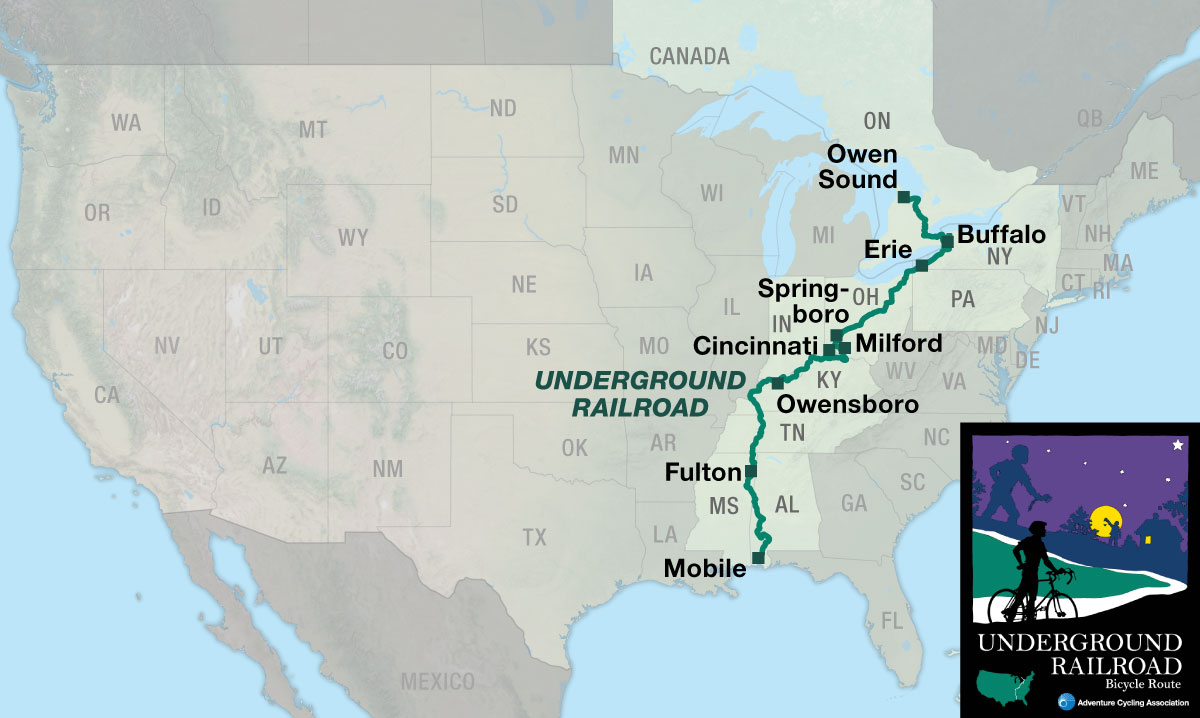
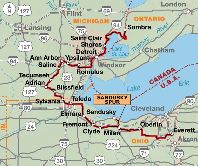
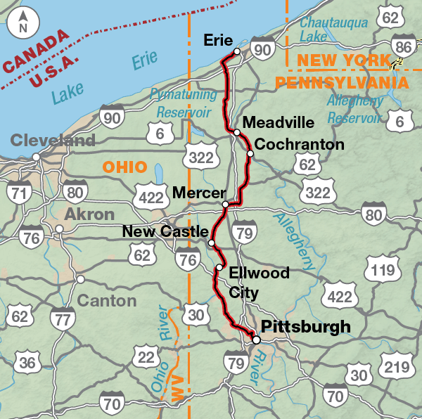
The Underground Railroad Bicycle Route (UGRR) memorializes the Underground Railroad, a network of clandestine routes by which African freedom seekers attempted to escape slavery before and during the Civil War. This page describes the 1,997.1-mile Underground Railroad Bicycle Route from Mobile, Alabama to Owen Sound, Ontario. You may also be interested in the UGRR Detroit Alternate, UGRR Pittsburgh Spur, or the day-trip rides in Ripley, Ohio (PDF).
Ride America’s legendary route to freedom.
The history of this remarkable period comes alive as you pedal along the 1,997.1-mile corridor that traces the Underground Railroad route from the Deep South to Canada, passing points of interest and historic sites. Beginning in Mobile, Alabama, — a busy port for slavery during the pre-civil war era — the route goes north following rivers through Alabama, Mississippi, Tennessee, and Kentucky. Waterways, as well as the North Star, were often used by freedom seekers as a guide in their journeys to escape slavery. Upon crossing into Ohio, the route leaves the river to head toward Lake Erie and enters Canada at the Peace Bridge in Buffalo, New York. In Ontario, the route follows the shores of Lake Ontario and ends at Owen Sound, a town founded by freedom seekers as early as 1843. Owen Sound is located on the southern side of Lake Huron’s Georgian Bay.
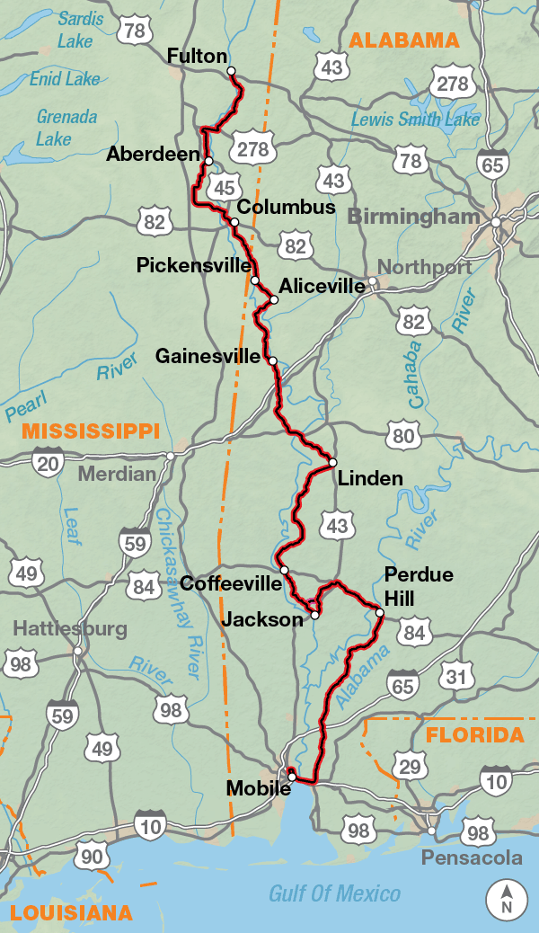
The southernmost map begins in historic Mobile, Alabama, and follows several river courses northward. In the 1800s Mobile was a key port for ships to unload enslaved Africans. The Tensaw, Alabama, and Tombigbee rivers all flow into Mobile Bay, and were used as guides for freedom seekers to escape northward. Besides the lush green scenery and the many small towns this route passes through, a host of museums, historic parks, and visitor centers bring the region’s history alive.
Historical road plaques are abundant, and riders can read about Indian massacres and the German prisoner-of-war camp in Aliceville, Alabama. One can camp at Historic Blakeley State Park where the last major battle of the Civil War was fought, occurring on the very day that General Lee surrendered in far-off Virginia. There are churches to visit while pedaling past town squares of courthouses and Confederate memorials, tall loblolly pines and the brown waters of the slow-moving Tombigbee and Tennessee rivers… it’s like pedaling through a William Faulkner novel.
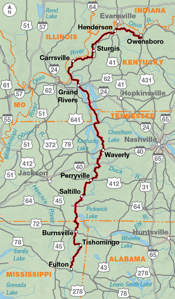
Just north of Fulton, Mississippi, the route joins the Natchez Trace Parkway for 10 miles. The area of western Tennessee and Kentucky is rich in American Indian and Civil War history. This area also has many short roller coaster hills. The Shiloh National Military Park and the Fort Donelson National Battlefield are both along the route. You’ll also follow “The Trace Road” through the Land Between the Lakes National Recreation Area, an expanse of woods where bison roam. No commercial vehicles are allowed on this road and a 45 m.p.h. speed limit is strictly enforced. Upon reaching the Ohio River, once known as the dividing line between the slave and free states, the route then heads northeast along the river.
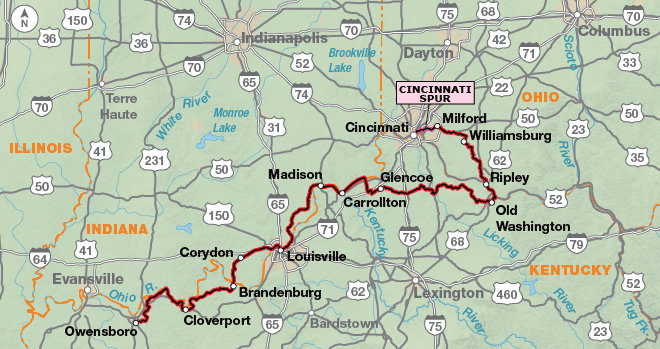
As you ride close to the Ohio River in the tri-state Kentucky/Indiana/Ohio region, you’re in the Borderland, a narrow strip of land lining both sides of the river that saw some of the Underground Railroad’s most intense activity, and where a concentration of physical evidence remaining from those days still exists. The towns of New Albany, Lancaster, and Madison in Indiana, and Augusta, Old Washington, and Maysville in Kentucky all have buildings, churches, homes or sites to visit. Roads are generally narrow and winding with low traffic counts. The route alternates between following the river and heading inland.
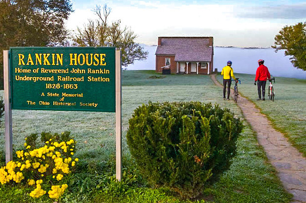
At Maysville you’ll cross the river into Ohio, and then ride downstream a few miles to Ripley, which comprises a fifty-five acre National Historic District. Among the numerous Underground Railroad conductors who were active in Ripley, John P. Parker and the Rev. John Rankin stand out. Parker, an iron worker and inventor, was a former slave who had purchased his freedom. As a conductor, he would often slip back into slave territory to help freedom seekers find their way from Kentucky to Ohio. Rankin, a Presbyterian minister, along with his large family, provided shelter to hundreds of runaways in their home located high above town on Liberty Hill. Of an estimated 2,000 freedom seekers that passed through Ripley, most stayed with the Rankins. Their house could be identified at night from the river by the candle glowing in its window.
There is a 16-mile spur into downtown Cincinnati. The city holds numerous sites relating directly to Blacks’ struggle for freedom, including the National Underground Railroad Freedom Center and the Harriet Beecher Stowe House. The National Underground Railroad Freedom Center is the premier facility in the country highlighting the heroics and tragedies associated with the Underground Railroad. Exhibits include the hauntingly evocative Slave Pen, a small log structure that was used to store as many as seventy-five enslaved people awaiting to be shipped to and sold in the Deep South. It was moved to the center from a farm in Mason County, Kentucky.
From Milford north to Xenia, you’ll cycle along a grade that beginning in the mid-1800s served an “overground” railroad. After the trains stopped running in the 1970s, the route was turned into a rail-trail for bicyclists and other non-motorized travelers. The trail parallels the Little Miami State and National Scenic River, creating the additional option of stashing your bike for a day and checking out the same scenery by canoe. (Rentals and shuttles are available at several area liveries.) One of the longest paved rail-trails in America, the Little Miami Scenic Trail offers fifty miles of the most enjoyable cycling you’ll experience on the UGRR. The delightfully car-free trail winds amid an ever-changing rural landscape of rolling farmlands, picturesque towns, river cliffs, and hardwood forests. A host of warblers and other songbirds provide background music befitting the bucolic surroundings, and you may also spot wildlife like whitetail deer, coyote, and beaver. This is just the beginning of the Ohio to Erie Trail, an amalgamation of primarily off-street recreational trails from the Ohio River to Lake Erie, which the route follows for much of its traverse across Ohio.
The rapidly growing community of Springboro is reached by taking the Springboro Spur from Waynesville. It’s a side trip you should not miss. Founded by anti-slavery Quaker Jonathan Wright in 1815, Springboro evolved into one of the most frequented stopovers for freedom seekers. It’s estimated that some 4,000 escaped slaves traveled through Springboro on their flights to freedom between 1815 and 1864. Today, the historic downtown district holds more documented Underground Railroad safe houses than any other community in the state, at least one of which you can overnight in: the 1815 home of town founder Wright, the oldest home in Springboro. Now known as the Wright House Bed & Breakfast, there you can view a hiding place squeezed between the second story and the attic, as well as inspect an impressive collection of antiques and artifacts from the period.
In Wilberforce, an unincorporated community just northeast of Xenia, you’ll find the National Afro-American Museum and Cultural Center. The museum’s mission is to inform and teach visitors about Black history and culture, beginning with the African origins and stretching to present times. One highlight is the museum’s small theater that regularly screens the award-winning Music As a Metaphor, a half-hour video tracking the origins and evolution of Black music from its African roots to the popular music of the 1950s.
The route travels through Ohio’s capital, Columbus, and temporarily deviates from the Ohio to Erie Trail to follow the Olentangy Trail through the city.
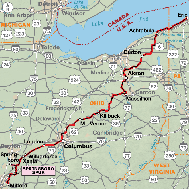
The route continues northeast on the Ohio to Erie Trail, passing through the small towns of Mt. Vernon, Millersburg, and Massillon. In Akron, the route navigates efficiently through the urban hub entirely on traffic-free bike paths. Learn about abolitionist John Brown, and see the house he lived in between the years of 1844 and 1854.
Ashtabula County occupies the extreme northeast corner of Ohio. Best known for its numerous wineries and beautiful covered bridges, the area held some three-dozen Underground Railroad safe houses. Here you’ll ride on the Western Reserve Greenway, a “linear park” following the former right-of-way of the PennCentral Railroad. A dozen Underground Railroad interpretive markers line the twenty-seven miles of the greenway (thirteen of which are part of our route) claimed by Ashtabula County, identifying such sites as the Hubbard House, which is situated adjacent to Walnut Beach in the city of Ashtabula. The safe house was considered a northern terminus of the railroad, as escaped formerly enslaved people would go from there by boat across Lake Erie to Canada. It’s now home to an Underground Railroad museum that includes a map showing the locations of all known Underground Railroad stations in the area.
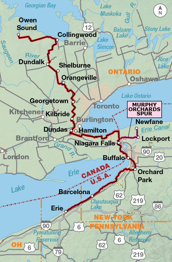
There’s a great deal of history to be explored in the Buffalo/Niagara area, ranging from that of American Revolution times to the Theodore Roosevelt Inaugural National Historic Site. This region became a natural funnel for freedom seekers, due to its remoteness, its proximity to Canada, and the anti-slavery sentiment that ran strong throughout New York State. Consequently, numerous safe houses were active on the U.S. side of the international border. One you can visit, and Buffalo’s best-known Underground Railroad site, is the Michigan Avenue Baptist Church. In the 1850s, the church building served as an Underground Railroad safe house, where freedom seekers would hide in the basement waiting to be boated across the Niagara River to Canada by night.
After crossing into Canada, from Fort Erie to Niagara-on-the-Lake the route mainly uses the Niagara River Recreation Trail, and short portions of the Niagara Parkway along the scenic Niagara River. The route near Niagara Falls is extremely busy in summer, with many international tourists visiting the area.
Numerous plaques memorializing people, structures, and events important to the Underground Railroad and other periods of black history are found on or close to the route as you proceed north through the Niagara area. Examples include a plaque at the Queenston Heights Park in Queenston, commemorating Ontario’s first Coloured Corps; and one in St. Catharines honoring Underground Railroad conductor Harriet Tubman. Considered the “Moses of Her People,” Tubman lived in this community for nearly a decade.
Murphy Orchards — found at the end of the 31.1-mile Murphy Orchards Spur, which begins at the Lewiston-Queenston Bridge — is a partner in the National Park Service’s National Underground Railroad Network to Freedom Program. Enduring legend has it that Charles and Libby McClew, who established the farmstead here in 1850, served as Underground Railroad station masters. Among other things, you can view a ten-by-twelve-foot space beneath the barn thought to have served as a hiding place. The farm is open to the public, and Underground Railroad tours are offered.
Owen Sound, where your ride of discovery ends, was known as the final terminal of the Underground Railroad. It’s where many formerly enslaved people found their hard-earned freedom, and many of them settled in the village originally called Sydenham. Every year since 1862 the community has held its Emancipation Picnic, which today celebrates two historic milestones of freedom: the British Emancipation Act of 1834 and the United States Emancipation Proclamation of 1863.
Photo by Dennis Coello
The roads and highways in Alabama and Mississippi will be flat to gently rolling. After leaving the Natchez Trace Parkway you will experience multiple climbs and descents on roller coaster hills through Tennessee, Indiana, and Kentucky.
In Ohio you’ll be riding on the many different paved rail trails that make up the Ohio to Erie Trail. The majority of roads are rural in nature and tend to be excellent for bike touring, with smooth, high quality blacktop. You’ll travel through many small towns where traffic will increase during commuting hours. The route gets hillier the farther north you head.
From Ashtabula, Ohio into Pennsylvania and New York you’ll enjoy a long stretch of flat to rolling waterside riding along Lake Erie, the southern-most of the five Great Lakes.
After crossing into Canada you’ll ride the Niagara River Recreation Trail past Niagara Falls. Throughout Ontario the route traverses the Niagara Escarpment, so expect more climbs and descents. This will provide a challenge for the fully loaded cyclist, especially when going off route for services or exploration.
| Underground Railroad - Main Route | ||||
|---|---|---|---|---|
| Section | Distance | Elevation | Total Climb | Avg. Climb/mile |
| Total | 1997.1 miles | Minimum: 0 ft.Maximum:1,760 ft. | 84,925 ft. north bound84,290 ft. south bound | 43 ft. per mi. north bound42 ft. per mi. south bound |
| 1 | 400.8 miles | Minimum: 0 ft.Maximum:495 ft. | 17,035 ft. north bound16,760 ft. south bound | 43 ft. per mi. north bound42 ft. per mi. south bound |
| 2 | 435.0 miles | Minimum: 280 ft.Maximum:730 ft. | 25,680 ft. north bound25380 ft. south bound | 59 ft. per mi. north bound58 ft. per mi. south bound |
| 3 | 378.9 miles | Minimum: 372 ft.Maximum:980 ft. | 18,290 ft. north bound18,130 ft. south bound | 48 ft. per mi. north bound48 ft. per mi. south bound |
| 4 | 404.6 miles | Minimum: 530 ft.Maximum:1,335 ft. | 9,500 ft. north bound9380` ft. south bound | 23 ft. per mi. north bound23 ft. per mi. south bound |
| 5 | 377.8 miles | Minimum: 240 ft.Maximum:1,760 ft. | 14,420 ft. north bound14,640 ft. south bound | 38 ft. per mi. north bound39 ft. per mi. south bound |
| UGRR Detroit ALT | ||||
|---|---|---|---|---|
| Section | Distance | Elevation | Total Climb | Avg. Climb/mile |
| Total | 564.7 miles | Minimum: 570 ft.Maximum:1,205 ft. | 11,525 ft. north bound11,705 ft. south bound | 20 ft. per mi. north bound21 ft. per mi. south bound |
| 1 | 340.8 miles | Minimum: 570 ft.Maximum:1,205 ft. | 5,480 ft. north bound5,645 ft. south bound | 16 ft. per mi. north bound17 ft. per mi. south bound |
| 2 | 223.9 miles | Minimum: 575 ft.Maximum:955 ft. | 6,045 ft. north bound6060 ft. south bound | 27 ft. per mi. north bound27 ft. per mi. south bound |
| UGRR Pittsburgh Spur | ||||
|---|---|---|---|---|
| Section | Distance | Elevation | Total Climb | Avg. Climb/mile |
| Total | 153.0 miles | Minimum: 645 ft.Maximum:1,545 ft. | 8,195 ft. north bound8,185 ft. south bound | 54 ft. per mi. north bound53 ft. per mi. south bound |
| Underground Railroad Alternates | ||||
|---|---|---|---|---|
| Name | Section | Distance | Total Climb | Avg. Climb/mile |
| Gravel Alternate | 1 | 4.4 miles | 190 ft. north bound450 ft. south bound | 43 ft. per mi. north bound102 ft. per mi. south bound |
| Cincinnati Spur | 3 | 16.2 miles | 735 ft. north bound780 ft. south bound | 45 ft. per mi. north bound48 ft. per mi. south bound |
| Springboro Spur | 4 | 9.9 miles | 420 ft. west bound355 ft. east bound | 42 ft. per mi. west bound36 ft. per mi. east bound |
| Caledon Alternate | 5 | 5.8 miles | 275 ft. north bound155 ft. south bound | 47 ft. per mi. north bound27 ft. per mi. south bound |
| Murphy Orchards Spur | 5 | 31.1 miles | 855 ft. east bound1,095 ft. west bound | 27 ft. per mi. east bound35 ft. per mi. west bound |
| Michigan Avenue Spur | 5 | 0.6 miles | 20 ft. north bound0 ft. south bound | 33 ft. per mi. north bound0 ft. per mi. south bound |
| UGRR Detroit ALT Alternates | ||||
|---|---|---|---|---|
| Name | Section | Distance | Total Climb | Avg. Climb/mile |
| Sandusky Spur | DET ALT 1 | 14.8 miles | 190 ft. north bound280 ft. south bound | 13 ft. per mi. north bound19 ft. per mi. south bound |
| Windsor Option | DET ALT 2 | 162.1 miles | 1225 ft. north bound1,220 ft. south bound | 8 ft. per mi. north bound8 ft. per mi. south bound |
This route can be ridden from early spring (typically April) in the south through September in the north, depending on the weather. Summers will be hot and humid. Both Alabama and Mississippi are occasionally in the path of tropical storms or hurricanes from June through November. Afternoon summer thunderstorms are typical and sometimes are accompanied by high winds and hail. While prevailing winds are generally light, Lake Erie’s shore frequently develops a localized wind pattern that may extend inland for only a few miles. In southern Ontario, the climate is highly modified by the influence of the Great Lakes. Spring brings the beginning of the tornado season, and southern Ontario has the highest frequency of tornadoes in Canada. In summer, thunderstorms can produce heavy downpours, hail, damaging winds and occasional tornadoes.
On map sections #1 and #2 of this route services between towns are often limited, so stock up on water when you can and carry extra snacks. The convenience stores in the southern states often have “southern cookin’ foods” that you would not normally find up north. After entering Ohio you’ll encounter towns at frequent intervals, and many more campgrounds to choose from. If you are riding this route early in the spring be aware that as you head north campgrounds might not be open yet so call ahead or check the internet to confirm opening dates. Conversely, some cyclists may want to do the northern portions of this route during the colors of autumn. If you do, call ahead to verify campground availability because they may close after Labor Day.
Some campgrounds will charge a cyclist traveling alone less if they have hiker/biker sites, but often they will charge the price of a regular tent or RV site, and that can easily be $10-$40/night (higher in tourist areas). The maps list churches that have opened their doors to cyclists, but they aren’t all that closely spaced. If you’re friendly and ask around, you can often get yourself invited to camp in a yard. Our routes sometimes go through national forests (moreso in the west) and you are allowed to camp anywhere on national forest land as long as you “pack it in, pack it out.” Many city parks are free to camp in.
You may also wish to sign up with Warmshowers, a reciprocal hospitality site for bicycle travelers, for other overnight options.
Route Highlights
UGRR Highlights – Section 1: Mobile Bay, AL to Fulton, MS
Mobile Bay, AL
- Former slave market in the old historic district of Mobile. This was known as the most active slave market in town.
- Big Zion AME Church at 112 S. Bayou St. was organized in 1842, now one of the oldest Black institutions in Mobile. Originally named Little Zion, but after extensive remodeling in 1896, renamed Big Zion.
- Union Baptist Church. In front of the church, visitors view the bust of Cudjoe Lewis, a member who donated the land for the church. Cudjoe was the longest living imported slave originally from Africa. After the Civil War, he settled and lived in Africatown.
- Africatown, junction of Cut Off Rd. and Bay Bridge Road. In 1860, the last shipment of slaves were brought into Mobile Bay illegally. After the Civil War, this group of Africans created their own settlement where they practiced their native tribal customs, including language. Learn more about this historic area at the Library of Congress.
- Old Plateau Cemetery Plaque and Africatown Graveyard at junction of Cut Off Rd. and Bay Bridge Road. Founded in 1876, it is the final resting place of enslaved Africans, African-Americans, and a Buffalo Soldier.
Baldwin County, AL
- Historic Blakeley State Park is the site of the last major battle of the Civil War, the Battle of Blakeley wherein nine black regiments of the U.S. Colored Troops fought.
- Montgomery Hill Baptist Church is the oldest surviving church in Baldwin County. It houses a slave gallery which provides a historical statement of the social arrangements of a slave-owning society.
- Hal’s Lake is off route and inaccessible, however this body of water is named for an escaped slave from Mississippi who lived here undetected and even recruited other slaves to his hideout. This led local plantation owners to attribute the disappearances to the Underground Railroad.
Grove Hill, AL
- Clarke County Museum at 116 Cobbs St. This museum has slave artifacts and documentation on nearby escape routes.
Lowndes County, MS
- Concord Christian Methodist Episcopal Church at 1213 Concord Rd. It was established in 1867, right after the end of the Civil War.
Columbus, MS
- Missionary Union Baptist Church at 1207 Fifth Ave. N. The oldest African American Church in northeast Mississippi. Reverend Tony Montgomery will welcome you to his flock if you stop in on Sunday.
- Columbus Public Library holds an archive collection of slavery documents, newspaper clippings and other artifacts.
UGRR Highlights – Section 2: Fulton, MS to Owensboro, KY
- Natchez Trace Parkway — Cyclists follow a small portion of this historic roadway.
Cornith, MS
- Civil War Interpretive Center is a multi-million dollar museum and part of the Shiloh National Military Park. Our photographer Dennis Coello called this museum “a real gem.” Visit the Black History Museum housing displays that tell the story of Corinth’s Black community while you’re in town. There’s also a route that follows the battles and defense works throughout town. Cornith is off route about 15 miles west of Burnsville, MS.
Shiloh, TN
- Shiloh Naitonal Military Park and Visitor Center was one of the first Civil War battles in which nearly 24,000 lives were lost in the spring of 1862. Pedaling in Shiloh is excellent and cyclists can ride a trail to a group of Indian mounds along the Tennessee River.
Savannah, TN
- Tennessee River Museum is the place to learn about the Tennessee River’s role in the Civil War and visit the Cherry Mansion which served as headquarters for General U.S. Grant in the Spring of 1862. This town also is home to the Haley Burial Site, Alex and Queen Haley, author Alex Haley’s grandparents, are buried here. Savannah is off our route aboput 4 miles east of Crump, TN.
Dover, TN
- Fort Donelson National Battlefield was the site of the Union’s first major Civil War victory under the command of “unconditional and immediate surrender” Ulysses S. Grant. This Fort was used by runaway slaves as a refuge from 1862-1865. Fugitive slaves worked for the Union Army and found assistance from Union soldiers and religious and charitable organizations. In 1863, it became a recruiting station for black troops. The Battlefield is off route about 1 mile west of the intersection of US 79 and The Trace Road.
Smithland, KY
- The Gower House was probably built in the late 1700s, and was reputed to have been used as a part of the Underground Railroad in the mid-1800s. Legend says that an underground tunnel connected it to the Massey House, a few blocks away.
UGRR Highlights – Section 3: Owensboro, KY to Milford, OH
Rockport, IL
- Lincoln Pioneer Village is a historic village just off route. Among the numerous historic buildings is the cabin in which Abraham Lincoln grew up and also on exhibit is Lincoln’s mother’s burial ground, a Living Farm and much more. Tours are by appointment during the week.
New Albany, IN
- Carnegie Center for Art & History is home to a permanent exhibit, Ordinary People, Extraordinary Courage: Men and Women of the underground Railroad in the Indiana and Kentucky Borderland.
Madison, IN
- Historic Madison — The area of Madison, known as the Georgetown Neighborhood, was an early African American settlement and important stop on the Underground Railroad after freedom seekers crossed the Ohio River from the slave state of Kentucky. Learn more at the NPS Network to Freedom website.
- Enjoy the Riverfront Walking Tour of Madison, sponsored by The Cornerstone Society, Inc. PO Box 92, Madison, IN 47250.
- African Methodist Episcopal Church Building is one of two churches established in an area know as Georgetown. The Church served the community for seventy years and is open by appointment only.
- Lanier-Schofield House* — built between 1810 and 1817 — was the first two-story brink inn and tavern in town. This historic house is available for touring, call 812-265-4759 for more information. Also visit the * Lanier Mansion State Historic Site.
- More in Madison, currently not open to the public, but worth cycling by and reading about! Visit the NPS Network to Freedom program to learn more.
- Lyman Hoyt House
- Dr. Samuel Tibbets Home
- Isaiah Walton Home
- John H. Tibbets Home
Lancaster, IN
- Historic Eleutherian College was founded in 1848 and stands as a monument to the people who established it in the name of education, the arts, and equality without regard to race or gender. This institution served as a antislavery stronghold in the pre-civil war era and was founded by Rev. Thomas Craven who dreamed of a place that whites and blacks, men and women could attend classes together. It is part of the NPS Network to Freedom program and has a visitor center located adjacent to the college building. The visitor center features exhibits and information about the history of the College and the village of Lancaster, near Madison.
- John Gill and Martha Wilson Craven Home* — another member of the NPS Network to Freedom program — Thomas Craven and his son, John Gill Craven helped start the Eleutherian Institute in 1848 which later became the College in 1854. This school, known as an “abolition school” excited opposition and John and Martha Craven opened their home to black students and freedom seekers.
Augusta, KY
- Along the route near Augusta, KY, cyclists will have the opportunity to see a host of sites and homes associated with the Underground Railroad.
- Doctor Perkins was a free person of color living in Augusta. He was charged with enticing slaves to seek their freedom. Found guilty, he was sentenced to the Kentucky State Penitentiary where he later died.
- Reynold’s Mansion and Slave Quarters — This home was built by slave labor in 1855 and the slave quarters still exist as a garage. William H. Reynolds sold his slaves prior to Lincoln’s Emancipation Proclamation.
- Taliaferro Home is a plantation style home that illustrates what living prior to 1865 might have been like. After the September, 1862 Battle of Augusta, one of General Morgan’s troops died at this site.
- Home of Nan Bass — Home to the Wm. Taylor Asbury family and slave, Nancy Jane Spencer, who became a local heroine as a nurse and mid-wife.
- Shockey Hideaway — A home built by Samuel Shockey has a hidden area under the front hall which is said to have been a place slaves were kept safe before being moved on the Underground Railroad.
- Buckhanan Home was at one time the original stage coach station and the oldest structure in the Germantown area.
- Hillsdale Road* was the site of John Gregg Fee’s school and church which held early integrated services. Fee, who began his anti-slavery career at Augusta College and graduated at Lane Seminary preached diligently against slavery. Eventually he was banished from Kentucky and his churches were burned. Fee is considered Kentucky’s most noted abolitionist and founder of Berea College. On the route, you’ll note the Bethesda Cemetery on the right hillside. The Fee farm borders this road. This is the place that Fee’s emancipated slave, Julette Miles, rescued her children from bondage. They were captured on the Ohio River west of Augusta (Rock Springs) waiting to be rowed to freedom. The Fee farm is a NPS Network to Freedom site.
- Julette Miles Site was the location of John Fee’s school and church which held integrated services. Fee, a student at Augusta Methodist College and Lane Seminary was in charge of young missionaries distributing religious materials in the area. Fee’s emancipated slave, Julette, rescued her children from bondage.
- General Payne Home* built in circa 1813. Later Dr. Jonathan Bradford lived here. Newspaper accounts of the time report it as a safe house and Dr. Bradford was know to have ties to Arthur Thome, an area conductor.
- White Hall*, part of the Network to Freedom program, is a grand mansion that was home to conductors Arthur and James A. Thome. Built by slave labor circa 1809 before Thome freed his slaves in the 1830’s. Arthur became a conductor before leaving Augusta in 1842. James became a Lane Seminary debater/rioter and Oberlin College graduate where in 1839, he fled after leading Judah, a female slave living with the local Chalfont family, on the Underground Railroad. James wrote Emancipation of the West Indies at White Hall and co-authored a book with the famous Theodore Weld.
- Fee and Gragston Historical Marker recognizes Fee, an abolitionist, and Gragston, a conductor on the Underground Railroad.
- Slave Jail — Pinecrest Farm’s barn contained the “jail” with barred windows and chains used to secure Africans waiting to be shipped down river to Natchez, MS. This “jailhouse” has been removed and restored and is now a focal point at the National Underground Railroad Freedom Center in Cincinnati, OH.
Washington, KY
- In Historic Washington see the historic attractions and learn about Old Washington and the Underground Railroad.
- The Harriet Beecher Stowe Slavery to Freedom Museum displays slavery artifacts and Civil War memorabilia, period furnishing and chronicles the life of Ms. Stowe, author of the book “Uncle Tom’s Cabin.”
- The Kentucky Gateway Museum Center* transports visitors through time as it tells the story of the region through dioramas and exhibits.
Maysville, KY
- Maysville, KY is home to the The National Underground Railroad Museum at the Bierbower House, which was a documented safe house and provides a view of the original kitchen and slave quarters where fugitive slaves were hidden under false floors.
Ripley, OH
- Ripley, Ohio is also known as “Freedom’s Landing.” This community was well known for abolitionist activity and was a major station on the Underground Railroad.
- John Rankin House was home to the Rankin Family who moved hundreds of freedom seekers along the Underground Railroad, including the woman who inspired “Eliza,” the fictional heroine of Harriet Beecher Stowe’s book, Uncle Tom’s Cabin.
- John Parker House — After purchasing his freedom, John Parker became one of the most daring conductors on the Underground Railroad, sneaking across the Ohio River to aid freedom seekers.
Clermont County, OH
- Clermont County’s Freedom Trail lists a number of Freedom Stations which are part of the NPS Network to Freedom program. You can learn more about these sites by downloading a Freedom Trail brochure from the county’s website. The following sites are along the Underground Railroad Bicycle Route.
- Marcus Sims — Huber Tannery, Williamsburg
- Charles B Huber Home Site, Williamsburg
- Dr. Leavitt Thaxter Pease Home, Williamsburg
- Williamsburg Township Cemetery, Williamsburg
- Charles B Huber Farm, Williamsburg
- Brice Blair Home, Batavia
- John Joliffe & Clermont County Courthouse, Batavia
- Philip Gatch Burial Site & Greenlawn Cemetery, Milford
Cincinnati, OH
- The National Underground Railroad Freedom Center is home to three pavilions that celebrate courage, cooperation and perseverance. The story of freedom is woven through the heroic legacy of the Underground Railroad and the American struggle to abolish human enslavement and secure freedom for all people.
- Harriet Beecher Stowe House, 2950 Gilbert Avenue. This house was once home to the author of Uncle Tom’s Cabin.
* Denotes a site not listed on the map.
UGRR Highlights – Section 4: Milford, OH to Erie, PA
Waynesville, OH
- Caesar’s Creek Pioneer Village — A 1700’s Quaker Village.
- Museum at the Friends Home displays historic Quaker living history exhibits.
- Harveysburg First Free Black School* — 6 miles east of Waynesville, was the first free black school in Ohio. Tour by appointment: 513-897-6195.
Springboro, OH
- Springboro — Settled by Quakers and home to over 17 Underground Railroad sites. Call the Historical Society 937-748-0916 for a historic walking tour brochure.
- Wright House Bed & Breakfast — Home to Springfield’s founding father displays authentic slave hiding place and slave artifacts. Call 937-748-0801 to set up a tour.
Xenia, OH
- Monroe House and the city of Xenia — This town is more than just a bike trail hub.
Wilberforce, OH
- National Afro-American Museum and Cultural Center depicts life for African American’s through the decades. Located on the campus of Central State University and Wilberforce University.
- Martin Delany Gravesite is north of Wilberforce. Learn about Delany’s contribution to the abolition movement and visit this monument erected in 2006.
Greene County, OH
- Greene County, Ohio, is proud of their African American History. Check out the history at their Convention and Visitor’s Bureau website.
- Yellow Springs is home to Antioch College. This educational institution is known for working toward social justice.
Columbus, OH
- Step back in time by visiting the perfectly preserved Kelton House Museum and Garden, an 1852 home that was part of the Underground Railroad.
Mt. Vernon, OH
- The Mount Calvary Baptist Church is a Gothic revival church built in 1915 that had an entirely African-American congregation at the time.
Massillon, OH
- Spring Hill Historic Home was the home of the Rotch-Wales families from 1821-1973. In the 1820s, the house was used as a station on the Underground Railroad, assisting freedom seekers as they moved north.
Peninsula, OH
- Ohio and Erie Canal National Heritage Corridor* offers a side trip worth exploring.
- Peninsula Village Historic District* and the Cuyahoga Valley Historical Museum* was organized for the purpose of interpreting and promoting the area’s history.
Hudson, OH
- Hudson is home to as many as 19 known Underground Railroad Sites. Download a list of sites from the Hudson Library and Historical Society archives.
- First Congregational Church was founded by David Hudson. The church split and Owen Brown, John Brown’s father, founded the Free Congregational Church in Hudson. After the Civil War the two churches joined together again.
Burton, OH
- Century Village has a collection of historic 100+ year old buildings owned and preserved by the Geauga County Historical Society. Take a walk and enjoy.
Jefferson, OH
- Joshua R. Giddings Law Office* and museum. Open by appointment. U.S. Congressman Giddings was forced to resign after he was censured for speaking on behalf of slaves who mutinied while being transported. Jefferson is off route about 5 miles east of Austinburg, OH.
Ashtabula, OH
- Hubbard House Underground Railroad Museum features Underground Railroad and Civil War exhibits.
Girard, PA
- Hazel Kibler Museum at 522 E. Main St. This museum features exhibits showcasing local Underground Railroad sites. Also visit nearby Universalist Church, a station on the Underground Railroad. Call 814-774-3653 for directions and more information. Girard is off route about 2 miles south of Lake City, PA.
Erie, PA
- St. James AME Church. This is the oldest African American church in the city. It was organized in 1874. 814-456-4011.
- The Erie Maritime Museum & U.S. BRIG NIAGARA focuses on the role of African Americans in the battle of Lake Erie in the War of 1812.
* Denotes a site not listed on the map.
UGRR Highlights – Section 5: Erie, PA to Owen Sound, Ontario, Canada
Dunkirk, NY
- Dunkirk Historical Museum, 513 Washington Ave. View Civil War exhibit and area history.
Orchard Park, NY
- Obadiah Baker Homestead and Historical Marker at E. Quaker St. and Baker Rd. This preserved house was a refuge station and part of the Quaker community that spoke out against slavery.
Buffalo, NY
- For more information about African American history in the Buffalo region visit the Buffalo Niagara Convention and Visitors Bureau
- Michigan Street Baptist Church, 511 Michigan Ave. This Underground Railroad station is the oldest property continuously owned/operated by African Americans and was part of the history of Buffalo’s African American community.
- Mary B Talbert Historical Marker lies adjacent to the Church. Talbert was a civil rights leader who helped organize the “Niagara Movement,” which later became the NAACP.
- J. Edward Nash House, 36 Nash St. Named for the pastor of the Michigan Street Baptist Church who, with Mary Talbert, helped organize the “Niagara Movement”, the forerunner to the NAACP.
- Motherland Connextions Inc. offers tours about Underground Railroad and slide shows.
- African American Cultural Center, 350 Masten Ave. Showcases the talents of African American playwrights, directors and actors.
- Ujima Company, Inc., at 429 Plymouth Ave., Suite 2. A professional theatre company dedicated to the development and presentation of work by African Americans and other third world artists.
- Broderick Park and Historic Marker. Before the Peace Bridge existed, this was an important launching site for freedom seekers who had been hiding in the Michigan Street Baptist Church, traveling by boat over the narrowest part of the Niagara River to Canada. Every year the Harriet Tubman 300 and the Buffalo Quarters Historical Society run a memorial service at this site to honor conductors who risked their lives to help freedom seekers gain independence in Canada.
Fort Erie, ON
- Niagara Freedom Trail Plaque describes the ferry system used by freedom seekers to cross the river to Canada. Located southeast of the Peace Bridge near Historic Fort Erie.
- Dollhouse Museum (Bertie Hall) was a known safe house where smuggling operations were rumored to have taken place using an underground tunnel in the basement. 905-871-5833.
- Little Africa Plaque at Niagara Parks Commission Marina (formerly Miller’s Bay Marina). This site was originally the export point for lumber coming from “Little Africa,” a settlement established in the 1840s.
Niagara Falls, ON
- Nathaniel Dett BME Church. Visit this historic church which served freedom seekers as they made new lives in Canada.
Queenston, ON
- Lewiston-Queenston Bridge, known as the “Freedom Crossing”, was used by Harriet Tubman en route from slavery in Maryland to her first home in Ontario in 1849. It became a major route for freedom seekers.
- Colored Corps Historic Plaque is where the Canadian Black Militia formed at the start of the War of 1812. They assembled here and set the precedent for units established elsewhere in Canada.
Lockport, NY
- Freedom Run Winery is located on the spur that goes to Murphy Orchards. Freedom Run Winery is owned by the Manning family and celebrates and supports Freedom for all. Their mission is to give back what the land has gracefully given them by producing premium wines and champagne in order to dedicate service to the community and to others.
Newfane, NY
- Murphy Orchards is on a spur route near Newfane, NY. This privately owned farm was part of the Underground Railroad from 1850-1861. The farmhouse, barn, orchards, and landscape remain as they did 150 years ago, complete with a viewable hiding place in the barn.
Niagara-on-the-Lake, ON
- Negro Burial Ground Historic Plaque was previously the Calvinistic Baptist Church. John Oakley, a former British soldier, became pastor to the mostly Black congregation.
St. Catharines, ON
- In 1793, the “Upper Canada Act Against Slavery” was passed, allowing Blacks aged 25 years and older freedom from slavery in Canada. This created a safe haven for African American runaway slaves and made Canada the destination for many who fled. As a result, hundreds of escaped slaves settled in St. Catharines and created a vibrant Black community
- St. Catharines Museum and Welland Canal Centre, 1932 Welland Canal Pkwy. Experience the rich legacy of Niagara’s African Canadians in the integrated Follow the North Star exhibit.
- Anthony Burns Grave Site & Victoria Lawn Cemetery. Historic marker honors Rev. Anthony Burns, the last person tried under the Fugitive Slave Act in Massachusetts.
- Richard Pierpoint Historic Marker in Centennial Park honors Pierpoint’s years of military service to the Crown.
- The BME Church (Salem Chapel) — Many freedom seekers attended church and meetings at this Church, including Harriet Tubman. The Salem Chapel, British Methodist Episcopal Church was the first Black church in St. Catharines. Originally known as the African Methodist Episcopal Church, the name was changed to reflect their loyalty to the British Empire. Contact Ada Summers 905-984-6769 for more information.
Collingwood, ON
- Sheffield’s Black Cultural Museum, Long Point Rd. View slave artifacts and learn the history of early Black pioneers who settled this region. The museum is just off route 2 miles west of Collingwood.
Owen Sound, ON
- Owen Sound developed and grew as freedom seekers settled in the area. Learn more about the freedom seekers who began arriving around 1830 from the Owen Sound Black History website. The City of Owen Sound was first named Sydenham and officially changed the name to Owen Sound in 1857.
- BME Church served the needs of former slaves arriving on the Underground Railroad and are considered the founders of the Annual Emancipation Festival that takes place the first weekend of August since 1862.
- Grey Roots Museum & Archives provides a living link for the legacies of the past, artifacts, and stories. See the exhibit From Slavery to Freedom, African Canadians in Grey County.
- Black History Cairn at Harrison Park. In 2004, this commemorative Cairn, (Cairn defined as “a rounded heap of stones”) was unveiled as a memorial to Owen Sound’s Black settlers.
Recommended Reading, Underground Railroad
Here are a few books that we recommend:
- Bound for Cannaan, The Underground Railroad and the War for the Soul of America by Fergus M. Bordewich
- Bound For The Promised Land: Harriet Tubman, Portrait Of An American Hero By Kate Clifford Larson, see also www.harriettubmanbiography.com
- Beyond the River, The Untold Story of the Heroes of the Underground Railroad by Ann Hagedorn
- I’ve Got a Home in the Glory Land, A Lost Tale of the Underground Railroad by Karolyn Smardz Frost, see also www.homeingloryland.com
- The Town that Started the Civil War by Nate Brandt
- The Underground Railroad in Michigan by Carol E. Mull
- Underground Railroad Official National Park Handbook includes essays by Larry Gara, Brenda Stevenson and C. Peter Ripley. You may purchase by mail from the Superintendent of Documents, US Govt. Printing Office, Washington, D.C. 20402-9325
- Uncle Tom’s Cabin by Harriet Beecher Stowe
For additional reading lists:
- Friends of Freedom Society – The Ohio Underground Railroad
- Ottawa Citizen’s Tracks to Freedom,Canada and the Underground Railroad posts a reading list and African American Spirituals sung by Norma Blacke Bourdeau
- Motherland Connextions, Inc. — A tour company in Niagara, NY that’s done their research!
- Juvenile Reading List from the National Park Service
Online Reading:
- Exploring a Common Past, Researching and Interpreting the UGRR by the National Park Service
- Oberlin Archives a bounty of resources on Oberlin’s history
- For the writings of Theodore Weld
- Actual writing by slave and slave holders – reprints of American Slavery As It Is: Testimony of A Thousand Witnesses
- Martin Delaney‘s story
- Library of Congress – read slave narratives

More Route Resources
- How to Travel with your Bike on Amtrak
- Fulton Underground Railroad Historical Marker (Mississippi)
- No-Turn-Away Bike Camping Policies (Tennessee)
- Natchez Trace Parkway (Alabama, Mississippi, Tennessee)
- Land Between the Lakes National Recreation Area (Tennessee, Kentucky)
- The Purple People Bridge (between Kentucky and Ohio)
- Ohio Freedom Path audio guide app (for Android) (Ohio)
- Ohio Freedom Path audio guide app (for Apple) (Ohio)
- Ohio to Erie Trail (Ohio)
- Little Miami Scenic Trail (Ohio)
- Great Miami Riverway Alternate (Ohio)
- Xenia Station (Ohio)
- Prairie Grass Trail (Ohio)
- Roberts Pass Trail (Ohio)
- Camp Chase Trail (Ohio)
- Scioto Greenway (Ohio)
- Olentangy Trail (Ohio)
- Heart of Ohio Trail (Ohio)
- Kokosing Gap Trail (Ohio)
- Mohican Valley Bike Trail (Ohio)
- Holmes Country Trail (Ohio)
- Sippo Valley Trail (Ohio)
- Ohio and Erie Canal Towpath Trail (Ohio)
- Cuyahoga Valley National Park (Ohio)
- Western Reserve Greenway Trail (Ohio)
- USBR 30 (Ohio)
- USBR 30 (Pennsylvania)
- U.S./Canadian border crossing information
- Niagara River Recreation Trail (Ontario)
- Caledon Trailway (Ontario)
- Georgian Trail (Ontario)
- Connect and share photos with other riders on Instagram: #acaUGRR
Recommended Reading
There are a number of books and articles that reveal the true history and stories of the Underground Railroad. View our recommended reading list.
Roots of the Underground Railroad Route
The project was born in 2004 when Adventure Cycling began a partnership with the Center for Health Equity at the University of Pittsburgh to further encourage people from all walks of life and cultural backgrounds to explore America’s landscapes and history by bicycle. Combined with the nation’s burgeoning health crisis, Adventure Cycling and the Center for Health Equity saw a natural alliance with common goals.
Adventure Cycling contacted historians, preservationists, and researchers and asked: “How do you pick a single route that represents thousands of escape routes?”
During this period of slavery, the tribal custom of creating songs to transmit information was used to communicate between slaves from plantation to plantation. Adventure Cycling chose to map the first part of the route guided by the song, “Follow the Drinking Gourd.” This song refers to following the North Star and waterways to the Ohio River — in essence, it describes an escape route from Alabama and Mississippi. Upon reaching the Ohio River, Adventure Cycling relied on the knowledge and efforts of members and outside experts to steer the route to rich historic destinations while maintaining Adventure Cycling’s standards of great cycling roads and paths.
Successfully meeting the goals of the Underground Railroad Bicycle Route continues to depend upon the contribution of volunteers, members, Underground Railroad enthusiasts, historians, health advocates and more.
Core Planning Team
Mario Browne, MPH, CHES; Chuck Harmon; Anthony Ratajczak; Todd Scott; Stephen Thomas PhD
Advisory Board, Main Route
Jonas Chaney, broadcast veteran; Dr. Randall R. Cottrell, Texas A&M University; Wes Dean, division administrator for the Traffic Engineering Division, Jackson, Mississippi; Laurence Glasco, associate professor of history, University of Pittsburgh; Katherine Kraft, independent consultant in environmental and policy approaches to promoting healthy lifestyles; Keith Laughlin, president, Rails-to-Trails Conservancy; Sarah (Jameela) Martin; Barbara Murock, health policy specialist, Executive Office of the Allegheny County Department of Human Services; George Needham, vice president for member services, OCLC Online Computer Library Center in Dublin, Ohio; Jim Rotch, corporate attorney and partner at Bradley, Arant, Rose & White, LLP & author of The Birmingham Pledge & Chair, Birmingham Pledge Foundation; Becky J. Smith Ph.D., CHES, CAE, executive director, American Association for Health Education and vice president of the American Alliance for Health, Physical Education, Recreation, and Dance; Floyd Thomas, Jr., chief of the Curatorial/Exhibitions Division, National Afro-American Museum and Cultural Center in Wilberforce, Ohio; Catherine Walker, vice president, general counsel, and corporate secretary, REI.
Advisory Board, Detroit Alternate
Barb Bickel, executive director, Visit Lorain County; Nancy Darga, managing director, MotorCities National Heritage Area; Deborah Johnson, clinical therapist; Joe Levin, board member, Michigan Trails and Greenways Alliance; Carol E. Mull, author of The Underground Railroad in Michigan; Joseph D.R. Tanner, administrative generalist and educational outreach specialist, The Hub of Detroit; Kimberly L. Simmons, founding president and executive director, Quarlls Watkins Heritage Project; Leslie C. Strong Williams, president, Fred Hart Williams Genealogical Society; Kathryn Underwood, city planner, Detroit Planning Commission.
Auxiliary Members and Advisors
Richard Bailey, PhD, University of Kentucky; professor of history, Canisius College, Buffalo, NY; Don Burrel, bike/ped coordinator, OKI Regional Council of Governments; Anthony Cohen, founder and president, Menare Foundation; Sonja Cropper, economic development and tourism director, Brown County, OH; Jim Coppock, Bicycle Transportation Program, Dept. of Transportation, Cincinnati, OH; Betha Gutsche, WebJunction community associate, Seattle, WA; Rose Hall, Major Taylor Association, Worcester, MA; Cathy Nelson, founder, Friends of Freedom Society, OH; Dennis Scott, director, Owen Sound Annual Emancipation Day Festival; Guy Washington, regional coordinator, The National Park Service Network to Freedom Program.
Updates to Recently Released Maps
If you are planning a bike tour, be sure to get the most recent map updates and corrections for your route by selecting the route, and the appropriate section(s), from the drop-down menu below.
Over time maps become less useful because things change. Every year Adventure Cycling’s Routes and Mapping Department create map updates and corrections for every map in the Adventure Cycling Route Network, which now totals 52,047 miles. With the help of touring cyclists like you, we receive updates on routing, services, camping, and contact information. Until we can reprint the map with the new information, we verify the suggested changes and publish corrections and updates here on our website.
PLEASE NOTE: Covid has been particularly hard on the small businesses along our routes. While we do our best to keep the maps and these online updates current, you may encounter more closed businesses and longer stretches with limited or no services.
Refer to these updates for the most current information we have and submit reports of changes to the Route Feedback Form for the cyclists coming after you.
NOTE: Map updates and corrections only pertain to long term changes and updates. For short term road closures, please see the Adventure Cycling’s Routes Temporary Road Closures discussion in our Forums.