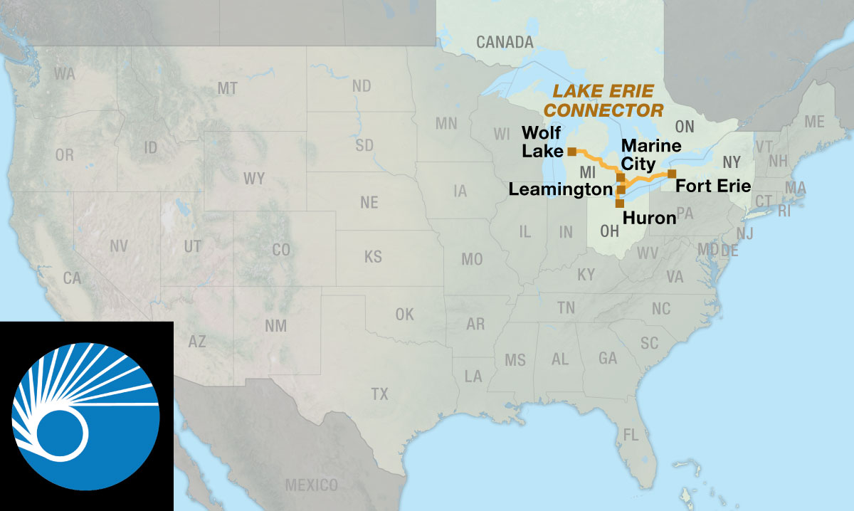
Lake Erie Connector
Connecting the North Lakes and Northern Tier routes.
The Lake Erie Connector is intended primarily as a shortcut that saves about 250 miles between the North Lakes Route near Wolf Lake, Michigan, and the Northern Tier Route at Fort Erie, Ontario. It also connects to the Northern Tier Route across the western end of Lake Erie at Sandusky, Ohio, and enables a variety of loop rides in the lower Great Lakes region.
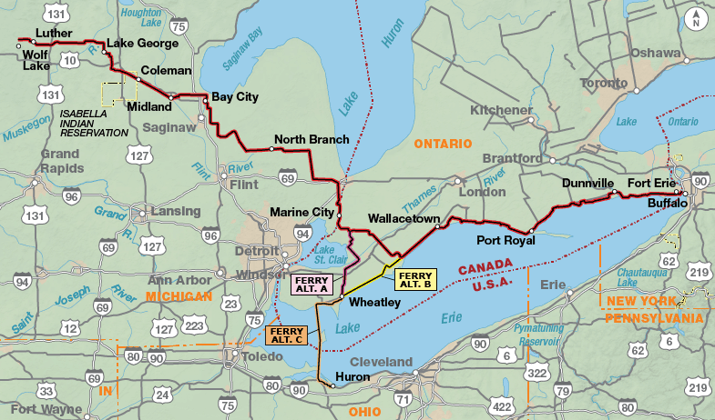
The route begins near Wolf Lake, Michigan. It passes through the sparsely populated rural landscape of rolling fields and forests of west-central Michigan to Clare. From here, the route follows 30 miles of the paved Pere Marquette Rail-Trail to Midland. The rail-trail ends in a park at the confluence of the Tittabawassee and Chippewa rivers, spanned by the “Tridge,” a unique three-legged bridge spanning the confluence. The route passes through pleasant residential neighborhoods in Midland to begin its traverse of the “thumb” of Michigan. From Bay City, the route stair-steps across and down the “thumb” to the city of St. Clair and then along the St. Clair River to Marine City. The “thumb” is a nearly treeless area of intensively cultivated farmland and is almost flat. At Marine City, the route uses a ferry to cross the St. Clair River to Sombra in Ontario, Canada. There is a short and pleasant ride along the St. Clair River, and then the route turns inland to the city of Wallaceburg. Here the route splits, with the main route continuing to Fort Erie, Ontario, and the Ferry Alternate going southward for ferry connections to Sandusky, Ohio and the Northern Tier Route. The area surrounding Leamington is the tomato-farming region of Canada, and Leamington is a major tomato-processing center. Those riding through the area at harvest will see mechanical tomato harvesters in fields and trucks with huge loads of tomatoes.
The ferry connecting Ontario and Ohio stops at Pelee Island, itself an interesting destination. The main route continues east from Eatonville, closely following the Lake Erie shore. High sand bluffs drop down to the lake, and south breezes cool the cyclist. The only hills encountered along the lakeshore are where the route dips down to the rivers and the small towns nestled there. As the route proceeds east from the tomato region, it enters Canada’s tobacco belt. During harvest, cyclists will see tractors pulling long steel trailers that look like double coatracks hauling loads of tobacco leaves and small barns without windows used for drying the tobacco. The towns along the lake are small. Those with “port” in their names are the significant towns. Port Stanley is a trendy town with an arts community. Port Dunnville and Port Colborne are the largest. Port Colborne is significant as the Lake Erie entrance to the Welland Canal, the marine link between Lakes Erie and Ontario. Take some time in Port Colborne to explore the Welland Canal, and watch the freighters negotiate the Niagara Escarpment. East of Port Colborne, the area becomes increasingly residential as it approaches Fort Erie.
This route is basically flat with several gently rolling sections.
| Lake Erie Connector - Main Route | ||||
|---|---|---|---|---|
| Section | Distance | Elevation | Total Climb | Avg. Climb/Mile |
| Total | 506.7 miles | Minimum: 565 ft.Maximum:1,365 ft. | 9,655 ft. east bound9,945 ft. west bound | 19 ft. per mi. east bound20 ft. per mi. west bound |
| Lake Erie Connector Alternates | ||||
|---|---|---|---|---|
| Name | Section | Distance | Total Climb | Avg. Climb/Mile |
| Ferry Alternate A | 1 | 46.2 miles | 320 ft. south bound300 ft. north bound | 7 ft. per mi. south bound6 ft. per mi. north bound |
| Ferry Alternate B | 1 | 40 miles | 955 ft. south bound1025 ft. north bound | 24 ft. per mi. south bound26 ft. per mi. north bound |
| Ferry Alternate C | 1 | 29.3 miles | 545 ft. south bound525 ft. north bound | 19 ft. per mi. south bound18 ft. per mi. north bound |
Services are plentiful and evenly spaced throughout Michigan. Bike shops are located in several of the larger towns. Note that there are few grocery stores on route along the Lake Erie shore in Canada. Cyclists need to carefully plan in anticipation of where they will spend the night. Campgrounds and B&Bs are plentiful along the lake; with few exceptions there are motels. The lakeshore is a popular vacation destination, and reservations are advised at the B&Bs and campgrounds.
Some campgrounds will charge a cyclist traveling alone less if they have hiker/biker sites, but often they will charge the price of a regular tent or RV site, and that can easily be $10-$30/night. If you’re friendly and ask around, you can often get yourself invited to camp in a yard. Our routes sometimes go through national forests (moreso in the west) and you are allowed to camp anywhere on national forest land as long as you “pack it in, pack it out.” Many city parks are free to camp in.
You may also wish to sign up with Warmshowers, a reciprocal hospitality site for bicycle travelers, for other overnight options.
Note that most of the rural roads in Michigan and Ontario are dirt — very dusty when dry and very muddy when wet. What may look like a tempting shortcut down a paved road may become a miserable ride on a dirt road. This route has been carefully researched to avoid such roads, so cyclists are advised to stay on route. Even though the route in Canada at times is on main arterials, the speed limit is low (80 kph/50 mph), and motorists obey the speed limit. Canada is on the metric system and all road distances shown on signs are in kilometers. This route can be ridden from early spring to late fall (typically April to October). Summers can be hot and humid, so be prepared. During the summer months, winds are predominantly from the southwest. While prevailing winds are generally light, Lake Erie’s shore frequently develops a localized wind pattern that may extend inland for only a few miles.
Route Highlights
Lake Erie Connector Highlights
- Bay City, Michigan
- Frankenmuth, Michigan
- Pelee Island, Ferry Alternate
- Uncle Tom’s Cabin Historic Site, Ontario
- Welland Canal, Ontario
- Niagara Falls, Ontario
- Historic Fort Erie, Ontario
More Route Resources
- U.S. Bicycle Route System
- U.S. Bicycle Route 20 (Michigan)
- No-Turn-Away Bike Camping Policies (Michigan)
- Michigan DOT bike maps
- U.S./Canada Visa Information
- Pere Marquette Rail Trail (Michigan)
- Bay City Riverwalk Trail (Michigan)
- Southern Links Trailway (Michigan)
- Wadhams to Avoca Trail (Michigan)
- Bridge to Bay Trail (Michigan)
- Bluewater Ferry (Michigan-Ontario)
- Friendship Trail (Ontario)
- Leamington and Kingsville ferries (Ontario)
- Pelee Island Information (Ontario)
- Connect and share photos with other riders on Instagram: #acaLakeErie
Updates to Recently Released Maps
If you are planning a bike tour, be sure to get the most recent map updates and corrections for your route by selecting the route, and the appropriate section(s), from the drop-down menu below.
Over time maps become less useful because things change. Every year Adventure Cycling’s Routes and Mapping Department create map updates and corrections for every map in the Adventure Cycling Route Network, which now totals 52,047 miles. With the help of touring cyclists like you, we receive updates on routing, services, camping, and contact information. Until we can reprint the map with the new information, we verify the suggested changes and publish corrections and updates here on our website.
PLEASE NOTE: Covid has been particularly hard on the small businesses along our routes. While we do our best to keep the maps and these online updates current, you may encounter more closed businesses and longer stretches with limited or no services.
Refer to these updates for the most current information we have and submit reports of changes to the Route Feedback Form for the cyclists coming after you.
NOTE: Map updates and corrections only pertain to long term changes and updates. For short term road closures, please see the Adventure Cycling’s Routes Temporary Road Closures discussion in our Forums.