Sierra Cascades

Sierra Cascades Blaine, WA to Tecate, CA 5 Map Set GPX Data | Overview | Buy | Mobile App
1. Blaine, WA to Mt. Rainier NP, WA Detail
2. Mt. Rainier NP, WA to Crater Lake NP, OR Detail
3. Crater Lake NP, OR to Truckee, CA Detail
4. Truckee, CA to Lake Isabella, CA Detail
5. Lake Isabella, CA to Tecate, CA Detail

Take an adventure along the stunning Pacific Crest.

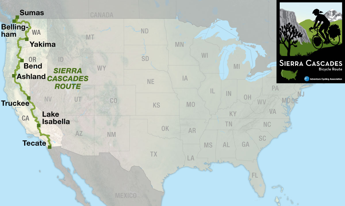
The Sierra Cascades Bicycle Route runs roughly parallel to the Pacific Crest National Scenic Trail along the Cascade Range and Sierra Nevada from the Canadian border to the Mexican border. This route is characterized by volcanoes, long stretches of forested countryside, busy towns, deserts, orchards and everything in between.

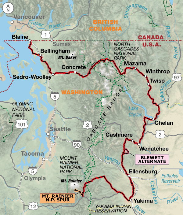
Section 1 begins at the Peace Arch Historical State Park next to the Canadian/U.S. border in Blaine, Washington. The first 30 miles of the route stays low on the coastal plain as it meanders through Bellingham, an outdoorsy college town that boasts train, plane and bus services. In Sedro-Woolley the route joins the Skagit River and parallels State Highway 20, which are followed eastward and upward into the main heart of the Cascade Range. Along the entire route you’ll cross 20 passes and 25 Pacific Crest Trail crossings, though some of these are unmarked. Due to heavy snow, State Highway 20 through the North Cascades National Park is usually only open between late April and late November. From Sedro-Woolley to Yakima this route shares the same routing with our Northern Tier and Washington Parks routes. On the east side you’ll be traveling through orchard country, where the roads will get busier during harvest times. West of Yakima the route heads to Mt. Rainier National Park. A spur is shown to the Paradise Visitor Center within the Park. Expect heavy traffic in and near the Park from June through August.
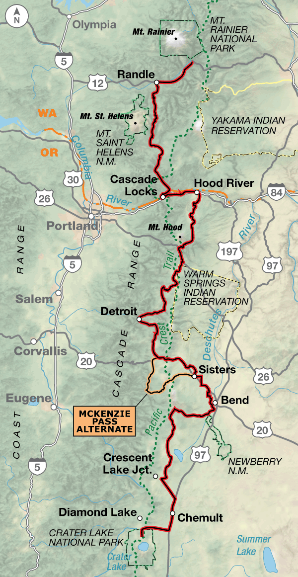
After Mt. Rainier National Park, the route runs south through many miles of national forest land on lightly-trafficked roads to the wind surfing area of the Columbia Gorge. The busy roads along the Columbia River will have tourist, recreational, and commercial traffic. There are 6 miles of riding on the shoulders of I-84 due to the fact that there are no other roads to use along the river. At Hood River, Oregon, the route turns south, circling around the eastern and southern flanks of Mt. Hood. From there you’ll ride through another long stretch of national forest land until reaching the suburbs of Bend, on the dry side of the Cascades. Stock up here because there’s one more long stretch of national forest land with its recreation opportunities, so expect more traffic on weekends. Crater Lake National Park is the endpoint of section 2, and again, expect heavier traffic on the road through the Park. The 59.7-mile McKenzie Pass Alternate follows paved state highways. It is more scenic, has less traffic, and offers a great view at the top of the pass in all directions. This section intersects the Lewis & Clark Bicycle Trail in Hood River and the TransAmerica Trail in Sisters, Oregon.

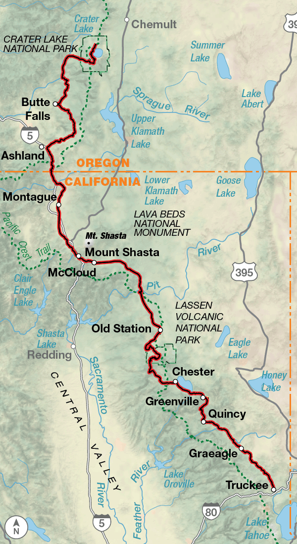
On section 3, after leaving the spectacular scenery of Crater Lake, the route continues south to Ashland, Oregon, home of the Oregon Shakespeare Festival. Then it’s across the border into California toward towering Mt. Shasta in the distance. You’ll have to ride on the shoulders of I-5 for 8.4 miles, again due to the fact that there are no other roads to use. You’ll bike through the remains of volcanic history in Lassen Volcanic National Park and end near the California/Nevada state line in Truckee. Reno, Nevada is located about 30 miles northeast and is a good connection point if you want to start the route at midpoint. Search the internet for available shuttle services.

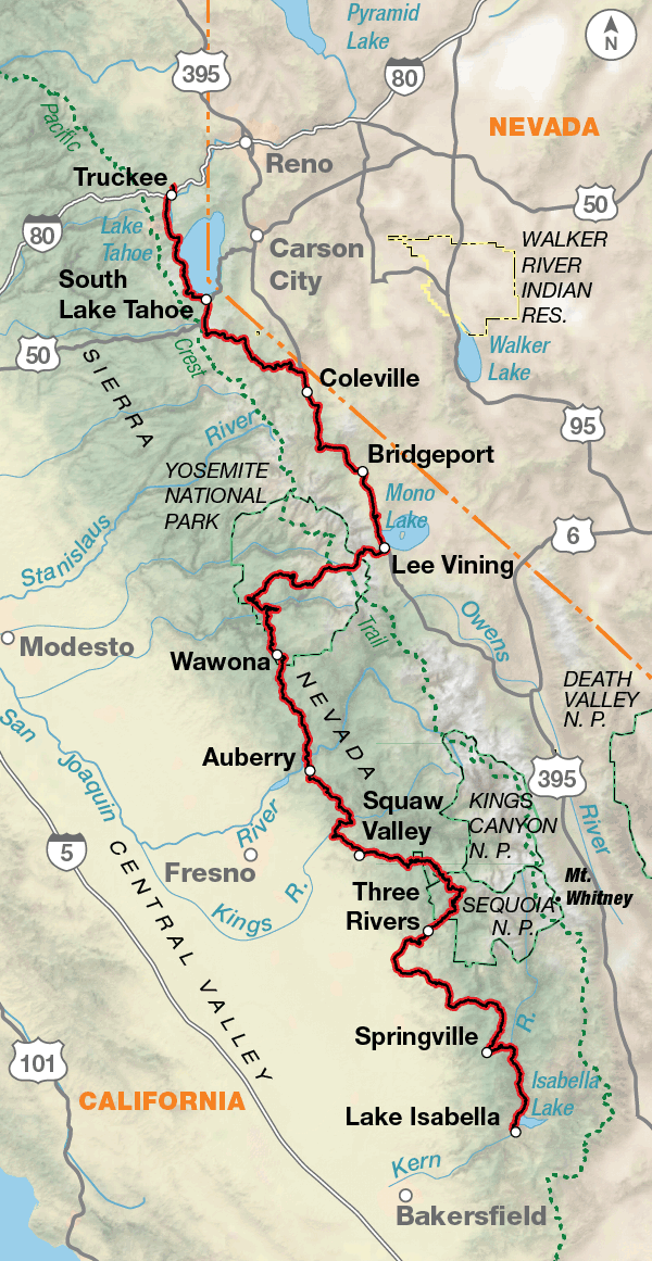
Leaving Truckee, you’ll circle the western half of Lake Tahoe, then climb into the Sierra Nevada. Several of the passes on this section are closed during the winter, and might not open until late spring/early summer if it’s been a heavy snow year. You can check road opening dates on the California Department of Transportation’s website listed on the map. There’s a 66.2-mile stretch of riding U.S. 395, a major thoroughfare on the eastern side of the range. At Lee Vining, you’ll leave U.S. 395 and head west over Tioga Pass into Yosemite National Park. Expect heavy traffic in the parks during the summer tourist season. There are technically three national parks on this section, Yosemite, Kings Canyon, and Sequoia, but the last two are administered together. When traveling through you may want to build in some extra days to explore activities off the bike like climbing in Yosemite or hiking the Trail of a Hundred Giants in the Giant Sequoia National Monument. Lake Isabella, the endpoint for section 4, is located northeast of Bakersfield. This section intersects the Western Express Bicycle Route in Woodfords, California.

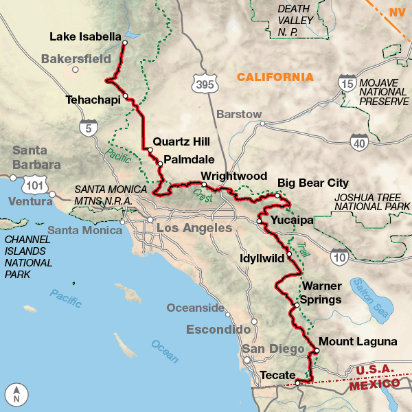
Lakes, mountains, valleys, and deserts, section 5 has them all! Highlights include the Mohave Desert, the San Gabriel Mountains, the San Gorgonio Mountains, the Anza-Borego Desert and the rustic small town of Idyllwild against the background of the San Jacinto Mountains. There are also plenty of scenic byways on the route beginning with the Angeles Crest, then the Rim of the World, and finally the Sunrise Scenic Byway. Remember that the megalopolis of Los Angeles and its surrounding cities isn’t too far to the west so expect higher levels of traffic near these byways, especially on weekends. The route ends at Tecate at the Mexican border. This section intersects with the Southern Tier Bicycle Route in Pine Valley, California.

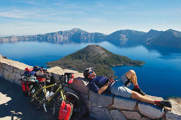
Photo by Gregg Bleakney

The Sierra Cascades route lets you warm up slightly before the first major climb to Rainy Pass at 4,855 feet. Once you cross to the eastern side of the Cascades, the route will be rolling and following river valleys until Old Blewett Pass. West of Yakima, Washington, is where the climbing begins to approach Mt. Rainier National Park. The route begins climbing and descending passes until the Columbia River Gorge where it’s mostly level riding, then there will be more climbs and descents south of Mt. Hood all the way to Crater Lake National Park. On section 3, and at the beginning of section 4, the route stays on the eastern side of the Cascade Range but still expect rolling terrain. You’ll climb into the Sierra Nevada south of Lake Tahoe (more passes), then stay at slightly higher elevations along U.S. 395. Tioga Pass, at 9,945 feet, is the eastern entrance to Yosemite National Park and is the highest pass along the route. As you continue southward, the route continues to go up and down and becomes more rolling as you reach the border.

Sierra Cascades - Main Route
Section Distance Elevation Total Climb Avg. Climb/mile
Total 2441.1 miles Minimum: 0 ft.
Maximum:9,945 ft.
195,975 ft. south bound
194,310 ft. north bound
80 ft. per mi. south bound
80 ft. per mi. north bound
1 484.0 miles Minimum: 0 ft.
Maximum:5,460 ft.
27,480 ft. south bound
26,340 ft. north bound
57 ft. per mi. south bound
54 ft. per mi. north bound
2 452.5 miles Minimum: 75 ft.
Maximum:6405 ft.
32,715 ft. south bound
28,245 ft. north bound
72 ft. per mi. south bound
62 ft. per mi. north bound
3 459.6 miles Minimum: 1,875 ft.
Maximum:8,515 ft.
33,385 ft. south bound
33,370 ft. north bound
73 ft. per mi. south bound
73 ft. per mi. north bound
4 559.4 miles Minimum: 460 ft.
Maximum:9,945 ft.
52,575 ft. south bound
55,910 ft. north bound
94 ft. per mi. south bound
100 ft. per mi. north bound
5 485.6 miles Minimum: 1,280 ft.
Maximum:8,445 ft.
49,820 ft. south bound
50,445 ft. north bound
103 ft. per mi. south bound
104 ft. per mi. north bound
Sierra Cascades Alternates
Name Section Distance Total Climb Avg. Climb/mile
Blewett Pass Alternate 1 13.1 miles 1615 ft. south bound
1,095 ft. north bound
123 ft. per mi. south bound
84 ft. per mi. north bound
Mt. Rainier N.P. Spur 1 21.1 miles 4,155 ft. south bound
1000 ft. north bound
197 ft. per mi. south bound
47 ft. per mi. north bound
McKenzie Pass Alternate 2 59.7 miles 4,450 ft. south bound
5,015 ft. north bound
75 ft. per mi. south bound
84 ft. per mi. north bound
Big Bear Lake Alternate 5 8 miles 440 ft. south bound
470 ft. north bound
55 ft. per mi. south bound
59 ft. per mi. north bound

Services are generally good along the Sierra Cascades Route, though there will be a few gaps without bike shops. You’ll need to do some careful planning on section 1 through North Cascades National Park.

Since most of this route traverses recreation areas, whether they are national or state parks, national monuments, or U.S. Forest Service lands, you will need to plan ahead for your overnights. It’s difficult to find camping without reservations in Yosemite, King’s Canyon, and Sequoia parks. The areas around Lake Arrowhead and Big Bear Lake are also magnets for summer recreationists. Check opening/closing dates of roads over the passes if you plan on beginning your trip early or later in spring or fall.

This route is best ridden in late spring to mid-fall (typically June to September), though the southern sections might be best avoided in the middle of summer. Due to heavy snow, North Cascades Highway/State Route 20 in North Cascades National Park is usually closed mid-November to mid-April, though the park remains open with limited access.  For an opening date call the Park at (360) 856-5700. You’ll need to do some careful planning on section 2 due to three long stretches with very minimal services. In the northernmost segment of section 2, Forest Rd. 25 is passable only during months when it’s not snowing. Usually the road opens around July 1. Rim Dr. in Crater Lake National Park is generally closed in early October til mid-June. Similarly, Angeles Forest Hwy./FR N3 and Angeles Crest Hwy./State Route 2 are also typically closed. You can call the Los Angeles River Ranger District at (818) 899-1900, ext. 221, for the status of FR N3 and see the California DOT website for the status of State Route 2.

Some campgrounds will charge a cyclist traveling alone less if they have hiker/biker sites, but often they will charge the price of a regular tent or RV site, and that can easily be $10-$40/night (higher in tourist areas). The maps list churches that have opened their doors to cyclists, but they aren’t all that closely spaced. If you’re friendly and ask around, you can often get yourself invited to camp in a yard. Our routes sometimes go through national forests and you are allowed to camp anywhere on national forest land as long as you “pack it in, pack it out.” Many city parks are free to camp in.

You may also wish to sign up with Warmshowers, a reciprocal hospitality site for bicycle travelers, for other overnight options.

Route Highlights

Sierra Cascades Highlights

  • North Cascades National Park, Section 1
  • Mt. Rainier National Park, Section 1
  • Columbia River Gorge National Scenic Area, Section 2
  • Crater Lake National Park, Sections 2 and 3
  • Oregon Shakespeare Festival, Section 3
  • Hat Creek Radio Observatory, Section 3
  • Lassen Volcanic National Park, Section 3
  • Lake Tahoe, Section 4
  • Travertine Hot Springs, Section 4
  • Yosemite National Park, Section 4
  • Kings Canyon and Sequoia National Parks, Section 4
  • Giant Sequoia National Monument, Section 4
  • Angeles Crest Scenic Highway, Section 5
  • Rim of the Wold Scenic Byway, Section 5
  • Big Bear Lake, Section 5
  • Sunrise Scenic Byway, Section 5

More Route Resources

RIDING CONDITIONS

From the Peace Arch Historical State Park in Blaine, Washington, the route follows U.S. Bicycle Route (USBR) 97 along the coastal plain south to Bellingham, which has plane, train, and bus service. On SR 548 traffic is generally light. Due northwest of Bellingham, the route enters leased oil refinery lands with gated roads that are closed to vehicles yet remain open for cyclists. In Bellingham, the route takes advantage of the separated South Bay and Interurban Trails, with surfaces varying from pavement to crushed limestone. South of town, USBR 87 is followed to Sedro-Woolley. Traffic in Sedro-Woolley is moderate and decreases the farther you ride from the city. Expect busier roads during commuting hours.

In addition to USBR 97 and 87, USBR 10 has been designated and is being signed in Washington. From Sedro-Woolley to Twisp, portions of our route run concurrent with it. Be aware that signs can be damaged, stolen, or otherwise missing so you can never rely totally on following signs. For more information on Washington state’s USBR network, see advcy.link/wausbr.

In general, the route parallels SR 20 whenever possible. Some stretches of SR 20 have no shoulders, but in most places the highway is wide. Watch out for logging trucks on the smaller side roads. Surfaces are generally good on SR 20.

The Cascade Trail runs 22.5 miles between Sedro-Woolley and Concrete and can be ridden as an alternate. The surface is crushed limestone. For more information see advcy.link/cascadetrl.

Be aware that because of heavy snow, the North Cascades National Park is only open to through traffic on SR 20 between late April and late November. For exact dates, call the North Cascades Highway Hotline at 360-707-5055 or visit advcy.link/SR20mtnpasses for more details.

SR 153 is a country road with no shoulder and occasional fast moving traffic. U.S. 97 and U.S. 97 Alt. from Pateros through Chelan and Wenatchee are busy but have adequate shoulder widths. In the Wenatchee area, you’ll encounter heavier traffic on U.S. 97 Alt. The orchard roads outside of Wenatchee are typically quieter, except during the harvest months of mid to late summer.

U.S. 97 from west of Cashmere to Ellensburg carries heavy traffic. The Blewett Pass Alternate is 3.3 miles longer then the main route and carries heavy traffic. The pavement on Old Blewett Rd. is deteriorating in spots so ride carefully. The route dips into a deep and wide canyon along the Yakima River between Ellensburg and Selah. From Selah to Naches you’ll ride on 14.2 miles of the paved Yakima Greenway Trail, advcy.link/yakgreenwaytrl.

Traffic continues to be moderate east of Mt. Rainier National Park. However, be aware that traffic will be heavy during the peak tourist season (June through August). Keep in mind that visibility is considerably lessened during rainy and/or foggy periods. You can choose to ride the Mt. Rainier Spur into the Park to the Paradise area. Road speeds through the park are generally slower and traffic more dense. Snow can fall as late as May and June, and as early as September and October. For current road conditions during those months, check with the park headquarters, 360-569-2211.

All known Amtrak stations are listed on this map but not all stations provide bicycle service. Check if bicycle service is provided at both the starting and end-ing stations on your trip using the spreadsheet and other trip planning resources at advcy.link/amtrak.

CLIMATE

Conditions in the Cascades Mountains vary markedly with elevation. However, one generalization can be made: the western slopes are wetter. When moisture-laden winds from the Pacific are deflected upward – first by the Olympic Mountains, then the Cascades – the air cools and releases virtually all its moisture. There is little precipitation left for the eastern slopes.

The climate of the high plateau east of the Cascades is characterized by cold winters and hot summers. May and June rains are followed by hot, dry weather. The rain that falls on this high plain during the summer usually comes in short, violent thunderstorms.

Mount Rainier makes its own weather. Clouds often collect around the mountain forming a cap on the summit, indicating a change in weather. Snow will remain at the 5,000 to 8,000 feet elevation well into mid-July. Paradise is known as one of the snowiest places on Earth. The Paradise Ranger Station holds a record for the most accumulated snowfall in a single year, 1,122 inches (93.5 feet) of snowfall in 1971-1972. Over 52 feet of snow falls in an average winter at Paradise.

Climate information from Weather America, A Thirty Year Summary of Statistical Weather Data and Rankings, 2001, 2nd ed., Grey House Publishing, Millerton, NY.

Updated: Dec 18, 2020

ALERT
In late August and September 2020, the Lionshead and Beachie Creek wildfires roared through the Mt. Hood and Willamette National Forests north of Detroit, Oregon. Beginning in September 2020 Forest Roads 42 and 46 were closed due to downed trees, deadfall, and hazardous road conditions. The National Forests are keeping these roads closed to all traffic through 2021, and possibly through 2022.

Here is a detour around the closures: https://ridewithgps.com/routes/36518952
This 91.9-mile paved route begins on map 22, and uses US 26, US 97, and smaller county roads to rejoin the main route east of Sisters at the intersection of SR 126 and Cloverdale Rd. on map 26.

Here are links to check for updates:

https://www.fs.usda.gov/alerts/mthood/alerts-notices
https://www.fs.usda.gov/alerts/willamette/alerts-notices/?aid=61574

For more information on this situation or others that may crop up, visit our Temporary ACA Route Road Closure Forum discussion at: advcy.link/tempclosforum, and be sure to check for other Map Updates and Corrections before you leave at: advcy.link/mapupdates.

RIDING CONDITIONS

This map section is characterized by long sections of minimal services interspersed with busy tourist towns where you can find everything you need. Due to 3 long stretches with minimal services we advise you to carry a water filtration device with you.

Washington State Parks have a no-turn-away policy which can be found at advcy.link/noturnaway.

As the route leaves Mt. Rainier National Park you’ll be riding on U.S. 12, which has variable shoulder widths following a gentle downhill along the Cowlitz River. In Randle, make sure you have enough food and water for the next 73 miles since you’ll not encounter another full service town until you reach Carson. Campgrounds with water can be found along this stretch. The miles and miles of paved U.S. Forest Service roads carry very little traffic but will become busier on weekends and holidays during the summer. FR 25 is closed seasonally. Call the Gifford Pinchot National Forest Cowlitz Valley Ranger District at 360-497-1100 for current information.

Traffic increases greatly as you cycle on SR 14 along the Columbia River Gorge between Carson and Stevenson. Ride carefully crossing the Columbia River on the Bridge of the Gods, which has a grated surface. Don’t go off route to cross between Bingen and Hood River since bicycles are not allowed on that bridge. A Columbia River Gorge Bike Map can be found at advcy.link/colrvrgorgebikemap.

There are 6 miles of riding on the shoulder of I-84, and traffic is heavy. The rumble strips on the interstate are deep, so ride carefully when crossing them. The Hood River area supports agriculture, tourism, and sports recreation so expect high levels of traffic. The route uses less-trafficked roads south of town. You’ll then join SR 35, passing by the eastern and southern flanks of Mt. Hood.

There is another long stretch of 90 miles with minimal services and campgrounds between Parkdale and Detroit. Plan your days accordingly. FR 42 is quite narrow but well kept up, and traffic is minimal. The road closes seasonally. The 2020 Lionshead and Beachie Creek wildfires roared through the Willamette National Forest north of Detriot for about 24 miles, so campgrounds might be temporarily closed. Breitenbush Hot Springs and the town of Detriot also burned. Carry extra food and water with you.

SR 22 follows the North Santiam River and then joins U.S. 20, one of the main highways over the Cascade Range. It carries a moderate amount of traffic until you approach Sisters, where traffic can be much heavier. The route uses lower-trafficked roads where practical. North of Bend the route uses the Twin Bridges Scenic Bikeway, advcy.link/tbsbikeway, to the outskirts of town. Traffic increases through town; the city is considered a gateway for many outdoor sports.

On the 93 miles between Bend and Chemult, services are few and far between and campgrounds are more plentiful. U.S. 97 is a wide highway with moderate amounts of traffic. Cascade Lakes Hwy./FR 46 is often closed from November to May. Check its current status with the Oregon Dept. of Transportation at advcy.link/ORdot.

The section ends in scenic Crater Lake National Park. Roads are wide but watch out for distracted drivers. Expect increased amounts of traffic at the height of tourist season. The North Rim Hwy. is typically closed from October or November until June when snow begins accumulating. Check current road and park conditions at advcy.link/clnpconditions.

The 59.7-mile McKenzie Pass Alternate follows paved state highways. This alternate is 30.6 miles longer than the main route. McKenzie Pass at 5,325 feet is higher than Santiam Pass, 4,817 feet. This route is more scenic, has less traffic, and offers a great view at the top of the pass in all directions. SR 242 has several steep, narrow switchbacks. Snow usually keeps the pass closed until early July though it may be open to cyclists only 2-4 weeks prior. Check its status here: advcy.link/mckpass. There are very limited services available besides campgrounds.

All known Amtrak stations are listed on this map but not all stations provide bicycle service. Check if bicycle service is provided at both the starting and ending stations on your trip using the spreadsheet and other trip planning resources at advcy.link/amtrak.

CLIMATE

The land east of the Cascades in both Washington and Oregon is a high, dry plateau, and receives 8-10 inches of precipitation per year, compared to 75-80 inches along the peaks.

The only break in the Cascade Range is the narrow Columbia River gorge, which allows passage of marine air from the Pacific Ocean. The prevailing direction of the wind follows the orientation of the gorge.

Expect occasional afternoon thunderstorms in the mountains during the summer. They usually will be over quickly but can be fierce, sometimes including hail.

Climate information from Weather America, A Thirty Year Summary of Statistical Weather Data and Rankings, 2001, 2nd ed., Grey House Publishing, Millerton, NY.

Updated: Jun 25, 2021

RIDING CONDITIONS

Rim Drive in Crater Lake National Park is generally cleared of snow by mid-June and will stay that way until early October when snowfall can begin accumulating. Check current road and park conditions at: advcy.link/clnpconditions. In the park, shoulders are slim to nonexistent, and the grade is long and steep with occasional blind curves. Moderate traffic levels are common on SR 62 between Union Creek and Prospect but should decrease as you travel southward on more rural roads. Fish Lake and Dead Indian Memorial Rds. are mostly shoulderless, medium-volume recreational traffic roads. There are no services except campgrounds for 47.5 miles between Butte Falls (off route 1 mile) and Ashland. Roads in this region can be snow covered from November to June. Check current Oregon road conditions at: www.tripcheck.com.

As you approach Ashland and I-5, traffic will increase. Services are sporadic for the 77 miles from Ashland to Mt. Shasta. There is a shoulder for the 8.4-mile stretch of riding on I-5. Continuing south the scenery will be open and you will be climbing most of the way to the town of Mt. Shasta. Old Hwy. 99 and N. Old Stage Rd. are lightly trafficked.

From Hornbrook to Truckee, there are active logging operations in progress, particularly on CR A28 and SR 89. Sundays and holidays have less truck traffic so ride then if possible. Please ride carefully and make sure you and your bike are visible. Yield when necessary for safety. The shoulder is generally good from Mt. Shasta to McCloud. At that point it has little to none. The busiest section of SR 89 will be from McCloud to Quincy with the exception of Lassen Volcanic National Park where the logging traffic should decrease. SR 89 through Lassen is generally closed from October to June, see the Field Notes for information about a detour. You can check current park and road conditions at: advcy.link/lvnpconditions.

Between Canyon Dam and Quincy, SR 89 is narrow, winding, and has no shoulder. For your safety, we recommend that you ride the transit bus that travels between Chester (just off route) and Quincy. The bus is equipped with bike racks and is reasonably priced. It stops in Canyon Dam. For information: www.plumastransit.com.

An alternative to SR 89 between McCloud and Burney is The Great Shasta Rail Trail, an 80-mile scenic trail in development. At this time (March 2020) only 40 miles are open, and many bridges need to be restored. The trail has a rough surface but may be ridable with a rugged set-up. To see the current status of the trail, visit: advcy.link/gsrt.

Recreational traffic will increase near Lake Almanor. The 11-mile paved Almanor Recreation Trail is an alternative to riding SR 89 along the lake. It adds 4 miles to the route. In Greenville, you may leave SR 89 by riding east on Main St. which becomes N. Valley Rd. Then ride west on Arlington Rd. through Taylorsville. This will add 12.6 miles but you’ll be on lower trafficked roads.

Update 2022: We are posting an alternate route to nearly 90 miles of a long-problematic stretch of State Route 89 between Greenville and Truckee on print maps 41-44. Designed by a Truckee resident, ACA life member, and area bikepacking expert/event leader, the 105 mi. mixed surface detour follows approximately 40 mi. of unpaved roads, and offers a rideable solution around the dangerous stretch of highway between Greenville and Quincy. This is the area where in the past we have recommended cyclists to shuttle around by bus.

The new alternate routing is 16 miles longer, has roughly 1000 ft. less climbing, but overall less available services than the existing route. Two 30+ mi. segments, the first between Genesee and Portola, and the second between Loyalton and Truckee, do not include a food resupply option. A few lodging opportunities exist around the halfway point, and there is ample camping where the route passes through Plumas and Tahoe National Forests.

It is advised that only cyclists with 35mm or wider tires should attempt this alternate route. While the unpaved roads have a generally high quality gravel surface, a wider tire will help with stability particularly while descending.

Here is the new alternate route: advcy.link/sc3sr89alt

Shoulder widths are variable through Graeagle and Sierraville into Truckee. Traffic increases as you approach the city.

All known Amtrak stations are listed on this map but not all stations provide bicycle service. Check if bicycle service is provided at both the starting and ending stations on your trip using the spreadsheet and other trip planning resources at advcy.link/amtrak.

CLIMATE

Around Crater Lake, summer weather can be warm and sunny or snowy and foggy while fall weather is more consistently warm and dry. Both seasons feature overnight temperatures in the 40s. Summer thunderstorms are not uncommon. Snow can occur as soon as October here and in Lassen Volcanic National Park, it can stay as late as July.

The route through central and northeastern California lies on the western slopes of the Cascade Mountain Range and as such is under the effect of the Pacific Ocean though not strongly. Climate here is more continental with wider daily temperature ranges and generally low relative humidity with the widest ranges in the higher mountain elevations.

The effect of the prevailing westerlies in this zone are deflected by the presence of mountain ranges making wind patterns a product of local terrain.

Updated: Dec 7, 2022

RIDING CONDITIONS

Section 4 starts just outside of Truckee where traffic can be heavy. When using the bike/pedestrian path, be very cautious around other users, such as inexperienced cyclists, children, pedestrians, roller skaters, etc.

If you are riding in early spring or late fall, be aware that the side roads used between South Lake Tahoe and Meyers are closed in winter and could be affected. SR 89/US 50 may be used but traffic can be heavy. To the south of Meyers, SR 89 remains open during the winter over Luther Pass. At Monitor Pass, SR 89 is closed to traffic during the winter from roughly early December to mid-April. For more information and historic closure dates on all California passes, see the California Department of Transportation’s website: advcy.link/cadot, or call 559-444-2518 or 916-654-2852.

Between SR 89 and Lee Vining the route follows U.S. 395, which is the major thoroughfare on the eastern side of the Sierra Nevada. It has the potential to carry a large volume of traffic at any time. The route continues onto Tioga Pass Rd./SR 120 and enters Yosemite National Park at Tioga Pass. The road is narrow, winding, has no shoulder and is shared with RV traffic. Near and in any national park cyclists will have to contend with higher traffic levels and RV drivers who are inexperienced. To avoid heavy traffic try to ride early in the day and make yourself and your bike visible.

Tioga Pass is the highest pass in the Sierras. It is closed during the winter due to an extreme volume of snow accumulation, and is usually shut down between mid-November and late May. In recent years it has been closed as early as mid-October, and opened as late as early July.

West of Lee Vining, check the Tuolomne Meadows Store’s hours with the National Park Service before relying on this service after Labor Day. The number is 209-372-8428.

Also, be aware that there are 4 tunnels on route through Yosemite National Park. Be cautious and turn on your lights. They are required.

It’s difficult to find camping without reservations in Yosemite Valley. There are several backpackers’ campgrounds where it’s first come, first served, but it’s usually at full capacity during the summer. It is also important to keep in mind when traveling through this section you will be in “bear country”. It is advised to take this into consideration storing your food when camping or away from your bike for any period of time.

East of Squaw Valley, SR 245 is steep and winding with poor sightlines and no shoulder. Just east of SR 245 the route enters Kings Canyon and Sequoia National Parks. Traffic can be heavy. The road conditions range from perfect to steep and winding with no shoulder.

After turning onto SR 190 the road can be winding with poor sightlines and no shoulder. The same conditions hold true for the Western Divide Highway, Mountain Road 50, and Sierra Way.

All known Amtrak stations are listed on this map but not all stations provide bicycle service. Check if bicycle service is provided at both the starting and ending stations on your trip using the spreadsheet and other trip planning resources at advcy.link/amtrak.

CLIMATE

Conditions in the Sierra Nevada vary considerably with elevation. However one generalization holds true throughout: the western slopes are wetter. What moisture remains after Pacific storms rock the Coastal Ranges get depleted as the air is forced skyward by the Sierras. The result is wet western slopes, and no moisture left for the eastern slope or the Great Basin.

East of the Sierra Nevada, and running all the way to Utah, lies the Great Basin. Temperature patterns here are continental in character with wide excursions from high to low. It is an area of continental extremes, and has no surface drainage to the ocean. The Sierra Nevada also protects California’s Central Valley from the extreme cold air of the Great Basin during the winter months.

Updated: Apr 7, 2020

RIDING CONDITIONS

Generally the mountain roads on this section have shoulders that alternate between soft and intermittent. Traffic levels are low to moderate. The desert roads tend to have sandy shoulders with low traffic, but speed limits may be higher.

South of Lake Isabella, Caliente Bodfish Rd./CR 483 has intermittent shoulders that disappear the farther south you go. Speeds are moderate and most traffic is residential close to town. While Bealeville Rd. south of Caliente may look like a good cutoff to SR 58, be advised it is a steep uphill heading northbound.

SR 58 has a shoulder but carries a lot of high-speed traffic including trucks. Traffic will increase as you approach Golden Hills and Tehachapi. For a short distance, it’s the only available highway to ride.

Riding toward Quartz Hill, shoulders alternate between being moderate to minimal, but traffic volumes are fairly low until you skirt the urban areas of Lancaster and Palmdale. As the road straightens out in the flat desert, traffic speeds increase, often accompanied by local law enforcement speed traps.

Climbing out of the Mohave Desert, Angeles Forest Highway/FR N3 becomes narrow and winding with short sight lines. This road is used by commuters between Palmdale and Los Angeles. It is best to avoid riding it during morning and evening rush hours. Angeles Crest Highway/SR 2 has similar conditions. If you don’t mind a little extra climbing, you might opt to take 9.1-mi. Upper Big Tujunga Canyon Rd. as a virtually traffic-free cutoff. From the first snowfall in late autumn until around the end of May, Angeles Crest Highway/SR 2 is closed.

Between Desert View Highlands and Wrightwood there are no services except for one restaurant for 82.3 miles. There are a few campgrounds and water should not be a problem, but plan ahead.

Southeast of Wrightwood, there are rough surfaces on Sheep Creek Dr. and Lone Pine Canyon Rd. North of Crestline, you will encounter a steep descent/ascent, depending which way you are traveling. On the Rim of the World Highway/SR 18, traffic volumes can be heavy with much of it due to tourists visiting the area.

The 8-mile Big Bear Lake Alternate has full services including a bike shop, which are a rarity on this map section. Tourist traffic can be heavy on holiday weekends.

Through Yucaipa, Cherry Valley, Beaumont, and Banning you’ll be riding through an extensive suburban residential area. Embarking up SR 243, a desert mountain highway, the shoulders are intermittent and the traffic moderate, except for on summer weekends when tourists head “up the hill” to beat the heat. Use caution on the tight turns with short sightlines and guard rails.

Leaving Idyllwild, the route opens up into the high chaparral of southern California. SR 74, 371, and 79 all have varying shoulder widths, but are rural in nature. On SR 371, between Anza and Aguanga, the highway carries heavy traffic and has no shoulders. Be careful and make sure you are visible to drivers.

Upon entering San Diego County on SR 79 to Chihuahua Valley Rd., there is little to no shoulder. However, there are raised “bumps” in the fog line which you will not want to ride over. SR 79 south of Julian has narrow shoulders and sporadic curbing.

Sunrise Highway/CR S1 has minimal shoulders and is narrow and winding with short sight lines. There are some long stretches with guardrails and no shoulder. Again, please use caution.

At the border there is an American town of Tecate, and a Mexican city of Tecate. The Mexican city is much larger. If visiting Tecate, Mexico, crossing from the U.S. is easy with a passport. However, returning across the border from Tecate can take a while, as long lines of vehicles are often waiting to cross at the beginning and end of the business days.

CLIMATE

Southern California conditions can be summed up as ranging from hot and low through cool and high. The section repeatedly traverses low, flat and hot deserts, and then climbs steeply to cooler riding in the pines.

Much of the section stays in the mid elevation high chaparral of oak and juniper forests. The Tehachapi Mountains can be dry and hot in the summer, much like the terrain south of the San Jacinto Mountains. It can also snow here in spring or fall, and almost always in the winters.

Tehachapi is often quite windy, especially in the afternoons. The area is the largest producer of wind power in the country. The high Mojave Desert can be extremely hot on summer days, with large temperature drops at night. It is not uncommon to have swings of 50 degrees in one day.

The clear air radiates all the stored warmth at night, setting up the situation where cold air sinks and flows down the mountain passes into the lower Los Angeles basin. As the air mass descends, it accelerates and heats becoming adiabatic winds. Commonly known as the Santa Ana Winds, they are usually highest and hottest in the fall, often fanning the flames of regional forest fires. These winds can be quite severe in the Cajon and Banning passes.

The San Gabriel, San Bernardino, and San Jacinto Mountains offer pleasant daytime temperatures throughout the spring, summer and fall. It can be quite warm on mid-summer days, but nothing like the desert. Night time temperatures are cooler but generally not cold.

Winters bring heavy snows to all the mountain ranges ringing the City of Angels, however the roads are cleared quickly and there are no passes that have to wait for the spring thaw. It’s possible to have fleeting snowstorms as late as June, and substantial accumulations as early as October. Snow may remain at higher elevations well into the summer, but should not impede bike travel.

Climate information from Weather America, A Thirty Year Summary of Statistical Weather Data and Rankings, 2001, 2nd edition, Grey House Publishing, Millerton, NY.

Updated: Dec 18, 2020

Updates to Recently Released Maps

If you are planning a bike tour, be sure to get the most recent map updates and corrections for your route by selecting the route, and the appropriate section(s), from the drop-down menu below.

Over time maps become less useful because things change. Every year Adventure Cycling’s Routes and Mapping Department create map updates and corrections for every map in the Adventure Cycling Route Network, which now totals 52,047 miles. With the help of touring cyclists like you, we receive updates on routing, services, camping, and contact information. Until we can reprint the map with the new information, we verify the suggested changes and publish corrections and updates here on our website.

PLEASE NOTE: Covid has been particularly hard on the small businesses along our routes. While we do our best to keep the maps and these online updates current, you may encounter more closed businesses and longer stretches with limited or no services.

Refer to these updates for the most current information we have and submit reports of changes to the Route Feedback Form for the cyclists coming after you.

NOTE: Map updates and corrections only pertain to long term changes and updates. For short term road closures, please see the Adventure Cycling’s Routes Temporary Road Closures discussion in our Forums.