Parks, Peaks, and Prairies
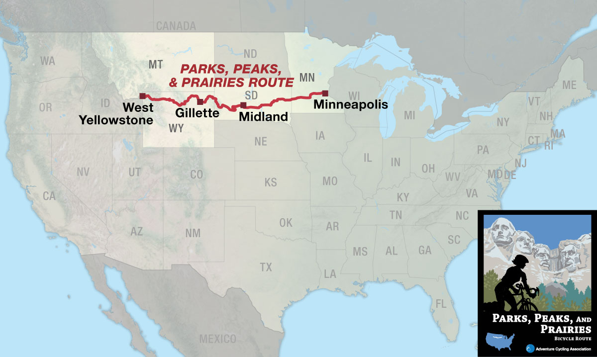
Wild places and wide open spaces
The Parks, Peaks, and Prairies Bicycle Route fulfills the request of so many cyclists visiting the ACA headquarters in Missoula for a northern connector between the TransAmerica Trail and the Northern Tier Bicycle Route — one that strings together the iconic American parks of Yellowstone, Devils Tower, Mt. Rushmore, Badlands, and the famous Black Hills of South Dakota.
But don’t expect the connection to come easily! Located nearly smack dab in the middle are the compact, yet formidable Black Hills. This small mountain range exhibits a network of rollercoasting, winding roads that can frequently rise to 10% grades for short durations. Many of these same roads are very popular for motorcyclists, especially in August for the world’s largest motorcycle rally centered in the nearby town of Sturgis. Roads and crowds notwithstanding, the Black Hills offers scenery and grandeur on a scale that may be surprising to the conventional out-of-state visitor.
The route begins in the gateway community of West Yellowstone, Montana and ends in the “City of Lakes” — Minneapolis, Minnesota. After riding 2.3 miles in Montana, the route enters Wyoming and Yellowstone National Park, which is renowned as America’s first national park. The route meanders past numerous geothermal hotspots, plunging waterfalls, and idyllic valleys teaming with wildlife.
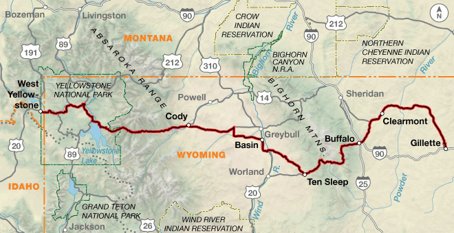
After Yellowstone, the route climbs east to Sylvan Pass where it crests the Absaroka Range. From there, it’s nearly 60 miles of downhill along the wild North Fork Shoshone River to the old west town of Cody, Wyoming. Here the route makes a departure from the mountains to enter the vast, windswept country of the Bighorn Basin. Towns are few and far between, and sagebrush and pronghorn abound. The small town of Basin anchors the route in this region, providing valuable services through this stretch of remote country.
Beyond the quaint outpost of Ten Sleep, the route climbs the beautiful Ten Sleep Canyon on its way over the Bighorn Mountains. The route tops out at Powder River Pass, elevation 9,675’, the highest point on the entire route. On the eastern flank of the Bighorns lies the city of Buffalo, the route’s gateway to the Great Plains. The wind in this region can be brutal, so be sure to be mentally prepared for some tough pedaling.
The city of Gillette, known as the “Energy Capital of the Nation”, marks the end of Section 1 of the route. About 30% of the nation’s coal is produced in nearby surface mines, which you’ll see as you enter and exit town.
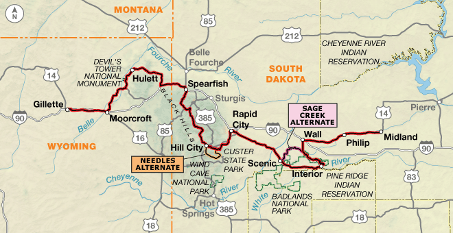
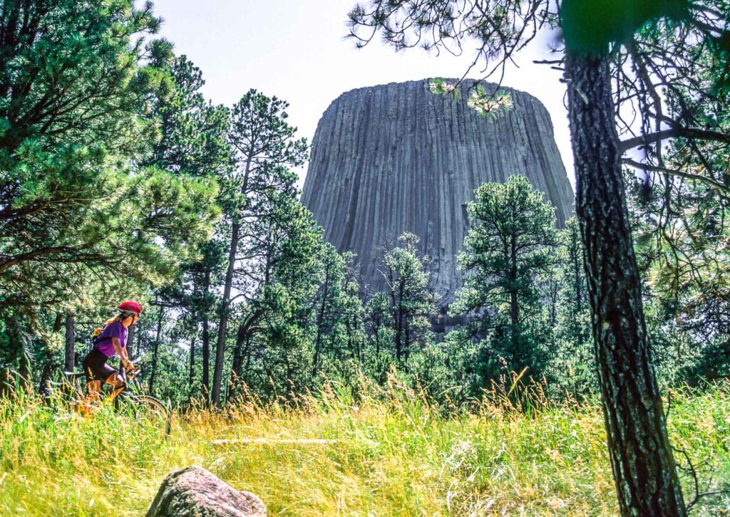
At Moorcroft, the route departs the I-90 corridor and meanders upstream roughly following the Belle Fourche River for over 40 miles. On clear days, the sharp pinnacle of Devils Tower National Monument comes into view long before you reach it, but when you do, a short side trip to the geologic curiosity is highly recommended. East of Hulett, the route leaves the Belle Fourche River, then tops a watershed divide in montane forest that serves as an appetizer to the strenuous climbs of the Black Hills that lie ahead.
The bike-friendly town of Spearfish greets the cyclist with a network of municipal bike routes, separated paths, and a sprawling city campground that is directly on route. The southern gateway to town is Spearfish Canyon, a scenic byway of pine-lined cliffs, waterfalls, and winding roads. This is where the Black Hills begin in earnest for the eastbound traveler. At the height of summer, recreational traffic levels increase on the twisting and rolling Black Hills highways, so stay sharp! Soon, due southwest of the deep-pit gold-mining town of Lead, relief comes as the route hops onto 34 miles of the George S. Mickelson Trail. South Dakota’s first rail-to-trail project, the Mickelson Trail is a separated, crushed limestone and gravel multi-use trail that generally maintains a 4% grade as it quietly passes through small towns, spruce/ponderosa forests, grassy meadows, and narrow valleys. The main route departs the trail in the lively town of Hill City, though an alternate route (not for the faint of heart) continues south before vaulting the cyclist over the jaw-dropping Needles Highway. Note that the alternate roads, besides being steep and excessively curvy, are affected by seasonal closures and often cannot be ridden prior to April. Whatever route is chosen, both lead to the historical — one might say kitschy — town of Keystone, at the doorstep of Mt. Rushmore National Monument.
Escaping the thrum of the Black Hills tourist mecca, the route remains steep and winding northeast to Rapid City, the largest city the route passes through until Minneapolis. Lazily pedal among the cottonwoods along Rapid Creek on the Rapid City Bike Path, which takes you on a tour of many of the city’s green spaces. Eastward, the route continues on relatively low-trafficked SR 44 and while the terrain mellows entering the grassland prairie, the wind can blow something fierce.
To the east, the Badlands “wall” rears up on the horizon as you approach the miniscule settlement of Scenic. Here the cyclist has more choices: continue on main route pavement to the Badlands National Park boundary and begin an assault of several passes along the popular Badlands Loop Rd., or veer north on the remote, unpaved Sage Creek Rd. to avoid the throng of visitors on main park roads. There are rewards, views, and challenges to be had either way, so choose wisely. At a high point next to the Pinnacles Overlook, the route finally, even gracefully, stops all its infernal winding and relaxes into a long straight descent into the world renowned town of Wall, home of the drug-store-turned-tourist-attraction non pareil — Wall Drug.
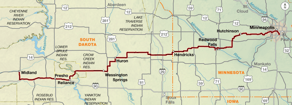
Turning east at Wall, the route continues a steady, almost meditative, navigation of long, linear highways with unencumbered views to the horizon on either side. The wind will, unfortunately, also continue to hound a cyclist through the expansive prairie grasslands. Along dipping and diving frontage roads, the route passes through a smattering of low-population towns offering a mixed-assortment of services to the wind-weary traveler.
After crossing the wide gape of the Missouri River on the Big Bend Dam Bridge, the route remains straight, but maneuvers the flatter county highways in a more zigzag fashion. Here the eastbound cyclist begins to see a slow change undergoing the surrounding countryside, as lakes dot the pastures and upland game birds splash from roadside bushes. The prairie pothole region affords many opportunities for an evening swim at lakeside campsites, and signals that distance is closing to the Minnesota state line, and ultimately, the City of Lakes. Agriculture and the renewable energy industry have a key foothold in this region, so expect to see evidence of both on your journey.
The terrain remains flat through southwestern Minnesota, with most elevation changes noticeable only when crossing or tracing major watercourses, such as the Minnesota, Crow, and Mississippi Rivers. Hutchinson, whose park system is the second oldest in the U.S. behind only Central Park in New York City, is an eastbound cyclist’s introduction to Minnesota’s world class network of separated bike trails. Starting with the Luce Line State Trail — the first in a long list of well-signed, often paved trails — the route delivers the sojourning rider easily and effortlessly into the heart of Minneapolis.
Photo by Dennis Coello
The route climbs over two major mountain passes, both in Wyoming. Sylvan Pass, at 8,524 feet, marks the beginning of the descent into the Bighorn Basin from the high elevation Yellowstone Plateau. Powder River Pass, 9,675 feet, is the route’s highest point at the crest of the Bighorn Mountains. The climb to Powder River Pass from either direction is one of the most significant climbs in the entire Adventure Cycling Route Network. The terrain becomes more rolling in the vast prairie between Buffalo and Moorcroft as it dips in and out of river and creek drainages. In the island mountain range of the Black Hills, expect similar elevation change but more tortuous roads than in the main Rockies. Short, frequent grades of 10% or greater can occur on these roads. For 34 miles, the climbing is smoothed by the steady railroad grade of the Mickelson Trail, though there are a few short, steep hills. The surface of the trail is crushed limestone and gravel, but ponding can occur in early season rain. The Needles Alternate between Hill City and Keystone offers some of the most strenuous climbing on the entire route. This optional route follows the outrageously scenic Needles Highway and Iron Mountain Road, two steep, narrow, and winding roads that are dotted with several tunnels and loops. Traffic can be heavy, but speeds are low and the pavement is in good shape. East of Rapid City, the Badlands of South Dakota offer more climbing in the form of an ascent of the “wall” along the paved main route or a backdoor, off-pavement grassland option along the Sage Creek Alternate. In heavy rain, the high clay-content alternate roads can turn into a thin gumbo capable of coating even the most well-lubed drivetrain. East of Wall, the route flattens out entering the main expanse of the Great Plains. The greatest form of elevation change here occurs where the route crosses or traverses major watercourses like the Missouri, Minnesota, and Mississippi Rivers. Expect localized climbs of hundreds of feet in these areas. Otherwise, the route follows county and state highways that undulate to the sweep of the prairie. The final 74 miles of the route assumes a level rail-trail grade on mostly paved surfaces, lasting through to the eastern terminus of the route in Fort Snelling State Park near the Minneapolis-St. Paul Airport.
| Parks Peaks and Prairies - Main Route | ||||
|---|---|---|---|---|
| Section | Distance | Elevation | Total Climb | Avg. Climb/mile |
| Total | 1287.7 miles | Minimum: 700 ft.Maximum:9,665 ft. | 53,465 ft. east bound59155 ft. west bound | 42 ft. per mi. east bound46 ft. per mi. west bound |
| 1 | 398.1 miles | Minimum: 3,600 ft.Maximum:9,665 ft. | 21,600 ft. east bound23650 ft. west bound | 54 ft. per mi. east bound59 ft. per mi. west bound |
| 2 | 379.7 miles | Minimum: 1,870 ft.Maximum:6230 ft. | 18,915 ft. east bound21550 ft. west bound | 50 ft. per mi. east bound57 ft. per mi. west bound |
| 3 | 509.9 miles | Minimum: 700 ft.Maximum:2,480 ft. | 12,950 ft. east bound13,955 ft. west bound | 25 ft. per mi. east bound27 ft. per mi. west bound |
| Parks Peaks and Prairies Alternates | ||||
|---|---|---|---|---|
| Section | Name | Distance | Total Climb | Avg. Climb/mile |
| Needles Alternate | 2 | 34.7 miles | 3,510 ft. east bound4,125 ft. west bound | 101 ft. per mi. east bound119 ft. per mi. west bound |
| Sage Creek Alternate | 2 | 25.1 miles | 1,305 ft. east bound990 ft. west bound | 52 ft. per mi. east bound39 ft. per mi. west bound |
The western half of this route can be ridden from May through October, but the route east of the Black Hills has a wider window of March through November. The high elevation areas of Yellowstone National Park, the Bighorn Mountains, and the Black Hills get heavy winter snow that can begin as early as September and linger into summer. The route in Yellowstone is closed in the winter. US 16 over Powder River Pass in the Bighorn Mountains is open year-round, only closing for major winter snowstorms. The route in the Black Hills is also open in the winter, except for the Needles Alternate which is generally open April to October.
Wind is an ever-present force across the entire route, and summer can bring high temperatures. There are often few trees available for shade and protection from the wind and sun. Do not expect to ride westerly tailwinds all the way east to the Twin Cities, since local conditions from rivers, mountain ranges, and other terrain features have a bigger effect on surface winds. Tornadoes occur in eastern South Dakota and western Minnesota. In the event of a fast-developing storm blackening the sky, seek shelter immediately.
Services options in Yellowstone and the Black Hills are plentiful due to the high volume of tourists, but along some stretches in Wyoming and South Dakota services become sparse and water sources are infrequent. The 95 miles between Buffalo and Gillette and the 70 miles between Rapid City and Interior have very limited services, so make sure to stock up.
The Sturgis Motorcycle Rally is held annually in Sturgis, South Dakota for ten days in early August. Any late summer bicycle tourist planning to ride in this area should carefully consider sharing the roads and services with droves of motorcyclists before setting out.
You may also wish to sign up with Warmshowers, a reciprocal hospitality site for bicycle travelers, for other overnight options.
Route Highlights
Parks, Peaks, and Prairies Highlights
- Yellowstone National Park, Section 1
- North Fork Shoshone River and Canyon, Section 1
- Buffalo Bill State Park, Section 1
- Cody, Wyoming, Section 1
- Ten Sleep Canyon, Section 1
- Powder River Pass and Bighorn Mountains, Section 1
- Keyhole State Park, Section 2
- Devils Tower National Monument, Section 2
- Vore Buffalo Jump, Section 2
- Black Hills National Forest, Section 2
- Spearfish Canyon, Section 2
- Mickelson Trail, Section 2
- Custer State Park, Section 2
- Mount Rushmore National Monument, Section 2
- Needles Alternate, Section 2
- Sylvan Lake, Section 2
- Black Hills Playhouse, Section 2
- Badlands National Park, Section 2
- Sage Creek Alternate, Section 2
- Buffalo Gap National Grassland, Section 2
- Wall Drug, Section 2
- Minuteman Missile National Historic Site, Section 2
- Big Bend Dam Bridge over the Missouri River, Section 3
- Shakespeare Garden and Anne Hathaway Cottage, Section 3
- Birch Coulee Battlefield, Section 3
- Oakwood Lakes State Park, Section 3
- Alexander Ramsey Park, Section 3
- Dakota Rail Trail, Section 3
- Carver Park Reserve, Section 3
- Minneapolis Regional Bike Trails, Section 3
- Minnehaha Falls, Section 3
- Historic Fort Snelling, Section 3
- Minnesota Valley National Wildlife Refuge, Section 3
More Route Resources
- Yellowstone National Park Current Conditions (Wyoming)
- Wyoming Road Conditions
- Yellowstone National Park Camping (Wyoming)
- Shoshone National Forest Camping (Wyoming)
- Gallatin Canyon Campgrounds (Wyoming)
- Gillette bike trails map (Wyoming)
- Devils Tower National Monument Current Conditions (Wyoming)
- South Dakota Road Conditions
- Spearfish Bike Map (South Dakota)
- Sturgis Motorcycle Rally (South Dakota)
- Mickelson Trail (South Dakota)
- Mount Rushmore National Memorial Current Conditions (South Dakota)
- Peter Norbeck Scenic Byway (Needles Alternate, South Dakota)
- Black Hills Playhouse (Needles Alternate, South Dakota)
- Custer State Park (South Dakota)
- Badlands National Park Current Conditions (South Dakota)
- Buffalo Gap National Grassland (South Dakota)
- No-Turn-Away Bicycle Camping Policies (Minnesota)
- Luce Line State Trail (Minnesota)
- Dakota Rail Trail (Minnesota)
- Lake Minnetonka Regional Trail (Minnesota)
- Cedar Lake Regional Trail (Minnesota)
- Midtown Greenway (Minnesota)
- Hennepin County Bike Route Interactive Map (Minnesota)
- USBR 45 and 45A (Minnesota)
- Historic Fort Snelling (Minnesota)
- Minneapolis and St. Paul Twin Cities bike map (Minnesota)
- Access to Minneapolis/St. Paul International Airport
- Minneapolis/St. Paul Metro Transit Light Rail
- How to Travel with your Bike on Amtrak
- Connect and share photos with other riders on Instagram: #acaPPP
Updates to Recently Released Maps
If you are planning a bike tour, be sure to get the most recent map updates and corrections for your route by selecting the route, and the appropriate section(s), from the drop-down menu below.
Over time maps become less useful because things change. Every year Adventure Cycling’s Routes and Mapping Department create map updates and corrections for every map in the Adventure Cycling Route Network, which now totals 52,047 miles. With the help of touring cyclists like you, we receive updates on routing, services, camping, and contact information. Until we can reprint the map with the new information, we verify the suggested changes and publish corrections and updates here on our website.
PLEASE NOTE: Covid has been particularly hard on the small businesses along our routes. While we do our best to keep the maps and these online updates current, you may encounter more closed businesses and longer stretches with limited or no services.
Refer to these updates for the most current information we have and submit reports of changes to the Route Feedback Form for the cyclists coming after you.
NOTE: Map updates and corrections only pertain to long term changes and updates. For short term road closures, please see the Adventure Cycling’s Routes Temporary Road Closures discussion in our Forums.