Northern Tier

Northern Tier Anacortes, WA to Bar Harbor, ME 11 Map Set GPX Data | Overview | Buy | Mobile App
1. Anacortes, WA to Sandpoint, ID Detail
2. Sandpoint, ID to Cut Bank, MT Detail
3. Cut Bank, MT to Dickinson, ND Detail
4. Dickinson, ND to Fargo, ND Detail
5. Fargo, ND to Walker, MN Detail
6. Walker, MN to Stillwater, MN Detail
7. Stillwater, MN to Muscatine, IA Detail
8. Muscatine, IA to Monroeville, IN Detail
9. Monroeville, IN to Orchard Park, NY Detail
10. Orchard Park, NY to Ticonderoga, NY Detail
11. Ticonderoga, NY to Bar Harbor, ME Detail

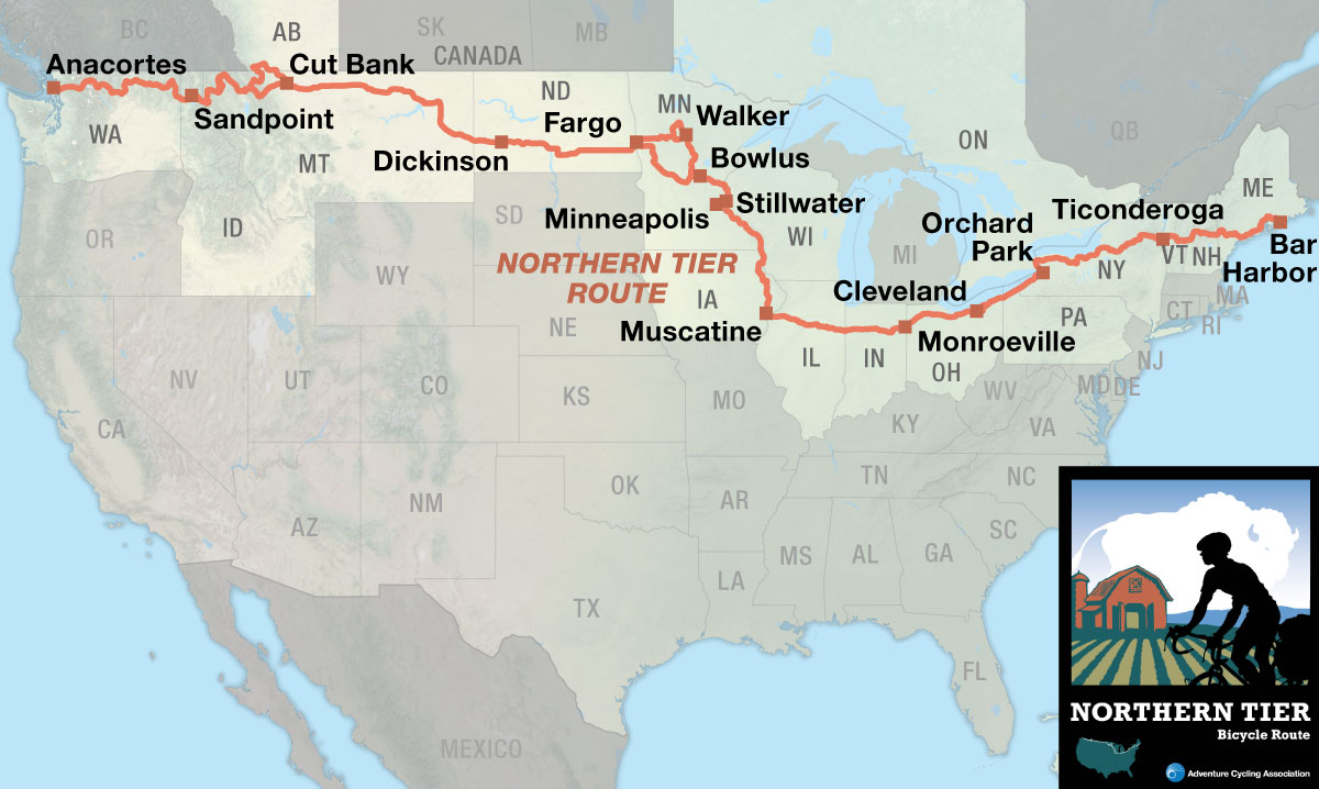
Cross the nation near the U.S. and Canada border.

The western end of the Northern Tier begins at sea level and offers large expanses of mountains, the Great Plains, and some beautiful farmland areas in between. The route can be ridden from late spring to late fall. Due to snow, State Highway 20 east of North Cascades National Park in Washington is only open through certain dates. The same is true for Going-to-the-Sun Road in Glacier National Park in Montana, which is usually closed until mid June. Even in the height of summer in July, cyclists must be prepared for cold nights and occasional snow in the higher elevations during storms. Due to changing local conditions, it is difficult to predict any major wind patterns, though tornadoes can be common. They slice across the heartland each year, generally heading north and east, and mostly occur in May and June in Wisconsin, Iowa and Illinois. The Midwest and Great Lakes summers can be hot, especially inland. Along the Great Lakes, breezes provide cooling and are sometimes a friend and sometimes a foe.

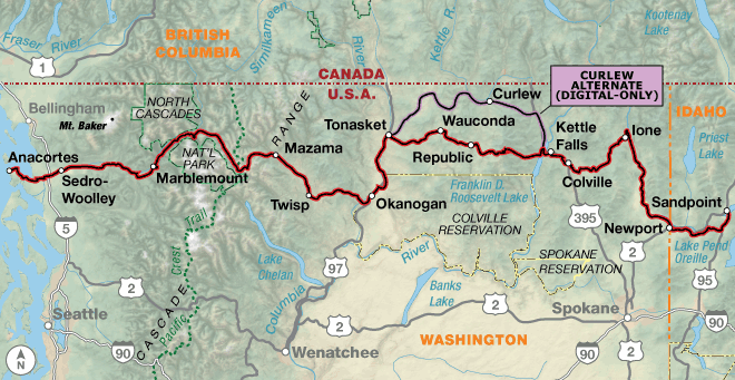
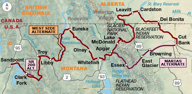
The Northern Tier begins in Anacortes, Washington, which is located on a peninsula in Puget Sound. Anacortes is also the jumping-off point for folks going to the San Juan Islands, a favorite cycling destination. At the start, the combination of lush forest and ocean feeds and moistens the soul. Heading eastward along the rushing Skagit River, you carry that feeling up to the top of Rainy and Washington passes in the Cascade Mountains. Descending to the east side of the Cascades brings you into the drier part of the state and the widely known orchard country of the Okanogan Valley. Leaving this valley, you’ll be climbing and descending several more passes full of ponderosa pines and finding many sleepy farming communities along the rivers you cross. The river valleys tend to run in a north-south direction across the northwestern part of the United States, and because the route travels west to east, you will be working your way up and down. There are plenty of towns, rivers, lakes, mountains and forests in eastern Washington, Idaho, and western Montana until you reach Cut Bank, on the eastern slope of the Rocky Mountains.

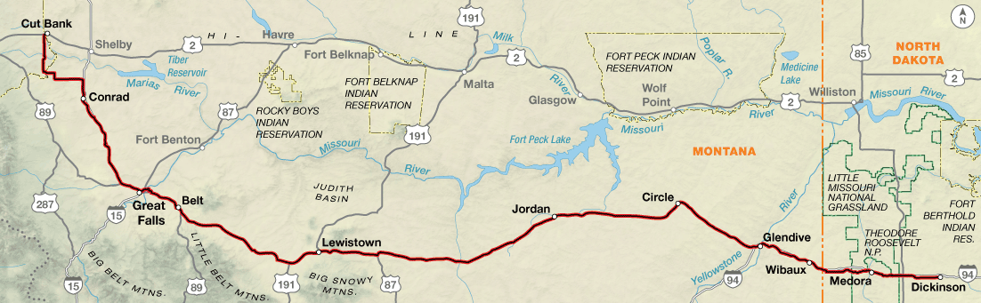
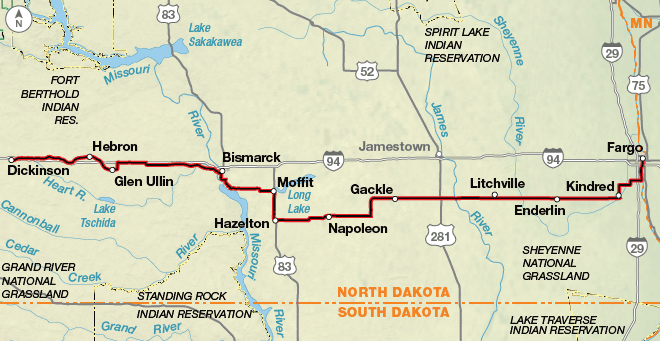
The spectacular Going-to-the-Sun Road in Glacier National Park is a hard climb but well worth it for the scenery. The route takes a jump into Canada to access Waterton Lakes National Park, and then you’ll head back into the States at Del Bonita, a little-used border crossing. Cut Bank is the beginning of the Great Plains, and from here on you’ll start praying for tailwinds. Supposedly, heading eastward, tailwinds predominate in the summer. Afternoon thundershowers are a constant companion out on the Plains. The plains of Montana eventually transform into the green rolling hills of western North Dakota. From Glendive, Montana, to Bismarck, North Dakota, the route follows the I-94 corridor, alternating between the interstate and parallel county roads.* Sunflowers are everywhere, and they become the crop of choice as the terrain flattens out in eastern North Dakota. Fargo is located on the banks of the Red River, on the border of North Dakota and Minnesota.

*Oil and gas development in the Bakken Oil Shale Field of western North Dakota and northeastern Montana prompted a change in routing in 2012 to avoid the area around Williston, North Dakota. Because many roads with minimal to no shoulders now have high levels of truck traffic, and are felt to be unsafe for bicyclists, the route was moved to go through southern North Dakota. For further information read our blog post on the issue.

Minnesota, Wisconsin, and Iowa stand out as some of the greenest and lushest of all the states along the route. From either direction, this greenery proves to be a relief from the giant plains to the west and acres of farmland to the east. You’ll learn a lot about the history of the Mississippi River as you follow it southward.

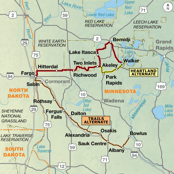
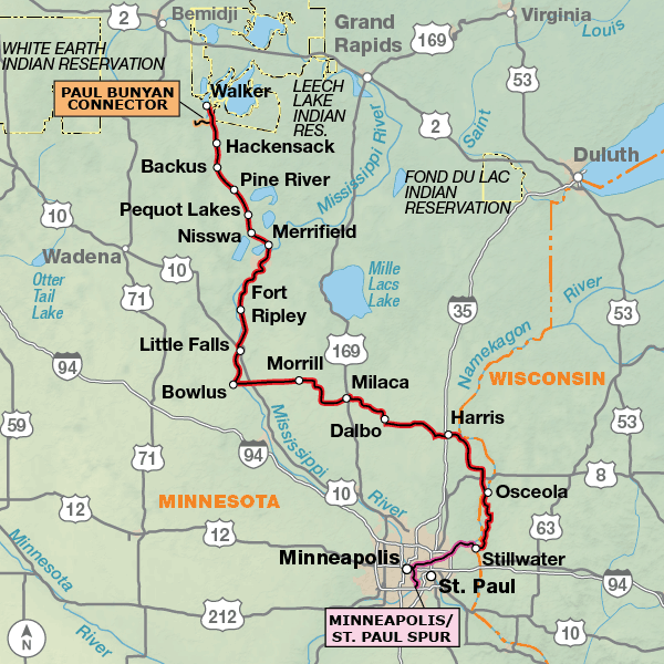
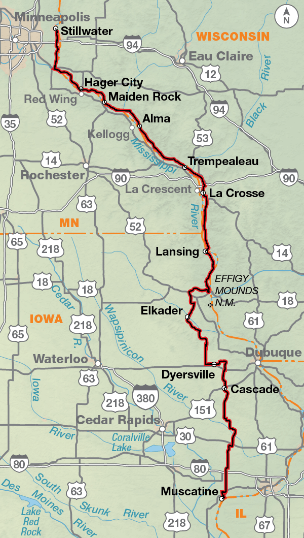
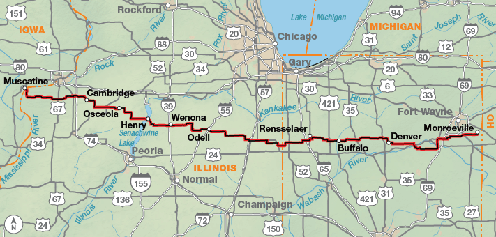
Heading east from Fargo and Moorhead in the Red River Valley, you begin to slowly leave the Great Plains. Lakes and hills become the standard scenery, and the resident mosquitos increase in number. The birthplace of the Mississippi River is in Lake Itasca State Park, in northern Minnesota. This area is so full of forests, lakes, and rivers that it draws many recreationalists during the summer months. The route utilizes many rail-trail facilities as you ride south until it heads east around the cities of Minneapolis, St. Paul, and surrounding towns. There is a spur into Minneapolis-St. Paul that ends with access to the airport. Along the St. Croix and Mississippi rivers, the towns are older and the buildings much more historic. At Prescott, Wisconsin, the St. Croix joins the Mississippi, and the route again follows it southward for 175 miles. You’ll ride the Great River State Park Trail, an old railroad bed surfaced with finely crushed limestone through Perrot State Park and the Upper Mississippi River National Wildlife Refuge. As you enter Iowa, you may think that the terrain is going to flatten out, but the hills continue after leaving the river. Small laid-back farm towns are abundant through Iowa. Muscatine is an old industrial town located on the Mississippi River.

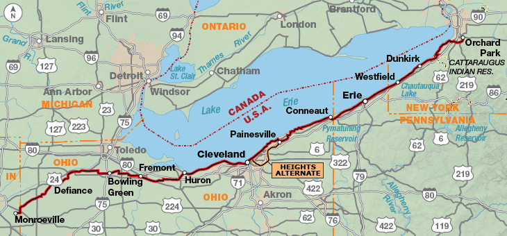
East of the river, the route traverses the large prairie farms of central Illinois and the smaller farms of Indiana and Ohio, eventually reaching the shore of Lake Erie at Huron, Ohio. Here a side trip can take you to nearby Cedar Point Amusement Park, which features the greatest number of the most pulse-raising roller coasters in the country. Or you can take a ferry to one or more of the Lake Erie islands and visit the area where Admiral Perry defeated the British fleet in the War of 1812. Heading through busy Cleveland, you’ll pass the Rock and Roll Hall of Fame, the Science Center and its IMAX theater, a retired Great Lakes iron ore freighter, and a World War II submarine.

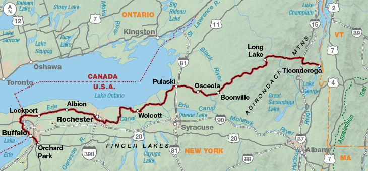
Along the lake shore in eastern Ohio and Pennsylvania, the route passes through small towns, where tourists flock to the shore during summer. In Erie, Pennsylvania, you can explore the miles of sand beach at Presque Isle State Park and the replica of the sailing ship Niagara, Admiral Perry’s flagship in the War of 1812 Battle of Lake Erie. Leaving Erie, the route enters the fruit and wine region of Pennsylvania and New York and hugs the relatively rural lake shore to the outskirts of Buffalo, New York. Views across Lake Erie of the Buffalo skyline and Canada usher the cyclist into the bustle of the southern end of the metropolis. In the suburbs to the Peace Bridge, ride carefully through the city streets. The route takes you to the lakefront Buffalo Naval and Military Park with World War II vessels open for visits.

After crossing the Peace Bridge into Canada you’ll follow one of the most scenic recreational trails in North America along the Niagara River to Niagara Falls. Take the cable car ride across the Whirlpool Rapids and visit the other attractions along the trail. Then you’ll cross back into the U.S., enjoying the view of the Niagara Gorge. Heading east, the route uses the Erie Canalway Trail for 86.5 miles along a waterway dripping with history. Take the time to explore the towns along the canal. At Palmyra, the route turns north to Lake Ontario, where it follows the lake shore to Sodus Bay, dips inland to Fulton, and then leaves the Great Lakes to cross the Adirondack Mountains and arrive at Ticonderoga on Lake Champlain. A visit to Fort Ticonderoga will give meaning to Revolutionary War history.

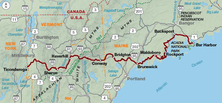
After a short ferry ride over the lake, you are in New England, cycling through Vermont farmland, forested hills, and picturesque villages. In New Hampshire, the route follows the Connecticut River, passing through the villages of Orford with its ridge houses and Haverhill, a classic New England village with its fenced village commons and old homes. The route crosses the White Mountains, the backbone of New Hampshire, on the famous Kancamagus Highway. Mt. Washington, noted for its fierce weather, is just a few miles north, and the Kancamagus shares some of its weather reputation. Be prepared, even in summer. Entering Maine, you’ll traverse forests and fields, arriving at Rockport on the coast. Allow time to savor the quintessential ambiance of the coastal towns. Before crossing the Penobscot River, stray off route to visit Ft. Knox, an exceptionally well-preserved unused Revolutionary War fort. Finally, don’t end your trip without cycling the gravel carriage paths of Acadia National Park and viewing a sunrise from atop Cadillac Mountain. The park is near the town of Bar Harbor, at the end of the route.

Photo by Chuck Haney

The route lets you warm up for about 100 miles before any prolonged climbing begins. There are four major passes in the first 300 miles, and Sherman Pass is the highest at 5,575 feet. The terrain then becomes rolling, the route following river valleys until you reach Glacier National Park. Logan Pass, on Going-to-the-Sun Road, is the last major climb in the Rocky Mountains. There’s a series of roller-coaster hills heading into Canada. Once you get about 20 miles east of the Rockies, you’re truly in Big Sky country with moderately flat countryside. The plains roll out through Montana and occasionally become hilly in western North Dakota, and then the route flattens out in eastern North Dakota and Minnesota.

In Wisconsin and Iowa the terrain is continuously rolling. Ask any Iowan if Iowa is flat, they will respond with a “No,” especially in the northeastern part of the state.

From the Mississippi River at Muscatine, Iowa to Palmyra, New York, the route is virtually flat. Illinois has some gently rolling prairie and is treeless except in towns. The trees increase in Indiana. East of Cleveland, Ohio, the route climbs to a low ridge for a few miles and then descends back to the lake shore until Buffalo, New York. From Buffalo to Palmyra, the route experiences only slight elevation changes at the locks along the Erie Canal. The mountains in New York, Vermont, and New Hampshire extend north and south, and the route travels east-west so the remainder of the route has a lot a variety — flat sections along river valleys and several challenging climbs. The Kancamagus Pass at 2,855 feet is the highest point on the eastern end of the Northern Tier Route.

Northern Tier - Main Route
Section Distance Elevation Total Climb Avg. Climb/mile
Total 4296.3 miles Minimum: 0 ft.
Maximum:6,650 ft.
174,315 ft. east bound
174,020 ft. west bound
41 ft. per mi. east bound
41 ft. per mi. west bound
1 454.9 miles Minimum: 0 ft.
Maximum:5,510 ft.
28,185 ft. east bound
26,170 ft. west bound
62 ft. per mi. east bound
58 ft. per mi. west bound
2 444.9 miles Minimum: 1,945 ft.
Maximum:6,650 ft.
26,565 ft. east bound
25,080 ft. west bound
60 ft. per mi. east bound
56 ft. per mi. west bound
3 567.3 miles Minimum: 2,045 ft.
Maximum:4,725 ft.
24,560 ft. east bound
25,860 ft. west bound
43 ft. per mi. east bound
46 ft. per mi. west bound
4 342.6 miles Minimum: 885 ft.
Maximum:2,570 ft.
3,635 ft. east bound
10,135 ft. west bound
11 ft. per mi. east bound
30 ft. per mi. west bound
5 174.8 miles Minimum: 875 ft.
Maximum:1,605 ft.
3,960 ft. east bound
3,585 ft. west bound
33 ft. per mi. east bound
21 ft. per mi. west bound
6 256.0 miles Minimum: 675 ft.
Maximum:1430 ft.
5,415 ft. east bound
6,175 ft. west bound
21 ft. per mi. east bound
24 ft. per mi. west bound
7 372.7 miles Minimum: 550 ft.
Maximum:1215 ft.
14,905 ft. east bound
14,875 ft. west bound
40 ft. per mi. east bound
40 ft. per mi. west bound
8 405.7 miles Minimum: 440 ft.
Maximum:870 ft.
7,085 ft. east bound
6,855 ft. west bound
17 ft. per mi. east bound
17 ft. per mi. west bound
9 411.3 miles Minimum: 570 ft.
Maximum:940 ft.
7,345 ft. east bound
7355 ft. west bound
18 ft. per mi. east bound
18 ft. per mi. west bound
10 426.5 miles Minimum: 240 ft.
Maximum:2200 ft.
19,230 ft. east bound
19865 ft. west bound
45 ft. per mi. east bound
47 ft. per mi. west bound
11 439.6 miles Minimum: 0 ft.
Maximum:2855 ft.
28,430 ft. east bound
28,065 ft. west bound
65 ft. per mi. east bound
64 ft. per mi. west bound
Northern Tier Alternates
Name Section Distance Total Climb Avg. Climb/mile
Curlew Alternate 1 102.5 miles 9,155 ft. east bound
8740 ft. west bound
89 ft. per mi. east bound
85 ft. per mi. west bound
West Side Alternate 2 45.9 miles 5,275 ft. east bound
4,930 ft. west bound
115 ft. per mi. east bound
107 ft. per mi. west bound
West Side Alternate 2 45.9 miles 5,275 ft. east bound
4,930 ft. west bound
115 ft. per mi. east bound
107 ft. per mi. west bound
Marias Alternate 2 102.9 miles 5,000 ft. east bound
4415 ft. west bound
49 ft. per mi. east bound
43 ft. per mi. west bound
SR 200 Alternate 2 11.5 miles 750 ft. east bound
590 ft. west bound
65 ft. per mi. east bound
51 ft. per mi. west bound
Trails Alternate 5 168.2 miles 2,680 ft. east bound
2390 ft. west bound
16 ft. per mi. east bound
14 ft. per mi. west bound
Heartland Alternate 5 39.3 miles 665 ft. east bound
800 ft. west bound
17 ft. per mi. east bound
20 ft. per mi. west bound
Paul Bunyan Connector 6 9 miles 555 ft. east bound
575 ft. west bound
62 ft. per mi. east bound
64 ft. per mi. west bound
Minneapolis/St. Paul Spur 6 35.5 miles 1,150 ft. east bound
995 ft. west bound
32 ft. per mi. east bound
28 ft. per mi. west bound
Heights Alternate 9 38.6 miles 1,570 ft. east bound
1,570 ft. west bound
41 ft. per mi. east bound
41 ft. per mi. west bound
Flats Alternate 9 1.1 miles 80 ft. east bound
80 ft. west bound
73 ft. per mi. east bound
73 ft. per mi. west bound

Services are generally good along this route. There is a 73-mile stretch of limited services between Cardston, Alberta, and Cut Bank, Montana. There are also some sporadic spots lacking services in central Montana, but nothing is farther apart than a day’s ride. The people of the towns across the plains of Montana and North Dakota are super generous and genuine. Camping in town parks is not uncommon. Only a few bike shops exist between Whitefish, Montana, and Bismarck, North Dakota. In the midwest, townsfolk are friendly. Campgrounds are reasonably plentiful, but there are a few gaps, and advanced planning is needed if you are camping.

Some campgrounds will charge a cyclist traveling alone less if they have hiker/biker sites, but often they will charge the price of a regular tent or RV site, and that can easily be $10-$40/night (higher in the east). The maps list churches that have opened their doors to cyclists, but they aren’t all that closely spaced. If you’re friendly and ask around, you can often get yourself invited to camp in a yard. Our routes sometimes go through national forests (moreso in the west) and you are allowed to camp anywhere on national forest land as long as you “pack it in, pack it out.” Many city parks are free to camp in.

You may also wish to sign up with Warmshowers, a reciprocal hospitality site for bicycle travelers, for other overnight options.

This route is best ridden in late spring to mid-fall (typically May to September). Due to heavy snow falls, State Route 20/North Cascades Highway in North Cascades National Park is usually closed mid-November to mid-April though the park remains open with limited access. For an opening date call the Park at (360) 856-5700. Going-to-the-Sun Road in Glacier National Park is usually closed until early to mid June and has limited hours for cyclists which is noted on the map. Call the Park for an opening date at (406) 888-7800. Some cyclists may want to do the eastern portion of this route during the colors of autumn. If you do, call ahead to verify campgrounds because many close after Labor Day. If staying indoors, make advance reservations.


Route Highlights

Northern Tier Highlights

  • North Cascades National Park, Section 1
  • Ross Lake National Recreation Area, Section 1
  • Glacier National Park, Section 2
  • Going-to-the-Sun Road, Section 2
  • Waterton Lakes National Park, Section 2
  • Lewis and Clark National Historic Trail Interpretive Center, Great Falls, Montana, Section 3
  • Theodore Roosevelt National Park, Section 3
  • Maah Daah Hey Trail, Section 3
  • Long Lake National Wildlife Refuge, Section 4
  • Sheyenne National Grassland, Section 4
  • Itasca State Park, Section 5
  • Heartland Alternate, Section 5
  • Minneapolis/St. Paul Spur, Section 6
  • Upper Mississippi River National Wildlife Refuge, Section 7
  • Effigy Mounds National Monument, Section 7
  • Field of Dreams, Section 7
  • Central Lowlands, Section 8
  • Cedar Point Amusement Park, Section 9
  • Rock and Roll Hall of Fame, Cleveland, Ohio, Section 9
  • Peace Bridge, Section 10
  • Niagara Falls, Section 10
  • Adirondack Park, Section 10
  • White Mountain National Forest, Section 11
  • Acadia National Park, Section 11

More Route Resources

RIDING CONDITIONS

Stretches of our route are concurrent with U.S. Bicycle Route (USBR) 10. Signs are installed in Washington and in Idaho. Be aware that signs can be damaged, stolen, or otherwise missing so you can never rely totally on following signs. For more information see advcy.link/wausbr and advcy.link/idusbr.

The Anacortes ferry terminal is the western terminus of the Northern Tier Route. This is for the convenience of those riders also going to the San Juan Islands – the most popular cycling spot in the U.S. The Anacortes area is hilly and there is a moderate amount of residential traffic. Follow the Tommy Thompson Trail, advcy.link/TTTrl, to avoid it. SR 20 heading east has shoulders and high levels of traffic. Burlington roads will be busy during commuting hours.

After crossing the Skagit River flats, the route starts a long, steady climb to the divide of the Cascade Mountains. Surfaces are generally good. Many stretches of SR 20 have no shoulders, but in most places the highway is wide. The route parallels SR 20 whenever possible where the traffic is light. The Cascade Trail runs 22.5 miles between Sedro-Woolley and Concrete and can be ridden as an alternate. The surface is crushed limestone with occasional paved sections. For more information see advcy.link/cascadetrl.

Due to heavy snowfalls, the North Cascades National Park is only open to through traffic on SR 20 between late April and late November. For exact dates, call the North Cascades Highway Hotline at 360-707-5055 or visit advcy.link/SR20mtnpasses for more details.

The descent from Washington Pass to Mazama is steep. You’ll be crossing a pass almost daily until reaching the Pend Oreille River valley.

Between Loup Loup Pass and Pleasant Valley West Rd., the SR 20 is steep with little shoulders. Four miles east of Aeneas Valley Rd. and 6 miles west of Wauconda, riders need to be extremely cautious. SR 20’s width decreases, shoulders disappear, and there is about 0.8-mi. of blind corners. SR 20 is busy with logging and mining traffic.

To avoid SR 20 between Tonasket and Kettle Falls, the 102.5-mi. Curlew Alternate is a digital file that is included in our GPX data and in the Northern Tier section 1 Bicycle Route Navigator (BRN) app. This routing is 22.7 miles longer than the main route. Traffic is light, with the exception of the 11 miles on U.S. 395. Services are minimal and there are no indoor accommodations available in Chesaw or Curlew. There are several campgrounds along the route. Plan to carry extra water with you.

Traffic will increase around towns and along the U.S. 395 corridor. East of Colville, SR 20 becomes narrow and is used by logging trucks. The descent to the Pend Oreille River is winding and steep. LeClerc Rd. has several rough stretches. Traffic is light to moderate until reaching U.S. 95 in Idaho, with the exception of busy Old Priest River Rd. U.S. 95 has shoulders and carries heavy commuting and tourist traffic. The Serenity Lee/Long Bridge Trail stretches between Sagle and Sandpoint over Lake Pend Oreille. For more information see advcy.link/SLeeLongBrtrl. There are high levels of traffic in Sandpoint.

All known Amtrak stations are listed on this map but not all stations provide bicycle service. Check if bicycle service is provided at both the starting and ending stations on your trip using the spreadsheet and other trip planning resources at advcy.link/amtrak.

CLIMATE

During fall, winter, and spring, conditions around Puget Sound are usually moist and misty, and temperatures are mild. Summer is relatively dry, and temperatures are seldom extreme.

Conditions in the Cascades and Rocky Mountains vary markedly with elevation. However, one generalization can be made: the western slopes are wetter. When moisture-laden winds from the Pacific are deflected upward – first by the Olympic Mountains, then the Cascades, and finally the Rockies – the air cools and releases virtually all its moisture. There is little precipitation left for the eastern slopes.

Mt. Baker, the most prominent peak on the Cascades west slope, receives an average of more than 100” of precipitation per year. In contrast, the town of Okanogan, which is roughly 100 miles east of Mt. Baker, receives a desert-like 12” of precipitation per year.

The climate of the high plateau between the Cascades and the Rockies is characterized by hot summers. May and June rains are followed by dry weather. The rain that falls on this high plain during the summer usually comes in short thunderstorms.

Updated: May 17, 2022

RIDING CONDITIONS

U.S. Bicycle Route (USBR) 10 and 110 are signed in Idaho. Our routing is not always concurrent with USBRs. For more information and maps see: advcy.link/idusbr. Be aware that signs can be damaged, stolen, or otherwise missing so you can never rely totally on following signs.

Visibility is poor on SR 200 east of Sandpoint and traffic will be heavy during commuting hours and weekends. Shoulder widths are variable so ride cautiously.

East of Clark Fork, the SR 200 Alternate is 3 miles shorter than the Main Route. SR 200 is narrow, winding and hilly with minimal to no shoulders along this stretch. Nearly three miles of the main route, on Clark Fork Rd., is in poor condition with deteriorating pavement and potholes (though conditions can change), but the pleasant scenery and lack of traffic are factors to consider when choosing which way to go.

In Montana, SR 56 offers grand scenery but poor riding; the road is narrow and curvy and a considerable number of logging and mining trucks use it. U.S. 2 between Troy and Libby has shoulders and moderate traffic.

East of Libby along Lake Koocanusa, the main route uses SR 37 which has good visibility and rolling terrain. The West Side Alternate is 5.9 miles longer, slightly hillier and has only one campground but it offers less traffic. Logging trucks may be encountered on either side of the lake.

Between Rexford and Eureka, the Tobacco River Memorial Trail follows a railroad bed for 7.4 miles. It is unpaved and relatively flat.

Leaving Eureka, the route parallels U.S. 93 for 14 miles. The Old Highway/Tobacco Rd. is unevenly maintained so expect some potholes and short gravel stretches. U.S. 93 has variable shoulder widths. It is also winding and narrow in parts, and the logging traffic makes sharp corners hazardous until you reach the outskirts of Whitefish. The route northeast of Columbia Falls includes a few miles of gravel, but avoids a narrow, dangerous stretch of U.S. 2 between Columbia Falls and Hungry Horse.

Near and in any national park cyclists will have to contend with higher traffic levels and RV drivers who are inexperienced. To avoid heavy traffic try to ride early in the day and make yourself and your bike visible.

In Glacier National Park, Going-to-the-Sun Rd. is narrow and has many blind corners. Be extra cautious of the tunnel and drainage grates on the west side of Logan Pass. Review and follow the bicycling restrictions listed on Map 24. For more information go to: www.nps.gov/glac/planyourvisit/bicycling.htm.

Going-to-the-Sun Rd. between West Glacier and Saint Mary is closed to all traffic from approximately Sept. 30 to June 15 due to heavy snow. The U.S. – Canada border crossing at Chief Mountain is closed from October through mid-May. Damage from wildfires in September 2017 linger in Waterton Lakes National Park. For an update on status go to: advcy.link/watertonnp.

If you wish to ride through Glacier National Park but not enter Canada, Duck Lake Rd./CR 464 is a good option from just south of Babb to Browning.

The Marias Alternate is 87.6 miles shorter than the main route. The climb is much easier than Going-to-the-Sun Rd. and the scenery is not as spectacular. Traffic is light to moderate. The road shoulder varies in width and increases between Browning and Cut Bank.

CLIMATE

The climate of the Rockies varies from valleys to peaks, from north to south slopes, and so forth. Short, violent thunderstorms are common during summer. Be prepared for sudden, drenching showers which can be accompanied by cool winds, and even snow. Total precipitation is light, however.

May and June showers are followed by dry weather. Summer can be hot in the northern Great Plains. Highs can occasionally go over 100 degrees. Spring and fall are pleasant, but fleeting.

Updated: Jan 2, 2019


RIDING CONDITIONS

The route begins in Cut Bank on the boundary of the Blackfeet Indian Reservation in the high windswept prairie comprising the eastern foothills of the Rocky Mountains. Heading south, SR 358 to Valier offers light (though fast) traffic on mostly long, straight roads that occasionally dive into a coulee or across a river or creek. As a result, prepare for overall rolling terrain with some limited sightlines and climbs/descents of up to a few hundred feet. There is very little tree cover to buffer the seemingly ever-present wind, which helps explain the windmills spotting ridges in the distance.

Traffic increases slightly on SR 44 east from Valier, but the more problematic feature for cyclists is centerline and shoulder rumblestrips that occur for nearly 14 miles of the straight, fast highway. Use caution here.

The I-15 frontage roads from north of Conrad to Vaughn can all be characterized thusly: smoothly paved, 70 mph speed limit, painted shoulder stripes, 10-11 ft travel lanes, and very low traffic. Agricultural traffic may be present and require proper attention, including watching for debris left on the road. And take care to heed livestock, as the route through this area traverses open range lands.

Between Great Falls and Lewistown, SR 200/US 87 generally has shoulder widths between 2-6 ft, though they may narrow closer to towns. The 1.2 mi. stretch of SR 331 into Belt allows access to vital services, but care should be taken on the blind curves and lack of rideable shoulders along the steep and narrow highway.

Around Lewistown US 87/SR 200 is in good condition and though the shoulder width will vary, traffic volume is light. Heading east from Lewistown, you’ll be crossing the Judith Mountains. US 87/SR 200 is narrow and the grassy shoulder areas frequently drop off. Services are sporadic between Lewistown and Jordan. Stock up on supplies in Jordan since the next reliable services are 66 miles away in Circle.

From Glendive to Dickinson, North Dakota, the route follows the I-94 freeway corridor. Service stops and post offices are more frequent, but still can have unreliable food selections and business hours. If you are choosing a mail stop on this section pick a larger town for delivery. The route here alternates between wide-shouldered I-94 and quiet Old Hwy 10. This highway has very rough pavement occasionally, so be careful, but it makes a scenic and worthwhile respite from the interstate.

East of Medora, there is an oil dump in Fryeburg. You will encounter a considerable amount of truck traffic on Old Hwy. 10 between Fryburg and Belfield.

Recent oil and gas development in the Bakken Oil Shale Field of western North Dakota and northeastern Montana prompted a change in routing in 2012 to avoid the area around Williston, North Dakota. Because many roads with minimal to no shoulders now have high levels of truck traffic and are felt to be unsafe for bicyclists, Adventure Cycling changed the route to go through southern North Dakota.

All known Amtrak stations are listed on this map but not all stations provide bicycle service. Check if bicycle service is provided at both the starting and ending stations on your trip using the spreadsheet and other trip planning resources at advcy.link/amtrak.

CLIMATE

In the agricultural communities along the route, people are extremely weather conscious. Since the year’s wheat crop or the season’s cattle forage depends upon mere inches of precipitation for its survival, there is little margin to accommodate nature’s natural fluctuations between abundance of moisture and drought.

The late Montana historian K. Ross Toole wrote, “Neither drought nor rain is ‘normal’ on the arid plains. They are the outer reaches of the pendulum’s swing.”

The climate varies notably, both from year to year, and from season to season. The temperature rises rapidly in the spring, hits a short, hot summer, then beginning in September, falls rapidly to a long, cold, dry winter.

Less than 17 inches of precipitation is not at all unusual. Fortunately, most of the rainfall comes during growing season, when the crops need it most. May and June rains are followed by long, dry days, ideal for ripening and harvesting grain. The summer rain on the plains fall mainly in the form of short-lived, violent thunderstorms.

Updated: Jun 8, 2020


RIDING CONDITIONS

Between Dickinson and Bismarck the route follows the I-94 corridor and services are fairly well-distributed. Be careful on Old Hwy. 10 east of Dickinson. It has an increasing amount of truck traffic and no shoulder so ride cautiously.

Between Glen Ullin and New Salem cyclists can ride 11.8 miles of gravel CR 139 to avoid the 12.5-mile stretch on I-94. Traffic on CR 139 is light, though it has a few hills that will restrict sight distance. It may be paved in the future; ask locals for updated information.

The route through Bismarck, the capital city, mostly uses bike paths. It is still best to avoid riding during rush hours.

Between Bismarck and Fargo towns are very small and widely spaced. The route follows county roads and state highways that carry very little traffic. Road surfaces are usually good with intermittent shoulders. Carry extra food and water.

In broad terms, the terrain is a vast, open plain that slopes downward from the Rocky Mountains to the Mississippi River. The elevation falls from about 1,800 feet at Bismarck to less than 900 feet at Fargo, located at the North Dakota/Minnesota state line.

Local relief is very gentle, with the exception of a few hills across river breaks. Be sure to enjoy the shade and water at Little Yellowstone Park on the Sheyenne River west of Enderlin. Highway shoulders are intermittent, and particularly lacking between Enderlin and Kindred. Cross the railroad tracks carefully east of Enderlin since they are at a sharp angle to the highway.

All known Amtrak stations are listed on this map but not all stations provide bicycle service. Check if bicycle service is provided at both the starting and ending stations on your trip using the spreadsheet and other trip planning resources at advcy.link/amtrak.

CLIMATE

This section of the route passes through a transitional zone between the arid west and the humid east.

The western half of North Dakota partakes of the light rainfall and dry air of the Great Plains. Rainfall, although sparse and unreliable, fortunately falls during the growing season, when plants need it the most.

The eastern half of North Dakota is in the semi-arid extension of the cold, humid continental zone that runs from Maine to Manitoba. Rainfall is more reliable here. In fact, the Red River valley, on the far eastern edge of North Dakota, receives enough precipitation to be considered an adjunct of the corn belt.

Overall, North Dakota’s climate varies markedly from season to season, as well as from year to year. Temperatures rise rapidly in the spring, peak during the short, hot summer, then – beginning in September – drop rapidly for a cold, dry winter.

Shifting winds are, in large part, responsible for the rapid changes in temperature. Warm air from the Gulf of Mexico cooks up summer heat waves and moderates winter temperatures. One story is that a South Dakotan, proud of his state’s warmer climate, once proposed that his state be named “Cota” and North Dakota be called “Over-Cota.”

Updated: Jun 8, 2020


RIDING CONDITIONS

Many camping and lodging options listed in the Service Directory are vacation resorts that experience a high season during the summer. Rates increase dramatically and accommodation is only offered on an extended basis, if it is available at all. Calling in advance for a reservation is highly recommended for any resort service or accommodation.

Dispersed camping is allowed in state forests in Minnesota. For more information on dispersed camping and a map of Minnesota state forests see advcy.link/mndnrcamp and advcy.link/mndnrmap.

U.S. Bicycle Route (USBR) 45, 45A, and 20 have been designated in Minnesota. Portions of our route run concurrent with them. For more information and maps see advcy.link/mnusbr.

The roads on this section, with the exception of U.S. 71 south of Lake Itasca, are quiet rural roads with no shoulders. These roads generally have good to excellent surfaces. U.S. 71 has shoulders and will carry more traffic. The trails on both the main route and alternates are all paved.

Through western and central Minnesota the route passes through slightly rolling terrain. Lakes and the resident mosquitos increase in number. Just north of Lake Itasca the hills grow in stature, many of them providing scenic views of the agricultural countryside.

The route through Itasca State Park, the birthplace of the Mississippi River, is a visual treat. Main Park Dr. gets heavy use from recreational vehicles during the summer. The speed limit in the park is 30 mph. Wilderness Drive, an optional ten-mile, one-way north-to-south loop should not be missed if your schedule allows.

Traffic increases in Bemidji but you will be on roads for only a short distance. A map of Bemidji’s path system can be found here: advcy.link/bemidjimap. The route leaves Bemidji heading south using 30.3 miles of the Paul Bunyan State Trail. This area is rich in history, having been inhabited for centuries before French explorers arrived. For more information see: advcy.link/mnpaulbsttrl.

Beginning in Moorhead, the 168.2-mile Trails Alternate goes to Bowlus (which is located on the main route on section #6). The alternate is 103.7 miles shorter, but has many of the same characteristics as the main route. The alternate begins on a mix of paved bike trails and residential roads along the river corridor in Moorhead MN. A map of Moorhead’s bike trails can be found here: advcy.link/moorheadmap. The alternate includes 107 miles of converted rail-trails on the Central Lakes, Lake Wobegon, Lake Wobegon Spur and Soo Line state and regional trails. You’ll be traveling through woodlands, wetlands, grasslands, and farming and recreational countryside. For more information see: advcy.link/mncentlakesttrl and advcy.link/mnlakewotrl and advcy.link/mnsoolinetrl.

The 39.3-mile Heartland Alternate decreases the distance between Two Inlets and Walker by 38.1 miles. It uses 28.5 miles of the Heartland State Trail. Views of lakes, rivers and streams are numerous, and many are accessible. The trail passes through northern hardwood forests and stands of pine, as well as spruce fir forests. For more information see: advcy.link/mnheartsttrl.

All known Amtrak stations are listed on this map but not all stations provide bicycle service. Check if bicycle service is provided at both the starting and ending stations on your trip using the spreadsheet and other trip planning resources at advcy.link/amtrak.

CLIMATE

Central Minnesota lies in the Continental climate zone. Occasional periods of prolonged heat occur during the summer months. Pacific Ocean air masses moving in from the Rocky Mountains have a moderating effect on the region’s summer temperatures. Thunderstorms happen frequently along the route during summer afternoons.

Tornadoes are common; the yearly average is 17 twisters, most of which occur in June and July. Most tornadoes usually move from the southwest to the northeast, at the rate of approximately 25 to 40 miles per hour. Their path of travel can be erratic. If you see one on the horizon seek shelter belowground at a farmhouse, if at all possible. If not, find a ditch or low spot and wait out the storm.

Climate information from Weather America, A Thirty Year Summary of Statistical Weather Data and Rankings, 2001, 2nd edition, Grey House Publishing, Millerton, NY.

Updated: Jun 8, 2023


RIDING CONDITIONS

Many camping and lodging options listed in the Service Directory are vacation resorts that experience a high season during the summer. Rates increase dramatically and accommodation is only offered on an extended basis, if it is available at all. Calling in advance for a reservation is highly recommended for any resort service or accommodation.

On this map section, you will be riding on paved state trails and two-lane roads with varying shoulder widths. The countryside is open with rolling wetlands, dense stands of trees, and shrubs along the lakes. Services are frequent. The small towns along the state trails cater to traveling cyclists.

U.S. Bicycle Route (USBR) 45 has been designated in Minnesota, often on trails. Portions of our route run concurrent with it. For more information and maps see advcy.link/mnusbr45.

In Walker, The Heartland Alternate (from section 5) comes in from the east. The Paul Bunyan Connector is 9 miles long and connects the main route to the Heartland State Trail for a longer (by 10 miles) but more scenic route leaving Walker. For more information about the Paul Bunyan and Heartland State Trails see: advcy.link/mnstatetrails. In Bowlus, the Trails Alternate (from section 5) rejoins the main route. For more information on the Soo Line Trail see: advcy.link/mnsoolinetrl.

Just south of Dalbo, the route turns east and traverses slightly rolling countryside through farmland to Osceola, Wisconsin. The roads are two-lanes with no shoulders, and have low to moderate traffic.

Just east of Osceola, you’ll be on SR 95 for one mile. SR 95 carries a large amount of summer recreational traffic. After crossing the St. Croix River into Osceola, the route remains on the east side of the river to avoid the traffic on SR 95. There is a steep climb from the river into Osceola.

In Wisconsin, riding near the rivers means hillier country along the bluffs. You’ll be mostly on two-lane roads with no shoulders. There is a steep descent and stop sign at SR 64 before the St. Croix River, and a steep ascent after the bridge into Stillwater, Minnesota. This bridge crossing is narrow and heavily traveled, so ride cautiously.

A spur route is shown from Minneapolis/St. Paul International Airport to Stillwater. It is 35.5 miles long. In Minneapolis the route uses several bike paths through state and city parks situated along the Mississippi River. Ride slowly and be on the lookout for pedestrians, runners, and skaters. In Stillwater, Brown’s Creek State Trail connects to the Gateway State Trail, which is built on the former Soo Line Railway grade and passes through urban areas and parks. As you head away from the twin cities, it traverses wetlands, fields, and wooded countryside. For more information on Brown’s Creek and Gateway State Trails see: advcy.link/mnstatetrails. Contact advcy.link/twinctybikemap for a Twin Cities Bike Map.

On Map 80, if you’re interested in riding more of Minnesota’s trail system, you can ride south out of Harris on CR 30 to connect with the Sunrise Prairie and Hardwood Creek Trails. Then you can take CR 4 and CR 12 into Stillwater . For more information see: advcy.link/sunprietrl and advcy.link/hardwdtrl.

CLIMATE

Generally, 80 percent or more of thunderstorms occur from May through September in Minnesota. Damaging local windstorms, tornadoes, hail and heavy rains happen with the stronger and more well-developed storms. Watch the horizon and if you see a storm coming, seek shelter.

Updated: Oct 19, 2018


RIDING CONDITIONS

In general, you’ll encounter either hills or long rolling grades along this section, with the exception of flat terrrain north of Muscatine, Iowa. The route avoids most of the heavily trafficked areas along the Mississippi, although there are a few stretches that demand caution. Traffic increases wherever the route crosses rivers.

U.S. Bicycle Route (USBR) 45 and 45A have been designated in Minnesota, often on trails. For more information and maps see: advcy.link/mnusbr.

All known Amtrak stations are listed on this map but not all stations provide bicycle service. Check if bicycle service is provided at both the starting and ending stations on your trip using the spreadsheet and other trip planning resources at advcy.link/amtrak.

From Stillwater south to Afton you’ll be riding through a growing residential area on narrow county roads. At Prescott, the route crosses the St. Croix River into Wisconsin to follow the Mississippi River’s east bank. The Prescott bridge is narrow and heavily travelled. There is a walkway you can use on the south side. SR 35 has wide paved shoulders and traffic levels are low. It travels through rural farmland and forest, passing through several small communites along the way. The largers towns of Red Wing, Wabasha, and Winona are all accesible for more services via wide bridges across the river into Minnesota.

Before entering the urban area of Onalaska and La Crosse, the route exits SR 35 onto 2.8 miles of dirt roads through the swampy backwaters of Trempealeau Wildlife Refuge. You’ll ride onto the Great River State Park Trail for 19.2 miles, an old railroad bed surfaced with finely crushed limestone through Perrot State Park and the Upper Mississippi River National Wildlife Refuge. The trail has many trestle crossings along isolated prairie and wetlands. A user fee is charged.

To see maps of the Great River State Park Trail and other maps for cycling in Wisconsin, see advcy.link/wibikemaps.

Traffic increases near the La Crosse-Onalaska metro area, and then the route returns to SR 35 with traffic decreasing as you go further south. SR 82 across the Mississippi River floodplain is narrow with several pinch points over water crossings. The final bridge before Lansing is inclined and narrow with a steel grid deck, but has a low speed limit. It may be slippery when wet, so ride with extreme caution.

From Lansing to Colesburg traffic is light. The country is very hilly, so roads have short sight distances and are roughly surfaced.

Between Dyersville and Farley you can choose to ride the Heritage Trail. It is built on an old railroad bed. The surface is unpaved but compacted and a user fee is required. South from Farley you’ll use highway and county roads with no shoulders as the terrain flattens out. Traffic increases around Muscatine. Stay on the bike trail to access the center of town for services.

CLIMATE

Southeastern Minnesota and northeastern Iowa may experience higher summer temperatures when warm air pushes north from the Gulf of Mexico. Thunderstorms happen frequently during the afternoons.

Tornadoes are also common in Iowa. The yearly average is 20 twisters, most of which occur in May and June. These funnel clouds slice across the heartland each year, generally heading north and east. Their path of travel can be erratic. If you see one on the horizon seek shelter belowground at a farmhouse, if at all possible. If not, find a ditch or low spot and wait out the storm.

Updated: Apr 7, 2020


RIDING CONDITIONS

Terrain in the Central Lowlands, where this section is located, is flat to gently rolling. The elevation rises less than 500 feet between the Mississippi River on the Iowa/Illinois border and Ohio. One of the few places where hills are noticeable is in east-central Indiana, around the Salamonie River and Mt. Hope Recreation Areas.

Many of the rural roads in both Illinois and Indiana will change names often but you will essentially be following the same road for reasonably long stretches at a time.

Leaving busy Muscatine you cross the Mississippi River into rural Illinois and ride onto the floodplain along less-traveled roads. Flat land usually means straight highways, and that is the case here. There are some exceptions though, especially where the route crosses a river or stream. You’ll have great visibility ahead and behind. The tall corn, however, can screen everything to the sides. Listen for vehicles approaching from the fields; some farmers don’t stop when they drive onto the roads. The corn can also hide road signs when it gets high.

Services between towns are minimal, so plan your day’s ride accordingly, and carry extra water with you.

All the county roads and highways have good to very good surfaces. The county roads are virtually unused, except by locals. Traffic increases in early July during the winter wheat harvest, and then in late September during the corn and bean harvest. If you are in truck garden country, such as central and eastern Indiana, you can expect slightly more traffic throughout the summer.

U.S. Bicycle Route (USBR) 35 and 35A have been designated in Indiana. A brief portion of our route runs concurrent with USBR 35. For more information and maps see advcy.link/inusbr.

Use caution on SR 16 east of Buffalo, since many trucks use this road to get to a landfill. Roads around the Tippecanoe River and the Salamonie Lake State Recreation Area get busier when the weather gets warmer, especially on weekends.

Between Zanesville and Monroeville, Yoder Rd. and Hoagland Rd. are narrow, two-lane roads with no shoulder, so be cautious when riding this stretch.

CLIMATE

The Central Lowlands is a greenhouse in the summer and an icebox in the winter. Total annual precipitation is 30-40 inches, about half of which falls in torrential summer thunderstorms.

The real glamour, though, is the Midwest twister, the tornado that took Dorothy and Toto to Oz. These funnel clouds slice across the heartland each year, generally heading north and east. In March the tornadoes are in Kentucky, in May in Illinois, and in June in Wisconsin. Their path of travel can be erratic. If you see one on the horizon seek shelter belowground at a farmhouse, if at all possible. If not, find a ditch or low spot and wait out the storm.

Updated: Jul 18, 2019


RIDING CONDITIONS

You will encounter a substantial change in traffic in this section when the route traverses the city of Cleveland and its suburbs. Cyclists should have some familiarity with urban riding. Once you reach Lake Erie the route passes through many interesting cultural, historic, and scenic features, and you are encouraged to research the route beforehand to maximize your enjoyment. Due to space limitations, we can only mention a small portion of what is available.

U.S. Bicycle Route (USBR) 30 and 230 have been designated in Ohio. Much of our routing is concurrent. For more information and maps see: advcy.link/ohusbr. In Pennsylvania, USBR 30 is designated and also follows signed BicyclePA Z. For more information and maps see: advcy.link/pausbr30.

The route in Ohio generally uses either secondary highways (moderately wide with low traffic) or county roads (two lanes with no shoulders), with the exception of Cleveland and its suburbs where you’ll use city streets or bike paths. The county roads you’ll use have different designations signed “CR” (for county) or “TR” (for township).

From the Ohio border to Grand Rapids you’ll follow creek and river corridors. The steady residential traffic on the southern side of Defiance calls for some defensive urban riding. This portion of Ohio is mainly rural, though towns are frequent.

At Huron the route begins to parallel the Lake Erie shoreline. You can access Cedar Point Amusement Park, the Lake Erie islands, and Canada from Sandusky, which is 8 miles west of Huron. Be sure to use the sidewalk bridges in both Huron and Lorain when crossing the rivers. The bridge decks have dangerous grate sections in mid-span.

Heading eastward the route becomes more residential. Most of the traffic is local and several communities have designated bikeways, so cyclists are a familiar sight. Note that there is no camping available between the campground south of Vermilion and the campground east of Painesville.

US 6 between Sandusky and Avon Lake carries heavy traffic and challenging riding conditions. Parts of US 6 may be rumble stripped with variable shoulder conditions. It may best to ride this stretch outside of commuting hours. Ride with caution on Lake Rd. and W. Lake Ave. in western Cuyahoga County. The roads are narrow and have tilted concrete gutters with drainage grates. Also ride with caution when crossing the Rocky River bridge. There is no shoulder on the bridge and high traffic. Traffic continues to increase near Cleveland, so ride defensively and carefully.

The signed Cleveland Lakefront Bikeway begins west of Bratenahl and goes to Euclid on streets and separate paths. From Bratenahl eastward to Painesville the route is flat and follows heavily-trafficked SR 283. Be cautious of variable road conditions between Cleveland and Eastlake. You’ll be going through mainly residential areas and a series of towns. As you travel farther away from Cleveland the route becomes rural. For an interactive map of recreation sites in Cleveland see: advcy.link/clevemap.

You’ll again join the lakeshore beginning at Geneva-on-the-Lake, a busy resort town. SR 531 has minimal to no shoulders, but carries only local traffic. Ashtabula and Conneaut are easy towns to cycle though. Expect heavier tourist traffic along the lake on summer weekends.

Across Pennsylvania and into New York the route follows a signed bike route using SR 5. Many services are located in the towns on US 20 which parallels SR 5. Traffic increases both west and east of Erie, but the route in town is mainly on a separate paved bike path.

A fruit and wine region begins east of Erie and stretches past Silver Creek, New York. As you near the end of this map section, traffic will increase as you ride on a combination of county roads, town streets, and state highways.

The 38.6-mile Heights Alternate through eastern Cleveland to Painesville gives the cyclist access to more parks, museums, gardens, and stately homes. On the Alternate, you will ride on the Harrison Dillard Bikeway where it parallels Martin Luther King Jr. Blvd. More information on the bikeway may be found at: advcy.link/hdbkwy. The alternate is 10 miles longer than the main route and is hillier, so will take longer to ride. It has few services and is mainly residential in nature. Ride cautiously on River Rd./SR 174. There are short sight distances due to many curves.

All known Amtrak stations are listed on this map but not all stations provide bicycle service. Check if bicycle service is provided at both the starting and ending stations on your trip using the spreadsheet and other trip planning resources at advcy.link/amtrak.

CLIMATE

Most of the weather of Ohio, western Pennsylvania, and western New York originates in the interior of the continent, then rides over this area on the prevailing winds. The result is a climate with “moderate extremes” of heat and cold, dryness and wetness.

Lake Erie, like any large body of water, helps moderate the climate of the surrounding area. The result is a climate uniquely suited to frost-sensitive fruit trees and vines.

Updated: Jun 2, 2023


RIDING CONDITIONS

Almost all of the state and U.S. highways and many county roads in New York have wide paved shoulders, so riding will be fairly pleasant. From Orchard Park northward into downtown Buffalo the route is fairly direct; expect traffic and urban conditions and ride defensively. A nicely paved but poorly signed bike path extends from near the Buffalo Naval Park to the Peace Bridge, which takes you into Canada. The Peace Bridge is an easy crossing on the bridge sidewalks, but please follow the instructions carefully when approaching the bridge from either direction. For route information bypassing Canada please contact the New York DOT at 716-847-3246 or see: www.dot.ny.gov/bicycle.

The 27-mile ride through Canada uses the Niagara River Recreation Trail and short portions of the Niagara Parkway along the scenic Niagara River. Use the Trail wherever possible for safety. The route near the Falls is extremely busy in summer, but all traffic and pedestrians are moving slowly, so you will be also. Walk your bike if necessary in the Falls area, and remember to lock your bike if leaving it. You will cross back into New York on the Lewiston-Queenston Bridge. Follow the instructions carefully when approaching the bridge from either direction. Since the bridge was rebuilt in 2006 bicycles now cross in the car lanes. We suggest you check with a bridge or customs official before riding onto it for instructions.

At Lockport, you will begin riding on a 86.5-mile section of the Erie Canalway Trail. The service road entrance/exit may be barricaded but you can get around it with care. The trail surface varies from smooth crushed limestone, smooth gravel screenings, and doubletrack, to pavement. As long as you have good touring tires these surfaces are smooth enough for road bikes, but you can also use SR 31/NY Bike Route 5 which parallels the Canal. You won’t be able to go as fast on the Canal Trail as you would on pavement, but it offers a nice change from riding in traffic. The towns along the Canal are rich in history and services are located in the towns. Be careful when crossing the occasional grated bridge decks to reach these towns. Along the Trail there is one short section east of Brockport that is rougher. Portions of the Trail are paved around Rochester. In Rochester, remember to follow the “Canal Trail” signs and the large yellow arrows on the path, not the bike path along the river.

Note that there are no established campgrounds between Middleport and Pultneyville. In Middleport, Holley, Macedon and Palmyra camping is allowed at locks along the canal; see the Boater-Hiker-Biker campsites listed in the Service Directory.

The countryside east of Rochester is more isolated. At Palmyra, the route leaves the Erie Canal and heads northward to the shore of Lake Ontario. In Fulton, beware of the tire-catching storm drains set in the roadways.

The terrain becomes hilly east of Lake Ontario and mountainous east of Old Forge. The route follows generally good roads through the Adirondack Mountains and the Adirondack Park Preserve. There can be heavy recreational traffic on the weekends during summer months, so try to either ride on weekdays or early on weekends through this region. When you reach the Schroon River valley heading south River Rd. provides a break from the poor condition of the pavement on U.S. 9.

NOTE: If cycling this route to enjoy the fall colors, we recommend you call ahead to campgrounds to verify that they are open. Many close after Labor Day.

CLIMATE

For the most part, weather in upstate New York originates inland over the continent. Cold, dry air comes from the northern interior and warm, humid air from the south. At times, however, air from the north Atlantic intrudes, causing wetter weather, warm and humid in the summer, cloudy and damp in the winter.

Because of differences in terrain and latitude, there is considerable variation in climate from one region to the other. The Adirondacks in the northeastern third of the state receive the most precipitation, including more snowfall than anywhere east of the Rockies.

Lake Ontario acts as a giant thermal mass, moderating temperatures in the lake shore area. The Appalachian uplands in central New York and the Adirondacks have cool, wet summers.

Updated: Jun 25, 2018


RIDING CONDITIONS

Vermont highways are well-signed and, with few exceptions, maintained and surfaced in average condition. Be prepared for some steep climbing and descents. Allow extra time for going over Middlebury Gap. From Ripton to East Thetford it is approximately 62 miles with no campgrounds so plan your overnights accordingly.

After you enter the White Mountain National Forest in New Hampshire, the route becomes more steep. Recreational traffic can be heavy here, making it advisable to ride early in the day and to avoid weekend travel. Along the Kancamagus Highway, camping is permitted anywhere as long as you are more than one-quarter mile from the highway. Remember to pack out any garbage.

Much of the route in Maine is concurrent with U.S. Bicycle Route (USBR) 1A and 1. USBR 1 is signed and as of this printing, USBR 1A is scheduled to be signed in 2020. For more information and maps see advcy.link/meusbr. Be aware that signs can be damaged, stolen, or otherwise missing so you can never rely totally on following signs.

Once you leave the White Mountains and enter Maine, many road surfaces are deteriorating, and the shoulders are crumbling. Where the route leaves U.S. 302 southwest of Fryeburg it is because traffic is heavy and the shoulder disappears. You’re on the coastal plain much of the time, but it is far from flat.

U.S. 1 carries heavy summer traffic; crossing it can be difficult during July and August, and also in the fall. Cyclists should not use U.S. 1 to bypass the recommended routing. This is particularly true between Camden and Belfast. Wherever possible, the route follows quiet back roads rather than U.S. 1. Most of these rural roads are signed, but occasional unsigned junctions will require careful study of your map. The sections of U.S. 1 that the route does follow all have paved shoulders.

Mount Desert Island’s hilly roads have heavy tourist traffic in the summer and during the fall color season.

Near and in any national park cyclists will have to contend with higher traffic levels and RV drivers who are inexperienced. To avoid heavy traffic try to ride early in the day and make yourself and your bike visible. Acadia National Park, which the route goes near, offers opportunities for exploration of the Maine coastline using a one-way loop road. If you ride this, be sure to climb the road up to Cadillac Mountain. At 1,530 feet, this is the highest point on the island and offers a 360 degree view of the surrounding area. Also, easy-to-ride gravel carriage paths traverse the Park’s interior, so you can explore the interior of the island and be completely isolated from motor vehicles.

NOTE: If cycling this route to enjoy the fall colors, we recommend you call ahead to campgrounds to verify that they are open. Many close after Labor Day.

CLIMATE

New England weather usually rides in on the eastward-moving masses of air known as the “westerlies.” In summer the warm, moist air from the Gulf of Mexico predominates.

The steady movement of air masses and the frequent confrontation between cold and warm, dry and moist, produce very changeable weather. In the summer months the norm is very comfortable. Temperatures in the mountains are cooler. And on the coastal plain, chilly, damp air from the North Atlantic produces balmy days.

For climatic thrills, you can try a northeaster. This fairly common coastal storm generates heavy rain or snow, as well as abnormally high, wind-driven tides. It is formed when maritime tropical air, which sweeps along the New England coast heading to the north and east, meets the continental polar air, heading south and east. The result is a turbulent, cyclonic system, hundreds of miles in diameter. Its winds rotate counterclockwise. Thus, from the viewpoint of Maine’s coastal residents, the storm originates in the northeast, and hence its name, “Nor’easter.”

Updated: Aug 9, 2023

Updates to Recently Released Maps

If you are planning a bike tour, be sure to get the most recent map updates and corrections for your route by selecting the route, and the appropriate section(s), from the drop-down menu below.

Over time maps become less useful because things change. Every year Adventure Cycling’s Routes and Mapping Department create map updates and corrections for every map in the Adventure Cycling Route Network, which now totals 52,047 miles. With the help of touring cyclists like you, we receive updates on routing, services, camping, and contact information. Until we can reprint the map with the new information, we verify the suggested changes and publish corrections and updates here on our website.

PLEASE NOTE: Covid has been particularly hard on the small businesses along our routes. While we do our best to keep the maps and these online updates current, you may encounter more closed businesses and longer stretches with limited or no services.

Refer to these updates for the most current information we have and submit reports of changes to the Route Feedback Form for the cyclists coming after you.

NOTE: Map updates and corrections only pertain to long term changes and updates. For short term road closures, please see the Adventure Cycling’s Routes Temporary Road Closures discussion in our Forums.