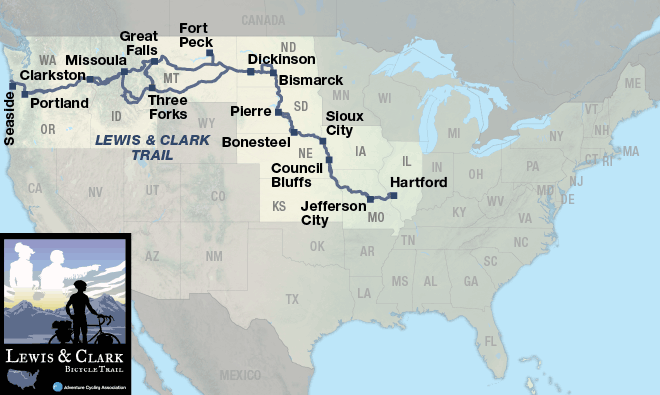
Lewis & Clark Trail
| Lewis & Clark Trail Hartford, IL to Seaside, OR 8 Map Set | GPX Data | Overview | Buy | Mobile App |
|---|---|
| 1. Hartford, IL to Council Bluffs, IA | Detail |
| 2. Council Bluffs, IA to Pierre, SD | Detail |
| 3. Pierre, SD to Dickinson, ND | Detail |
| 4. Dickinson, ND to Great Falls, MT | Detail |
| 5. Great Falls, MT to Missoula, MT | Detail |
| 6. Missoula, MT to Clarkston, WA | Detail |
| 7. Clarkston, WA to Seaside, OR | Detail |
| 8. Three Forks, MT to Glendive, MT | Detail |
Following in the footsteps of the Corps of Discovery.
The Lewis & Clark Bicycle Trail was created to celebrate the anniversary of the Corps of Discovery’s 1804-1806 historic journey and offers cyclists the opportunity to follow the path of the intrepid explorers Captains Meriwether Lewis and William Clark. It includes seven map sections detailing the 1804-1805 westbound trip, roughly following the Missouri and Columbia rivers, and one map section showing Clark’s 1806 eastbound return along the Yellowstone River in Montana.
The main route of the Lewis & Clark Bicycle Trail is made up of paved roads, bike paths, and unpaved rail-trails, with occasional short sections of gravel roads. Conditions vary from rural to urban.
Lewis and Clark’s expedition traveled more often by boat via rivers than by land and this route follows the rivers as closely as possible. Occasional rough roads, narrow to nonexistent shoulders, and sparse services make this one of our more challenging routes. Keeping this in mind, we recommend that you equip yourself with a wide-tired touring bicycle. Also, you’ll want to include a water filter on your packing list, as many of the campgrounds available are primitive and do not have potable water sources. If you use motels, plan ahead and be ready to ride some long days, perhaps as much as 100 miles. Distances between services in some areas can be substantial, so prior planning of your daily mileage is important.
Options and alternates offer much variety. The eight map sections show 4,500 mapped miles. Traveling the most historically correct (main) westbound route over Lemhi Pass, you will ride 3,132 miles to reach the Pacific Ocean. In total, there are 174 miles of unpaved rail-trails and 177.7 miles of gravel, 24.5 of which are unavoidable if you stay on the main route. Some options allow you to avoid gravel sections or get closer proximity to the Missouri River, whereas others offer historical side trips and rarely seen vistas like the view from Lewis and Clark Pass.
You will have many opportunities to pause and learn about the history of the Lewis and Clark Expedition at interpretive centers and museums that are along the route, in the smallest towns and largest cities. Probably the most impressive of these is the Lewis and Clark National Historic Trail Interpretive Center in Great Falls, Montana. In addition to Lewis and Clark-themed points of interest, the route also passes through five Indian reservations and features Native American and regional museums.
Plan on around two and a half months (give or take) for the most direct routing. Some will traverse the route quicker, but this leaves less time for sightseeing. This route can be ridden from May through September. Note that snow can occur at any time in the Rocky Mountains, and the highest pass on the route is over 7,300 feet. Although the prevailing weather patterns are from west to east, local wind patterns are more dependent on the passing pressure systems and local terrain, so you can expect your fair share of tailwinds and headwinds, regardless of which direction you ride the route.
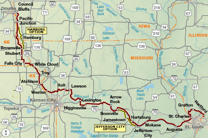
The route begins at the impressive Lewis and Clark State Memorial Park visitor center outside Hartford, Illinois. The center is near the mouth of the Wood River, on the opposite side of the Mississippi from where the Missouri feeds into it. It was at the mouth of the Wood where the members of the Lewis and Clark Expedition spent the winter of late 1803 and early 1804, making final preparations for a spring departure up the Missouri. After crossing the Mississippi River into Missouri, the route joins the Katy Trail — a converted rail bed. With its smooth surface of crushed limestone, the Katy traverses the floodplain of the Missouri, often running immediately beside the river and just above the water level. You can shorten the distance on the Katy by crossing the Missouri and using the Jefferson City Option. Much of the Missouri countryside that was wild frontier when Lewis and Clark passed through has been transformed into densely settled urban and suburban pockets. The Missouri River corridor is a heavily used recreational and industrial strip linking the St. Louis and Kansas City metropolitan areas. Kansas’s short contribution to the route, by comparison, is more rural, winding amidst rolling grain fields. At Brownville, Nebraska, you can ride the Steamboat Trace or choose the Hamburg Option. This 34-mile option is paved, with the exception of a 4.7-mile gravel stretch. Riding conditions in southeastern Nebraska and southwestern Iowa range from rural to urban, the latter particularly around Omaha-Council Bluffs.
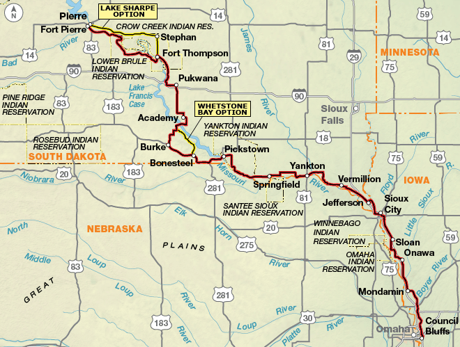
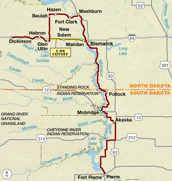
Between Council Bluffs and Sioux City, the riding tends to be either table-flat or very hilly, depending on whether you’re in the Missouri River floodplain or in the flanking Loess Hills. Roads around both of these Iowa cities can be very busy, so avoid riding them during the morning and afternoon commuting hours. West of Yankton, South Dakota, recreational vehicle traffic can be heavy, as it can be around any of the lake or dam access areas (Fort Randall, Chamberlain, Fort Thompson, etc.). Near Bonesteel, you will have the opportunity to ride closer to the river on the Whetstone Bay Option. This option is 25.5 miles in length, with 14.5 miles on a hard-packed dirt and gravel road with no services other than a campground. State Highway 1806 out of Fort Thompson carries less traffic, while dishing up extreme climbs and dramatic vistas. The actual Lewis and Clark Trail through this area — the Missouri River, that is — is less a river than a string of huge reservoirs, peppered with isolated communities and seasonal services. This trend continues into North Dakota and eastern Montana. From Fort Thompson, there are two ways into Pierre, South Dakota, continuing on the main route or following the Lake Sharpe Option. This 61-mile option, on the north side of the Missouri River, goes through the Crow Creek Indian Reservation.
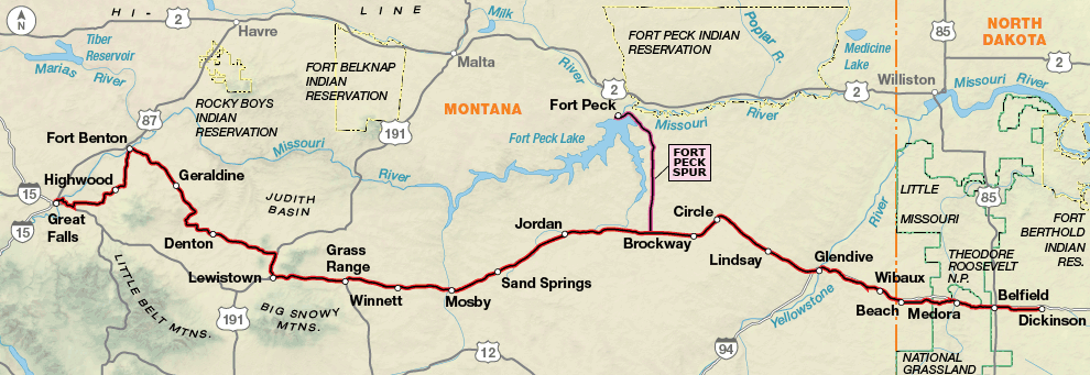
North of Pierre, you will ride through high, rolling bluff country that is typically some distance away from the river corridor but which occasionally proffers amazing views of the big body of water below. The route through the capital city of Bismarck, North Dakota, has two options: one urban through the heart of the city where services are located and the other on bike paths closer to the river. From Bismarck, the route heads north to a point near Stanton, then goes west and south to follow the I-94 corridor, alternating between the freeway and parallel county roads. This is a change from our original routing due to oil and gas development in the Bakken Oil Shale Field in western North Dakota and northeastern Montana. The route was changed in 2012 to avoid the area around Williston, North Dakota, because many roads with minimal to no shoulders now have high levels of truck traffic, and are felt to be unsafe for bicyclists. For further information read our blog post on the issue. You will miss some of the “Lewis & Clark experience” but reality intrudes, 200+ years later. It will be difficult to get motel rooms in this region, especially in Dickinson, North Dakota.
Initially in Montana — especially if you are bucking headwinds — the riding might be characterized as “put your head down and grin and bear it” conditions. You won’t actually lay eyes on the Missouri River for some 350 miles. But that is not to say that you will not experience some the most spectacular mountain-and-plains vistas in North America. At Circle, after turning west onto State Highway 200, the wind will be a concern; it can affect your steering and make it hard, or even impossible, to hear cars approaching from the rear. A rear-view mirror, always a good idea, is strongly suggested in windy areas such as these. If you want to go there, the 60.7-mile Fort Peck Spur takes you to the town of Fort Peck and the impressive Fort Peck Dam, one of the largest hydraulic earth-filled dams in the world. From Lewistown to Fort Benton, you’ll ride through the Montana of imagination, an idyllic scene that Charlie Russell, “America’s cowboy artist,” couldn’t have bettered.
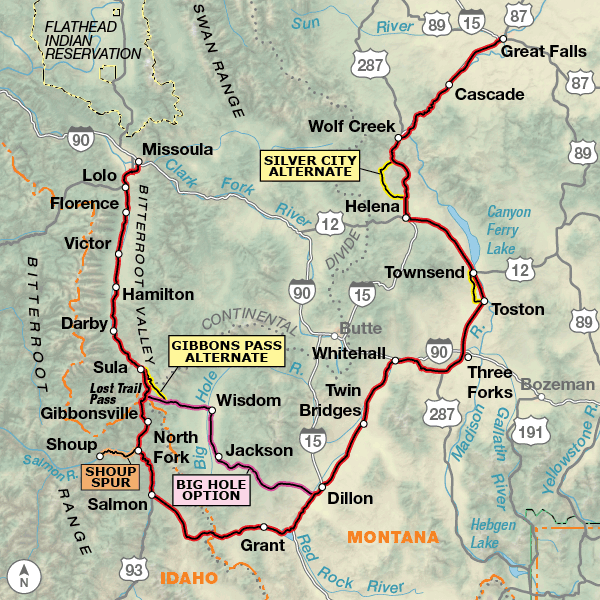
South of Great Falls, you will finally start getting into the canyons and mountains Montana is known for. A dividend of the terrific mountain scenery is that a large share of the lands are federally owned, so campgrounds become much more plentiful than they’ve been up to this point. At Three Forks, where the Gallatin, Madison, and Jefferson rivers merge, you’ll leave the Missouri River behind for good. Three miles south of Dillon, you will again be faced with choosing between two options, both of which include crossing the Continental Divide. Staying on Lewis and Clark’s 1804 westbound route takes you over Lemhi Pass, which includes 24.5 miles of gravel while the 87.2-mile paved Big Hole Option represents Clark’s 1806 eastbound journey. The Big Hole Option passes the Big Hole National Battlefield and Visitor Center that tells the tale of the Nez Perce and their flight to freedom. On this option, you will also encounter Clark’s 1806 eastbound route over Gibbon’s Pass.
The Bitterroot Valley, in western Montana, has become heavily populated in recent years. Traffic increases dramatically as you follow secondary roads and a separated bike path that parallels U.S. Highway 93. At Traveler’s Rest — a.k.a. the town of Lolo — the route heads north into Missoula. Here you can find several bike shops and visit the headquarters of Adventure Cycling Association. Although the site of Missoula was not encountered by Lewis and Clark during the expedition’s westbound travels, on the return trip east, the nine-man contingent led by Capt. Lewis passed the location of this future city.
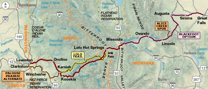
Leaving Montana, the route follows U.S. Highway 12 southwest from Lolo to Powell, Idaho, and you’ll be roughly tracing the actual route of Lewis and Clark. The main route continues west on its twisting way from Powell through the corridor of the Lochsa Wild and Scenic River. The Lochsa joins forces with the Selway River at Lowell, where the two transform into the Middle Fork of the Clearwater. Lewis and Clark didn’t use this river corridor and instead stayed on the mountain ridges to the north along an existing Indian trail.
Our 138.7-mile Lolo Trail Option climbs high up along ridge lines to access the rough roller coaster of a dirt road known as the Lolo Motorway or the High Road. Due to the rugged, mountainous terrain and scarcity of services and water, only fit, experienced mountain bikers should attempt this option.
At Kamiah (KAM-ee-eye), the main route continues to use U.S. Highway 12. While the Idaho Transportation Department and local cyclists do not recommend riding between Kamiah and Lewiston, we use it for those Lewis and Clark afficionados who want to follow the Expedition’s route as closely as possible. Over the course of the 51 miles between Kamiah and Arrow Bridge there are about 2 miles without shoulders. Please practice defensive riding techniques, ride single file and early in the day, and it’s best to ride this on a weekend. Westbound riders will experience stretches where the roadway is up against concrete barriers with the river on the other side, so there’s no place to bail out. If you are uncomfortable with this type of riding please use the 87.5-mile Palouse Prairie Alternate.
The main route is 19 miles shorter than the Palouse Prairie Alternate. Local cyclists recommended this routing, up and over the Camas and Nezperce prairies, to get to Lewiston and Clarkston and avoid the shoulderless portions of U.S. Highway 12. State Highway 162 and State Highway 7 have little traffic, and U.S. Highway 95 has wide shoulders.
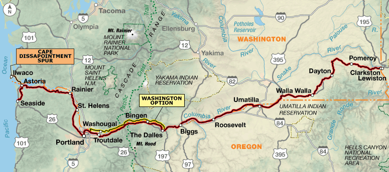
West of Clarkston, where the Snake River bends northwest, you’ll leave Lewis and Clark’s westbound route and not join it again until you reach the Columbia River near Walla Walla, Washington. Much of the bicycle route between these two cities, however, does follow the approximate overland route taken by the Corps in early May 1806. Your windy — and potentially very hot — ride through the Columbia River Gorge and on to the coast will be a study in contrasts: from stretches of traffic-clogged I-84 to a couple of closed-to-cars sections of the Historic Columbia River Highway, now a beautiful state trail, and from the bustle of metropolitan Portland to small, serene communities that barely earn a dot on the map. The main route includes riding on the shoulders of I-84 for 6 miles. This interstate has high levels of traffic, so that’s why an alternate is offered. Via the Washington Option through the gorge, you’ll find State Highway 14 has non-existent to variable shoulder widths, frequent truck traffic, and few services. Two series of tunnels have buttons to activate “Bikes in Tunnel” lights. This option is 3.6 miles shorter and rejoins the main route in Portland.
U.S. Highway 30, unfortunately, is a busy way to end the trip, but there’s a good reason all of those motorists are heading west: to get out to that beautiful coastline. Several short detours off the highway are included in the route wherever possible. The route passes Fort Clatsop Interpretive Center in the Lewis & Clark National Historic Park, the Corps’ 1805-1806 winter quarters, and continues on to Seaside, where the Corps processed seawater into salt for their return journey. From Astoria, the 19.3-mile Cape Disappointment Spur crosses the Columbia River into Washington and heads west to Cape Disappointment State Park.
In the spring of 1806, the Corps began their return journey to St. Louis. To cover more area and gather more information, they divided into two parties at Traveler’s Rest in Lolo, Montana. Capt. Lewis and nine men returned to the great falls of the Missouri via the Blackfoot River and the Sun River, crossing the Continental Divide at what would later be called Lewis and Clark Pass. This part of the journey is mapped in the 188-mile Blackfoot Option east of Missoula on map section 6. It uses two-lane highways that parallel the Blackfoot and Sun rivers. A 13-mile gravel spur along Alice Creek is shown for those who want to ride/hike up to Lewis and Clark Pass to view what Lewis and his men saw. This option ends in Great Falls, Montana.
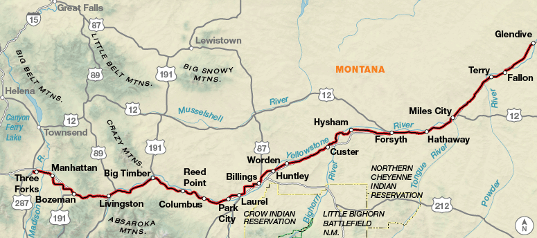
Capt. Clark and the rest of the expedition returned to Camp Fortunate (Clark Canyon Reservoir) and then to the Missouri-Yellowstone confluence. This 417-mile journey is reflected in map section 8 beginning in Three Forks, Montana. In general, the route stays on Interstate 90 and the frontage roads that parallel it. Services can be few and far between the farther east the route goes. You’ll have a gentle climb over Bozeman Pass to get into the Yellowstone River drainage. The route is slightly rolling with great views of the Yellowstone River. Between Bozeman and Glendive the route occasionally uses the interstate when there is no frontage road. Use caution when entering and exiting the ramps, as most of them have cattle guards. The interstate does have a wide shoulder and carries light traffic as far as interstates go, but use caution as the traffic does travel at high speed. Pompey’s Pillar, the site where you can see William Clark’s signature, is 7.7 miles northeast of Worden, and a half mile off the route.
Part of a Larger Effort
In response to all of the interest and activity in the years leading up to the bicentennial celebration, the National Council of the Lewis & Clark Bicentennial was formed. Working hand in hand with federal and state agencies, Indian tribes, and other groups and individuals, the council coordinated dozens of partners, programs, and events commemorating the bicentennial. The staff, board of directors, and members of Adventure Cycling are proud that their organization had a part to play in that greater effort. The council recognized the Lewis & Clark Bicycle Trail map series as part of the nationwide celebration.
Portions of the above text are excerpted from the book “Bicycling the Lewis and Clark Trail,” published in spring 2003 by Globe Pequot Press in cooperation with Adventure Cycling Association.
Major funding for the Lewis & Clark Bicycle Trail has been provided by REI. Sections of this route have been sponsored by Sierra Club and Mr. James C. Becker, Vancouver, Washington.
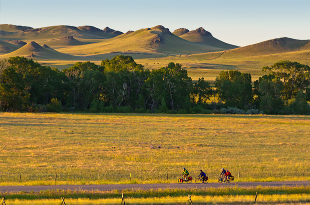
Photo by Chuck Haney
The main route of the Lewis & Clark Bicycle Trail is made up of paved roads, bike paths, and unpaved rail-trails, with occasional short sections of gravel roads. Conditions vary from rural to urban and include windy stretches lacking in shoulders.
Conditions will vary from the table-flat floodplains to hilly stretches. Once you reach eastern Montana headwinds will become a factor across much of the state until you reach the west and mountains to cross the Continental Divide.
Section 8 follows Interstate 90 and the frontage roads that parallel it. You’ll have a gentle climb over Bozeman Pass to get into the Yellowstone River drainage. The route is slightly rolling with great views of the Yellowstone River. Use caution when entering and exiting the ramps, as most of them have cattle guards. The interstate does have a wide shoulder and carries light traffic as far as interstates go, but use caution as the traffic does travel at high speed.
| Lewis & Clark Trail - Main Route | ||||
|---|---|---|---|---|
| Section | Distance | Elevation | Total Climb | Avg. Climb/mile |
| Total | 3547.3 miles | Minimum: 0 ft.Maximum:7,375 ft. | 136,220 ft. west bound134,800 ft. east bound | 38 ft. per mi. west bound38 ft. per mi. east bound |
| 1 | 554.5 miles | Minimum: 420 ft.Maximum:1,175 ft. | 18,435 ft. west bound18,125 ft. east bound | 33 ft. per mi. west bound33 ft. per mi. east bound |
| 2 | 488.5 miles | Minimum: 980 ft.Maximum:2220 ft. | 14,860 ft. west bound14,395 ft. east bound | 30 ft. per mi. west bound29 ft. per mi. east bound |
| 3 | 409.5 miles | Minimum: 1,435 ft.Maximum:2,570 ft. | 18,245 ft. west bound17,260 ft. east bound | 45 ft. per mi. west bound42 ft. per mi. east bound |
| 4 | 497.1 miles | Minimum: 2,045 ft.Maximum:4,725 ft. | 23,480 ft. west bound22,575 ft. east bound | 47 ft. per mi. west bound45 ft. per mi. east bound |
| 5 | 470.1 miles | Minimum: 3,120 ft.Maximum:7,375 ft. | 18,685 ft. west bound18,655 ft. east bound | 40 ft. per mi. west bound40 ft. per mi. east bound |
| 6 | 222.5 miles | Minimum: 720 ft.Maximum:5,235 ft. | 7,070 ft. west bound9,760 ft. east bound | 32 ft. per mi. west bound44 ft. per mi. east bound |
| 7 | 484.4 miles | Minimum: 0 ft.Maximum:2,785 ft. | 22,030 ft. west bound22,950 ft. east bound | 45 ft. per mi. west bound47 ft. per mi. east bound |
| 8 | 420.7 miles | Minimum: 2,060 ft.Maximum:5,865 ft. | 13,415 ft. west bound11,080 ft. east bound | 32 ft. per mi. west bound26 ft. per mi. east bound |
| Lewis & Clark Trail Alternates | ||||
|---|---|---|---|---|
| Name | Section | Distance | Total Climb | Avg. Climb/mile |
| Jefferson City Option | 1 | 54.6 miles | 3,355 ft. west bound3,305 ft. east bound | 61 ft. per mi. west bound61 ft. per mi. east bound |
| Hamburg Option | 1 | 43.0 miles | 750 ft. west bound745 ft. east bound | 17 ft. per mi. west bound17 ft. per mi. east bound |
| Whetstone Bay Option | 2 | 25.5 miles | 1,680 ft. west bound1,595 ft. east bound | 66 ft. per mi. west bound63 ft. per mi. east bound |
| Lake Sharpe Option | 2 | 61.0 miles | 1,840 ft. west bound1,850 ft. east bound | 30 ft. per mi. west bound30 ft. per mi. east bound |
| I-94 Cut | 3 | 50 miles | 2,430 ft. west bound1,955 ft. east bound | 49 ft. per mi. west bound39 ft. per mi. east bound |
| River Trail Option | 3 | 4 miles | 40 ft. west bound45 ft. east bound | 10 ft. per mi. west bound11 ft. per mi. east bound |
| Fort Peck Spur | 4 | 60.7 miles | 3,180 ft. north bound3455 ft. south bound | 52 ft. per mi. north bound57 ft. per mi. south bound |
| Silver City Alternate | 5 | 21.7 miles | 575 ft. west bound855 ft. east bound | 26 ft. per mi. west bound39 ft. per mi. east bound |
| Gravel Alternate | 5 | 16.3 miles | 950 ft. west bound845 ft. east bound | 58 ft. per mi. west bound52 ft. per mi. east bound |
| Shoup Spur | 5 | 18.2 miles | 800 ft. west bound1040 ft. east bound | 44 ft. per mi. west bound57 ft. per mi. east bound |
| Old Darby Alternate | 5 | 12.9 miles | 360 ft. east bound600 ft. west bound | 28 ft. per mi. east bound47 ft. per mi. west bound |
| Big Hole Option | 5 | 87.2 miles | 5,455 ft. north bound3,705 ft. north bound | 63 ft. per mi. north bound42 ft. per mi. north bound |
| Gibbons Pass Alternate | 5 | 17.7 miles | 670 ft. west bound2470 ft. east bound | 38 ft. per mi. west bound140 ft. per mi. east bound |
| (Missoula) Alternate | 5 | 5.4 miles | 135 ft. west bound75 ft. east bound | 25 ft. per mi. west bound14 ft. per mi. east bound |
| Blackfoot Option | 6 | 188.0 miles | 8,310 ft. east bound8,290 ft. west bound | 44 ft. per mi. east bound44 ft. per mi. west bound |
| Lolo Trail | 6 | 138.7 miles | 17,040 ft. west bound21,270 ft. east bound | 123 ft. per mi. west bound153 ft. per mi. east bound |
| Alice Creek Spur | 6 | 13.0 miles | 1,770 ft. north bound245 ft. south bound | 136 ft. per mi. north bound19 ft. per mi. south bound |
| Palouse Prairie Alternate | 6 | 87.5 miles | 6,025 ft. west bound6,600 ft. east bound | 69 ft. per mi. west bound75 ft. per mi. east bound |
| Alternate | 6 | 5.4 miles | 75 ft. west bound135 ft. east bound | 14 ft. per mi. west bound25 ft. per mi. east bound |
| Washington Option | 84.1 miles | 4,720 ft. west bound5,175 ft. east bound | 56 ft. per mi. west bound62 ft. per mi. east bound | |
| Cape Disappointment Spur | 7 | 19.3 miles | 480 ft. west bound510 ft. east bound | 26 ft. per mi. west bound26 ft. per mi. east bound |
Occasional rough roads, narrow to nonexistent shoulders, and sparse services make this one of our more challenging routes. Keeping this in mind, we recommend that you equip yourself with a wide-tired touring bicycle. Also, you’ll want to include a water filter on your packing list, as many of the campgrounds available are primitive and do not have potable water sources. If you use motels, plan ahead and be ready to ride some long days, perhaps as much as 100 miles. Distances between services in some areas can be substantial, so prior planning of your daily mileage is important.
Plan on around two and a half months (give or take) for the most direct routing. Some will traverse the route quicker, but this leaves less time for sightseeing.
This route can be ridden from May through September. Note that snow can occur at any time in the Rocky Mountains, and the highest pass on the route is over 7,300 feet. Although the prevailing weather patterns are from west to east, local wind patterns are more dependent on the passing pressure systems and local terrain, so you can expect your fair share of tailwinds and headwinds regardless of which direction you ride the route.
Some campgrounds will charge a cyclist traveling alone less if they have hiker/biker sites, but often they will charge the price of a regular tent or RV site, and that can easily be $10-$40/night. The maps often list churches that have opened their doors to cyclists, but they aren’t all that closely spaced. If you’re friendly and ask around, you can often get yourself invited to camp in a yard. Our routes sometimes go through national forests (moreso in the west) and you are allowed to camp anywhere on national forest land as long as you “pack it in, pack it out.” Many city parks are free to camp in.
You may also wish to sign up with Warmshowers, a reciprocal hospitality site for bicycle travelers, for other overnight options.
Route Highlights
Lewis & Clark Trail Highlights
- Gateway Arch – Jefferson National Expansion Memorial, Section 1
- Arrow Rock State Historic Site, Section 1
- Western Historic Trails Center, Section 1
- Sergeant Floyd Riverboat Museum, Section 2
- Spirit Mound, Section 2
- Sakakawea Monument, Section 3
- Fort Abraham Lincoln State Park, Section 3
- Fort Mandan, Section 3
- Knife River Villages National Historic Site, Section 3
- Theodore Roosevelt National Park, Section 4
- Fort Peck Spur, Section 4
- Fort Benton, Section 4
- Great Falls, Sections 4, 5 and 6
- Lewis and Clark National Historic Trail Interpretive Center, Great Falls, Montana, Sections 4 and 5
- Tower Rock State Park, Section 5
- Gates of the Mountains, Section 5
- Travelers’ Rest State Park, Section 5
- Lewis and Clark Pass, Blackfoot Option, Alice Creek Spur, Section 6
- Hells Gate State Park, Hells Gate Option, Section 6
- Lewis & Clark Trail State Park, Section 7
- Whitman Mission National Historic Site, Section 7
- Hat Rock State Park, Section 7
- Columbia River Gorge, Section 7
- Beacon Rock State Park, Washington Option, Section 7
- Multnomah Falls, Section 7
- Lewis and Clark National Historical Park, Section 7
- Cape Disappointment Spur, Section 7
- Salt Works, Section 7
- Three Forks, Section 8
- Pompeys Pillar National Historic Landmark, Section 8
More Route Resources
- Discovering Lewis & Clark
- How to Plan Your Bike Trip Using Amtrak
- No-Turn-Away Bike Camping Policies (Missouri and Washington)
- Katy Trail (Missouri)
- Runge Conservation Nature Center (Missouri)
- Wabash Trace Nature Trail (Iowa)
- Siouxland Trails Foundation (Iowa, Nebraska, South Dakota)
- Charles M. Russell National Wildlife Refuge (Montana)
- American Prairie Reserve (Montana)
- Upper Missouri River Breaks National Monument (Montana)
- The River’s Edge Trail (Montana)
- The Lolo Trail, mountain bike option (Idaho)
- How to Mountain Bike Tour
- Historic Columbia River Highway State Trail (Oregon)
- Northwest Oregon Routing Resources (Oregon)
- Portland Airport Bicycle Resources (Oregon)
- Portland Bike Map (Oregon)
- USBR 20 (Washington)
- Tillamook County Transportation District bus between Portland and the coast (Oregon)
- Connect and share photos with other riders on Instagram: #acaLewisClark
Updates to Recently Released Maps
If you are planning a bike tour, be sure to get the most recent map updates and corrections for your route by selecting the route, and the appropriate section(s), from the drop-down menu below.
Over time maps become less useful because things change. Every year Adventure Cycling’s Routes and Mapping Department create map updates and corrections for every map in the Adventure Cycling Route Network, which now totals 52,047 miles. With the help of touring cyclists like you, we receive updates on routing, services, camping, and contact information. Until we can reprint the map with the new information, we verify the suggested changes and publish corrections and updates here on our website.
PLEASE NOTE: Covid has been particularly hard on the small businesses along our routes. While we do our best to keep the maps and these online updates current, you may encounter more closed businesses and longer stretches with limited or no services.
Refer to these updates for the most current information we have and submit reports of changes to the Route Feedback Form for the cyclists coming after you.
NOTE: Map updates and corrections only pertain to long term changes and updates. For short term road closures, please see the Adventure Cycling’s Routes Temporary Road Closures discussion in our Forums.