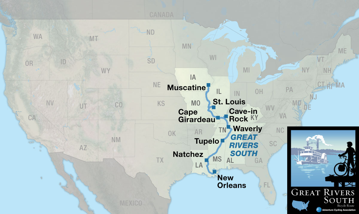
Great Rivers South

Great Rivers South Muscatine, IA to New Orleans, LA 3 Map Set GPX Data | Overview | Buy | Mobile App
1. Muscatine, IA to Cape Girardeau, MO Detail
2. Cape Girardeau, MO to Tupelo, MS Detail
3. Tupelo, MS to New Orleans, LA Detail

Experience history of Mormons, Mark Twain, Mississippi, and much more.

The Great Rivers South Bicycle Route boasts a subtle beauty, replete with farmland, woods, caverns, rivers, and waterfalls. There’s quite a bit of history along the route as you’ll see in Nauvoo, Illinois, the town from which the Mormons were driven out in the 1800s, and Hannibal, Missouri, Mark Twain’s hometown. You’ll also pass a pirate’s cave on the Ohio River, an old Civil War fort, and antebellum homes in Natchez, Mississippi.

Although titled the Great Rivers South Bicycle Route, you’ll hardly ride any long stretches along rivers. Instead, you’ll cross many of the great rivers that feed into the Mississippi.

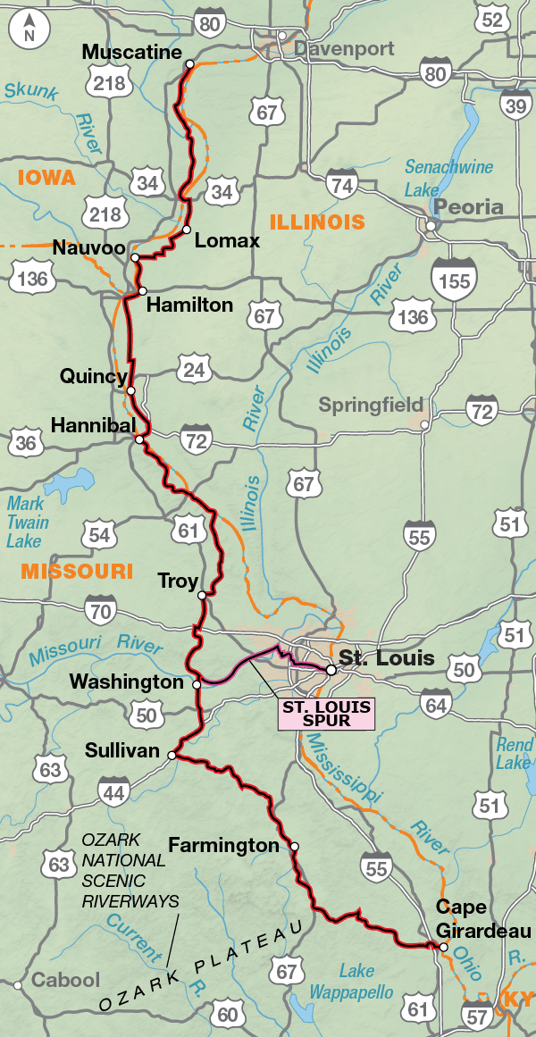
Starting in Muscatine, Iowa, you ride on the west side of the river, beside the Mark Twain National Wildlife Refuge. You’ll particularly enjoy the 11-mile stretch between Nauvoo and Hamilton, where you’ll be alongside the Mississippi River. After crossing the bridge into Hannibal, Missouri, you will see a town most famous as the boyhood home of Samuel Clemens (a.k.a. Mark Twain). This town has tourist sites based on characters and places from his books, e.g., Tom Sawyer’s fence, Becky Thatcher’s home, Grant’s Drug Store, and Mark Twain’s Cave. Heading southward, you’ll encounter hilly farm country. If you want, you can take a side trip into St. Louis to see the famous Gateway Arch.

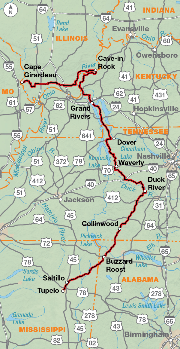
Be prepared to use your granny gears off and on through the Ozark Mountain Range until Cape Girardeau, Missouri, where you cross back into Illinois. This means more farm country, and then you’ll cross the Ohio River by ferry into Kentucky. You’ll be using your granny gears again, and then you’ll enjoy a very pleasant ride along The Trace Road in the Land Between the Lakes Recreation Area, an expanse of woods where buffalo roam. No commercial vehicles are allowed on this road, and a 45 mph speed limit is strictly enforced.

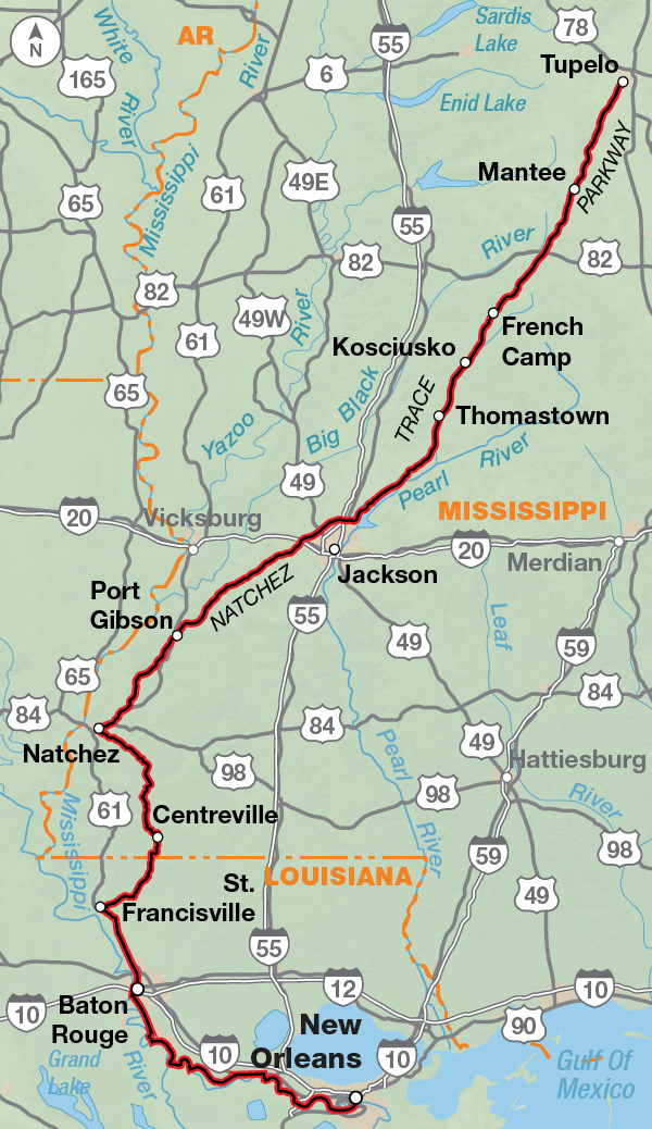
The route on the Natchez Trace follows a two-lane road in a national park that continues through Alabama and Mississippi, with no commercial traffic or services permitted. All services, except for occasional campgrounds, are off the route in nearby towns. You’ll encounter fellow bicyclists and enjoy many hiking trails, boardwalks, waterfalls, and historical sites along the Trace. At the end of the Trace, you can visit the antebellum homes in Natchez, Mississippi. The route goes through the rural countryside in northern Louisiana. Between Baton Rouge and New Orleans the route follows portions of the mostly paved Mississippi River Levee Path.

Photo by Adam Coppola

From Muscatine, Iowa to Hannibal, Missouri, you’ll be riding in the relatively flat floodplain of the Mississippi River. South of Hannibal the route follows river bluffs with steep, roller coaster hills. After leaving the river, you’ll be in Missouri hill country with many farms in the valleys. Before crossing the Missouri River, you’ll ride 3.9 miles on the crushed limestone KATY Trail before entering the Ozark Mountains which give way to the alluvial plains returning to the Mississippi River. Across Kentucky and Tennessee moderate to challenging rolling hills are the norm until you reach the more gently graded Natchez Trace. From Natchez, Mississippi to Baton Rouge, Louisiana the route returns to gently rolling hills through rural farmlands. The route is flat between Baton Rouge and New Orleans.

Great Rivers South - Main Route
Section Distance Elevation Total Climb Avg. Climb/mile
Total 1385.0 miles Minimum: 0 ft.
Maximum:1,080 ft.
62,450 ft. south bound
63,410 ft. north bound
45 ft. per mi. south bound
46 ft. per mi. north bound
1 452.7 miles Minimum: 680 ft.
Maximum:1,080 ft.
22,460 ft. south bound
22,885 ft. north bound
50 ft. per mi. south bound
51 ft. per mi. north bound
2 451.5 miles Minimum: 270 ft.
Maximum:1,080 ft.
25,870 ft. south bound
26,120 ft. north bound
57 ft. per mi. south bound
58 ft. per mi. north bound
3 480.5 miles Minimum: 0 ft.
Maximum:575 ft.
14,120 ft. south bound
14,405 ft. north bound
29 ft. per mi. south bound
30 ft. per mi. north bound
Great Rivers South Alternates
Name Section Distance Total Climb Avg. Climb/mile
St. Louis Spur 1 57.7 miles 1,630 ft. east bound
1,665 ft. west bound
28 ft. per mi. east bound
29 ft. per mi. west bound
Bike Path Option 3 10.7 miles 645 ft. south bound
620 ft. north bound
60 ft. per mi. south bound
58 ft. per mi. north bound

The Great Rivers South Bicycle Route can be ridden from mid-spring to late fall (typically April to October), and even into the winter on the southern portion. Due to changing local conditions, it is difficult to predict any major wind patterns. High summer temperatures and humidity can cause discomfort if you’re not used to either. Tornadoes are common in Illinois and Missouri. They occur mostly in May and June. Facilities and services are limited along the Natchez Trace and camping usually primitive when available.

Some campgrounds will charge a cyclist traveling alone less if they have hiker/biker sites, but often they will charge the price of a regular tent or RV site, and that can easily be $10-$40/night. The maps list churches that have opened their doors to cyclists, but they aren’t all that closely spaced. If you’re friendly and ask around, you can often get yourself invited to camp in a yard. Our routes goes through national forests (moreso in the west) and you are allowed to camp anywhere on national forest land as long as you “pack it in, pack it out.” Many city parks are free to camp in.

You may also wish to sign up with Warmshowers, a reciprocal hospitality site for bicycle travelers, for other overnight options.

Route Highlights

Great Rivers South Highlights

  • Nauvoo State Park, Section 1
  • Mark Twain Boyhood Home & Museum, Section 1
  • Katy Trail/St. Louis Spur, Section 1
  • Cave-In-Rock State Park, Section 2
  • Woodlands Trace National Scenic Byway, Section 2
  • Natchez Trace Parkway, Section 2 & 3
  • Meriwether Lewis National Monument, Section 2
  • Tupelo National Battlefield, Section 2
  • Elvis Presley Birthplace, Section 3
  • Ruins of Windsor, Section 3
  • Port Hudson State Commemorative Area, Section 3

More Route Resources

RIDING CONDITIONS

From Muscatine, Iowa, southward to Hannibal, Missouri, the route closely follows the flood plain of the Mississippi River. These riverside roads in Iowa and Illinois are rural farm-to-market roads, connecting small farming communities along the river and providing access to shipping terminals for local farm products. They are narrow, winding blacktop roads with no shoulders and little traffic. The traffic is higher on the crossroads which lead to bridges crossing the Mississippi River.

Cyclists are allowed on the I-72 bridge crossing into Hannibal, Missouri. South of Hannibal, SR 79 follows the river bluffs which continue to the river’s edge. There are steep, roller coaster hills here with rewarding river overlooks at signed pullouts along the way.

Leaving the river at Clarksville, cyclists will enjoy narrow, almost traffic-free roads through the central Missouri hill country. This is an area of small towns and farms tucked into valleys. In Troy, watch out for sewer grates which have wide spacing and can eat tires.

The route follows 3.8 miles of the Katy Trail between Marthasville and Dutzow. Travel on the Katy Trail will be slower due to its crushed limestone surface, though more pleasant than the highly trafficked SR 47/94. SR 47 between Washington and Union has shoulders.

South of Washington, you’ll be entering the Ozark Mountain range. Many of the state and county roads you’ll be on are narrow, winding, and steep, with short sight distances. After Cherokee Pass, the route leaves the Ozarks and moves onto the alluvial plains of southeastern Missouri to Cape Girardeau.

Loose dogs abound in rural Missouri so you will likely encounter them. Be prepared. Here is an article about cycling and dogs: advcy.link/dogs.

The 57.7-mile spur route into St. Louis includes 31.1 miles on the Katy Trail. After crossing the Missouri River you’ll switch to urban cycling as the route heads into the heart of the city. With care, riders who are accustomed to larger cities will have no problem with this spur to downtown St. Louis and the famous Gateway Arch. Due to heavy traffic, the downtown portion should be ridden only during daylight hours. Another option for seeing the city is to take the train from Washington to Union Station in downtown St. Louis. All known Amtrak stations on the route are listed on this map but not all stations provide bicycle service. Check if bicycle service is provided at both the starting and ending stations on your trip using the spreadsheet and other trip planning resources at advcy.link/amtrak.

NOTE: If cycling this route to enjoy the fall colors, we recommend you call ahead to campgrounds to verify that they are open. Many close after Labor Day.

CLIMATE

The continental climate of Iowa, Illinois, and Missouri is subjected to frequent changes. The three primary causes of these changes are: (1)cold air moving down from the north; (2)warm, moist air entering from the south and the Gulf of Mexico; and (3)dry air from the western plains sweeping in. Occasional periods of prolonged heat, high humidity, and afternoon thunderstorms occur during the summer.

Tornadoes are also common. The yearly average is 20 twisters, most of which occur in May and June. Most tornadoes usually move from the southwest to the northeast, at the rate of about 25 to 40 miles per hour. Their path of travel can be erratic. If you see one on the horizon, seek shelter below ground at a farmhouse, if at all possible. If not, find a ditch or low spot and wait out the storm.

Updated: Nov 9, 2020

RIDING CONDITIONS

The state highways in Illinois are wide two-lane roads with moderate traffic and no shoulders. Most of the rest of the route is on narrow two-lane county roads with no shoulder and very little traffic. Rolling hills are the norm except for SR 146 and SR 3, which are in the Mississippi flood plain. You’ll cross the Ohio River at Cave-In-Rock on a ferry also used by TransAmerica Trail cyclists.

U.S. Bicycle Route (USBR) 76 is not signed in Illinois, but is in Kentucky. Our routing is not always concurrent with USBRs. For more information and maps see http://advcy.link/ilusbr76, advcy.link/ilusbr76 and advcy.link/kyusbr76. Be aware that signs can be damaged, stolen, or otherwise missing so you can never rely totally on following signs.

In western Kentucky the route follows very lightly traveled county roads over short steep hills until meeting US 60, near Smithland, which has moderate traffic. Recreational traffic increases south of I-24 and Grand Rivers.

The Woodlands Trace National Scenic Byway, or “The Trace Road” through the Land Between the Lakes Recreation Area (LBL) is a two-lane road with no shoulders and light to moderate traffic. No commercial vehicles are allowed and a 45-mph speed limit is strictly enforced. Campgrounds in the LBL are on a first come, first served basis and fill quickly on summer weekends.

In Tennessee, the route travels over exhausting roller coaster hills on two-lane county roads and state highways. US 79 west of Dover has wide paved shoulders and heavy traffic. SR 48 near Nunnelly has moderate traffic. Otherwise, traffic is light.

SR 100 north of Centerville and SR 50 west of Duck River have been rumble-stripped. Traffic can be heavy on these two highways, please ride with caution. Just east of the town of Duck River, signed Shady Grove, you will join the Natchez Trace Parkway.

The Parkway is a scenic, two-lane road with no shoulders and light traffic, except near and through towns. The road surface is rough chip-seal. No commercial traffic is permitted on the Parkway and a 50-mph speed limit is strictly enforced. The width of the Natchez Trace varies from 400 feet to 1,000 feet, with a wider right-of-way at areas of historical, scientific, and recreational value. Near and in any national park cyclists will have to contend with RV drivers who are inexperienced. Make yourself and your bike visible. The National Park Service advises cyclists to avoid riding the Parkway between Mileposts 258 and 270 through Tupelo during the hours of 7:00 – 9:00 a.m. and 3:00 – 6:00 p.m. due to increased volumes of traffic.

The Parkway is marked at one mile intervals in its entirety; a few of these mileposts have been indicated on the maps for reference. All lands outside of this boundary, with the exception of the Tombigbee National Forest, are privately owned and require owner permission to use. Facilities for cyclists are few and far between, but water is located at the restrooms shown on the Park brochure. Call 800-305-7417 or go to www.nps.gov/natr to download the map. Camping on the Parkway is usually primitive and very limited, so you might need to plan on a few indoor overnights.

NOTE: If cycling this route to enjoy the fall colors, we recommend you call ahead to campgrounds to verify that they are open. Many close after Labor Day.

CLIMATE

The climate in this area of states (southern IL, western KY and TN, northern AL and MS) is continental in character, with the Gulf of Mexico influencing the southern portion into a more semitropical climate. All the lands lie within the drainage of the Mississippi River system. Warm, humid summers with thunderstorms are the norm and temperatures increase the farther south you go. Precipitation is lightest in the fall.

Updated: Sep 16, 2019


RIDING CONDITIONS

For most of this map section, cyclists will enjoy a nearly traffic-free ride on the Natchez Trace Parkway. The two-lane road is gently graded and the road surface is mainly smooth. Although there are no paved shoulders, the road edges merge evenly onto a grass shoulder. No commercial traffic is permitted on the Parkway and a 50 mph speed limit is strictly enforced. The Parkway is marked at one mile intervals in its entirety; several of these mileposts have been indicated on the maps for reference.

To request a Parkway brochure call the National Park Service (NPS) at 800-305-7417 or go to www.nps.gov/natr to download a map and read their suggestions and rules for bicycle travel. Brochures are also available along the Parkway at these locations: Parkway Visitor Center (milepost 266), Kosciusko Visitor Center (milepost 160), metro Jackson area bike shops and sports stores, and the Mount Locust Information Center (milepost 15.5).

Traffic leaving Tupelo can be light to moderate. Between Tupelo and the Tombigbee National Forest you will see fields, meadows, and woods. If you visit Kosciusko, exit the Parkway at milepost 160 onto SR 35; do not use SR 12. The highway has no shoulder and carries a moderate amount of logging traffic.

The NPS suggests that cyclists avoid the following areas during heavy traffic periods: Clinton to Ridgeland, Mississippi, mileposts 87-103 from 7:00-9:00 a.m. and from 4:00-6:00 p.m. and Tupelo, Mississippi, mileposts 258-268 from 7:00-8:30 a.m. and 4:00-6:00 p.m. on weekdays.

There is a 10.4-mi. separate multi-use path through Ridgeland that parallels the Parkway. It’s a nice respite from traffic. The northern end is accessed at the Reservoir Overlook. The southern end stops at a red and white barricade, then you have to walk your bike across 50 yards of grass to access the Parkway. Follow the instructions on the map if you decide to ride the path.

South of Clinton cyclists will be traveling through open fields of hay, cotton, and soybeans all the way to Port Gibson, where the route starts winding through gently rolling hills.

The Parkway ends in Natchez. Continuing southward you’ll ride through rural areas of southern Mississippi and Louisiana, where narrow two-lane roads and timberland dominate the scenery.

U.S. 61, a two-lane road with 4-foot or better shoulders, leads you into downtown Baton Rouge; traffic volumes will increase as you approach the heart of the city. You will pass the Baton Rouge Airport which may be accessed via Rosenwald Rd. The route ends at the Louisiana State Capitol building. If you want to continue southward to New Orleans, contact the Baton Rouge Advocates for Safe Streets for route suggestions at www.brsafestreets.org.

NOTE: If cycling this route to enjoy the fall colors, we recommend you call ahead to campgrounds to verify that they are open. Many close after Labor Day.

CLIMATE

The climate of Mississippi and Louisiana is determined by the huge land mass to the north, its subtropical latitude, and the Gulf of Mexico.

The prevailing southerly winds provide a moist, subtropical climate, with conditions often favorable for afternoon thunderstorms. High humidity during the summer and fall months produces discomfort. Thunderstorms provide the principal relief from the heat, though they can include locally violent winds.

In the colder season both states are subjected to warm tropical air from the south and cold continental air from the north. Cold spells seldom last more than 3 or 4 days, and the coldest temperatures average in the mid-40’s.

Updated: Dec 18, 2017

Updates to Recently Released Maps

If you are planning a bike tour, be sure to get the most recent map updates and corrections for your route by selecting the route, and the appropriate section(s), from the drop-down menu below.

Over time maps become less useful because things change. Every year Adventure Cycling’s Routes and Mapping Department create map updates and corrections for every map in the Adventure Cycling Route Network, which now totals 52,047 miles. With the help of touring cyclists like you, we receive updates on routing, services, camping, and contact information. Until we can reprint the map with the new information, we verify the suggested changes and publish corrections and updates here on our website.

PLEASE NOTE: Covid has been particularly hard on the small businesses along our routes. While we do our best to keep the maps and these online updates current, you may encounter more closed businesses and longer stretches with limited or no services.

Refer to these updates for the most current information we have and submit reports of changes to the Route Feedback Form for the cyclists coming after you.

NOTE: Map updates and corrections only pertain to long term changes and updates. For short term road closures, please see the Adventure Cycling’s Routes Temporary Road Closures discussion in our Forums.