Florida Connector
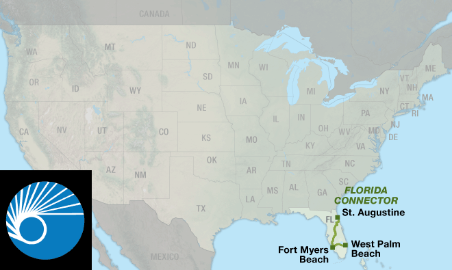
| Florida Connector St. Augustine, FL to West Palm Beach, FL 1 Map Set | GPX Data | Overview | Buy | Mobile App |
|---|---|
| 1. St. Augustine, FL to West Palm Beach, FL | Detail |
See Florida from coast to coast to coast.
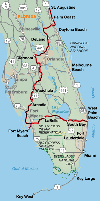
The Florida Connector creates the opportunity for two loop routes in Florida that are ideal for cycling December through March. It joins the Atlantic Coast Route, Section 7, in St. Augustine and West Palm Beach creating the first loop option. A second loop encompassing West Palm Beach, Key West, and Fort Myers Beach via a ferry is also possible.
Florida has an extensive though sometimes confusing network of bicycling facilities ranging from 2-foot bike lanes or shoulders to separated bike paths and sidewalks. Some stretches are better suited to sidewalk cycling due to moderate to heavy traffic; in other areas sidewalks will be pedestrian use only. The approach to often nearly invisible short bridges are usually marked with “frogs”, “buttons”, “turtles”, “slugs” or rumble strips.
Heading south from St. Augustine mostly on SR A1A, the route alternates between urban and suburban conditions along the coast until it swings west at Bulow Creek State Park. You will wind your way through many lakes and sinkholes. Sometimes you’ll see huge trucks filled with oranges, and you may even see a live (or dead) armadillo along the side of the road. In the Orlando area, you’ll experience the mind-boggling traffic and myriad services associated with Disney World. The route is only five miles away from the main entrance. Continuing south, it’s more swamps, farms, and orange groves.
From DeLeon Springs to Clermont the route strings together several bike paths, including the Spring-to-Spring Trail, Seminole Wekiva Trail, and West Orange Trail.
Traveling east from Fort Myers, you once again leave the tourist corridor behind and have a chance to encounter the more residential and rural aspects of Florida. Lehigh Acres, a planned community, is ample evidence of the development to come. Between LaBelle and Clewiston your companions will mostly be birds and reptiles. Services through this swampland are few and far between. Alligators tend to fear humans but give them a wide berth anyway. The route skirts the southern banks of Lake Okeechobee on a path built by the Corps of Engineers. The route into West Palm Beach returns you to more urban riding conditions and the connection with the Atlantic Coast Route near the airport.
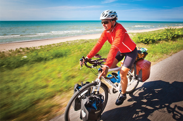
Photo by Adam Coppola
Generally the terrain is either rolling or flat.
| Florida Connector - Main Route | ||||
|---|---|---|---|---|
| Section | Distance | Elevation | Total Climb | Avg. Climb/mile |
| Total | 507.8 miles | Minimum: 0 ft.Maximum:220 ft. | 6,265 ft. south bound6,330 ft. north bound | 12 ft. per mi. south bound12 ft. per mi. north bound |
| Florida Connector Alternates | ||||
|---|---|---|---|---|
| Name | Section | Distance | Total Climb | Avg. Climb/mile |
| Ferry Spur | 1 | 12.2 miles | 60 ft. south bound75 ft. north bound | 5 ft. per mi. north bound6 ft. per mi. north bound |
Services are plentiful in the urban areas but can be scarce in residential/suburban and rural areas. This route may be ridden all year round. Caution: the hurricane season is from June 1 to November 30.
Some campgrounds will charge a cyclist traveling alone less if they have hiker/biker sites, but often they will charge the price of a regular tent site, and that can easily be $10-$20+/night. If you’re friendly and ask around, you can often get yourself invited to camp in a yard. Many small town city parks are free to camp in.
Route Highlights
Florida Connector Highlights
- St. Augustine
- Fort Matanzas National Monument
- Washington Oaks Gardens State Park
- De Leon Springs State Park
- Blue Spring State Park
- Walt Disney World
- Bok Tower Gardens
- Lake Okeechobee
More Route Resources
- U.S. Bicycle Route System
- U. S. Bicycle Route 1
- How to Travel on Amtrak with your Bicycle
- Flagler Beach to Marineland Trail
- Daytona Bike Week (motorcycle event)
- Spring-to-Spring Trail
- Cross Seminole Trail
- Seminole Wekiva Trail
- West Orange Trail
- Key West Express ferry
- Lake Okeechobee Scenic Trail
- Connect and share photos with other riders on Instagram: #acaFlConn
Updates to Recently Released Maps
If you are planning a bike tour, be sure to get the most recent map updates and corrections for your route by selecting the route, and the appropriate section(s), from the drop-down menu below.
Over time maps become less useful because things change. Every year Adventure Cycling’s Routes and Mapping Department create map updates and corrections for every map in the Adventure Cycling Route Network, which now totals 52,047 miles. With the help of touring cyclists like you, we receive updates on routing, services, camping, and contact information. Until we can reprint the map with the new information, we verify the suggested changes and publish corrections and updates here on our website.
PLEASE NOTE: Covid has been particularly hard on the small businesses along our routes. While we do our best to keep the maps and these online updates current, you may encounter more closed businesses and longer stretches with limited or no services.
Refer to these updates for the most current information we have and submit reports of changes to the Route Feedback Form for the cyclists coming after you.
NOTE: Map updates and corrections only pertain to long term changes and updates. For short term road closures, please see the Adventure Cycling’s Routes Temporary Road Closures discussion in our Forums.