Bicycle Route 66

Bicycle Route 66 Chicago, IL to Santa Monica, CA 6 Map Set GPX Data | Overview | Buy | Mobile App
1. Chicago, IL to St. Louis, MO Detail
2. St. Louis, MO to Joplin, MO Detail
3. Joplin, MO to Adrian, TX Detail
4. Adrian, TX to Gallup, NM Detail
5. Gallup, NM to Oatman, AZ Detail
6. Oatman, AZ to Santa Monica, CA Detail

Biking for Your Kicks on Bicycle Route 66

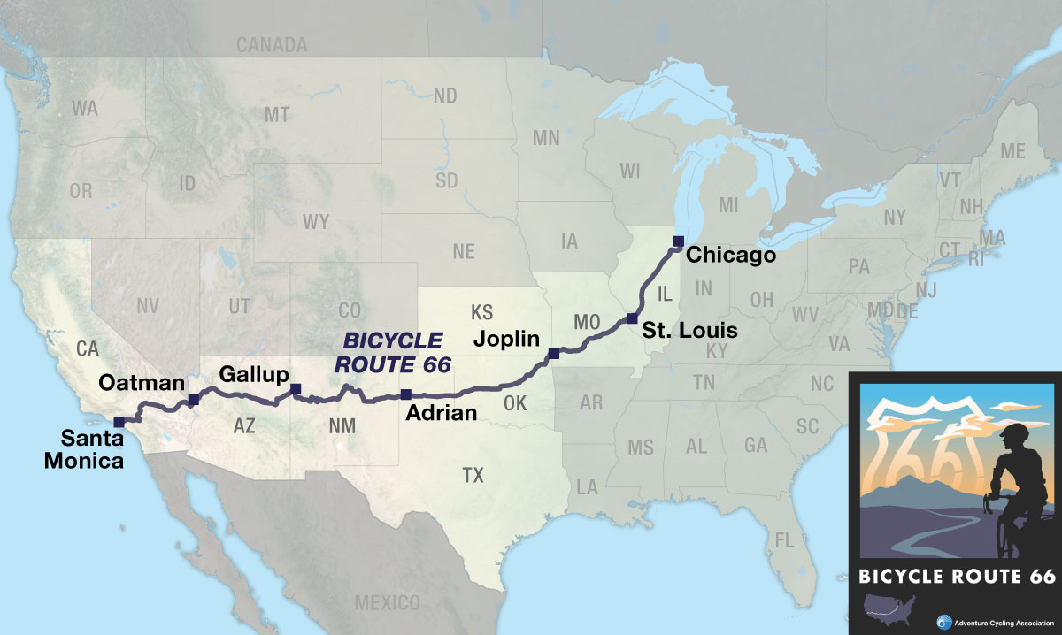
For over 50 years, motorists traveled the legendary U.S. Route 66 – popularly known as Route 66 or The Mother Road – from Chicago, Illinois to the Santa Monica Pier in Los Angeles, California. Now it’s the cyclists’ turn.

In view of the strong association between the historic roadway and America’s love affair with the automobile, it is perhaps ironic that hundreds of travelers will now attain independence from the motor vehicle by traveling Bicycle Route 66 under their own steam. While the cafes and grocery stores along the way remain important fuel stops for them, traveling cyclists can enjoy a certain satisfaction as they whiz past the many gas stations found in the towns and cities they visit.

Over the years Route 66 was in service there were multiple alignments of its path. Some of them exist today as Historic Route 66 and are signed in various ways. In many places Historic Route 66 was replaced by interstate highways. Bicycle Route 66 travels west on bike paths, county roads, and state, federal, and interstate highways. However, please note Bicycle Route 66 does not always follow Historic Route 66. Deviations were made based on present-day conditions.

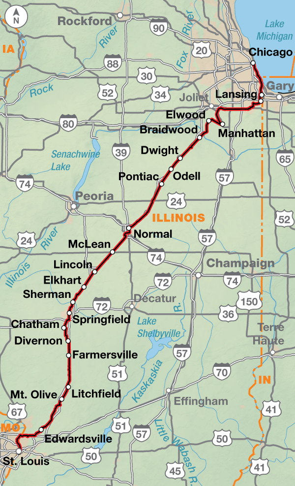
Right from the start in Chicago, Illinois, Bicycle Route 66 diverges from Historic Route 66 due to heavy traffic conditions. The official start location on Lake Michigan in Grant Park at Buckingham Fountain allows the use of multiple bike paths and trails along with city streets out of the congestion to meet up with Historic Route 66 in Elwood. A short distance later, the route begins its parallel path with I-55 passing through the capital city of Springfield as well as many smaller communities.

Much of the route in Illinois is characterized by the prairie landscape and rolling hills. In Madison County, the route takes advantage of a number of county-maintained trails to the Mississippi River crossing on the historic Chain of Rocks Bridge into St. Louis, Missouri.

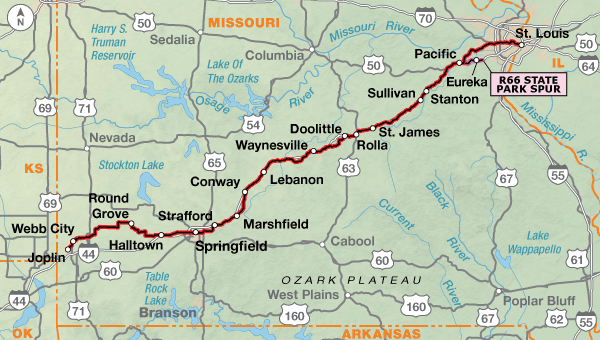
The Riverfront Trail leads cyclists into the city and past the Gateway Arch commemorating the launch of the Lewis & Clark Corps of Discovery Expedition. Once through the suburbs on city and county roads, Bicycle Route 66 begins paralleling I-44 mostly on frontage roads and some county highways. Not far out of St. Louis, cyclists will encounter the rolling hills of the northern reaches of the Ozark Mountains. West of Springfield, Missouri, the route leaves Historic 66 in favor of quieter county roads and state highways. Bicycle Route 66 rejoins Historic Route 66 east of Joplin.

Kansas contains only about a dozen miles of Route 66, the least of any of the eight states the highway runs through. That didn’t prevent the residents of the area from taking great pride in “owning” part of the highway.

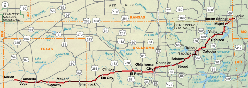
Once the route reaches the Oklahoma border, the flat to rolling landscape will encompass a variety of different prairie types until it reaches the Great Plains of the Texas panhandle. In general, the terrain across Oklahoma is a gradual uphill again paralleling interstates, first I-44, then I-40.

Amarillo, Texas is the last large city on the route before you reach the midpoint of Historic Route 66 in Adrian, Texas. Up to this point in the route, services of most types are regularly available and there are no extended sections of sparse services. However, the availability of bike shops decreases as the route heads west.

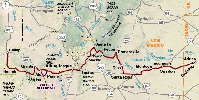
Much of Bicycle Route 66 across New Mexico is either on or roughly paralleling I-40 and/or I-25. One notable exception is where the route heads north to Santa Fe following an older alignment of Historic Route 66 before returning south to Albuquerque. Cyclists wishing a more direct route can opt to ride the shoulder of I-40 to Tijeras then return to the route. A second exception takes cyclists onto the Turquoise Trail/State Highway 14 between Santa Fe and Tijeras providing beautiful open vistas before returning to Historic Route 66.

West of Albuquerque to Chambers, Arizona and again past Flagstaff, Arizona, Bicycle Route 66 passes through several Native American lands known as Pueblos, Nations, and Reservations. These are sovereign lands with their own cultural flavor. Etiquette across them will require you to be a bit more circumspect in your behavior. Stealth camping is not permitted and in most, permission must be granted to photograph or otherwise record the scenery and sites. While most of the roads through these lands are state owned, those on the Pueblo Alternate through Acoma Pueblo are not and are subject to closures periodically. A visit to the Sky City Cultural Center and Haak’u Museum is a must if riding this 27.1 mile alternate.

Just west of Grants, New Mexico, cyclists will cross the Continental Divide as they pedal through the El Malpais National Monument. For a more direct route between Grants and Gallup, you can choose to follow I-40 and its frontage roads. This is the original alignment of Route 66.

Gallup, New Mexico is home to the Brickyard Bike Park, which celebrated its grand opening in September 2013, with cycling celebrity Levi Leipheimer officiating. The bike park, coupled with a 15-year-long effort to build trails outside of town and recast the city as a mountain-biking mecca, has earned Gallup a formal designation by the state legislature as the Adventure Capital of New Mexico. Today, the area boasts two major networks of professionally designed, curvy singletrack trails, including the flagship High Desert Trail. Gallup hosts more mountain bike races than any other community in New Mexico and the High Desert Trail system has been designated a National Recreation Trail.

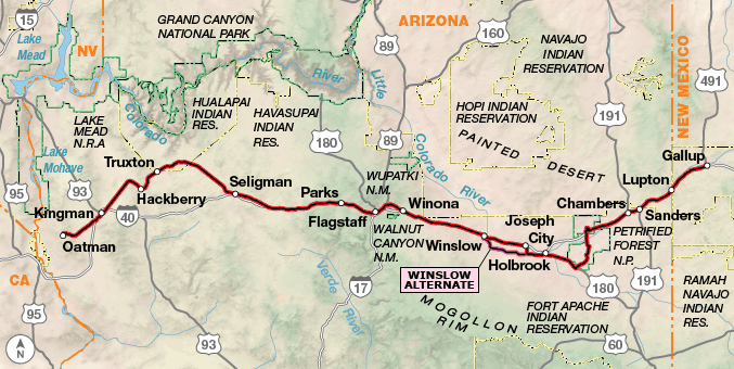
Bicycle Route 66 breaks from following Historic Route 66 to head south through the Petrified Forest National Park. Its hauntingly beautiful archaeological sites and unique geological formations include, not surprisingly, petrified trees.

In Flagstaff, Arizona you’ll see your first bike shop since Albuquerque. From Flagstaff, cyclists will ride a combination of I-40, paralleling service roads and county roads to Ash Fork before riding onto Old Route 66 the rest of the way across Arizona. From five miles south of Kingman to Topock at the California border, Old Route 66 has been designated by the Bureau of Land Management as the Historic Route 66 National Back Country Byway. It crosses Sitgreaves Pass in the rugged Black Mountains, where the BLM warns: “Travelers are advised that the portion of the highway passing through the mountains is a very narrow two-lane with no shoulders, extremely tight switchbacks, and many steep drop-offs.”

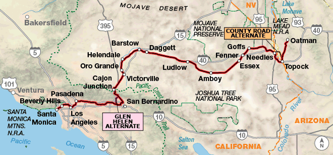
The entry into California drops cyclists into a long, desert stretch with very limited services from Needles to Barstow. This region is subject to violent thunderstorms and downpours in the summer monsoon and winter storm seasons. The weather pattern can result in flash flooding that closes the former Route 66 now known as the National Trails Highway (NTH) and thus Bicycle Route 66. Over the years the NTH has fallen into some disrepair and, in September 2014, a particularly bad storm system came through not only flooding the area but further damaging the NTH and several of the original Route 66 bridges causing long term closures of the road. However, there are long-term construction projects aimed at restoring the damaged portions. See advcy.link/sbtempclosures for road closures or inquire locally about conditions.

I-40 was built to replace the NTH. It is now the main thoroughfare between these two towns, and thankfully, has a well-maintained riding surface. While interstate riding is not our preference, it is the best solution to the problem of travel between Needles and Barstow if the NTH is impassable. Though I-40 is normally closed to bicycling, Adventure Cycling has worked with the California Department of Transportation (Caltrans) to come to an agreement about temporarily allowing cyclists to ride sections of I-40 to continue on Bicycle Route 66. (See the map updates and corrections for Bicycle Route 66, Section 6 for current detour information.)

Once out of the desert, services improve and traffic increases as the route becomes urban through the suburbs of Los Angeles. While there are several plaques in the area denoting the end of Historic Route 66, the terminus of Bicycle Route 66 is on the Santa Monica Pier at the sign located where the road meets the pier.

Photo by Michael Clark

This route contains a diversity of landscapes from the flat prairie grasslands of Illinois to the rolling hills of the northern reaches of the Ozark Mountains to the vast, open desert spreads across the southwest.

While there aren’t a lot of mountain passes on this route, across New Mexico, Arizona, and California there are long stretches across the desert with few services and significant heat depending on the time of year.

Bicycle Route 66 - Main Route
Section Distance Elevation Total Climb Avg. Climb/mile
Total 2517.6 miles Minimum: 0 ft.
Maximum:7900 ft.
88990 ft. west bound
89500 ft. east bound
35 ft. per mi. west bound
36 ft. per mi. east bound
1 339.9 miles Minimum: 400 ft.
Maximum:850 ft.
4480 ft. west bound
4665 ft. east bound
13 ft. per mi. west bound
14 ft. per mi. east bound
2 326.3 miles Minimum: 415 ft.
Maximum:1510 ft.
16415 ft. north bound
15765 ft. north bound
50 ft. per mi. north bound
48 ft. per mi. north bound
3 582.9 miles Minimum: 535 ft.
Maximum:4090 ft.
19440 ft. west bound
16550 ft. east bound
33 ft. per mi. west bound
28 ft. per mi. east bound
4 504.6 miles Minimum: 3765 ft.
Maximum:7900 ft.
23590 ft. west bound
21220 ft. east bound
47 ft. per mi. west bound
42 ft. per mi. east bound
5 404.5 miles Minimum: 2260 ft.
Maximum:7335 ft.
13200 ft. north bound
16955 ft. north bound
33 ft. per mi. north bound
42 ft. per mi. north bound
6 359.4 miles Minimum: 0 ft.
Maximum:4290 ft.
11865 ft. north bound
14345 ft. north bound
33 ft. per mi. north bound
40 ft. per mi. north bound
Bicycle Route 66 Alternates
Name Section Distance Total Climb Avg. Climb/mi
Route 66 State Park 2 9.8 miles 250 ft. east bound
265 ft. west bound
26 ft. per mi. east bound
27 ft. per mi. west bound
Pueblo Alternate 4 27.1 miles 1120 ft. west bound
850 ft. east bound
41 ft. per mi. west bound
31 ft. per mi. east bound
Winslow Alternate 5 26.7 miles 650 ft. north bound
955 ft. north bound
24 ft. per mi. north bound
36 ft. per mi. north bound
County Road Alternate 6 12.5 miles 205 ft. north bound
330 ft. north bound
16 ft. per mi. north bound
26 ft. per mi. north bound
Glen Helen Alternate 6 9.6 miles 210 ft. west bound
955 ft. east bound
22 ft. per mi. west bound
99 ft. per mi. east bound

For westbound riders this route is best ridden in spring with a departure in mid-April. This will allow most cyclists to make it through the highest humidities of the midwest and high heats of the desert before June through August. If departing in autumn, mid-August to September should allow cyclists to clear the mountains before heavy snows fall as well as avoid the heat and humidity. For eastbound riders starting in California, the best departure time is September.

Though the famous Route 66 song may indicate that you’d want to travel from Chicago to LA, based on general wind patterns, you’ll find them more in your favor if you ride eastbound, from Los Angeles to Chicago. Strong winds come from the west, southwest, and south during the riding season. The farther east you ride the winds come from the south, so about the time you begin angling to the northeast near Oklahoma City, the winds will be typically from the south-southwest.

While much of the route has plenty of food sources, riders should be prepared to carry food and water across some of the longer desert stretches in the Southwestern U.S. There are few bike shops from Amarillo, Texas until the outskirts of Los Angeles.

Some campgrounds will charge a cyclist traveling alone less if they have hiker/biker sites, but often they will charge the price of a regular tent or RV site, and that can easily be $10-$20/night. If you’re friendly and ask around, you can often get yourself invited to camp in a yard. In national forests you are allowed to camp anywhere on national forest land as long as you “pack it in, pack it out.” Many city parks are free to camp in.

You may also wish to sign up with Warmshowers, a reciprocal hospitality site for bicycle travelers, for other overnight options.

Route Highlights

  • Midewin National Tallgrass Prairie, Section 1
  • Lincoln Home National Memorial, Section 1
  • Chain of Rocks Bridge, Section 1
  • St. Louis, Missouri, Sections 1 and 2
  • Meremac State Park, Section 2
  • Route 66 State Park, Section 2
  • Ozark Mountains, Section 2
  • Ribbon Road, Section 3
  • Hometown of Mickey Mantle, Commerce, Oklahoma, Section 3
  • Hometown of Will Rogers, Claremore, Oklahoma, Section 3
  • The Blue Whale of Catoosa, Section 3
  • Slug Bug Ranch and Cadillac Ranch, Section 3
  • Glenrio, Texas, Section 4
  • Pecos National Historical Park, Section 4
  • Turquoise Trail, Section 4
  • El Malpais National Monument, Section 4
  • Navajo Nation, Sections 4 and 5
  • Petrified Forest, Section 5
  • Painted Desert, Section 5
  • Hualapai Native American Reservation, Section 5
  • Mojave National Preserve, Section 6
  • Mojave Desert, Section 6
  • San Gabriel Mountains, Section 6

More Route Resources

RIDING CONDITIONS

Note: Bicycle Route 66 does not always follow Historic Route 66. Deviations were made based on present-day conditions.

Bicycle Route 66 begins in downtown Chicago along Lake Michigan. You’ll be riding trails and city streets to make your way through the city and its suburbs. As with all cities, rush hours are to be avoided. Our route does not follow historic Route 66 to leave the city due to high traffic levels and safety concerns. For bike maps of Chicago and Illinois see: advcy.link/chicagobikemaps.

At Laraway Rd., south of Joliet, the Wauponsee Glacial Trail turns into a finely crushed gravel surface for 5.2 miles.

The riding through Illinois is over flat to rolling terrain that originally supported the tallgrass prairie ecosystem. Efforts to restore the native prairie can be seen along many roadsides today.

The shoulder on SR 53 between Elwood and Wilmington is minimal to non-existent and sometimes filled with litter when it exists. Traffic can be heavy and high speed. Caution advised. The Route 53 Trail through the Midewin National Tallgrass Prairie is unpaved, but provides a nice break from the busy highway.

Central Illinois is characterized by small towns and mid-sized cities with ample services. Springfield and Bloomington/Normal are the only cities of any size and present no unique problems to traverse. Instead of using major roads in many of the towns and cities, the route follows occasional bike paths and city streets.

Many miles of the route parallels I-55. When the interstate was built, U.S. 66 became I-55 so you’ll ride on multiple frontage roads.

The Green Diamond Rail Trail (not on the route) connects Farmersville and Waggoner, but it is unpaved and poorly maintained. Inquire locally about conditions before choosing to ride it.

Madison County is the last county in Illinois before riding into Missouri and the route uses several of the county trails. For occasional closures and more information see mcttrails.org.

The route crosses the Mississippi River into Missouri via the picturesque Chain of Rocks Bridge which is closed to motorized traffic. The Riverfront Trail travels along the Mississippi River through an industrial area to reach downtown St. Louis and the Gateway Arch. Plan your itinerary accordingly to avoid rush hours to get through the city and its suburbs. For a bike map of St. Louis, see advcy.link/stlouisbikemap.

All known Amtrak stations are listed on this map but not all stations provide bicycle service. Check if bicycle service is provided at both the starting and ending stations on your trip using the spreadsheet and other trip planning resources at advcy.link/amtrak.

USBR 36 has been designated in Illinois. Portions of our route run concurrent with it. For more information and maps see advcy.link/ilusbr. The route in Missouri is concurrent with USBR 66. As of this printing, it is planned to be signed. Be aware that signs can be damaged, stolen, or otherwise missing so you can never rely totally on following signs. For more information and maps see advcy.link/mousbr.

CLIMATE

Illinois has a humid continental climate with hot, wet summers, cold, snowy winters and frequent short fluctuations in temperature, humidity, and wind direction.

Illinois averages around 50 days of thunderstorm activity a year which puts it somewhat above average for the U.S. Nearly half of all thunderstorm days occur during the June-August period.

The flat plains of Illinois are favorable to tornado activity. An average of 35 occur annually, mainly in May. Their path of travel can be erratic. If you see one on the horizon, seek shelter below ground at a farmhouse, if at all possible. If not, find a ditch or low spot and wait out the storm.

Updated: Sep 28, 2020


RIDING CONDITIONS

Note: Bicycle Route 66 does not always follow Historic Route 66. Deviations were made based on present-day conditions.

St. Louis is the largest city on Route 66 between Chicago and Los Angeles. In St. Louis the route follows city streets that require extra vigilance. Chouteau Ave./SR 100 has bike lanes but can have heavy traffic; watch out for turning vehicles. Plan your itinerary accordingly to get through the city and its suburbs. Ride carefully and avoid rush hours.

For bike maps of St. Louis see: advcy.link/stlouisbikemap.

And for Springfield see: advcy.link/springfieldbikemap.

Missouri is hilly. Between St. Louis and Springfield, cyclists will encounter some bigger hills as you are riding through the northern reaches of the Ozark Mountains.

Overall, Missouri has 1,100 miles of waterways. Its numerous rivers give life to farms and lush vegetation, the hills carpeted by endless forests. These are the same rivers that forced Route 66 to cross numerous bridges, many of which you will also cross.

From St. Louis to Springfield there are ample services with usually less than 10 miles in between them. The route parallels I-44 following frontage roads and flipping back and forth from either side of the interstate. Local traffic uses these roads while the majority of the through traffic will be on I-44.

The route through Springfield is biker friendly. It’s still a good idea to avoid riding through the city during rush hours.

Between Springfield and Joplin, the route departs the Historic Route 66 corridor north of SR 96 in favor of several lesser traveled county and farm roads. All road surfaces have been confirmed as paved but there may be sections of poor maintenance and/or signage, and services are few. Note that SR 96 may be traveled west directly to Carthage but the highway carries significantly more traffic and has narrow shoulders.

The 9.8-mile Route 66 State Park Spur connects the Main Route with the historic park in Eureka.

U.S. Bicycle Route (USBR) 66 has been designated in Missouri. Portions of our route run concurrent with it. For more information and maps see advcy.link/mousbr.

All known Amtrak stations are listed on this map but not all stations provide bicycle service. Check if bicycle service is provided at both the starting and ending stations on your trip using the spreadsheet and other trip planning resources at advcy.link/amtrak.

CLIMATE

The continental climate of the state is subject to frequent changes. The three primary causes are (1) cold air moving down from the north, (2) warm, moist air entering from the Gulf of Mexico, and (3) dry air from the Plains sweeping in from the west.

In summer, the warm, moist air masses can produce copious amounts of rain, largely in the form of showers or thunderstorms. Spring and fall are transitional seasons when abrupt changes in temperature and precipitation may occur due to successive, fast-moving fronts.

Flash flooding along minor streams following heavy thunderstorms can occur frequently in the spring and early summer from April to July, but may occur during any month.

Tornadoes have been observed during every month of the year, with about 70% occurring from March through June. Their path of travel can be erratic. If you see one on the horizon, seek shelter belowground at a farmhouse, if at all possible. If not, find a ditch or low spot and wait out the storm.

Updated: Aug 9, 2021

RIDING CONDITIONS

Note: Bicycle Route 66 does not always follow Historic Route 66. Deviations were made based on present-day conditions.

Missouri State Parks have a no-turn-away policy which can be found at advcy.link/noturnaway.

You’ll encounter both flat terrain and rolling hills on this section of Bicycle Route 66. Oklahoma tends to slope gradually upward from its eastern to western boundaries. Woodlands and transitional prairie grasslands, composed of shortgrass, mixed-grass, and tallgrass prairie cover the central portion of the state. In the upper portion of Texas, referred to as the Panhandle, the Great Plains become a reality in the flat, wide open expanse of country you’ll ride through.

The route parallels I-44 between the Kansas border and Oklahoma City, then uses multiple frontage roads along I-40 between Oklahoma City and Adrian. These roads can go by several names including: service road, outer road, frontage road, etc. There are miles where you will ride on the interstate’s shoulder. Watch for debris and use caution when crossing on and off ramps at the exits.

U.S. Bicycle Route (USBR) 66 is designated but not signed in Missouri, and is signed throughout Kansas. Our routing is not always concurrent with USBRs. For more information and maps see advcy.linkmousbr and advcy.link/ksurbr. Be aware that signs can be damaged, stolen, or otherwise missing so you can never rely totally on following signs.

Services are reasonably spaced with Tulsa, Oklahoma City, and Amarillo offering full services and bike shops. Bike shop availability decreases the farther west you ride so stock up if you need tubes and other miscellaneous parts.

The 12.9 miles of the route in Kansas retains much of the character of the Mother Road.

Between Claremore and Catoosa, our route avoids Historic Rte. 66 due to a lack of shoulders when heading westbound.

You’ll ride through Tulsa mostly on a main thoroughfare, and the Riverparks East Trail, advcy.link/rvrparkseasttrl. Ride defensively and try to avoid the morning and evening commute hours. For a map of Tulsa regional trails see advcy.link/tulsaregtrls.

Be careful while riding on SR 66 near Arcadia Lake. The road is busy and has limited shoulders. The Rte. 66 Trail, advcy.link/rte66trl, goes through Central State Park.

Plan your itinerary accordingly to avoid riding through Oklahoma City and its suburbs during rush hours. The city streets are busy with little or no shoulders. Information on multi-use trails in Oklahoma City found at advcy.link/okctrls.

The city of Bethany suggests that cyclists take an alternate route along NW 39th Street between 7:00 – 9:00 a.m. and 4:00 – 6:00 p.m. on weekdays to avoid heavy traffic.

In Amarillo, most of the route could be ridden safely even during rush hours, but will still be safer outside of those times. The biggest concern is multiple viaducts in the city that allow vehicle traffic to avoid the many railroad tracks scattered all over town. Most of these viaducts are signed “No Bicycles”. The route we’ve chosen avoids most viaducts and/or provides an alternative route for cyclists below the viaduct. A map of bicycle routes can be found at: advcy.link/amarllobikemap.

West of Amarillo the route is on roads that parallel the interstate. In this area, these roads are of decent quality and the traffic is very low. These service roads constantly go from the north to the south side of the interstate, and then back again.

All known Amtrak stations are listed on this map but not all stations provide bicycle service. Check if bicycle service is provided at both the starting and ending stations on your trip using the spreadsheet and other trip planning resources at advcy.link/amtrak.

CLIMATE

Oklahoma’s climate ranges from humid subtropical in the east to semiarid in the west. Warm, moist air moving northward from the Gulf of Mexico often exerts influence, particularly over the southern and eastern portions of the state, where humidity, cloudiness and precipitation are greater than in western and northern sections. Summers are long and quite hot. Late spring and early summer are the peak for thunderstorms.

Tornadoes are a particular hazard in Oklahoma and the Texas Panhandle. They usually hit during April, May, and June.

The Texas Panhandle’s climate is semiarid with hot summers and many clear days.

Updated: Aug 12, 2021


RIDING CONDITIONS

Note: Bicycle Route 66 does not always follow Historic Route 66. Deviations were made based on present-day conditions.

Wide open space is the theme across west Texas and New Mexico with semiarid landscapes and generally long distances between services. Shoulder widths vary on I-40 and I-25 and contain rumble strips and road debris. Be aware that local roads and county roads are subject to flash flooding from July through September.

Services are very limited for the 63.4 miles between Tucumcari and Santa Rosa and 97.2 miles between Santa Rosa and Pecos. Cuervo Rd. is washed out in some short sections and may be dusty and in poor condition; use caution when wet. The alternative is to use I-40.

To ride a more direct route to Albuquerque (roughly along the post-1937 alignment of Route 66), westbound riders can continue on the I-40 shoulder at Exit #256. Exit I-40 at Moriarty and continue onto SR 333 which connects back to route at the junction of SR 14 and SR 333 near Tijeras. This shortcut is about 82 miles, 79 miles shorter than the main route. Elevation will increase until Clines Corners and again east of Tijeras passing between the Manzano and Sandia Mountains. Services and local traffic increase from Moriarty to Albuquerque.

The route into Santa Fe roughly follows a pre-1937 alignment of Route 66. It is longer but has less interstate riding, fantastic views, and a more authentic Route 66 feel including a jaunt by the historic plaza. U.S. 84’s shoulder is good to fair while the elevation increases approaching I-25. Plan on traffic and the elevation increase again through the Sangre de Cristo Mountains into Santa Fe.

Expect high traffic and urban riding through Santa Fe except along the Santa Fe Rail Trail and the Arroyo de los Chamisos Trail. Trail conditions vary from smooth to rough pavement. The Arroyo de los Chamisos Trail is prone to flash flooding July through September. A Santa Fe bicycle map is available at: advcy.link/SantaFeBikeMap.

Leaving Santa Fe on SR 14, expect increased climbing with variable shoulder widths until Madrid. The shoulder disappears after Madrid where a long and narrow climb begins. The shoulder reappears and the traffic increases at San Antonito. Use extreme caution on the long descent to the intersection where SR 14 connects to SR 333 under I-40. Traffic increases significantly on SR 333.

The ride along the Turquoise Trail road between Santa Fe and Tijeras provides beautiful open vistas. But if you are in a hurry, the Railrunner train can take you and your bicycle between Santa Fe and Albuquerque. See advcy.link/RailRunner for more information.

Plan on urban traffic and road conditions through Albuquerque except on the multi-use trail sections. On multi-use trails you will encounter heavy pedestrian and local cycling traffic. The Rio Grande bisects Albuquerque, therefore it is downhill to the river and uphill after crossing it.

West of Albuquerque, the route goes through portions of Laguna and Acoma Pueblos. Please read “Etiquette & Rules for Riding Across Native American Lands”.

The main route to Grants follows Historic Route 66. Riding the 27.1-mile Pueblo Alternate adds about 13 miles to the Main Route. This alternate route is subject to closure without notice. Annual closures include dates in June, July, August, and December. It is recommended that you contact the Pueblo before taking this alternate.

For a more direct route between Grants and Gallup, you can choose to follow I-40 and its frontage roads. This is the original alignment of Route 66.

SR 53 and SR 602 have varying shoulder widths and conditions with limited services. Be respectful passing through Zuni Pueblo. Local traffic increases as you enter Gallup.

Cell service is generally good with pockets of no service in more remote areas, generally away from the interstates. Many of the all service towns have convenience stores rather than groceries. Bike shops are almost nonexistent on this map section and can only be found in Santa Fe and Albuquerque.

All known Amtrak stations are listed on this map but not all stations provide bicycle service. Check if bicycle service is provided at both the starting and ending stations on your trip using the spreadsheet and other trip planning resources at advcy.link/amtrak.

Etiquette & Rules for Riding across NATIVE AMERICAN Lands

Pueblos and Reservations are sovereign nations administered by tribal governments. As guests crossing tribal lands, please behave accordingly.

  • Stay on the designated route. Off-road sightseeing, camping, and rock climbing are strictly prohibited.
  • Camping is prohibited on tribal land except in developed campgrounds operated by the Pueblos. A permit is required to camp on the Navajo Nation, contact the Navajo Parks and Recreation office 3-4 weeks in advance, 928-871-6647.
  • Photography, filming, video recording, audio recording, sketching, or any other form of recording images or sound is prohibited without first gaining consent, and possibly paying a fee or applying for a permit, from each Pueblo or Nation. Commercial use of recorded images or sounds is prohibited. VIOLATORS OF THESE GUIDELINES WILL HAVE THEIR FILM AND/OR CAMERA CONFISCATED.
  • Check with Tribal officials BEFORE entering any churches, residences, ruins, ceremonial places, and/or any other structures.
  • Most Pueblos require visitors to register for guided tours.
  • If organized tours are offered, stay with your tribal guide at all times.
  • Alcoholic beverages, illegal drugs, smoking, and firearms are prohibited.
  • Do not pick up or remove ANY artifacts, pottery shards, or any other items.
  • Observe all posted restrictions.

CLIMATE

The climate of New Mexico is generally semiarid to arid, though there are areas of continental and alpine climates.

April, May, June, and early July are typically dry. There is a windy season, usually from late March to early April, when strong westerly winds scour the state with dust and grit.

The wettest months are July, August, and early September. This is New Mexico’s “monsoon season”, when moisture-laden tropical air triggers frequent, and sometimes violent, afternoon thunderstorms. Lightning associated with these makes summits and ridges especially dangerous, and flash flooding makes camping in dry watercourses unwise.

Updated: Dec 18, 2020

RIDING CONDITIONS

Note: Bicycle Route 66 does not always follow Historic Route 66. Deviations were made based on present-day conditions.

Between Gallup, New Mexico and Oatman, Arizona the country is open and semiarid; there are generally long distances between services provided by the few trading posts along I-40. Traffic on I-40 is fast and can be heavy due to it being a major east/west truck route. Shoulders are generally wide with well-placed rumble strips, but conditions may vary. Watch for road debris on the interstate. Local road conditions vary, contain numerous cattleguards and are subject to flash flooding from July through September.

Most parts of Arizona do not observe Daylight Saving Time, but rather use Mountain Standard Time all year long. The exception is the Navajo Nation. Between Gallup and Chambers the route crosses the Navajo Nation and is subject to the rules and regulations of both the U.S. and the Nation. Stay on the route, act respectfully and do not camp on Reservation land. For information see www.discovernavajo.com or call 928-810-8501.

Ride carefully on the frontage road west of Lupton due to deteriorating pavement.

Near and in any national park cyclists will have to contend with higher traffic levels and RV drivers who are inexperienced. The Petrified Forest National Park offers a welcome diversion from riding the shoulder of I-40. The road through the park is open 8 AM – 5 PM year round, with extended hours as staffing permits, so you can’t ride early in the morning or later in the day. Be aware there is no developed campground or lodging in the Park. Contact the Painted Desert Visitors Center for seasonal hours and water availability at: advcy.link/petforestnp or call 928-524-6228.

For a shorter alternate of 24.6 miles, you could stay on I-40 until Exit #289, taking Navajo Blvd. into Holbrook. There are limited services.

The main route goes through the southern edge of Holbrook and continues on local roads to Joseph City, then follows I-40 to Winslow. South of Joseph City, the 26.7-mile Winslow Alternate includes 19.1miles of deteriorating dirt road which is generally hard-packed but subject to flash flooding July through September. Avoid it when it’s wet. Do not ride this if you are on narrow tires. There are no services on the alternate.

To the west of Exit #230, the I-40 bridge crossing of Diablo Canyon has very narrow shoulders. Proceed with extreme caution.

Exiting I-40 at Winona onto unsigned Townsend-Winona Rd./Old Route 66 the shoulder is limited and good to fair. In general, the road is rough and the elevation and traffic increases between Winona and Flagstaff.

U.S. 89 into Flagstaff has variable shoulder widths. Expect more traffic and urban riding through town. The bike path to downtown Flagstaff is concrete with regular horizontal seams, and looks like a wide sidewalk. However, the shoulder of U.S. 89 disappears in a few spots on the highway so if you choose to ride it, use caution. A Flagstaff trails and bikeways map is available at: advcy.link/flagstaffbikemap.

Another diversion from I-40 is to take Branigan Park Rd./Historic Route 66 between Exit #185 and Parks (Exit #178). This inlcudes 3.1 miles of gravel/dirt. Avoid it if it’s been raining.

Eastbound, the I-40 shoulder heading into Williams and between Exit #165 and Flagstaff has cracked and broken pavement.The roads through Williams vary but tend to be cracked; please ride with caution.

Towns increase in frequency west of Flagstaff with services between 10-50 miles apart until Kingman. Five miles past Ash Fork the route departs I-40 onto Old Route 66. There are no shoulders on Old Route 66 until 9 miles north of Kingman, but there is little traffic. You will ride through 16 miles of the Hualapai Reservation, which is subject to different rules and regulations than the state of Arizona. Stay on the route and act respectfully. Permits are necessary to camp on Reservation land and can be found at the Tribal Game and Fish office, 863 SR 66, Peach Springs, 928-769-2227 during business hours from 8 – 5 weekdays and 8 – noon Saturdays. Permits are a minimum of $32.50/day/person.

Traffic and services increase through Kingman. Leaving Kingman on Historic Route 66 there are no shoulders or guardrails, and fast local traffic. You can ride I-40 between Exit #48 (U.S. 93) and Exit #44 (Shinarump Rd.) to avoid this road section. From Exit #44 to Oatman there is gradual climbing across the basin for approximately 15 miles. It is followed by 9 miles of steep, narrow ascents around switchbacks to the expansive Sitgreaves Pass before winding downhill into Oatman. In town you can enjoy a trip back to the Old West but don’t feed the wild burros — they’ve been known to follow and harass bicyclists.

To avoid the steep, narrow climb over Sitgreaves Pass, or if Oatman Hwy. is closed due of flooding, you may take I-40 from Kingman (where the main route crosses I-40) to Exit #1, and rejoin the main route on Route 66, Section 6, map 91. This alternate is 44 miles, with no lodging between Kingman and Topock, but with convenience stores no further than 20 miles apart. Shoulders are wide, though conditions may vary. For road closure information due to flooding in Mohave County, Arizona, either check this website: advcy.link/mohavecounty or call 928-757-0910 during business hours.

All known Amtrak stations are listed on this map but not all stations provide bicycle service. Check if bicycle service is provided at both the starting and ending stations on your trip using the spreadsheet and other trip planning resources at advcy.link/amtrak.

CLIMATE

Arizona’s climate is dry with little rainfall. The northern part of the state has moderate summer temperatures.

The monsoon season begins in July when moist southerly winds bring thunderstorm activity. The short-lived, intense thunderstorms often result in flash flooding in steep terrain, as well as urban flooding through low-lying roads and normally dry washes.

Flash floods can occur anytime and are extremely dangerous due to their quick currents and tall waves. Do not approach running water such as streams or canals. The water level can rise dramatically within seconds. Stay on your side of the stream until the flow decreases.

Updated: Apr 7, 2020


RIDING CONDITIONS

Note: Bicycle Route 66 does not always follow Historic Route 66. Deviations were made based on present-day conditions.

This section contains some of the most isolated stretches and some of the busiest urban stretches of any Adventure Cycling route. Plan to carry extra provisions through the Mojave Desert between Needles and Barstow. There are two summits to cross — Cadiz Summit and Cajon Summit.

Be aware that local and county roads from Oatman, Arizona to San Bernardino, California are subject to flash flooding during the summer monsoon or winter storms. For road closure information in Mohave County, Arizona, check this website: twitter.com/mohaveroads, or call 928-757-0910 during business hours. For road closure information in San Bernardino County check this website: advcy.link/sbclosures or call 909-387-8063 during business hours.

The 12.5-mile County Road Alternate provides off-interstate riding, but note that the county roads have no shoulder and CR 1 has blind turns. When traffic is steady, usually between 7 AM and 6 PM, use caution. This alternate crosses the Fort Mojave Indian Reservation, which is subject to different rules and regulations than the state of Arizona. Stay on the route and act respectfully. For more information see fortmojaveindiantribe.com or call 760-629-4591.

Along I-40, 5.5 miles after crossing into California, there is a border protection station. Plant materials, including fruits and vegetables, will be checked for compliance with quarantine regulations.

Temperatures in the desert can be extremely high and water very limited between Needles and Barstow. Water and snacks can be found at convenience stores along the way, but there is no lodging for 108 miles between Needles and Ludlow. Primitive camping is allowed in some places, but we suggest getting permission to camp at a convenience store or on someone’s land. There can be unfriendly transients in these remote areas.

The National Trails Hwy. between Ludlow and Newberry Springs has a badly degraded surface and is VERY rough, although some portions appear to have been recently repaved. Secure any loose items and bolts on your bike. Allow considerable extra time to get through this stretch. For possible road closures call 909-387-8063.

At Cajon Junction, the shoulder disappears where on-ramps and off-ramps connect to I-15. You may wish to exit and then re-enter I-15 at Exit #131 to avoid this situation.

There is a 5.3-mile alternate that can be taken to get around most of the riding on I-15 south of Victorville. 2.9 miles are on rough dirt and the remainder is on State Highway 138. It is 0.6 miles shorter for westbound riders, and 0.2 miles shorter for eastbound riders than the main route. Use caution because parts of it are loose and steep. Do not use it when wet. See advcy.link/cajondirtaltmap for a map and advcy.link/cajondirtalt for a description of its historical context for Route 66.

The 9.6-mile Glen Helen Alternate is 8.8 mi. shorter than the main route and provides a quieter ride, but travels away from Route 66.

Expect urban riding conditions from San Bernardino to Santa Monica, with increasing traffic levels as you head west. The route avoids some of this traffic using 20 miles of the Pacific Electric Rail Trail from Rialto to Claremont. Riding the miles from Pasadena to Santa Monica on an early Sunday morning can help also. Please remember to be alert, careful about locking your bike, and don’t ride after dark in the cities. For Los Angeles area bike maps see: advcy.link/labikemaps.

All known Amtrak stations are listed on this map but not all stations provide bicycle service. Check if bicycle service is provided at both the starting and ending stations on your trip using the spreadsheet and other trip planning resources at advcy.link/amtrak.

CLIMATE

California’s climate varies widely. The southeast region has a hot, arid climate. The coastal and southern areas have a Mediterranean climate. In the Los Angeles Basin, the ocean’s influence moderates temperature extremes, especially along the coast.

In the Mojave Desert, summer is dominated by heat. Temperatures on valley floors can soar above 120°F. Low humidity, high temperatures, and low pressure draw in moisture from the Gulf of Mexico creating monsoonal thunderstorms from mid-June through early September. Autumn is generally pleasant and October is one of the driest and sunniest months.

After temperature, wind is the most significant weather phenomenon in the Mojave. Windy days are common; especially near the transition between the Mojave and the low valleys near Cajon Pass. The Santa Ana winds are strong, extremely dry winds that characteristically sweep into the Los Angeles Basin late fall into winter. They range from hot to cold, depending on prevailing temperatures in the desert.

Updated: Sep 28, 2020

Updates to Recently Released Maps

If you are planning a bike tour, be sure to get the most recent map updates and corrections for your route by selecting the route, and the appropriate section(s), from the drop-down menu below.

Over time maps become less useful because things change. Every year Adventure Cycling’s Routes and Mapping Department create map updates and corrections for every map in the Adventure Cycling Route Network, which now totals 52,047 miles. With the help of touring cyclists like you, we receive updates on routing, services, camping, and contact information. Until we can reprint the map with the new information, we verify the suggested changes and publish corrections and updates here on our website.

PLEASE NOTE: Covid has been particularly hard on the small businesses along our routes. While we do our best to keep the maps and these online updates current, you may encounter more closed businesses and longer stretches with limited or no services.

Refer to these updates for the most current information we have and submit reports of changes to the Route Feedback Form for the cyclists coming after you.

NOTE: Map updates and corrections only pertain to long term changes and updates. For short term road closures, please see the Adventure Cycling’s Routes Temporary Road Closures discussion in our Forums.