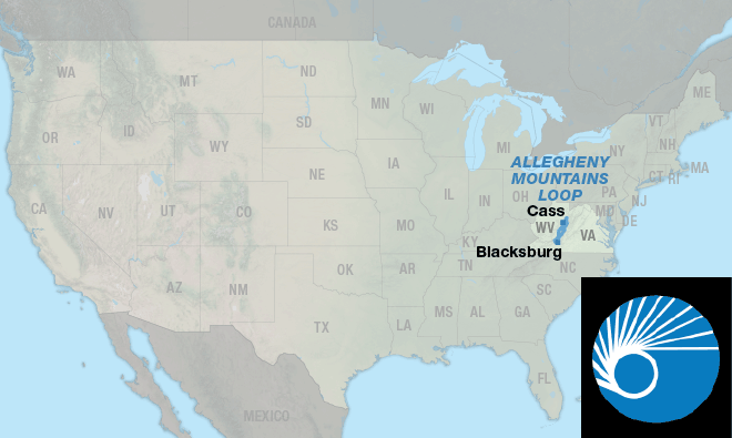
Allegheny Mountains Loop
| Allegheny Mountains Loop | GPX Data | Overview | Buy | Mobile App |
|---|---|
| 1. Blacksburg, VA to Blacksburg, VA | Detail |
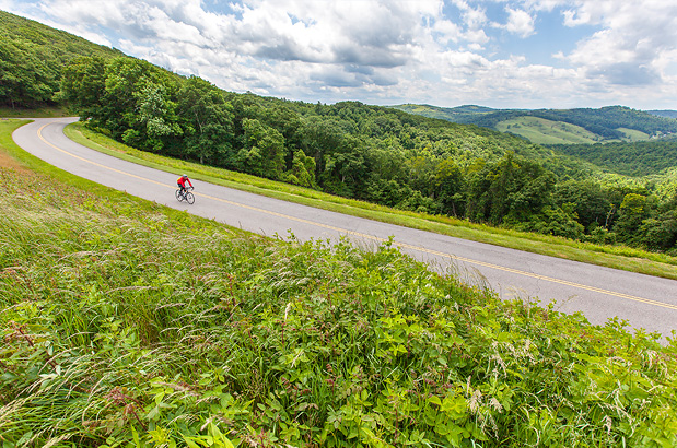
Variety defines this beautiful loop route.
The Allegheny Mountains Loop offers a wide variety of riding types — from pavement to gravel, from gentle grades along river valleys to steep, muscle burning climbs and fast descents over ridges, and from busy U.S. highways to lightly trafficked county roads and rail-trails where no cars are allowed. Besides the main route there are 3 options which give the cyclist alternatives in how much mileage they want to ride. Two of the options are cut-offs to shorten the main loop. The route begins and ends in Blacksburg, Virginia, and crosses back and forth between Virginia and West Virginia several times.
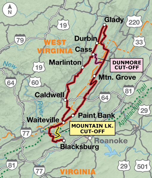
Blacksburg, located in the southwest corner of Virginia, is near the TransAmerica Trail. The largest city nearby, Roanoke, is 40 miles away. The route begins and ends with hills along the New River before heading into the first of many remote valleys cyclists will encounter in Virginia. Our meandering route avoids U.S. 460 as much as possible between Blacksburg and Pembroke. Just past Waiteville, riders will make a choice to follow the remainder of the route in a clockwise or counter-clockwise direction. The following description is written in the counter-clockwise direction.
The route heads northeast through quiet valleys and over smaller ridges on very lightly trafficked county roads. Portions of these roads are gravel, so using a bike with wider tires is recommended for this route. Expect more traffic, especially on weekends, in the Lake Moomaw and Bolar Mountain Recreation areas.
The main route continues on to Mountain Grove. North of Mountain Grove, cyclists will have the first choice of two cut-off options. The 24.5-mile Dunmore Cut-Off heads west on a state highway, goes up and over a major ridge into West Virginia, and ends in Cass.
An interesting place to visit is the Green Bank Observatory. The site is off route north of Dunmore or south of Bartow on State Hwy. 28/92. It is home to the 328 ft. Green Bank Telescope, the largest movable radio dish in the world. The center lies within the country’s only federal radio-free zone, which is why you won’t pick up any stations within 25 miles of the center.
The main route continues northeast to U.S. 250, where it heads west up and over another ridge top into West Virginia. After 3.7 miles on U.S. 250, the route follows Old Pike Rd./CR 3 to avoid U.S. 250 to Bartow. All the highways used on this route have minimal to no shoulders, and most are winding with short sight lines, especially when climbing or descending the ridges. We’ve tried to minimize use of these highways, but to get from one valley to the next they are often the only roads available. Please ride cautiously and wear bright clothing to be seen.
Another shortcut is the westward 2-mile Durbin Cut-Off that ends just north of Durbin, West Virginia. The next 52.8 miles of the main route uses gravel U.S.F.S. roads in the Monongahela National Forest. This is the most remote area along the route, and traffic will be minimal. The scenic beauty includes wildflowers in the spring and summer, and foliage colors in the fall. Durbin is home to the Durbin and Greenbrier Valley Railroad, which hosts four separate excursion trains leaving from various locations in the area.
South of Durbin is Cass, the home of Cass Scenic Railroad State Park, and the start of the 78-mile Greenbrier River Trail, the state’s longest rail trail conversion. The Park runs a steam logging locomotive train for visitors that terminates just below Bald Knob, elevation 4,832 feet, which is one of the highest summits in West Virginia. There is also a museum and overnight lodging is offered in restored former West Virginia Pulp and Paper Company cottages which were homes for its employees.
The route follows the entire length of the Greenbrier River Trail. The majority of the Trail is packed gravel, though about 5 miles have been paved near Marlinton. There is access to several towns for services such as groceries. Primitive campsites, drinking water, and restrooms are available on the Trail.
After the Trail ends the route uses a short stretch of U.S. 60 before heading south on remote county roads that wind over several smaller ridges and through woods, fields, and farmland. You will close the loop near Waiteville, and return south back the way you began. There is one more decision to be made seven miles south of Waiteville — instead of returning the way you came, you can choose the 24-mile Mountain Lake Cut-Off. It’s gravel up to the ridge top and down to Mountain Lake, then paved the remainder of the Cut-Off until rejoining the main route. It passes the Mountain Lake Lodge, where the movie “Dirty Dancing” was filmed.
Services are available in the larger towns near to the route, but groceries will be limited to mostly convenience stores on route. There are a few stretches with no services, so plan accordingly. Some cyclists may want to do this route during the colors of autumn. If you do, call ahead to verify campgrounds are open because some may close after Labor Day. If staying indoors, or at campgrounds, advance reservations are recommended, especially on weekends.
Photo by Dennis Coello
This part of Virginia and West Virginia is hilly! You’ll go from gentle grades along river valleys to steep, muscle burning climbs and fast descents over mountain ridges. The Greenbrier River Trail, a rail trail conversion, has almost nonexistent grades along the Greenbrier River.
| Allegheny Mountains Loop - Main Route | ||||
|---|---|---|---|---|
| Section | Distance | Elevation | Total Climb | Avg. Climb/mile |
| Total | 409.6 miles | Minimum: 1,300 ft.Maximum:4,390 ft. | 33,290 ft. counterclockwise33,090 ft. clockwise | 81 ft. per mi. counterclockwise81 ft. per mi. clockwise |
| Allegheny Mountains Loop Alternates | ||||
|---|---|---|---|---|
| Name | Section | Distance | Total Climb | Avg. Climb/mi |
| Mountain Lake Cuttoff | 1 | 24.0 miles | 2,510 ft. south bound3,580 ft. north bound | 105 ft. per mi. south bound149 ft. per mi. north bound |
| Dunmore Cutoff | 1 | 24 miles | 2,510 ft. west bound3580 ft. east bound | 105 ft. per mi. west bound149 ft. per mi. east bound |
| Durbin Cuttoff | 1 | 2 miles | 55 ft. west bound90 ft. east bound | 28 ft. per mi. west bound40 ft. per mi. east bound |
This route can be ridden anytime between late spring to late fall (typically April to mid-September). Services are available in the larger towns near to the route, but groceries will be limited to mostly convenience stores on route. There are a few stretches with no services, so plan accordingly. Some cyclists may want to do this route during the colors of autumn. If you do, call ahead to verify campgrounds are open because some may close after Labor Day. If staying indoors, or at campgrounds, advance reservations are recommended, especially on weekends.
The route follows the entire length of the Greenbrier River Trail. There is access to several towns for services such as groceries. Primitive campsites, drinking water, and restrooms are available on the Trail. For a free trail map that shows exact locations of amenities call the West Virginia State Parks at 833-987-2757 or see advcy.link/GreenbrierRivTrl. Maps are also available from the Pocahontas County Convention and Visitors Bureau at 304-799-4636 or advcy.link/PocahontasCo.
Some campgrounds will charge a cyclist traveling alone less if they have hiker/biker sites, but often they will charge the price of a regular tent or RV site, and that can easily be $10-$30/night. If you’re friendly and ask around, you can often get yourself invited to camp in a yard. Our routes sometimes go through national forests (moreso in the west) and you are allowed to camp anywhere on national forest land as long as you “pack it in, pack it out.” Many city parks are free to camp in.
You may also wish to sign up with Warmshowers, a reciprocal hospitality site for bicycle travelers, for other overnight options.
Route Highlights
Allegheny Mountains Loop Highlights
- Humpback Bridge (Virginia)
- Green Bank Observatory (West Virginia)
- Durbin and Greenbrier Valley Railroad (West Virginia)
- Cass Scenic Railroad State Park (West Virginia)
- Droop Mountain Battlefield State Park (West Virginia)
- Pearl S. Buck Birthplace (West Virginia)
- Mountain Lake Lodge (Virginia)
More Route Resources
- No-Turn-Away Bike Camping Policies (Virginia)
- Greenbrier River Trail (West Virginia State Parks)
- Tangent Outfitters (vehicle overnight location)
- Pocahontas County Convention and Visitors Bureau (West Virginia)
- Connect and share photos with other riders on Instagram: #acaAlleghMtns
Updates to Recently Released Maps
If you are planning a bike tour, be sure to get the most recent map updates and corrections for your route by selecting the route, and the appropriate section(s), from the drop-down menu below.
Over time maps become less useful because things change. Every year Adventure Cycling’s Routes and Mapping Department create map updates and corrections for every map in the Adventure Cycling Route Network, which now totals 52,047 miles. With the help of touring cyclists like you, we receive updates on routing, services, camping, and contact information. Until we can reprint the map with the new information, we verify the suggested changes and publish corrections and updates here on our website.
PLEASE NOTE: Covid has been particularly hard on the small businesses along our routes. While we do our best to keep the maps and these online updates current, you may encounter more closed businesses and longer stretches with limited or no services.
Refer to these updates for the most current information we have and submit reports of changes to the Route Feedback Form for the cyclists coming after you.
NOTE: Map updates and corrections only pertain to long term changes and updates. For short term road closures, please see the Adventure Cycling’s Routes Temporary Road Closures discussion in our Forums.