The Genesis of the Great Divide
Tour Divide racers ride the roller coaster of emotions as they hammer the 2,700 miles separating Banff and Antelope Wells. I know this from 1. talking to racers firsthand, 2. reading and listening to mid-race reports, 3. screening the film Ride the Divide, and 4. extrapolation of personal history. Having been a marathon runner and cross-country skier myself, I’ve experienced what it can take, mentally and physically, to push yourself to the limits for just two and a half or three hours — never mind two and a half or three weeks.
Like a Tour Divide racer, I teetered and tottered up and down the most radical carnival ride imaginable during the two and a half to three years it took to plan, research, and map the Great Divide Mountain Bike Route. My feelings ranged from moments of dread to hope to pure joy.
The following are some examples of what I’m talking about.
Inspiration
On July 20, 1985, my old college buddy Ramon, a Wyoming geologist, dropped my wife Nancy and me off at the Tri-Basin Divide in southwest Wyoming. That’s the point where water flows either toward the Colorado River, the Columbia River, or the Great Basin. There we grabbed our Cannondale mountain bikes — they were the first two Cannondale fat-tire bikes sold at the dealer in Missoula, Montana — out of Ramon’s truck and loaded them with way too much gear, all packed into (or on top of) rear-mounted panniers. Then we struck out on a five-day camping trip, riding on dirt roads and trails through the Wyoming and Salt River ranges, up the valley of the Green River, and along the Gros Ventre River from its headwaters to where it flows into the Snake River in Jackson Hole. The trip was hard, fun, and a real adventure. I knew I had found a new favorite pursuit — no, a new passion.
Flash forward nine years. In the July 1994 Adventure Cyclist — the magazine’s name had been changed from BikeReport just weeks earlier — we ran a two-page spread, written by yours truly, under the bold headline, “Ready for the Longest Mountain Bike Trail in the World?”
“Imagine mountain biking from Canada to Mexico, through some of the most stunning landscapes on earth,” the piece began, “along dirt roads and two-tracks reserved for the occasional fisherman’s rig, Forest Service pickup truck … and Adventure Cycling mountain biker.”
In the story, I explained the origin of our dream of an off-pavement route paralleling the Continental Divide and why we wanted to make it happen: “Historically, cycling enthusiasts have done one or the other — either loaded up with panniers and camping gear, that is, and lit out on the open road, or headed into the hills on a mountain bike for a day’s ride on dirt. Very few have toured off-pavement carrying a full complement of gear. We want to change that.”
Appreciation for Those Who Came Before
I’ve written before that the Great Divide might never have happened were it not for the late Mike and Dan Moe of Laramie, Wyoming, brothers who completed a pioneer hike-a-bike adventure along the Continental Divide in 1984.
Other individuals provided inspiration as well — for instance, Sam Braxton.
The mountain bike as we know it didn’t exist in 1975 when Bikecentennial (the entity that would evolve into Adventure Cycling Association) ran its first group tour. Nevertheless, the prime attraction of the self-contained Lolo Ruff Stuff Ramble loop was the extraordinary Lolo Motorway, a narrow dirt road running the ridges in the Montana–Idaho border country high above the frothy whitewater of the Lochsa River.
Why did Bikecentennial, which would run some 4,500 cyclists across the country on pavement a year later, offer such a trip?
“Hemistour was responsible,” said Bikecentennial co-founder Greg Siple.
Hemistour was the Alaska-to-Argentina expedition that Greg and his wife June, and fellow Bikecentennial co-founders Dan and Lys Burden, embarked upon in 1972. For the rugged, pavement-less, muddy conditions he knew they would encounter in Alaska and other places, Sam Braxton — a railroad man-turned-bike builder in Missoula — had built the couples what really were forerunners of the modern mountain bike: Hybrid steeds boasting beefy frames, brazed-on racks, and hardy, extra-spoked 26-inch wheels outfitted with 26-by-1 3/8-inch tires.
The Siples and the Burdens — and probably Braxton, too — were also aware of and motivated by the Rough Stuff Fellowship, a British organization whose members since the 1950s have been bicycling on dirt tracks and footpaths, off the paved roads and away from motor traffic.
Going back another half-century, to 1897, we see the Buffalo Soldiers of the 25th Infantry Bicycle Corps clawing their way aboard one-speed Spalding safety bicycles from Fort Missoula to St. Louis in a two-wheeled military experiment; and, a decade before that, Thomas Stevens jouncing across America and the world on his high-wheeled pennyfarthing — the original fixie — literally riding cross-country on many occasions.
True, the dedicated mountain bike wasn’t created until the late 1970s. But the concept and application of “mountain biking” goes back much farther. It was, in fact, the original style of bicycle travel.
The Great Divide, a culmination of these factors and many more, was simply something destined to happen; a natural step in the evolution of bicycle touring. Call it atavistic progress, or progressive atavism.
Humility
We were fond of telling people we planned to map an off-pavement route from the U.S.-Canada border south all the way to Mexico. But we weren’t certain how realistic the plan was.
Montana would be our testing ground. Being headquartered there, we were well-acquainted with the state; we knew of Bureau of Land Management (BLM) and Forest Service lands laced with dirt and gravel roads perfect for the pursuit of fat-tire riding. If we ran into unexpected hurdles in our home territory, we figured, we could expect to have even bigger, potentially insurmountable problems in less familiar states.
Conversely, we suspected that if a decent route could be pieced together in Montana, chances were that one could be figured out through states to the south, as well.
Prior to my work mapping the Great Divide, I had done a lot of road-route research for Bikecentennial/Adventure Cycling. I’d helped map the Northern Tier, Atlantic Coast, Pacific Coast, and Great Parks routes. With those, it was always possible to do fairly thorough and accurate advance planning using county road maps and traffic-flow maps. For the Great Divide, although maps did exist depicting the roads and occasional trails we ended up using, I would confront a lot more surprises out there on the ground. More hit and miss, and dead ends, were involved, demanding greater use of the process of elimination.
For example, we initially drew out a route east of the Continental Divide in Montana, through the wide-open vistas of the Rocky Mountain Front. A scouting trip in the fall of 1994 revealed that this would not work because of some unanticipated private-property access problems. So, we returned to the drawing board and elected to take the route down the west slope of the divide in northern Montana.
Self-Doubt
Okay, I’ve talked to my boss, executive director Gary MacFadden (who helped come up with the idea of the Great Divide in the first place) into cutting me loose from the office and my position as assistant director to do the research for our new mountain-biking route.
Before this could happen, he’d had to convince his bosses — the Adventure Cycling board of directors — that it was something worth funding. Consider these words from longtime board member Matthew Cohn of Helena, Montana, written to me in June 2010:
“Mac, the board of directors at the time went out on the limb to approve the use of Adventure Cycling’s meager resources to develop this trail. It took two or three meetings to get everyone on board and take the leap of faith in you, Gary, and the staff. To focus our efforts on a non-road trail ‘back in the day’ was taking quite a chance.”
We set out with the grand notion of creating a route for promoting off-road touring, hoping to attract both mountain bikers and road riders, because we thought it sounded like a good idea. A known market for a bikepacking route simply didn’t exist in 1994.
And so now: What if it turns out nobody wants to ride the thing? What if dirtlubbers ask “Where’s the singletrack?” and roadies wonder “Where’s the pavement?”
Build it and they will come. No, it’s already built; the roads and tracks are all there. We just need to tell riders where they are and make them relatively easy to find.
Okay then. Connect the dots, map it, promote the dickens out of it, and they will come.
Maybe.
Elation
It was still the autumn of 1994 when we received a publicity windfall, thanks to our friends at Travel Montana. Personnel at the state’s travel-promotion branch had caught wind of what we were now calling the Great Divide Mountain Bike Route (in large part to distinguish it from the Continental Divide National Scenic Trail). They’d gotten jacked by the idea, and believed national publications would feel the same way. So, Travel Montana distributed a press-trip proposal to its A-list of outdoor/adventure writers.
The results were amazing. With rider-writers and -photographers in tow from Outside (Bob Howells), Bicycling (Alan Cote), BIKE (Rob Story and Bob Allen), Men’s Journal (Chris Hansen), and Sports Illustrated (Mike Finkel), we pedaled several “probable” sections of the still-unmapped route, including the stretch traversing the resplendent Red Rock Lakes National Wildlife Refuge in southwest Montana.
The subsequent coverage our dream route received in these large-circulation magazines was key to getting things going. And, just as important, the writers — who ranged from moderately to very serious mountain bikers — all raved about the dirt-road pedaling we did. The question “Where’s the singletrack?” never came up.
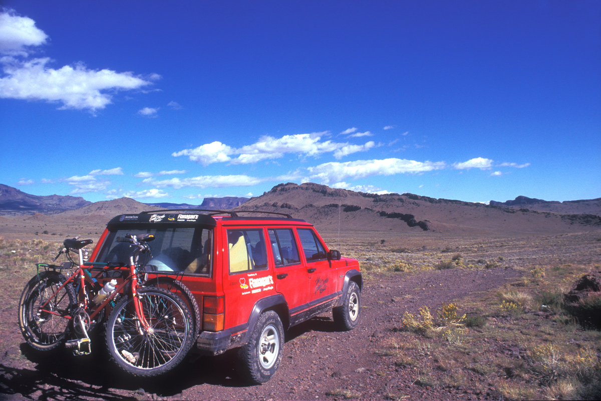
Serendipity raised its beautiful head again when Flanagan Motors in Missoula decided they liked a proposal we had submitted to them. Yes, they would like to provide Adventure Cycling with a brand-new four-wheel-drive Jeep Cherokee to use as a research vehicle.
The ball and the red Jeep were rolling, full-speed ahead.
That Sinking Feeling, Part 1
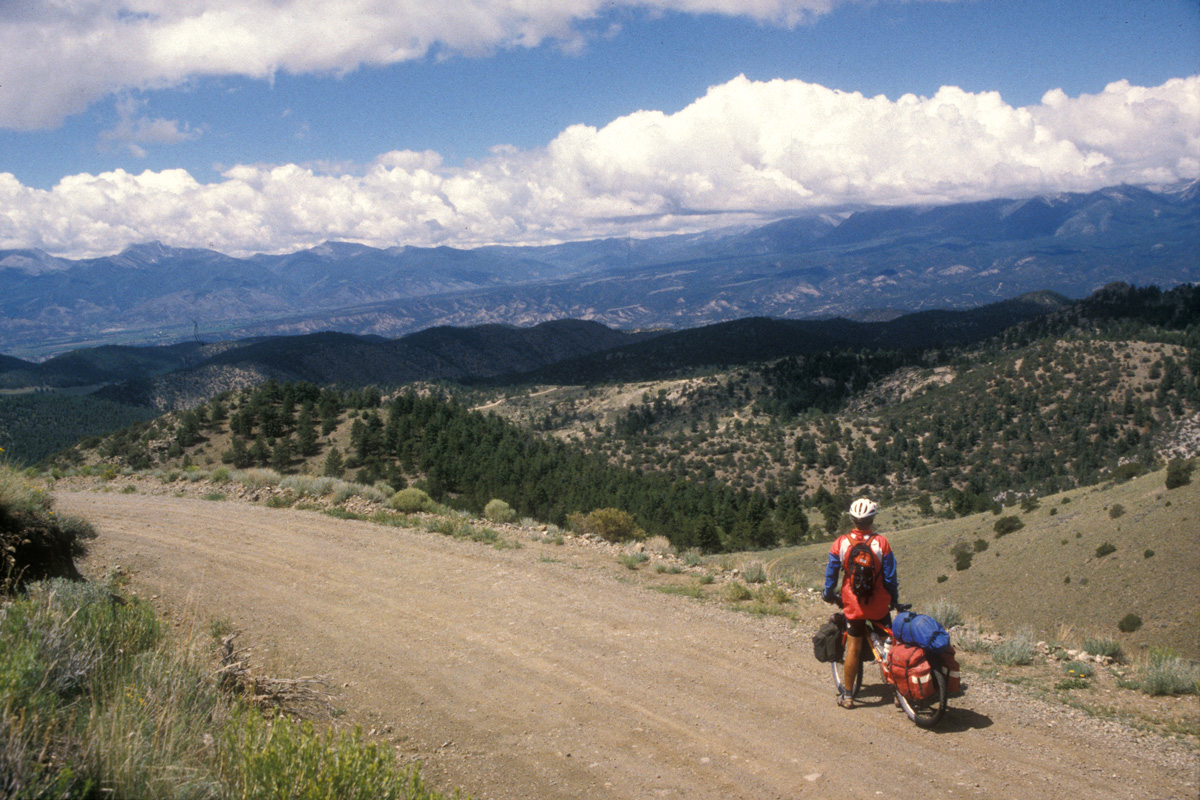
My first research trip through the newly determined route corridor west of the Continental Divide took place in mid-June 1995. The outing dished up an eye-opening array of the sorts of challenges I could expect to face on the long trail to Mexico.
Near the Grave Creek/Yakinikak Creek divide in the Whitefish Range, just 35 miles from the route’s beginning point north of Eureka, a pile of avalanche snow and timber debris three to five feet deep stopped me and my Kootenai National Forest companion dead in the Jeep’s tracks. The deposit covered only about twenty feet of roadway, but there was no way to get the Cherokee through, over, or around it. Adding insult to injury, I could walk from one end of the snowdrift to the other in about four seconds.
Aaaaargh!
I spent the rest of the day driving nearly 200 miles, mostly on bumpy back roads, to get the Jeep to the other side of that pile of snow.
The very next morning, after camping beside the snowmelt-swollen North Fork of the Flathead River at Big Creek Campground, I escaped in a very hard rain — and in the nick of time, as it turned out. I learned the following week that a total of five inches of rain fell during that weather event, the settlement of Polebridge became an island in a makeshift lake, and several campers at Big Creek were stranded for three days.
As the deluge continued, I plotted a route through the drenched Flathead Valley before climbing back into the mountains south of Ferndale. There the rain turned to snow; halted by a June blizzard. I bagged it, did a 360, and retreated, vowing to return the following week.
Laughs
North of Basin, Montana, while heading upstream along Cataract Creek, Nancy and I got trapped in a high-country traffic jam. There was scarcely enough room for two vehicles to pass on the timber-embraced road, and definitely not enough room for one vehicle, 400 head of cattle, and five whistling, whooping drovers on horseback. For fifteen minutes everything was all cow butts, cow stench, and calf heads, as the animals squeezed between us and the pine trees. Mooing their discontent or whatever, they rocked the Jeep and soiled it, smearing the windows with their messy rear ends and snotty, crap-covered snouts.
Hope
Multiple flat tires — on both the Jeep and my Fisher Paragon — moose and bear encounters, and getting lost outside Wise River on Fleecer Ridge (you Tour Divide racers remember Fleecer!) were some of the Montana challenges that followed.
Mere bumps in the trail. We were off and running!
Later that summer, still 1995, the Big Sky State’s 700-mile contribution to the Great Divide was in the bag. I wrote in my “Trail Boss” column in Adventure Cyclist: “It doesn’t get any better than this [Montana segment], so I’d be stretching the truth to say that the route will only improve as we continue into Idaho and Wyoming. But it’ll be just as good, so stay tuned.”
I didn’t really know this was true, of course, but I had a feeling …
Confidence
The magazine articles — in our own publication and in Outside and the other magazines mentioned earlier — stirred up a groundswell of interest in the Great Divide. This armed us with a solid resolve that what we were doing would actually be embraced by the cycling world.
Then — joy of joys! — REI bought into the idea of the Great Divide. (Angel Rodriguez, a board member of both Adventure Cycling and REI, was instrumental in gaining this support.) Ultimately, the outdoor retailer giant provided us with $40,000 for the Great Divide through their Great Outdoors grants program.
And, working again with Travel Montana, Adventure Cycling marketing director Kevin Condit and I got our shot at 15 minutes of fame when we “starred” in an episode of Men’s Journal on ESPN. We filmed the segment in three different Montana locations along the Great Divide in October 1995, and it would air the following spring.
At the same time, Adventure Cycling’s membership began buying in to the project, as individuals contributed $100 per mile through a dedicated adopt-a-mile program. We raised more than $60,000 between 1996 and 1998 via this campaign, permitting us to publish two map sections of the route in each of those three years.
The cycling and greater outdoor communities were getting psyched about Adventure Cycling’s new off-pavement bikepacking route, and the excitement rubbed off on us.
Absolution
As the route’s chief planner and researcher — my title at Adventure Cycling had changed from assistant director to national coordinator of the GDMBR — in 1995 I migrated south along with the trail. That July, Nancy and I moved from Missoula to our current home in Teton Valley, Idaho. Throughout the dry months of the following year and a half, I continued researching the route from southern Montana through Idaho and Wyoming and into Colorado. This leg included the challenging Great Divide Basin of south-central Wyoming, where zero services and almost an identical amount of water are found for more than 130 miles. Our knight in shining armor here came in the form of Ray Hanson, an Adventure Cycling member who also happened to be the recreation planner for the aptly named Great Divide Resource Area of the BLM, headquartered in Rawlins. Ray knew the country well.
By fall of 1996, with the route plotted well to the south of Steamboat Springs, the proposed Longest Mountain Bike Trail in the World was more than 50 percent mapped.
“This thing is spectacular — people are gonna go nuts over it!” That’s what I was thinking by this time.
That Sinking Feeling, Part II
As I scan the maps and reflect on my research adventures of a decade and a half ago, I’m flooded with memories. Like the occasion in June 1996 when I learned that Jeeps can’t swim, by swamping the Cherokee in rain-swollen Rock Creek outside Kremmling, Colorado.
After easily driving through a creek crossing that was not terribly wide or deep, I approached a second crossing just down the road. I thought it was the same creek (it wasn’t); it seemed a little wider, but not that bad (it was). Still, for reassurance I switched into four-wheel-drive, then gunned it.
Next thing I knew I was stopped dead in the middle of way too much running water. It lapped against the tailgate window. The current rocked the rig.
With the tailpipe submerged, the starter motor wouldn’t even turn over. So, adding stupidity to misfortune, I forced open the upstream (driver’s side) door, inviting what was probably hundreds of gallons of water to gush into the Jeep. I got out and quickly slammed the door shut, then struggled through the ice-cold, waist-deep water to the road. After gathering myself, I decided I would return to the vehicle, get my valuables and grab my bike off the back rack, then ride for help.
But first, after reentering the Jeep by crawling through an open window, I tried again to start it. This time the starter did turn, so I tried something I really didn’t think would work: I shifted into four-wheel-low first gear, released the clutch, and walked the rig out of the creek by turning the starter over with the ignition key — whAH, whAH, whAH — maybe 12 inches per step over a distance of at least 15 yards.
Dry land!
I got most, but not all, of the water out of the Cherokee’s interior by opening the doors. Later, as I crested and started down Gore Pass en route to Kremmling — where I would take everything out of the inside not nailed down and set it and the Jeep in the hot sun to dry — water came rushing from the back to the front, reaching halfway up my calves and submerging the foot pedals. I thought I was going to see trout swimming at my feet.
The next morning, after it was all drained and dried out, the Great Divide research vehicle seemed no worse for the wear. It would’ve made a helluva Jeep ad.
Hunger, Followed by Sickness
I love Mexican food; and, when I was younger, the hotter the better. But somewhere along the line my insides aged faster than my taste buds, and decided they didn’t appreciate the ultra-hot habanero chile-type stuff … but it was a lesson I had to learn over and over again (still do now and then, in fact). One of the strictest lessons came during a break in the research, off-route in Chama, New Mexico, from a teacher named Vera at Viva Vera’s Mexican Kitchen.
Suffice it to say that Ramon, who joined me periodically on research trips, did the driving the next day. He had to stop for me about every 15 minutes. But you don’t want to know any more about this — really.
Fear and Loathing
Out in the middle of Nowhere, New Mexico, I drove through an open road-block gate sporting an unlatched padlock hanging from the locking mechanism. 15 miles later I ran into another gate, this one shut and locked. Returning to gate number-one, I now found it closed and the padlock clicked shut.
I was locked in.
I had no cell phone in those days (and there’s probably still no reception out there, anyway). The solution arrived magically and weirdly in the form of a six-foot-fourteen enforcer-type possessing the key I needed so badly. He drove a citified sedan, wore city-shined loafers, had a Rocky Balboa build, and revealed a bulge in his sport jacket that I figured was a handgun. I know he did not believe that I had found the gate unlocked because it was not supposed to be unlocked. Someone had tampered with it, and he assumed it was me.
To this day I’m not sure if he was unable to smile, or just unwilling to.
And to this day I still believe I was on public lands. But maybe I misread the map. It’s been known to happen.
Appreciation for Those Who Go Slow
Three summers and autumns of research got me up close and personal with a constantly changing spectacle of amazing landscapes and great riding. It also put me in contact with a mix of terrific individuals; people like retired schoolteacher Rich O’Brien of Mankato, Minnesota, who pedaled the route over the course of two summers (1997 and ’98), becoming, we think, at age 65 just the third Great Divide through-rider to pull up to the Mexico border.
Of that approach he wrote, on his old Royal typewriter:
“Of all the miles, the most memorable had to be the last. I could see the border buildings up a gentle rise ahead of me. I stopped and then rode very slowly. Mixed emotions: I was glad it was over, but not so. To think back over all I’d gone through to get to that last mile. Hot, cold, mud, rain, ups, downs, bike breakdowns, flat tires, the ‘where’s the water?’ Bugs, camp food, the pie and hash browns in Pie Town, all the really great people, and the wind, the damnable wind. Then there was the solitude, just the sound of your tires crunching along with you. No fences, no electricity or telephone poles, no contrails above, no houses … just you and the crunching tires. Unique. Good for the spirit.”
And Matthew Cohn, who I mentioned earlier as one of the Adventure Cycling board members who had to be persuaded the idea of the Great Divide was more than half baked. On June 4, 2010, he wrote these words to me:
“This year we will finish the last segment of the ride (Pie Town to Antelope Wells). I think our group is setting a new record for the longest time to complete the trail … twelve years to be exact. The route has been amazing and the riding is unforgettable. Frankly, it has ruined me for road touring.”
Tequila!
At last, late summer 1997, Ramon and I ambled across the international border from Columbus, New Mexico, into Puerto Palomas de Villa, Chihuahua — where Pancho Villa himself once infamously crossed — to acquire a proper bottle of fermented juice of the agave plant and ¡Salud! the wrap of the Great Divide.
Kudos to Others, and the Exultation of Solitude
Those who helped. Too many to list them all, but several stand out. Forest Service people in Montana, particularly at the Northern Region headquarters in Missoula. Forest Service folks in Colorado. Joe in New Mexico. Rob and Robin in Montana. Ray in Wyoming. Nancy in Montana and Colorado. Ramon in Colorado and New Mexico. The entire staff at Adventure Cycling HQ.
Places. The climb from Del Norte to Indiana Pass and the apex of the Great Divide. New Mexico’s Polvadera Mesa, a 20-mile-long ramp to the sky composed of solidified volcanic ash. The crazy maze of dirt tracks etching the madly eroded badlands between Cuba and Grants. Camping out off-route beside Abiquiu Reservoir as the setting sun transformed the New Mexico desertscape into a Georgia O’Keeffe painting.
Relaxation. Lying down face up for ten minutes in the middle of the paved road that leads to Antelope Wells, just to see if it could be done. Neither car nor rattlesnake disturbed my repose.
Dreamtime
For several years after wrapping up the research, whenever I was having trouble sleeping at night I would put myself at the Canadian border and think my way south along the Great Divide. In particular, I would try to picture the turns where the route goes from one road or trail to another. The farthest I ever got before falling asleep was somewhere around Yellowstone.
As time marches on, the passes and turns, the mountainscapes and rushing streams, become foggier and fainter in my mind. Recently, I’ve run out of memory before returning asleep — i.e., I can’t remember what a lot of route looks like anymore.
Envy
Matthew Lee told me that last year, 2010, was the first time he was able to ride the entire Great Divide without using maps. I’m sure I wouldn’t be able to do that at this point.
Resolve
The final pair of anecdotes above are two reasons I’ll be seen out on the route this summer, 2011. I won’t be racing it, but I will be riding it — and getting reacquainted with the Great Divide.
Photos courtesy of Mac McCoy
This piece originally appeared in volume two of The Cordillera (2011), a book about the Tour Divide subtitled "Literature & Art from the World’s Toughest Bike Race."
Michael “Mac” McCoy has served Adventure Cycling in many capacities through the years but will probably go down in organizational lore as the father of the Great Divide Mountain Bike Route.
ADVENTURE CYCLIST ONLINE EXTRAS appear monthly on Adventure Cycling’s blog. If you’re an Adventure Cycling member, you can log into (or create) your My Adventure Cycling account to access the digital edition of Adventure Cyclist magazine and read the accompanying feature.
Not a member? Learn more and join today.
