Swell On Wheels
This article first appeared in the August/September 2013 issue of Adventure Cyclist magazine.
I was pedaling alone through a deserted corner of Utah, the first stars punching through the dome of the evening sky, when I saw the lion. Or what looked like a lion. It was too shadowy and quick to say for sure, but I feathered my brake levers, which were secured to my handlebars with zip ties and duct tape, and futilely squinted into the dusk. Riding on, faster now, rock walls launched into the sky at my side, their crenelated faces blushing in the day’s last light. I wanted to look up the names of the more dramatic peaks, but I had no map. No matter, it was all achingly beautiful and my smile led the way as I continued on, pedaling hard, further and further into nowhere.
To understand why I’m streaking down a remote dirt road through failing light into one of the more isolated deserts in America — out of water, without a map, lights, or overnight gear of any kind — you have to know the convoluted history of this star-crossed bike journey into Utah’s San Rafael Swell.
It began when an early-season snowstorm scuttled my plans for a weeklong tour in Idaho. I wasn’t ready to let go of the cycling season yet, especially after getting fired up for a tour, so I did what snowbound cyclists across the West do this time of year — I looked at a map of Utah. There are plenty of places you can ride well into December — Moab, the Canyonlands, Gooseberry Mesa — but I wanted to go somewhere new, somewhere that wasn’t overrun with cyclists yet.
The San Rafael Swell in central Utah had been on my radar for a few years. I knew it was in the middle of nowhere and I didn’t know anyone who’d ridden there. In fact, I didn’t know anyone who knew anyone who’d ridden there, which was enticing. Like many bicycle tourists, I like to explore, and the more I can trick myself into feeling like I’m exploring something no one has ever ridden, the more fun it is. A bit of Swell research revealed it to be a landscape of deep canyons where Butch Cassidy once hid, and a land riddled with remote routes, pictographs, and dinosaur tracks. In short, it sounded perfect. So I called my buddy Rod Kramer, former Adventure Cycling Tours Director, who now works for a trails nonprofit in Ogden, Utah. He was up for a road trip, but didn’t think his dog, Jack, could handle my proposed four-day bikepacking traverse of the region. So we compromised — we’d “camp” in his Volkswagen Westfalia and do exploratory day rides. It would give me a chance to scout the region for a possible future traverse and I’d get to hang out with my pal Rod and his super-deluxe camper van. What could go wrong?
We found what around midnight of our first night as we rolled into our campsite at The Little Grand Canyon. The van had just started acting strange a minute before, triggering warning lights on the dashboard. But we reached our camp spot and turned off the van without trouble. Then, as we stood outside admiring the view at a spectacular, moonlit campsite on the edge of the 1,300-foot deep canyon, the van started running. The engine was trying to turn over and over as the van lurched forward — without us in it. Rod quickly leapt into the van to pop it out of gear and figure out how the hell his van was starting without a key or driver. Meanwhile, I did the only sensible thing — I jumped in front of the van, spreading my legs wide on the loose desert soil, and pushed against its front grill with all of my strength to keep it from rolling into the abyss. In retrospect this may not have actually been sensible, but I do love Rod’s van, plus my brand new Salsa 29er was on the back.
After a few frantic minutes worthy of a Three Stooges film, we finally disconnected the van’s battery, which seemed to exorcise its demons.
“That was like something out of a Stephen King novel,” I said as we slumped against the van’s side.
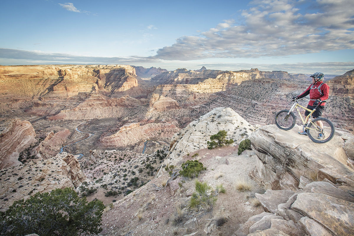
As you might imagine, it wasn’t my most restful night of sleep, ensconced in the canvas of the van’s pop-top upper bunk, blowing and shaking in the night wind on the edge of the canyon. But the morning dawned like a desert rose, with crystalline sunshine flooding the canyon below us. As we stumbled out into the brisk morning air, we saw its true magnitude for the first time — a great chasm in the Earth dropped away into a labyrinth of sandstone, with multi-hued walls wending back to distant arrowhead peaks. Some 1,300 feet below us, the San Rafael River snaked through the canyon floor like a distant blue serpent. It may not have been the Grand Canyon, but it wasn’t far off.
After a moment of silence Rod said, “So, I’m glad the van stayed up here.”
“I’m glad we stayed up here,” I added.
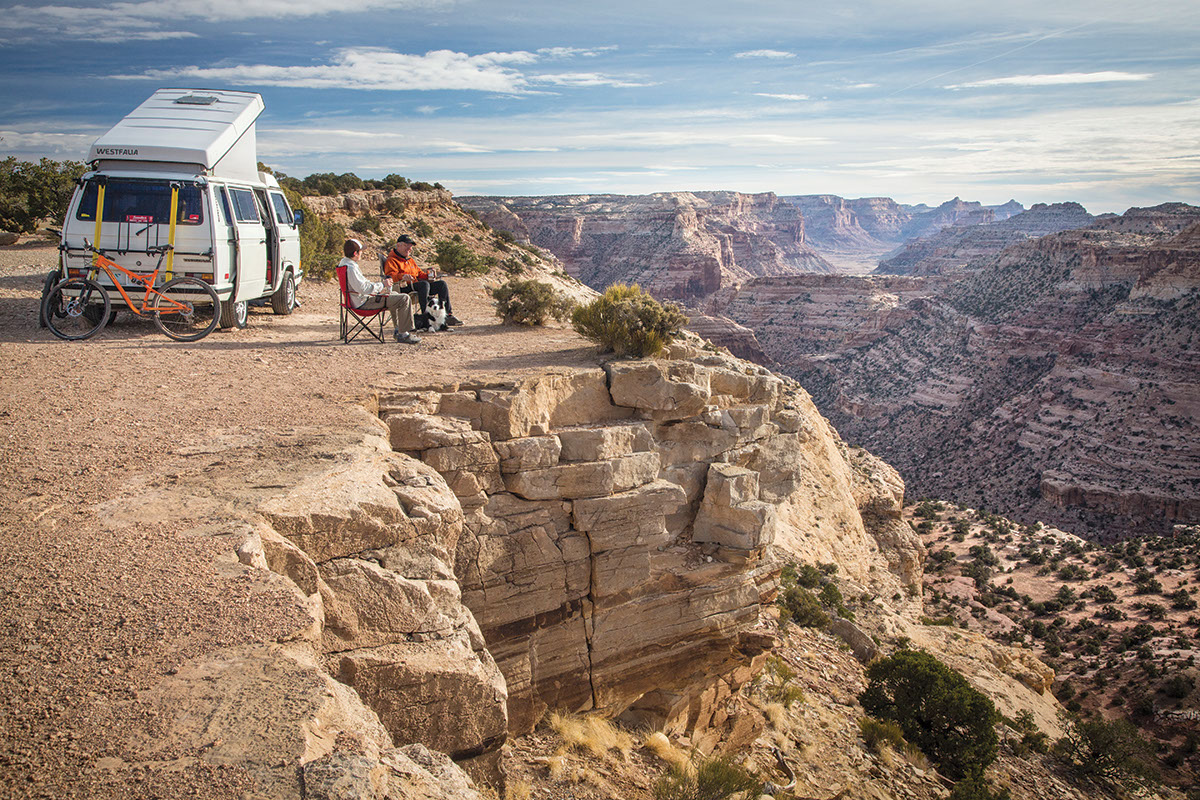
We were perched at a point named The Wedge Overlook, where a subtle, unsigned trail led away from the campground in the direction of the canyon’s edge. We’d read about this trail — the Good Water Rim Trail — and it was a big reason we chose to camp there. The few reports on the Internet said it was new and still a bit rough, but that it was already one of the finest mountain bike rides in Utah.
As we finished breakfast, a white pickup truck pulled up and a heavyset man with gray hair stepped out. This was Lamar Guymon, former county sheriff here for 33 years. He’d heard we were coming to do a magazine story on his stomping grounds and was eager to meet us. After a lifetime of rescues, manhunts, and his own frequent explorations, he knew the canyons and plateaus of the Swell as well as anyone, so he’d become a guide in his retirement. With his large truck and ample girth, he looked for all the world like an ATV enthusiast.
As we sat beneath the morning sun in camp chairs overlooking the canyon, I asked him about the Good Water Rim Trail.
“It runs for 20 miles along the edge of the canyon,” he said in a soft-spoken voice. “I’ve been building it for a while now.”
“You built the trail?” I asked incredulously, citing number 5,380 of the Don’t Judge a Book by its Cover lesson manual.
That’s when I noticed the words on his truck, “San Rafael Country Adventures — Driving/Biking.”
Guymon said he discovered mountain biking in the late 1980s, and about 15 years ago he started exploring the cattle trails along the rim of the canyon. Over time he started making improvements while being careful to steer clear of local Bureau of Land Management (BLM) officials, who oversee the Swell and were clamping down on illicit trail creation by ATVs, which they failed to differentiate from the much lower-impact, human-powered cycling. The lid came off, however, when Guymon and the local mountain bike club, MECCA (biketheswell.org), soon held a festival in the area.
“Then the trail shows up on Facebook and the web,” Guymon said.
Gone are the days when a trail like this might go undiscovered for years. Now word spreads like digital lightning.
Then, one day, a new recreation manager for the BLM said to Guymon, “We know all about your trail.”
“What trail is that?” Guymon asked.
“The one on Facebook and the Utah mountain bike site — the editor’s choice.”
“I don’t know about that one. I’ll have to check it out,” Guymon said. “Are you going to close it?”
“No, we’re going to sign it,” the BLM guy said. “We’re going to make it legal.”
With that, the Good Water Rim Trail was legit. As Guymon pulled out a map of the area and showed us ride after ride, I realized this former sheriff turned renegade trail-builder was going to turn the San Rafael Swell into Utah’s next great mountain bike destination.
As Rod and I set out to ride the trail, Guymon pointed to a spot that looked about a mile away and said, “You’re going to end up over there — it’s about 10 miles of trail to get there.” I didn’t believe him. It couldn’t possibly be 10 miles, I thought. I could see it — right there! What I didn’t realize was that there was a concealed canyon between us and that spot, its many branches filigreeing across the landscape. The Good Water Rim Trail winds intestinally around them all, slicing through a pygmy forest of juniper and pinyon trees, etching along the edge of 500-foot cliff walls, and unspooling in a deliciously sinuous, rock-riddled singletrack. (When I later asked about the unrelenting twisting nature of the trail, Guymon, no fan of motorized use in the backcountry, admitted, “I wanted to make it so motorcyclists wouldn’t want to ride it.”)
As we rode on — dipping through rocky washes that fed the canyon, dodging snarling cacti, stabbing our handlebars over ledges and around hairpin turns — we were increasingly euphoric.
“Can you believe this?” Rod blurted. “This is my new favorite place. How come I’ve never heard of this? How come there aren’t a hundred mountain bikers here? This is like just discovering Moab!”
Back at the campground, I stopped to chat with a boisterous BLM ranger. All of the talk in the area had been about a leaked White House document suggesting a possible national monument designation for the Swell, something the ranger said he didn’t necessarily oppose, as long as they didn’t lock the place down with rules and regulations.
“Right now, it’s like a little bastion of America in here. If you want to camp here, you can camp here,” he boomed with a broad sweep of his hand.
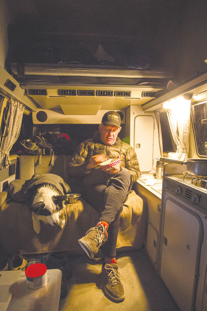
Fortunately the area encompassed by his gesture included where Rod’s possessed van was parked, because we were terrified to plug the battery back in. Rather than camp in a new corner of the Swell each night, our new plan was to leave the van right where it was and treat it like a not-very-mobile home. Not only did this guarantee us amazing breakfast views each day, but we had no other choice. Rod’s van was dead.
In the meantime, the van-camping was good. We had a perch on the lip of the canyon where we watched peregrine falcons and desert bighorn sheep. I had top-grade earplugs to combat Rod’s snoring — which his ex-wife accurately compared to “a cement mixer filled with broken chainsaws.” Plus, we had cold beer in the van’s fridge, solar panels on its roof to power our music players each evening, and world-class sunset watching, stargazing, and wildlife viewing every time we stepped outside.
As I cupped a warm mug of tea on our second morning and looked out over the maze-like canyon, it was easy to see why Butch Cassidy and a long line of outlaws had come here to hide. Guymon pulled up around 9:00 am, eager to show us some rides on the eastern side of the Swell. We climbed into his truck and set out across dusty roads through canyon and mesa, and past Window Blind Peak. At 7,030 feet, it’s the tallest freestanding monolith in America.
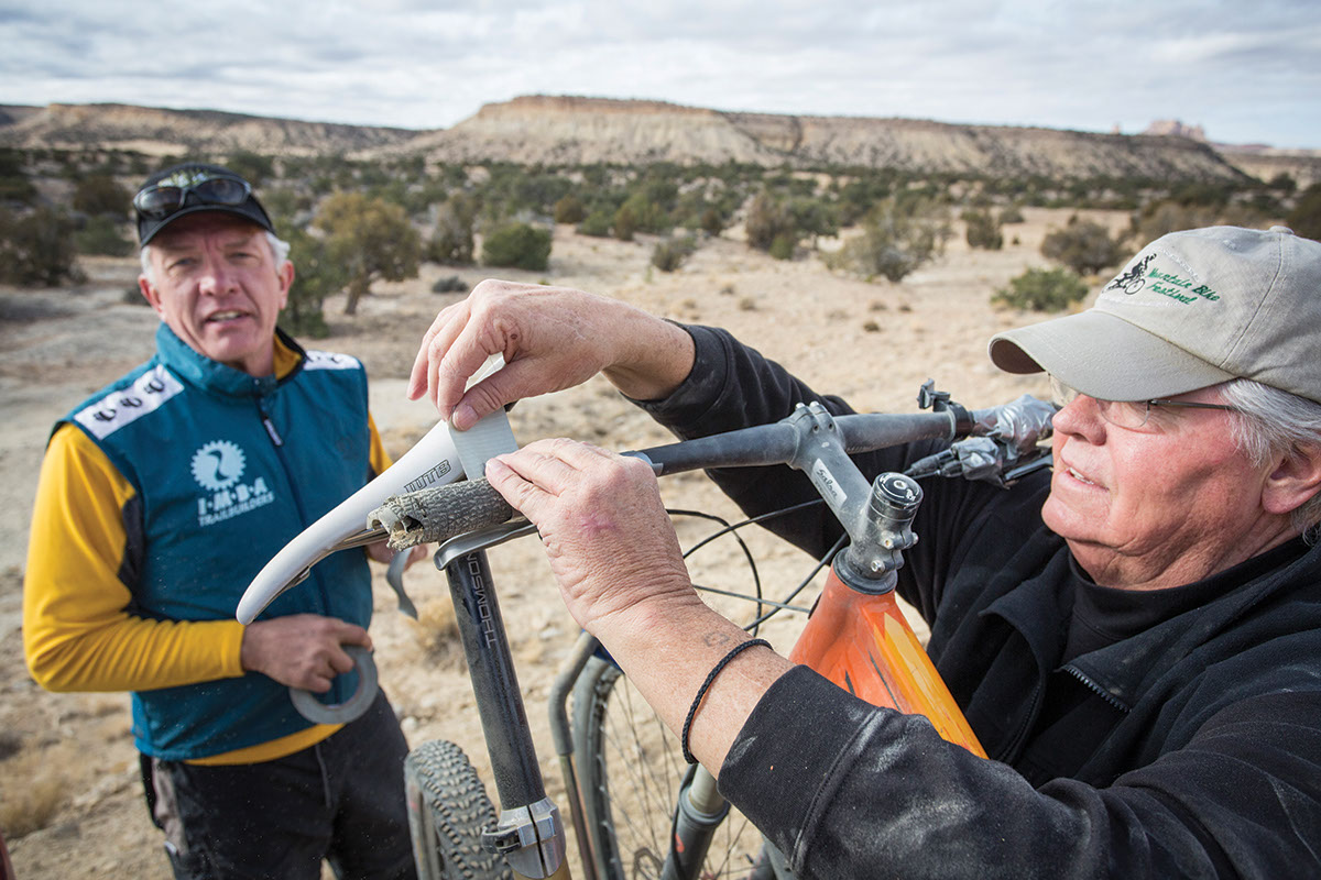
Our marveling at the scenery came to a sudden halt about half an hour later, however, when we realized that my bike was not, in fact, riding peacefully on the tailgate rack but was instead being dragged behind the truck across rock and road. An inspection revealed the damage — the left side of the handlebar had been ground down by at least an inch, the brake and shift levers had broken off the handlebar, and my Carousel Design Works top-tube bags were history.
I was crestfallen. Clearly my bike was toast. But Guymon wasn’t so easily deterred. He had tape and zip ties in his truck. Lots and lots of tape and zip ties.
Within 10 minutes, I had a functioning bicycle, complete with plenty of “dirtbag chrome” holding my cockpit together. More importantly, we could ride.
Guymon, who had a leg injury and couldn’t join us, dropped us at an unsigned junction of dirt roads on a sun-baked plain. We pointed our wheels down a road known as Jackass Benches and rolled into a classic high-desert ride along an undulating ribbon of dirt sprinkled with rock gardens. Mesas and monoliths rose in the distance. Flocks of pinyon jays called from the scrub forest. Giant anthills and the bleached skeleton of a cow littered the roadside. There were no other humans — nor any signs of other humans — and spur roads leading to who-knows-where begged for further exploration. It would have been excellent country for bike touring — if it weren’t for the total lack of water.
The reason for the road’s name, Jackass Benches, started to make sense as Rod fixed a flat tire and I heard a mysterious snort from above. Startled, I looked up to the sight of two wild burros grazing on a hillside. There was a pioneer trail here in the first half of the 19th century linking New Mexico and California. Not everyone made it through the Swell, but the ancestors of their burros live on.
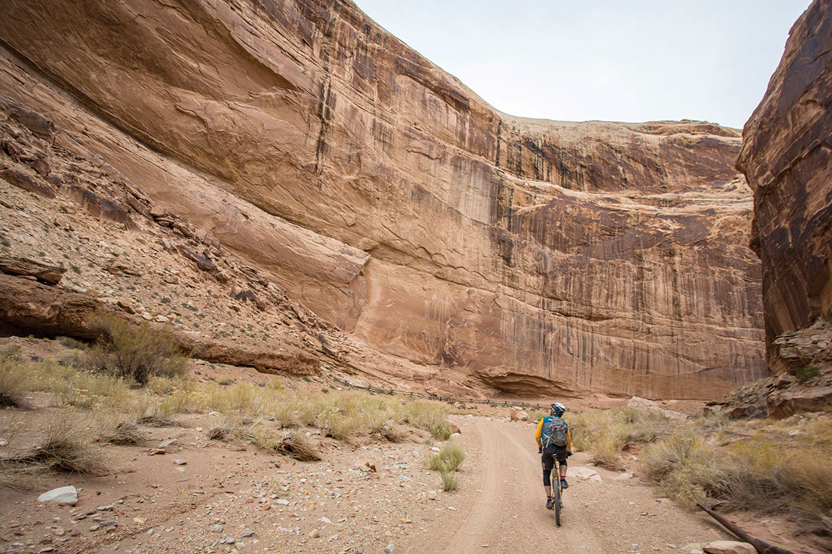
It wasn’t just pioneers that left their mark on the Swell, however, as we soon discovered while dropping into the varicolored canyons of Dragon Wash. Our rocky, plunging jeep road carved ever deeper through layer after layer of ancient sandstone as we dropped toward the eastern edge of the Swell — though it seemed just as likely we were heading to the core of the Earth. We lofted our bikes off rock shelves, leaned them through snaking turns, and stopped at virtually every new bend to take in the views. That was when our expert eyes picked out something unusual on the side of a particularly dramatic wall of rock. Okay, so it helped that the area was fenced off and signed.
Closer inspection revealed a pictograph in the form of a winged dragon. Nearby were other ancient artworks — many of strange, alien-looking creatures — left by the little-understood Barrier Canyon Culture at least 2,000 years ago.
As we rode on, the sandstone walls vaulted higher as they closed in around us, our path only a serpentine crack through bulging walls of red stone.
“I’ve never been farther from my day-to-day life than right now,” Rod dcalled back to me.
As we were learning, the Swell has a way of making you feel that way.
Our plan the next morning was to exorcise Rod’s van by rewiring it with instructions his mechanic friend had sent us, then ride into the deepest, most remote corner of the Swell. But after a historically impressive bout of cussing, wire-connecting, and van-exorcism instructions via phone (surprisingly, we had cell service), it became clear that Rod was going to have to spend the rest of the afternoon rewiring his car in the middle of nowhere. Suddenly his day-to-day life wasn’t looking so bad.
There was nothing I could do to help and I kept thinking about the ride we’d planned. Through Buckhorn Wash, on the far side of the Little Grand Canyon, there was a dead-end dirt road that paralleled the San Rafael River Canyon, gradually dropping down to the river itself, crossing into the Mexican Mountain Wilderness Study Area, and petering out at an old trail that led to Mexican Mountain and, in its furthest reaches, Delicate Arch. It all sounded so spectacularly remote and intriguing I couldn’t leave without trying to get there. So I did.
There was something intense and almost apocalyptic about leaving Rod with the possessed van. There wasn’t a soul around; a cold, 35-degree wind was pushing dark clouds across the sky; Jack the dog was glued to the van’s bench-seat, so tired from two days of running he could barely walk; and Rod was trying to connect battery wires on the rim of a canyon. I’d also been hoping to get more cycling images, but without a model that would be impossible. Melancholy settled over me as I pedaled alone into the barren rangeland behind the canyon.
After a couple miles, I realized all the critical things Rod had been carrying in his pack — like a map and the first-aid kit — were back with Rod and the demon van. Then I remembered I’d forgotten to grab my backup light after the first had snapped off the handlebar in the car-rack accident. A smarter person might have turned back.
“What am I doing?” I wondered to myself as I kept pedaling. “Why do I do this? Why do I travel all over to ride bikes in these remote places? Is this crazy?”
Soon the road left the plain and started its gradual descent through the Navajo sandstone of upper Buckhorn Wash. Sloping stone walls rose along the road as I descended, the angled lines of their strata converging like giant sandstone muscles. As the clouds parted, the sun gradually emerged and my mood started to rise. I inspected a fossilized dinosaur track and the entrance tunnel of a secret Department of Defense project from the 1940s. Then I looked at a sprawling line-up of pictographs on a cliff face — ancient drawings of sheep, deer, and humanoids. Everywhere were signs of the Swell’s mysterious past.
Suddenly, I heard rocks clattering above me and saw a pair of mule deer scampering across an impossible ledge. A flock of maybe 60 swallows landed in a tree next to me. Breathing in the smell of damp sand and the previous night’s rain, I stopped at the wash of a small rivulet and spotted a wild burrow and some animal tracks in the sand. There was more than history here, there was life, hardscrabble, beautiful life grabbing hold wherever it could.
The sandstone cliffs rose higher and higher as I rode — 300, 500, 800 feet. Alternating between sun and shade, I plunged through the canyon on a fast, smooth dirt road. Old cottonwood trees with copper leaves still clinging to their branches cut gnarled silhouettes from the red rock. Ravens circled high along the cliff edges against the blue of the sky, soaring and swooping and twisting inches from the sunny canyon walls. They appeared to be just having fun — like me.
Two cars in an hour; it was like my own private bike path through Mars. Not that I was very good at staying on it. I clambered up to caves and followed trails leading to amphitheaters and side canyons. I was mesmerized by the vaulting rock — buttes and spires and cliffs stacked atop cliffs. With all of its varicolored epochal layers, it felt like I was looking at time itself.
Where the road finally reached the river and the canyon opened to the larger world, now sunny and golden in crisp, late afternoon light, I saw Guymon in his white truck. He knew where I’d planned to ride and had come to check on me.
“You’re not going to make it to Mexican Mountain at this rate,” he said with a smile. I know, I said, and then tried to explain all of the amazing things I’d seen and explored in Buckhorn Wash. But I didn’t have to. Guymon knew. That’s why he loves it here.
From where we talked, Mexican Mountain Road led south into the nowhere. Daylight was running short. When Guymon said he’d drive down and find me if I wasn’t back before dark, I set off with a mission: get as far down the road as I could before sunset to see what new mysteries the lonely country there held.
The road glided under my tires like a desert river as I sped along through honeyed light. The thrill of exploration and the otherworldly beauty of the landscape seemed to propel my bike like magic. Intrigued by the way the low sun was throwing my shadow, I took photographs of it as I rode. Who needs models! To my right was wide open space where the San Rafael River canyon dropped away to unseen depths. Beyond it, in the far distance, were Jackass Benches and Dragon Wash. To my left, the sunlight slowly climbed sandstone walls, their red and tan and gray strata like colored bands of eternity captured in stone.
On I rode, my spirit soaring, as sunset-painted cirrus wisps and a luminescent contrail streamed across the sky. Pinyons, junipers, and sage rising from the red soil glowed in the twilight. A lone star appeared in the east above a red, toothy cliff band. Probably Mars. But surely I was on Mars now, so maybe it was Earth.
This is when I may have seen the lion. But I didn’t stop, couldn’t stop now. There was more to see. More stars penetrated the night as the last threads of orange light clung to the western horizon. A massive, crenelated peak rose up before me as the road twisted down into the darkness below. My eyes were wide but my smile was wider. I was as alive as I’ve ever felt.
This is why we ride. This is why we come to places like this with bicycles. We come for the wonder, the beauty, the adventure. We come to pedal out of our own lives and into new worlds. We come to celebrate being alive. Right then, spilling over with vigor, I didn’t care about Rod’s possessed van, or my battered bike, or anything except the thrill of streaking into the glorious, desert night of the San Rafael Swell.
Nuts & Bolts
San Raphael Swell
The San Rafael Swell
Known as the Swell, it’s a 75-mile-long sandstone bulge in the high desert and is three-hour drive south of Salt Lake City and an hour northwest of Moab. Over the millennia, the waters of the San Rafael River and its tributaries have carved deep canyons here, providing refuge for a series of ancient civilizations that adorned the soaring rock walls with pictographs and petroglyphs. ATV traffic has dominated the Swell in recent years but stricter rules from the Bureau of Land Management, which oversees the majority of the area, have begun limiting their access. Now, hikers, climbers, and cyclists are the fastest-growing user groups, though motorized crowds can still reach high densities during busier periods and holiday weekends.
Logistics
Price, population 8,600, situated just off the northern tip of the Swell, has the region’s only bike shops. Gilly’s Motel in Ferron (435.384.3333) is the nearest lodging to the The Wedge and the Swell’s western entrance. The Wedge, overlooking the Little Grand Canyon, hosts some of the area’s finest car-camping, though informal sites exist throughout the region. Interstate 70 bisects the Swell, and though we stayed in the northern half, the southern half also contains excellent Jeep-road riding options.
Bike Shops In Price
Altitude Cycle: 435.637.2453 or altitudecycle.com
Touring Potential
There are plenty of quality routes and potential traverses in the Swell, but as in any desert the biggest challenge is water. The Muddy River, located in the southern Swell, lives up to its name, and the San Rafael River isn’t much better. You could prefilter through a bandana, then treat or filter afterward, but it might be wiser to create water caches if attempting self-supported rides. Car camping and day rides will be a better option for most.
When To Go
Summer is scalding, spring and fall have more ATV traffic, and mid-winter can mean snow. The Swell’s secret is late fall/early winter. November and first half of December often mean sunny skies and no crowds.
Resources
• Lamar Guymon, (435.749.5300), lguymon@sdarc.us, based out of nearby Huntington, is the best local resource for cycling in the Swell. He can recommend rides and offers shuttling and guiding services.
• Hermosa Tours offers unique “self-guided” bike tours of the region, including nearby Capital Reef National Park. They provide a route, move your camp gear each day, but leave the riding to you.
• Mountain Biking Utah’s Canyon and Plateau Country, by Gregg Bromka, is a the best available resource for biking the Swell.
• Hiking and Exploring Utah’s San Rafael Swell, by Michael Kelsey, is the best overall guide to the region.
