Riding the National Parks, Part 4
Welcome to the fourth installment of my national park series. To date, I’ve covered 20 national parks. I’ve immensely enjoyed researching and getting to ride my bike in these amazing national parks. With each installment, I’ve dug a little deeper to find quality riding experiences.
I believe I have exhausted most of the worthwhile cycling opportunities in the Lower 48, but I’m sure there are still a few more possibilities out there such as Canyonlands and Arches, to name two. If I can wrangle an assignment with an all-expenses paid trip to Virgin Islands National Park, I might be persuaded to find a few trails there as well!
Maybe I was saving these parks for last so I could get in shape to tackle their epic climbs. All of the parks listed in this edition have several items in common:: they’re fairly remote, are at high elevation, and contain some of the most epic climbs in national park road cycling. Get those legs in shape and explore a few (more) of the country’s parks on two wheels.
Olympic National Park
The Olympic Peninsula in Washington has long been a popular destination for touring cyclists for its snow-capped mountain peaks, lush rain forests, wild beaches, and relatively low traffic along U.S. Highway 101.
For riding in Olympic National Park proper, you can nibble at the park’s perimeter with a series of out-and-back day rides or make it part of an extended tour that covers most of the north peninsula.
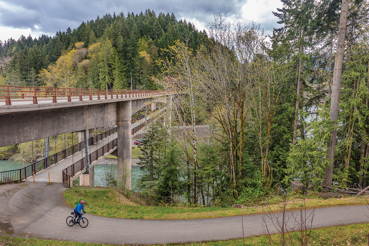
One great way to tie in a visit to the national park is by using the terrific Olympic Discovery Trail, which uses a combination of bike paths and roadways from Port Townsend on the northeast corner of the peninsula all the way to the Pacific Ocean at the small tribal community of La Push — over 130 miles in all. At the time of publication, there are over 80 miles of dedicated trail with more coming each year. Particularly enticing is the section on the north side of scenic Crescent Lake, which will travel through two tunnels (the McFee tunnel opened July 2017) and avoids the busy, narrow section of Highway 101 on the south side of the lake.
Hurricane Ridge
Start in the small city of Port Angeles to warm up the legs before beginning this epic climb. Over a distance of 18 miles, Hurricane Ridge rises from 34 feet above sea level in town to an elevation of 5,242 feet and provides spectacular views of the Olympic Mountains with stunning fields of wildflowers in summer. If there is a list of epic climbs in national parks, Hurricane Ridge Road would be near the top. One of the best times to test your climbing mettle is the first weekend in August when you can ride a metric century among the dramatic purple lavender fields in the nearby town of Sequim at the Tour de Lavender event.
The next morning you can experience “Ride the Hurricane” when Hurricane Ridge Road is closed to automobiles from 7:00 am to noon.
There are also a variety of great road rides near Port Angeles. Contact Tom Michowski at the Bike Garage bicycle shop for a detailed map of cycling routes in the area.
Sol Duc Valley
You can ride the Olympic Discovery Trail and come out along Highway 101 at a trailhead near the entrance road into the Sol Duc Valley. It’s a little over 12 miles of beautiful, mostly flat road through large trees alongside the Sol Duc River. The payoff at the end of the road is the 0.8-mile hike to Sol Duc Falls, or you can take a dip at the Sol Duc Hot Springs Resort.
If you happen to ride in late October into early November, pull over at the Salmon Cascades Overlook where spawning coho salmon are often seen leaping and surging upstream. There are also cabins and a campground located at the hot springs area.
Hoh Rain Forest
Base yourself in the small town of Forks, home of Twilight fame, and ride along the shoulders of Highway 101 for 13 miles to Upper Hoh Road. It’s another 18 miles along the Hoh River to the Hoh Ranger Station at the end of the pavement.
On clear days there are stunning views along the river into the backcountry where snow-capped peaks dominate the horizon. Most days will be overcast and rainy, and you can appreciate riding under the canopy of moss-draped trees. Take the time to park at the ranger station and do the short hike to visit the Hall of Mosses as it is an otherworldly experience of lushness.
La Push
You can also head the opposite direction from Forks and ride 16 pleasant miles along Highway 110 to visit the wild shores of the Pacific Ocean at the tiny Quileute Tribe town of La Push, which can be quite nice at sunset.
For a longer tour of the peninsula and the national park, continue south along Highway 101. You pedal literally right next to the Pacific Ocean at Ruby Beach and Kalaloch Lodge. You can can ride a loop around Quinault Lake. The short Maple Glade Trail is one of the most impressive rainforest environments that I have ever witnessed. It’s a good chance to see elk and very impressive waterfalls during the 31-mile loop. Be prepared for wet conditions as the valley averages around an astounding 12 feet of rainfall per year.
Grand Canyon National Park
The Grand Canyon is an icon of the American West with its dramatic views that reach all the way down to the Colorado River.
As I highlighted in a recent Adventure Cyclist article (“Second Chances at the North Rim,” Oct./Nov. 2017), the best place for cycling here is to travel to the park’s North Rim for mountain biking on the famed Rainbow Rim Trail. The 18-mile Rainbow Rim should be on the wish list of any cyclist who craves sinewy singletrack with amazing scenery. Rainbow Rim connects the five observation points that overhang the canyon: Parissawampitts, Fence, Locust, North Timp, and Timp. Note that the Rainbow Rim Trail skirts along the border of Grand Canyon National Park but is not in the park proper — it’s actually on Kaibab National Forest land.
If you go on your own, please know that the Rainbow Rim is in a remote setting. It’s a good hour-long drive on rough dirt roads to reach any of the observation points. There are no supplies along the route, so be sure to bring plenty of food, water, and first aid supplies. Also, there’s no phone service.
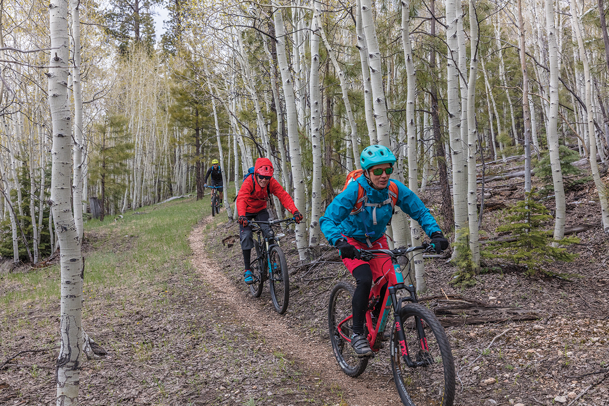
For more great mountain biking, you can also access the Arizona Trail at the North Rim continuing north into the Kaibab National Forest. There are some really nice sections through aspen groves and high meadows.
This is high-elevation riding — between 7,700 and 9,200 feet — so take it easy for a day or two to get used to the thin air, especially if you reside at lower elevations. Bring an ample supply of warm clothing as wintry conditions can happen any time of the year at elevation.
Road riding can be perilous on Grand Canyon National Park’s South Rim roads, where automobile drivers are prone to rubbernecking at the views. This problem is compounded by the narrow roadways combined with heavy traffic and distracted pedestrians crowding the pavement. There is hope for cyclists in the near future, however, as the park’s General Management Plan calls for banning private vehicles on the South Rim roads and replacing them with light rail and alternative-fuel buses, as well as a 33-mile greenway.
Presently, there is one notable exception to this general mayhem — you can ride along the Hermit Road, which is closed to private vehicles from mid-March through mid-October. The road travels for eight miles west of Grand Canyon Village to Hermit’s Rest and provides for peaceful, enjoyable road riding broken up only by the handful of buses (to which you must yield) that pass periodically.
On the North Rim, the park’s entrance road is wide enough for cyclists, but the traffic can be heavy during the peak of the summer season. You can ride 43 miles of Scenic Byway 67 from Jacob Lake to the North Rim Lodge passing by large, open meadows and several forest fire burns. Cape Royal Road is lightly trafficked, has nice pavement, and leads to amazing canyon views, but it’s narrow and does not have good sight lines for cyclists. If attempting this ride, go early and use caution.
Adventure Cycling Association puts on several van-supported mountain bike tours of the North Rim of the Grand Canyon that cover many of the areas that I’ve described.
North Cascades National Park
Opened to the public in 1972, North Cascades Highway, a.k.a. Washington State Route 20, was the last major road to be constructed across the Cascade Range in Washington. This scenic and adventurous road offers a chance for cyclists to traverse one of the most remote and diverse mountain ranges remaining in the Lower 48 states, and with lofty elevation gains, it can challenge even the fittest riders.
I first experienced this national park during the opening days of my eastward journey along the Northern Tier Route. My sister Lisa and I were not fully prepared for the epic climb up the remote highway — it’s 57 miles with over 7,000 feet of elevation gain from Marblemount to Washington Pass. I should have known we were in trouble when a sign along the road read, “Last beer for 89 miles.” We were fortunate that friendly folks along the highway gave us food and water.
In fact, when nightfall and cold temperatures settled in and my sister was still lagging behind, the only other person in the campground gave me a lift to find her. Our good Samaritan even took us to the next hotel where a welcome bowl of hot soup revived our bodies and spirits. My faith in human kindness was rekindled along the North Cascades Highway.
Two highway tunnels lie between the tiny towns of Newhalem and Diablo. The longest tunnel, closest to Newhalem, is fitted with a “bikes in tunnel” flashing light that can be turned on at either end. Before entering the tunnel, it’s advisable to turn on your headlight and taillight to become as visible as possible to other traffic. The highway closely follows the Skagit River from Marblemount to Newhalem and gains little elevation over 14 miles before the road begins to climb in earnest. The road climbs steadily to Rainy Pass at an elevation of 4,660 feet, and the forest transitions from Douglas fir to mountain hemlock and silver fir trees.
After reaching the scenic Rainy Pass, the highway loses about 300 feet of elevation before it begins the final ascent to Washington Pass where alpine larch, a deciduous conifer tree endemic to the Pacific Northwest, dots the timberline with splashes of bright green needles in spring and golden yellow needles in fall.
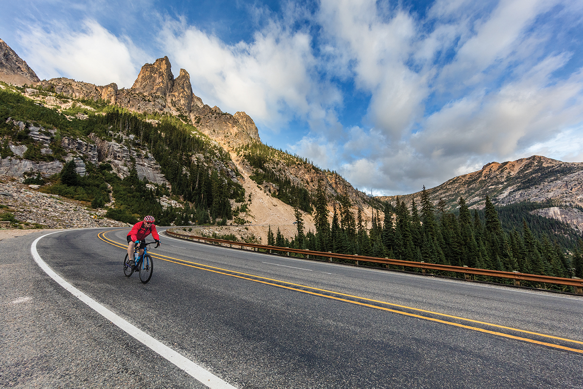
Finally, at an elevation of 5,477 feet you reach Washington Pass, the highest point on the highway. A short spur road at the pass leads to an overlook with fantastic views of the Early Winters Creek Valley and Liberty Bell Mountain.
You can continue east on the Northern Tier Route descending to the town of Winthrop where you can find supplies and all of the trappings of modern society once again.
Great Basin National Park
Great Basin National Park, located near the Utah state line in Nevada, doesn’t grab the national park marquee like Grand Canyon, Yosemite, or Zion. This mystifying area drains internally, with no streams, creeks, or rivers reaching either the Pacific Ocean or the Gulf of Mexico. How remote is the park? Well, U.S. Route 50, which runs just north of the park, is referred to as the Loneliest Road in America.
This unique park is home to over 40 caves. In Lehman Caves, the only section open to visitors, you can take a tour of the limestone cavern that features mysterious formations known as speleothems.
The landmark of the park, Wheeler Peak, soars to 13,063 feet with alpine lakes, an actual glacier, and the oldest living things on the planet — 5,000-year-old bristlecone pine trees that grow on rocky glacial moraines below the lofty summit. The park is a great place to experience the solitude of the desert, the smell of sagebrush after a thunderstorm, and the darkest of night skies from one of the park’s campgrounds. There were a wealth of wildflowers along with numerous birds and wildlife when I visited in May last year.
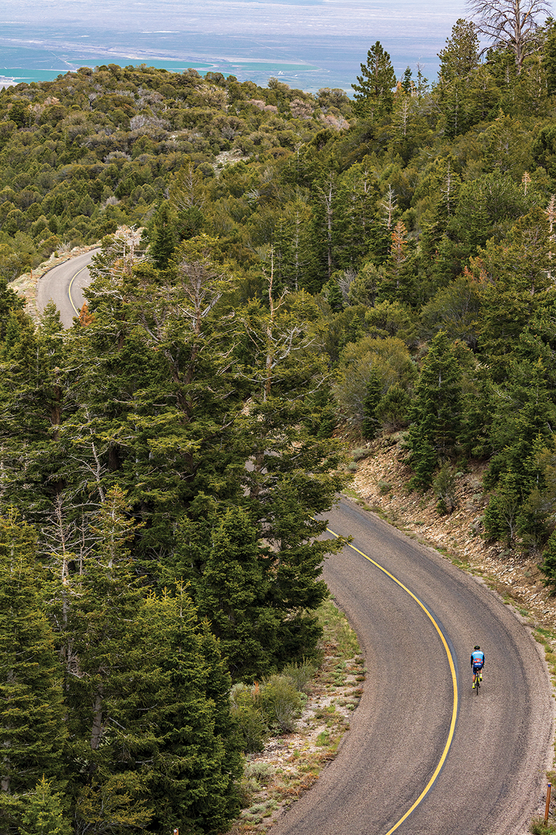
It’s a 16-mile grind of nearly 5,000 feet from the tiny town of Baker to the end of the road at the base of Wheeler Peak. Be prepared for a tough climb as the scenic road averages an 8 percent grade. In between huffing and puffing, there are amazing views into the desolate valley below as you pass through several distinct ecosystems ranging from high desert to ponderosa pine forests to an alpine setting. Make sure to bring a set of warm clothes and gloves for the long descent back down — it can be easily 20 degrees colder than the valley floor back in Baker.
As you might surmise, Nevada’s largest national park sees a low number of annual visitors (160,000), making for a chance to cycle up the road toward Wheeler Peak enticing. Baker, population 68, boasts a delightful restaurant and is just several miles west of Highway 21 at the Utah state line.
If mountain biking is more your thing, then travel about an hour (by car) west on Highway 50 to the town of Ely, Nevada (population 4,500), which will seem like a metropolis out in the lonely high desert. There you’ll find a series of rocky singletrack trails with curious monikers such as Whorehouse Hill and Iceplant.
Rocky Mountain National Park
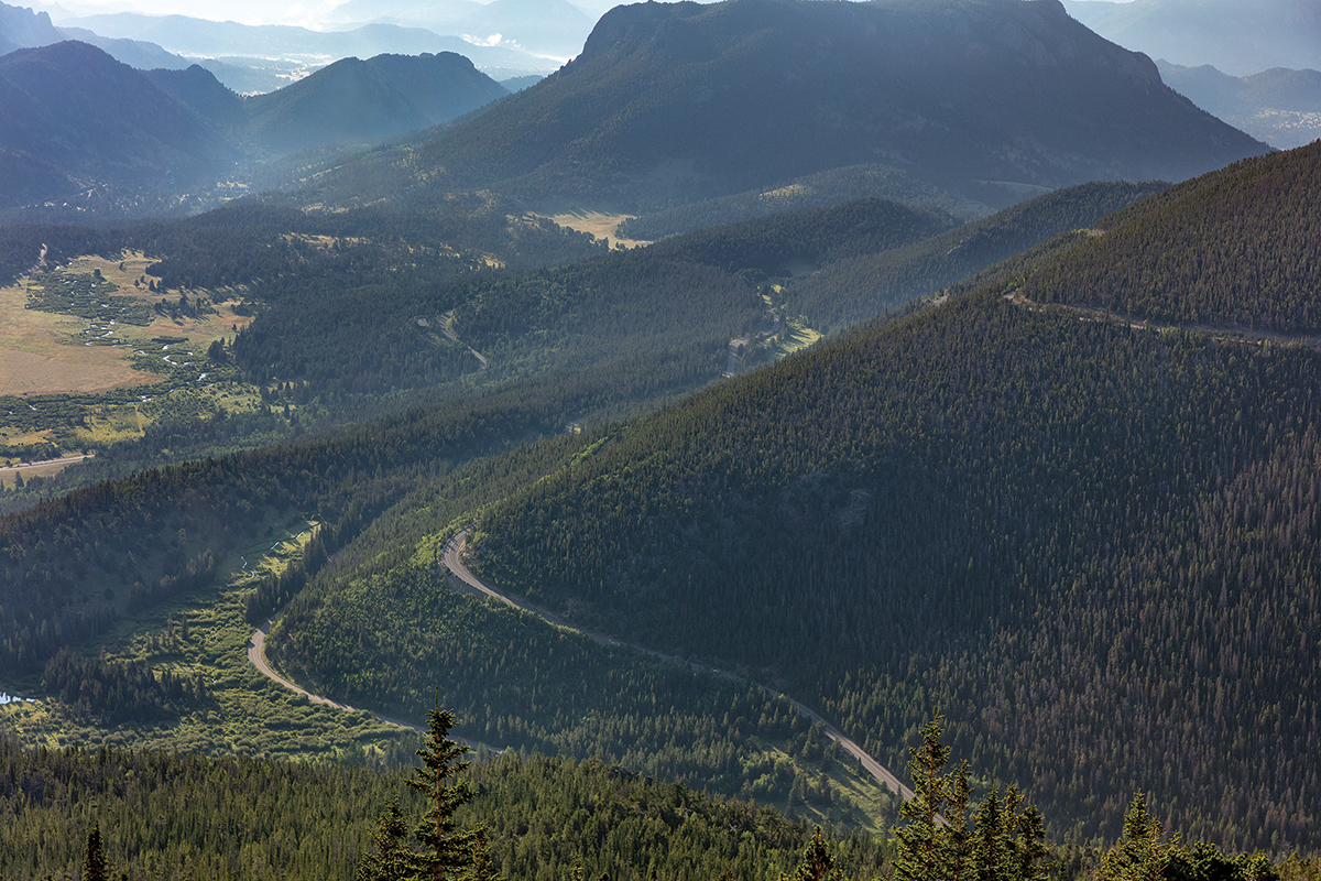
Trail Ridge Road, a.k.a. U.S. Highway 34, spans Rocky Mountain National Park and connects the town of Estes Park on the east side to Grand Lake on the western slope. It’s the highest continuous paved road in the U.S., reaching an elevation of 12,183 feet. It follows an historic path that the Ute and other Native American peoples used for thousands of years. The road is generally open from late May into October, weather dependent.
Here are a few fun facts to chew on before tackling the monster climb of Trail Ridge Road. The road between Estes Park and Grand Lake is 48 miles in length, 11 of which are above treeline. You ascend an average of 4–7 percent grade with a total of 4,170 feet of climbing required to reach the Continental Divide at an elevation of 12,183 feet at Fall River Pass. Such lofty elevation means it’s often windy with temperatures 20 to 30 degrees colder than on the valley floor. If you can brave the elements, the view on a clear day is astounding as you can see all the way to Wyoming and the Great Plains. As you climb, keep an eye out for alpine tundra residents like elk, pikas, marmots, and bighorn sheep.
You want to be prepared as Trail Ridge Road is an epic climb for any cyclist. If coming from lower elevation, get acclimated for several days ahead of the ride to avoid altitude sickness. The ride begins at 7,800 feet! Be highly visible (a flashing taillight really helps) and get a sunrise start before heavy automobile traffic picks up on the narrow road. During the summer months, watch out for daily afternoon thunderstorms. Bring an extra set of warm clothes and gloves along for the higher elevations and descents as the weather can turn ugly fast and even snow in summer.
This past July, I got an early start on my ride to avoid the throngs of gawking tourists in their automobiles. It was a crisp 46 degrees Fahrenheit, though I warmed up quickly with the uphill effort and abundant sunshine. Surging uphill at a steady cadence, I emerged above treeline to a tundra world of open terrain. The tarmac below my wheels was ultrasmooth, and I took in the spectacular landscape while watching for herds of elk and listening to the occasional chirps of pikas scurrying in rock piles adjacent to the road. It was a surreal ride, and I was surprised as there were even a couple of downhill breaks before I reached the highest park visitor center in the country. I must say that, in all of the researching and riding numerous outstanding national park roads, Trail Ridge Road was one of the most rewarding and satisfying rides.
Colorado is known for being a cycling destination, so there are plenty of other great riding options just outside of the national park. Try some of the great mountain bike trails near Estes Park. You can also pedal a mountain bike up the historic Fall River Road in the park, which supports one-way uphill traffic. It’s nine miles and 4,000 feet of elevation gain over the gravel road up to the visitor center along the park’s original road to the tundra area. You will have to descend back down the paved Trail Ridge Road.
The real secret to having a sublime ride in Rocky Mountain National Park is to be present when the roads are closed to automobiles but open to cyclists. This gift to cyclists occurs for several weeks in spring and then again in the fall. Contact the park to find when this golden opportunity is available.
Rocky Mountain National Park 970.586.1206
Recorded Trail Ridge Road conditions status report 970.586.1222
This story originally appeared in the May 2019 issue of Adventure Cyclist magazine.
