Heavy Metal Ghost Tour
This article first appeared in the July 2021 issue of Adventure Cyclist magazine.
“Is it going to be like this the whole way?” Courtney asked.
We’d gone 50 feet from the truck and already the road was unrideable. My partner Courtney and I were sleeping in the truck tonight and our bikes weren’t yet loaded, making this an inauspicious start to a four-day loop touring ghost towns and mining ruins in the heart of Colorado’s High Rockies.
The towering Sawatch Range — which includes the highest point in the Rocky Mountains, 14,433-foot Mount Elbert — while inhabited for eons, remained relatively untrammeled by European colonists until Ferdinand Hayden’s early 1870s geological surveys of the American West. It was the area’s extensive mineral deposits, starting with the discovery of a silver lode in Leadville a few years after Hayden, that sent the area’s population soaring. Mining camps emerged overnight and ballooned into boom towns, only to soon go bust and vanish due to misfortune, financial ruin, or, in the case of one ill-fated settlement, an avalanche that obliterated every building in town.
Reading about the region, I felt a strong sense of cognitive dissonance. Mining’s relics struck me as intriguing waypoints but also as potent symbols of unfettered resource extraction and its associated ills. That this land was stolen from the Ute, through treaties designed specifically to open new tracts to mining by forcing native people to relocate again and again, further stained the area’s legacy.
That dark history is inextricable with the history of the West. And as a recent transplant to Colorado, I was eager to not only see more of the state, but also to learn how it developed into what it is today, including its oft-whitewashed chapters. The trove of old rail beds and mining roads still lining the Sawatch, plus its modern network of high-alpine singletrack, offered endless opportunities to do both by bike.
That’s how Courtney and I found ourselves hiking our bikes up a scree-strewn road toward the Mary Murphy Mine. Notable for pioneering an aerial tramway to move ore down the mountain in suspended buckets, the Mary Murphy was the most prosperous gold mine in Chalk Creek. Though it ceased regular operation a century ago, many of the tramway’s towers still lined the hillside.
At a crest in the road, we came to a clearing where two buildings made of weathered wood and rusted metal sat askew. A stream trickled toward the road, staining the rocks the color of toothpaste. An advance call to the Forest Service had dissuaded us from bothering to bring a water filter — copious mining activity meant water sources were prone to high levels of heavy metals — and this affirmed our decision.
As darkness fell, we rode back to base camp to prepare our bikes and get some sleep. Sometime in the night, I crept from the truck to pee and stood awed by the immensity of the cosmos. Freed from light pollution, the Milky Way was a bright smudge across the sky. Starlight cast shadows along the canyon walls.
The next day’s riding assuaged our earlier concerns about the ratio of Type 2 fun that lay ahead, at least at first. It was all smooth dirt and small stones climbing a well-traveled, comfortable-grade forest road toward the site of Hancock (the town an avalanche destroyed) where we joined the Continental Divide Trail. Soon the trail grew steeper, the rocks bigger, and we were on foot switchbacking toward a ridge. Not what we’d hoped for, but not bad. We knew there’d be some hiking.
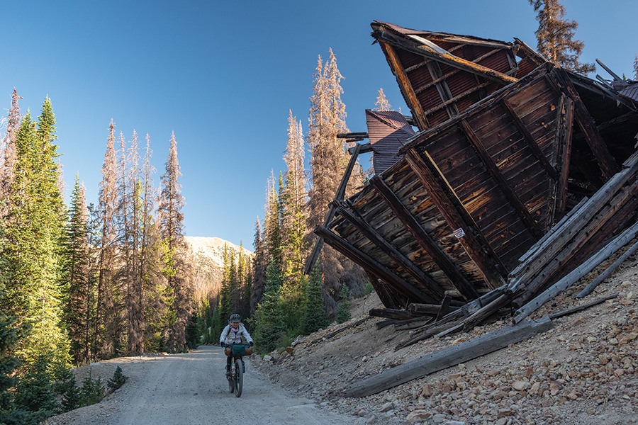
The descent brought us into a glacial amphitheater, abandoned train tracks running right down the middle and into the side of a mountain. At 11,500 feet above sea level, the 1,800-foot-long Alpine Tunnel was the world’s highest railway tunnel when completed in 1882. It was an engineering marvel and a dubious success. The Denver, South Park, and Pacific Railway began the tunnel in a race with its rival, the Rio Grande, to cross the Continental Divide and reach the Gunnison Valley. The Rio Grande won, and a cave-in closed the Alpine Tunnel for good in 1910.
From the tunnel’s sealed west portal, we paralleled train tracks toward the remnants of the station and surrounding town. Marmots lounged on the sunbaked bricks of collapsed buildings, seemingly the town’s only remaining inhabitants. Only one structure was intact, and to our surprise its door was not only unlocked, but a sign welcomed visitors inside. Old maps and photos lined the walls, including one of glum-looking men standing beside a monstrous bore as wide as a redwood. (Incidentally, engineers chose California redwoods for the tunnel’s support beams because of the trees’ natural flame retardance; more specifically, they used “butts” and “sinkers,” heartwood from the base of redwoods so dense it sinks in water.)
We ate lunch in the shadow of the sun-bleached building, grateful for shade above the tree line. As an inquisitive pika eyed us, nibbling its own snack, I thought about the perseverance it takes for small critters to survive in such an unforgiving environment. While we feasted on burritos, dried fruit, and candy, this creature the size of a Koosh ball was scavenging for morsels, in constant fear of predators, trying to fatten up ahead of a long, snowbound winter. The pika scurried off, and soon we were on our way as well.
Following the rail bed south, we came to another engineering feat: a narrow roadcut called the palisades hugging a sheer granite wall. With no other path, workers blasted a shelf into the mountainside and, because mortar was unavailable, cut and fitted the rubble into a 30-foot-high, 452-foot-long retaining wall. A sign proclaimed the palisades’ durability. No more than 100 yards away, an avalanche had blown a hole in the embankment as if to say, “Oh yeah?”
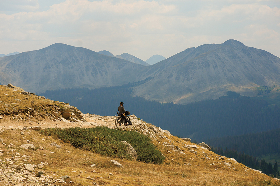
Granite cliffs encircled us as we rode into Quartz Creek Valley and the basin beneath 11,962-foot-tall Tomichi Pass. The road arced through alien terrain mottled with meager vegetation, its gentle contour a stark contrast to its rugged surface. The climb went easier than expected, though it required some hiking, and we came smiling down the other side. The giddiness was short lived.
Seeking grand views, we eschewed continuing our descent on the forest road in favor of first ascending an adjacent trail. The result was a demoralizing slog lugging our loaded bikes uphill into the midday sun. Somewhere in all the climbing, I lost a lens cap, a mishap we at first laughed off as mischievous spirits from a nearby ghost town playing a prank, but that felt more foreboding with each step.
When we reached the top, we were too exhausted to enjoy the view. Though we’d anticipated this first day being relatively easy — it had the shortest mileage and least climbing — we’d covered barely half the day’s distance by the time we wanted to be lounging in camp. As we caught our breath and discussed rationing candy, I worried about what I’d gotten us into. I’d hyped this trip for months, and now here we were, barely 10 miles in, shellshocked on a summit.
As difficult as our day had been, it paled in comparison to the hardships people had endured here before us. There’s a tendency to frame modern adventures as daring feats of discovery, but in reality, we were vacationers following long-established routes on portable computers equipped with GPS. Sure, there’s always risk when venturing into the outdoors. But rather than fearing death by starvation, our greatest fear was we’d run out of high-fructose corn syrup. A horror we wished not to ponder, but one we’d likely survive.
With that perspective reaffirmed, I took in our surroundings. Innumerable mountains stretched in all directions, their broad sides dappled in shadows from the racing clouds. A thin ribbon of singletrack ran through the tundra, following a few ridges before snaking down toward a creek, merciful shade, and camp. The smooth descent made for a sublime end to a long day, the only hiccup coming when Courtney’s handlebar bag flew off somewhere along the way. Fortunately, the bag wasn’t too far back up the trail, and this time we more easily laughed this off as the handiwork of impish spirits.
The morning came crisp and clear. The day’s riding would be one big loop, so we left camp intact and rolled out early, eager to ride some singletrack, unloaded, after the previous day’s travails.
Sows stared blankly as we pedaled past, their hides gleaming in the dawn. Sprawling pastureland gave way to groves of ghostly white aspens as we wound up a dirt road toward Old Monarch Pass, which would take us to (new) Monarch Pass and a rest stop on the paved highway. The passes are two of the innumerable notches along the Continental Divide, which separates the Atlantic and Pacific watersheds. To straddle these passes is, in effect, to put one foot on either side of the country.
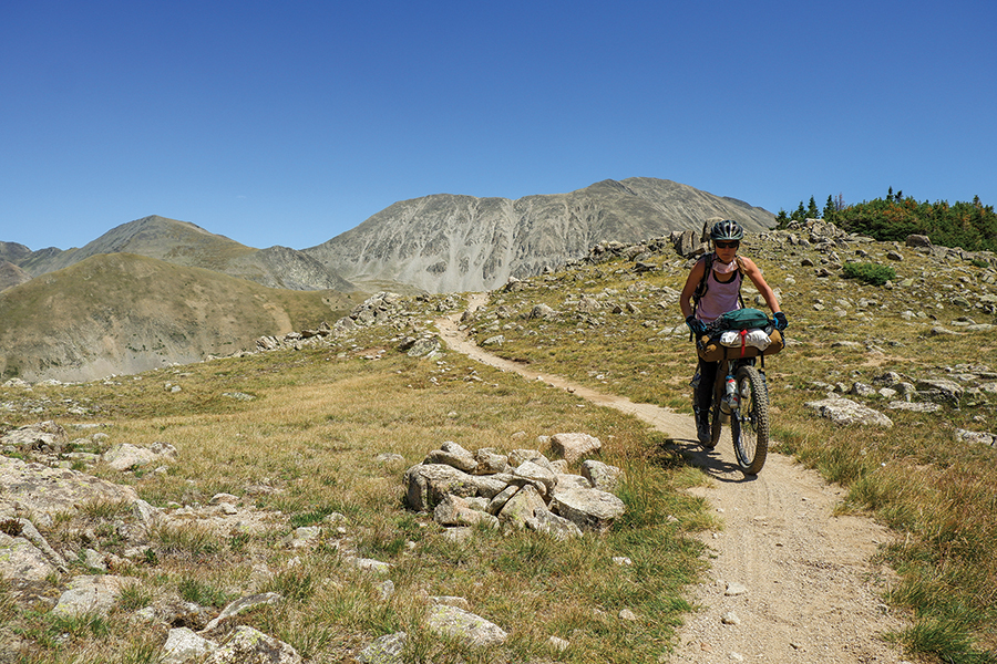
After topping off our water and powering up on junk food, we joined the Monarch Crest Trail, which departs from the rest stop. The renowned alpine singletrack lived up to its billing, swooping along a ridgeline with picturesque views at every turn. We would have ridden the trail’s length, but the way back to camp was down a different drainage.
We’d read that water crossings could be a nuisance, but the first few only splashed our shins. Farther along, we had to wade. With our legs already wet, we decided to sit for a while and soothe our swollen feet. The creek, made frigid from snowmelt, offered a much-needed respite from the August heat.
The trail dropped us back on the highway, and we raced downhill into the valley toward camp, relishing the rare feeling of a smooth surface beneath our wheels. There was just enough daylight left for a detour to an old graveyard outside Whitepine, a mining town where families still summer in well-preserved cabins. Plain white crosses marked most of the graves. A log near the wrought-iron gate named the known deceased, including a few pets.
Once again, the juxtaposition of mining’s hardscrabble, get-rich-or-die-trying lifestyle against the comparatively cushy nature of our trip struck me. Back at camp, we made fire from a can of compressed gas to rehydrate burritos (quinoa, beans, fresh salsa) and then slipped into sleeping bags (rated down to 15°F) in our ultralight tent. As with all nights in Colorado, we dozed without fear of grizzlies or wolves; humans extirpated both decades ago.
The third day of riding would take us deeper into the Gunnison National Forest and over three passes above 9,500 feet. Sage lined the dirt road as we pedaled west toward the first, Black Sage Pass. Even more sage greeted us on the other side in a sprawling, high-elevation pasture. A herd of cattle grazed aimlessly, ambling across our path if a random patch of greenery struck their fancy. We stopped far from the herd, giving them time to clear the road. A lone bull, dehorned but no less intimidating, turned our way. As if to warn the harem, he began bawling, a sound less like a moo than a tornado siren. Then he began trotting toward us.
We wheeled around as fast as we could. The bull trailed behind, but only for a short while before charging down into a ditch to rejoin some of the herd, who were now also running. They trailed away with a seesaw gait, their hooves lifting puffs of dust into the still morning air.
Our nemesis cowed, we continued on a gentle climb to Waunita Pass past dilapidated cabins reduced to piles of splintered lumber. Wary that the highest pass today would be our third and final, and having misjudged the difficulty of the previous two days, we minimized stops before reaching Pitkin for lunch. That way we could watch for signs of the afternoon storms that often sweep through the Rockies, unleashing a holy hell of hail and lightning and wind. After Pitkin, the route rose unendingly for 15 miles to Cumberland Pass. At an elevation of 12,000 feet, it was not where we wanted to find ourselves should the sky turn ornery.
In one sense, Pitkin is a quiet mountain town — dirt roads, modest homes, a population of a few dozen. However, with prime access to some of Colorado’s most popular 4×4 roads, there are few quiet moments during peak season. We found a snack shack adjacent to the town’s lone convenience store and seized the opportunity to order fresh food. As we sat in the sun enjoying veggie burgers and fries, the air hummed with the drone of ATVs, motorbikes, and trucks.
With no menacing clouds in sight, we headed north for Cumberland Pass. Making excellent time and spying a clearing that led to a creek alongside the road, we stopped to splash around and wash the dirt from our skin. Even with the unplanned stop, we reached the summit well before sunset. Smoke from wildfires in the western part of the state obscured even the closest peaks and cast the receding ridges in a hazy gray. We saw none of this smoke while climbing to Cumberland Pass; the high mountains had walled it all on the pass’s other side.
Finding a campsite close to the pass so we could ride back up for sunrise proved far harder than anticipated. In addition to the usual criteria — flat tent surface, privacy, shelter from wind — we had to consider private vs. public land. A frenzy of mining turned the mountain into a tangled mess of claims. (I’d later learn that at the boom’s outset, some three dozen mines operated in this gulch alone.) Though we were deep in a national forest, at times the only public land around was the road beneath our wheels.
Moving methodically in our search, I grumbled about this special place being divvied up and debased. All across the mountainsides, scars of sunken mines pockmarked the surface, mustard-yellow tailings spilling from their mouths.
Consulting maps and apps, we finally found a suitable spot that appeared to be in a cleft of public land between two claims. There were even good trees for our hammock. We curled up and swayed lazily as the sun set, the sky aflame as rays of light refracted through the smoky air.
In the cold predawn, we were back atop Cumberland Pass sharing a Thermos of coffee. The surrounding peaks gained definition in the dwindling darkness as color seeped in along the boundary between mountain and sky. Pastels bathed the rocks and clouds as we stood, alone together, greeting the day from atop the world.
With fingers of light still stretching across the hills, we rolled into Tin Cup, a town invariably described in history books as “rough.” Tin Cup’s first murder was over a horse trade gone sour. The killer, Frank Emerson, went on to become sheriff — only to be shot to death himself, one of three town marshals killed in Tin Cup’s first few years of existence.
One legend goes that the town got its name when a miner scooped gold from a stream in his tin camp cup. (A dubious claim, given the settlement’s original name was Virginia City; the change came decades later to allay confusion with the postal service about the many other western towns of the same name.) Today, Tin Cup remains sparsely inhabited. We paused just long enough to read a few signs. Only one climb remained, but we knew it would be no cakewalk. Famed for its ruggedness just like the town, Tin Cup Pass challenges even expert off-roaders.
ATVs buzzed past us on the rocky road to Mirror Lake, where a creek pools between two soaring escarpments. Even obscured by wildfire smoke, the view was breathtaking. We sat beneath trees on the far shore for lunch, where a clever bird sprinkled us with twigs. We took this as the equivalent of tapping someone on the shoulder and saying, “You gonna finish that?”
From there to the top, pedaling was futile. Ludicrous grades and boulders the size of beach balls forced some ATV drivers to turn back. We inched our way uphill, pausing often to catch our breath. Perhaps because we’d steeled ourselves for a long walk, or because we knew this was the last big hurdle, the trek seemed to pass quickly, and soon we were at the top. A family snapped selfies in front of their Jeep, one front wheel posed jauntily on a pile of rocks. Satisfied with the results, they piled back into the vehicle and rumbled out of sight.
The Sawatch Range spread out before us, pockets of snow still shining in the summer sun. Basking in the solitude, it dawned on us that the trip was almost done. It was, quite literally, all downhill from there. Despite the dire beginnings, we were going to complete the route. We even had candy to spare.
Smoother and less steep, this side of the pass was far more navigable by bike than the one we’d walked up. It helped that this time we were heading downhill. Whooping with glee, we tore down the mountain, occasionally launching off washed-out ruts across the road.
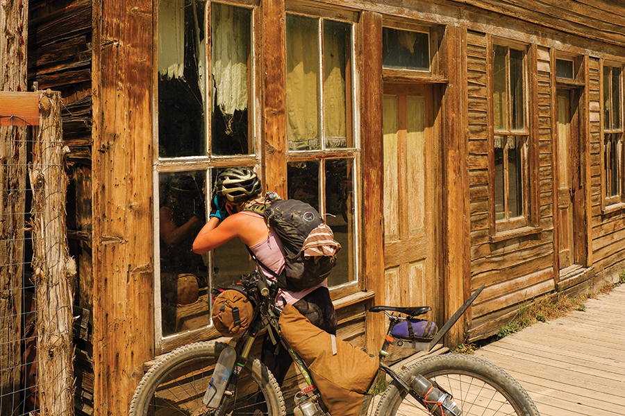
The jubilant descent brought us into St. Elmo, where a modern flurry of activity belied the place’s reputation as a ghost town. Cars crept in search of parking along a main street flanked by well-preserved buildings. A line for ice cream spilled into the road. Kids screamed, as kids do. With all its activity, St. Elmo felt more like the ghost of a ghost town.
Tempted by the prospect of beers and a nap, we began climbing the final few miles back to the truck. Signs declaring private property warned would-be trespassers against searching for scraps the mining conglomerates left behind. Though the principle of it offended us, we had no problem leaving the land as we found it. We’d gotten what we came for.
