Klamath Mountains Loop
- New Route
A remote loop through the Siskiyou, Trinity Alps, and Salmon subranges, tracing the newly free-flowing Klamath River.
- Distance
- 329 miles
- Surface
- 65% paved
- 1 week–3 weeks
- Route Type
- Loop
Ride the Klamath Mountains Loop
This loop starts and ends in Ashland, Oregon, and can be ridden in either direction, with a spur connecting to Medford for riders flying in.
What to Expect
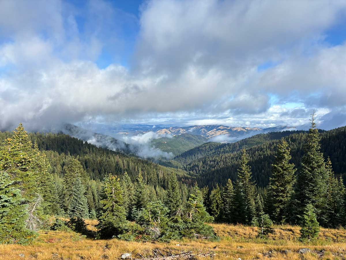
This loop leaves the comforts of Ashland behind almost immediately for remote highlands, old-growth forest, and the Klamath River, a Wild and Scenic waterway running free again after major dam removals. Three mountain crossings punctuate the route, each demanding in elevation gain and grade, with flatter, gentler river-canyon riding in between, where hot days give way to swimming holes and the smell of pine and river water. Solitude defines much of the ride: small towns and quirky local spots are the exception, not the rule.
Riders climb onto the Siskiyou Crest above 7,000 feet for sweeping views before descending to the Klamath River, flowing freely again after four dams were removed in 2024. The route also crosses the Trinity Alps and Salmon subranges through old-growth forest and climbs toward the historic Eddy Gulch Lookout. Small-town stops like the Seiad Valley Cafe, a favorite of Pacific Crest Trail hikers, offer a taste of local character between the big climbs.
The initial climb from Ashland to Mount Ashland gains nearly 4,700 feet in 15.6 miles, and the climb up Blue Ridge toward Eddy Gulch Lookout reaches grades of 21 percent. Carter Meadows Summit, at 6,207 feet, is the main route’s other big crossing, while the paved Etna Summit Alternate, at 5,987 feet, is steeper but shorter. Between climbs, the route follows gently graded river canyons lined with conifer forest and rocky bluffs. The full route includes detailed riding conditions and field notes for every climb and descent.
This is one of the more remote routes in the network, with long stretches between towns and limited services outside a handful of small communities. Bike shops are found only around Ashland and Medford, so carry the tools and spares to handle repairs yourself. Cell coverage is spotty to nonexistent in the mountains and canyons, so download your Ride with GPS route for offline use, and consider carrying a satellite communication device.
Ride this route from summer through early fall, since the high mountain crossings can hold snow into early summer. Expect hot days in the river canyons and cooler temperatures at elevation, with afternoon thunderstorms possible on exposed climbs. Fire season typically runs through late summer and early fall in southern Oregon and Northern California, and wildfire smoke can affect air quality even when the route is open.

Route Sections
Main Route, Ashland, OR to Ashland, OR, 329.3 miles
From Ashland, the route climbs to Mount Ashland and over the Siskiyou Crest, then descends to the Klamath River and follows it downstream past Seiad Valley. It then crosses the Salmon and Trinity Alps subranges, including the climb up Blue Ridge toward Eddy Gulch Lookout, before a final crossing of the Siskiyou Crest returns riders to Ashland. The full route includes turn-by-turn directions, service information, and field notes for the entire loop.
Alternates:
- South Fork Alternate. A fully paved option that bypasses the climbing near Forks of Salmon.
- Etna Summit Alternate. A fully paved crossing of Etna Summit, at 5,987 feet.
- Medford Spur. A fully paved connection to Medford and its airport.
Plan Your Ride
Three major climbs, few services, and a short snow-free window make careful planning the first step on this remote mountain loop.
Trip Planning & Logistics
Riders arriving by car can start in Ashland, and the Medford Spur connects the loop to Medford’s airport for those flying in. The route can be ridden in either direction, but check current conditions on all three summits for snow and washouts before choosing. Most riders plan four to seven days given the climbing involved. As a digital-only route, it’s available through Adventure Cycling’s shop as a Ride with GPS experience, which includes routing, detailed service information, riding conditions, and field notes for trip planning.
A gravel or touring bike with wider tires suits this route well, since the unpaved sections range from smooth gravel to steep, loose climbs. Low gearing is essential for grades that reach 21 percent. Pack a water filter, sun protection for exposed climbs, layers for the cooler mountain crossings, and bear spray.
Lodging is limited along much of this remote loop, so most riders camp several nights at Forest Service campgrounds or dispersed sites where permitted. A handful of small towns offer motels or cabins for an occasional indoor night, but reservations are worth making ahead, given how few options exist.
Resupply is limited to a handful of small towns along the route, so plan food carefully around the three major mountain crossings. The Klamath River and its tributaries offer regular surface water, but filter or treat it before drinking. Check your digital route in Ride with GPS for service phone numbers, and call ahead, since hours in small towns can be limited.
Wildfires are a real risk in late summer and early fall, so check current conditions before and during your trip, and head for lower ground if a thunderstorm builds on an exposed climb. Canyon roads can be narrow and winding with short sight lines, so wear bright clothing and watch for logging trucks. Black bears live throughout the region, so store food properly at camp, and watch for rattlesnakes and poison oak near trails and river access points.
Always check Adventure Cycling Route Updates and Corrections before you go.
Routes change. Bridges wash out, businesses close, and construction pops up overnight. We strive to keep routes updated as those things happen. When we learn about a change, we reroute around sections that have become dangerous or are temporarily closed for road work, bridge outages, or construction, and we update service information as businesses open, close, or move. Digital routes are updated as soon as we’ve reviewed a reported issue.
You’re often the first to spot these changes out on the road. Help us keep this route accurate for the next rider by reporting anything you notice with our Route Feedback Form.
This Route Is Part of Something Bigger
It’s one piece of the Adventure Cycling Route Network, began in 1976 and built on a simple mission: to empower people to travel by bike. Our team maps and maintains it; our members and donors make it possible.
-

Explore the Adventure Cycling Route Network
Our premium routes are well researched by our cartographers and well traveled by thousands of cyclists.
Adventure Cycling Route Network -
Support Route Development
Our members are the reason we can offer three route networks tailored for specific experiences and riders.
Become a Member -

Stay Connected
Find your stoke with our newsletter all about routes, gear, stories, and cycling news in your inbox twice a month.
Sign up for Bike Bits
Frequently Asked Questions
It’s our flagship, staff-built route network. The one that started it all 50 years ago with the TransAmerica Trail, the route that launched bicycle touring and bikepacking in America. Every route in it is designed and researched by our own team of cyclists and cartographers: months of research and on-the-ground testing go into each one, so what you get is more than a line on a map. Each Adventure Cycling route has detailed logistics, terrain and elevation info, points of interest, camping and lodging, safety alerts, and history, all in one place. It’s the most in-depth of our three networks, available as digital routes and most as paper maps too. It’s the route network we update most regularly as conditions change.
They’re related, but not the same thing. The Adventure Cycling Route Network is made up of routes we’ve researched, ridden, and mapped ourselves, chosen specifically for a great touring or bikepacking experience. The U.S. Bicycle Route System (USBRS) is a state-by-state national system that we serve as technical experts for, made official through each state’s department of transportation. The two overlap in a lot of places, but an ACRN route carries our own on-the-ground vetting; a USBRS route carries official state recognition.
It depends! If you want a route we’ve personally scouted end to end, with services, camping, and terrain notes built in, start with the Route Network. The ACA Route Network has routes of many different lengths and can be a much easier starting place for someone new to bicycle travel. If you’re an experienced cyclist piecing together an officially designated corridor, or riding somewhere the two systems converge, the interactive USBRS map is a good resource to use.
The Adventure Cycling Route Network is a premium network because of everything that goes into it. Unlike the U.S. Bicycle Route System (built by state DOTs) or Short Routes (submittedby cyclists in their own communities), every Adventure Cycling route is researched, ridden, and vetted end-to-end by our own team. Unlike other routes, Adventure Cycling routes come with extensive information on riding conditions, terrain notes, camping and lodging info, logistics, safety alerts, and points of interest. We also keep it current as roads and services change. The price supports that ongoing research and maintenance work, done by a nonprofit whose whole mission is making sure the route in your hands is one you can trust.
Turn-by-turn directions with a bike icon aren’t the same as a route built for specifically touring or bikepacking. Every mile in the Adventure Cycling Route Network has been researched and ridden by our staff and researchers, chosen to avoid dangerous traffic, and mapped with what a touring cyclist actually needs — food, water, camping, hotels, bike shops — spaced out along the way. The Adventure Cycling Route Network was built for cyclists by cyclists, is regularly updated, and comes with the resources and information needed to plan your ride.
No. The network includes routes for a wide range of experience and difficulty levels, from a first multi-day trip to a cross-country expedition. What every route has in common is that it was chosen with a touring cyclist’s needs in mind, whatever kind of trip you’re planning.
Not at all. Alongside iconic long-distance routes like the TransAmerica Trail, the network includes shorter regional routes, so it works for a weeklong vacation or a two-month journey.
For many years, we focused on paved routes, but today the network includes plenty of unpaved gravel riding for bikepacking. In fact, Adventure Cycling mapped the Great Divide Mountain Bike Route in 1998, arguably the most impactful bikepacking route in the world. The Adventure Cycling Route Network also includes the Golden Gravel Trail, Idaho Hot Springs Mountain Bike Route, Arkansas High Country Route, and more. Some routes are a 50/50 mix of pavement and gravel. Some routes follow paved and unpaved bike paths and rail trails. The Adventure Cycling Route Network has terrain for every cyclist.
We revisit our printed maps every three to five years, and push corrections to our digital route data as we learn about changes on the ground. If you have an Adventure Cycling Route in Ride with GPS that we’ve updated, you’ll get a notification when you open the route to update to the newest version of the route. Updating will ensure you have the latest data, information, and points of interest vital to being on route. For cyclists who have Adventure Cycling paper maps, we keep a list of route- and section-specific updates current on our Map Updates and Corrections page.
Change comes from two directions: our own staff research and reports from the cyclists actually out there riding them. If a bridge washes out, a shoulder disappears, a campground closes for repairs, or a town loses its only grocery store, that’s the kind of thing that triggers an update. You can help us keep our routes accurate; fill out our Route Feedback Form.
Most of our Adventure Cycling Routes come as waterproof print maps and digital Ride with GPS navigational data. Our print maps are the #1 longstanding popular resource for traveling cyclists. They are waterproof, highly detailed and always work. For long trips, many cyclists use a combination of print maps and digital routes.
If you’re already comfortable and familiar with a GPS navigational aid such as Ride with GPS or a Garmin, our digital data packages are an excellent choice. We do not recommend GPX data for beginners since there are a few extra steps to installing and troubleshooting.
Once you purchase a digital route, you’ll get an email with a link to unlock it in the free Ride with GPS app — no separate subscription required for basic navigation. From there you get turn-by-turn voice directions, curated points of interest like campgrounds and bike shops, and field notes on the history, geography, and climate along your route, all available 100% offline. If you’drather use a dedicated GPS device, you can export the route as a GPX file to load onto a Garmin, Wahoo, or similar device.
To export GPX files of your Adventure Cycling digital route, use your laptop or desktop to open the email you received after purchasing your digital route. Click on the link that allows you to access your Digital Route. Finally, click on EXPORT ALL at the bottom of the screen. This is the only way to export files that include the route line, points of interest, and services. Files will be exported as one ZIP file.
Adventure Cycling uses abbreviations across its paper and digital routes to indicate particular services, land or road types, route names, direction of travel, and route type. Please see our key to abbreviations.
If you have questions on how to purchase a digital route or about the route content, please contact Adventure Cycling: cartography@adventurecycling.org or 406-721-1776.
If you have questions on how to use your Digital Route in Ride with GPS, please check the Ride with GPS support page or email them at info@ridewithgps.com.
If you’re new to Ride with GPS, please check out the following resources:
Our print map panels aren’t always oriented northwards for space and layout reasons. Refer to the north arrows to help orient yourself if you’re not sure.
No. The Routes and Mapping Department does not do custom routes for individuals. Check out the routes we’ve already mapped, and use the interactive map to piece our route networks together, forming a route that gets you from a point A to point B of your choice.
It started with a single route. In 1976, we mapped the TransAmerica Trail, and more than 4,000 cyclists crossed the country together for Bikecentennial — the nation’s bicentennial cycling celebration our founders organized. That one route became the seed of a network we’ve spent the decades since expanding. Today it’s more than 58,000 miles of mapped routes across the U.S. and Canada, from classic epics like the TransAmerica Trail, Great Divide Mountain Bike Route, and Pacific Coast, to shorter regional routes.