Adirondack Park Loop
| Adirondack Park Loop | GPX Data | Overview | Buy | Mobile App |
|---|---|
| 1. Adirondack Park Loop Albany, NY to Albany, NY 1 Map Set | Detail |
Due to limited resources, the paper map versions of this route have been discontinued and will no longer be available once sold out. All sections of this route are still available digitally. More info here: Going Digital: App or GPX.
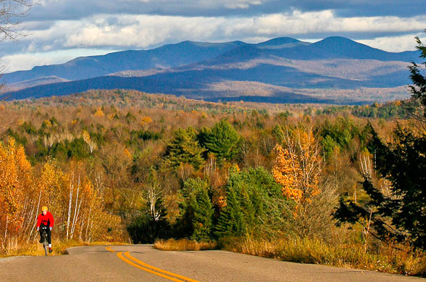
Explore Adirondack Park by bicycle.
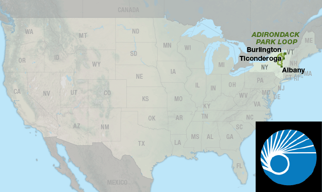
The Adirondack Park Loop is almost entirely within the boundaries of the Adirondack Park. Starting in Albany, New York, the route travels north through Saratoga Springs before crossing the “Blue Line,” the term that many locals and frequent visitors use for crossing the boundary into the park. Adirondack Park is the largest publicly protected area in the lower forty-eight states, greater in size than Yellowstone, Everglades, Glacier, and Grand Canyon national parks combined.
The loop gives an excellent representation of what northern New York has to offer. There is no shortage of beautiful scenery along the route as it travels mostly on roads with very little traffic. The route passes over rolling hills of rural farmland and historic battlefields, through quaint towns, and climbs to some of the highest elevation points in the state.
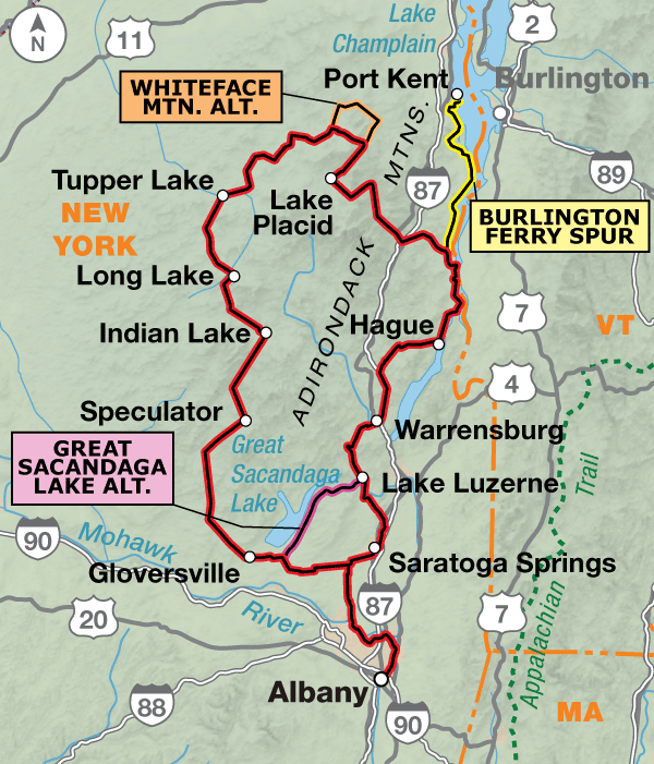
This loop begins and ends at Jennings Landing Amphitheatre in the capital city of Albany. You’ll follow the Mohawk-Hudson Bikeway along the Hudson and Mohawk rivers for some traffic-free riding to start the trip. After crossing the river and riding the first thirty-nine miles, you’ll need to decide to ride clockwise or counter-clockwise.
Heading counter-clockwise, cyclists will approach Saratoga Springs, famed for the Saratoga Race Course which is said to be the oldest continually operational sports venue of any kind in the country. Directly across the street from the race track is the National Museum of Racing and Hall of Fame, located at 191 Union Ave. There you can learn about stories like how the legendary Man O’ War lost the only race of his career to a horse named “Upset.”
Continuing north from Saratoga Springs, it’s a short 15 miles before entering the Adirondack Park. Half of the acreage of the park belongs to all of the people of New York State and is constitutionally protected to remain “forever wild.” The remaining half is private land that includes farms, businesses and homes.
Past Ticonderoga, the route starts to hug the shore of Lake Champlain. While there won’t be a notation along the actual roadway, you’ve also just joined up with Adventure Cycling’s Green Mountains Loop. Arriving in Port Henry, there is an optional spur route that continues north along Lake Champlain to Port Kent. Here you can take a ferry to Burlington, Vermont. The ferry, which runs eight times a day in the height of the summer and four times a day in the fall, takes an hour and ten minutes to cross Lake Champlain. It should be noted that the ferry only operates from mid-June until late September.
Staying on the main route, you will soon encounter Lake Placid. Most everyone associates Lake Placid with the Olympics, and for good reason, because the small town of 2,500 people has twice hosted the Winter Olympics. There is a host of activities to see and do around the town that are associated with the Olympics, from watching ski jumpers fly off of ramps into a pool of water, to seeing ice skaters practice pirouettes in the historic ice arenas. Combine all of this with the many hotels, restaurants and coffee shops, and Lake Placid is a great place to spend an extra day or two.
The route continues to travel through smaller towns. And while they might not have the notoriety of Lake Placid, they are quaint, scenic towns in their own right. Tupper Lake is home to The Wild Center, and Blue Mountain Lake is home to Adirondack Experience. Both places are a must see for park enthusiasts.
After leaving the park traffic increases so use caution. Twenty miles or so after Gloversville, you arrive back at the point where you had to choose your direction of travel.
The 32.7-mi. Great Sacandaga Lake Alternate connects Broadalbin and Hadley. This alternate stays within the park and skips Saratoga Springs.
Photo by Dennis Coello
The loop gives an excellent representation of what northern New York has to offer. There is no shortage of beautiful scenery along the route as it travels mostly on roads with very little traffic. The route passes over rolling hills of rural farmland and historic battlefields, through quaint towns, and climbs to some of the highest elevation points in the state.
| Adirondack Park Loop - Main Route | ||||
|---|---|---|---|---|
| Section | Distance | Elevation | Total Climb | Avg. Climb/mile |
| Total | 431.5 miles | Minimum: 0 ft.Maximum:2,380 ft. | 23,835 ft. counterclockwise23,890 ft. clockwise | 55 ft. per mi. counterclockwise55 ft. per mi. clockwise |
| Adirondack Park Loop Alternates | ||||
|---|---|---|---|---|
| Name | Section | Distance | Total Climb | Avg. Climb/mi |
| Whiteface Mountain Alternate | 1 | 23.0 miles | 1,860 ft. counterclockwise1,430 ft. clockwise | 81 ft. per mi. counterclockwise62 ft. per mi. clockwise |
| Burlington Ferry Spur | 1 | 43.4 miles | 3,400 ft. north bound3,485 ft. south bound | 78 ft. per mi. north bound80 ft. per mi. south bound |
| Great Sacandaga Lake | 1 | 32.7 miles | 1,425 ft. north bound1,650 ft. south bound | 44 ft. per mi. north bound50 ft. per mi. south bound |
This route can be ridden anytime between late spring to mid-fall (typically April to mid-September).
Even though the route travels through smaller towns in the park, there are a plethora of services that cater to tourists. Some cyclists may want to do this route during the colors of autumn. If you do, call ahead to verify campgrounds because many close after Labor Day. If staying indoors, or at campgrounds, advance reservations are recommended, especially on weekends.
Some campgrounds will charge a cyclist traveling alone less if they have hiker/biker sites, but often they will charge the price of a regular tent or RV site, and that can easily be $10-$30/night. If you’re friendly and ask around, you can often get yourself invited to camp in a yard. Our routes sometimes go through national forests (moreso in the west) and you are allowed to camp anywhere on national forest land as long as you “pack it in, pack it out.” Many city parks are free to camp in.
You may also wish to sign up with Warmshowers, a reciprocal hospitality site for bicycle travelers, for other overnight options.
Route Highlights
Adirondack Park Loop Highlights
- Adirondack Park
- Lake Placid
- John Brown State Historic Area
- High Falls Gorge
More Route Resources
- How to Travel with your Bike on Amtrak
- Bike the Bikeways
- Empire State Trail
- Mohawk Hudson Bikeway
- Bikeatoga (Saratoga Springs)
- Lake Champlain Ferries
- Fort Ticonderoga Ferry
- Lake Champlain Bikeways
- Bike Adirondacks
- Connect and share photos with other riders on Instagram: #acaAdironLoop
Updates to Recently Released Maps
If you are planning a bike tour, be sure to get the most recent map updates and corrections for your route by selecting the route, and the appropriate section(s), from the drop-down menu below.
Over time maps become less useful because things change. Every year Adventure Cycling’s Routes and Mapping Department create map updates and corrections for every map in the Adventure Cycling Route Network, which now totals 52,047 miles. With the help of touring cyclists like you, we receive updates on routing, services, camping, and contact information. Until we can reprint the map with the new information, we verify the suggested changes and publish corrections and updates here on our website.
PLEASE NOTE: Covid has been particularly hard on the small businesses along our routes. While we do our best to keep the maps and these online updates current, you may encounter more closed businesses and longer stretches with limited or no services.
Refer to these updates for the most current information we have and submit reports of changes to the Route Feedback Form for the cyclists coming after you.
NOTE: Map updates and corrections only pertain to long term changes and updates. For short term road closures, please see the Adventure Cycling’s Routes Temporary Road Closures discussion in our Forums.